It looks like you're using an Ad Blocker.
Please white-list or disable AboveTopSecret.com in your ad-blocking tool.
Thank you.
Some features of ATS will be disabled while you continue to use an ad-blocker.

Strange-I Suppose there is an Explination...When do Normal Flights Operate Like this? Y in the Sky?
page: 13
share:
Pics I took when I looked up driving out of my mother's neighborhood awhile back I hope you can see it, but two "planes" came from one "contrail" to
form a perfect "Y". I find this highly odd. Thoughts?


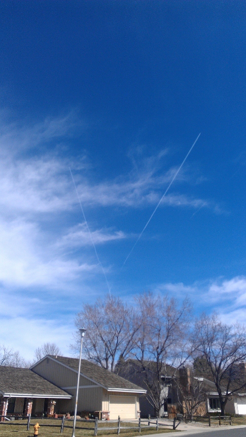
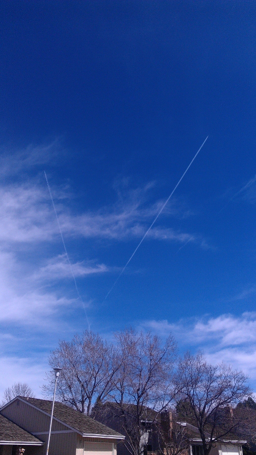
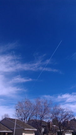
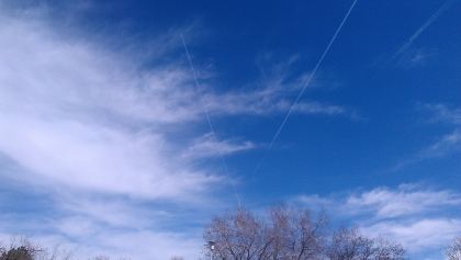
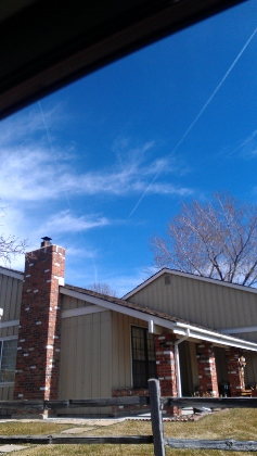

If you really look you can see where they started out "together"...no question about it.
ColoradoJens
If you really look you can see where they started out "together"...no question about it.
ColoradoJens
edit on 27-4-2012 by ColoradoJens because: (no reason given)
edit on 27-4-2012 by ColoradoJens because: (no reason
given)
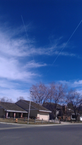
To me the one on the left looks pretty straight. Hold a ruler up to it.
Probably two flights taking off from the same runway minuets apart. Have to get to a certain altitude/bearing before changing flight paths is my guess.
Probably two flights taking off from the same runway minuets apart. Have to get to a certain altitude/bearing before changing flight paths is my guess.
reply to post by Vardoger
I agree and thought of that...however when they first started "parting" ways they seemed awfully close; from my perspective they were on top of each other. It took me maybe 30 seconds to pull over and take the pics...not my norm but something compelled me...they seperated rather quickly - should they be this close even if the path was to be used by both?
CJ
Thats a pretty cool coincidence of perspective and altitude for the Contrails. I'd offer this as to why it isn't too shocking though (Excuse the
size....shrinking would have made a cluttered mess all the tougher to see)
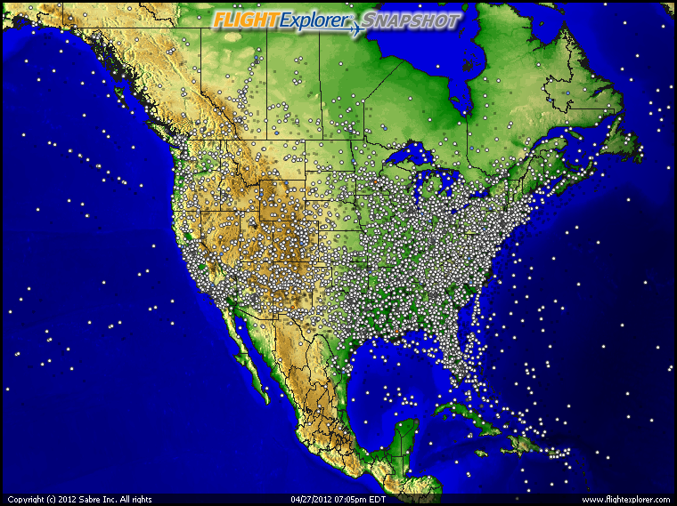
That is by no means all the aircraft currently over the United States. I'm guessing that isn't even all of the Commercial aircraft squawking to Control towers. It's enough to get the image of how covered we are at any given moment by aircraft overhead...going wherever each one is going. They're bound to form patterns occasionally by sheer odds and coincidence?
That is by no means all the aircraft currently over the United States. I'm guessing that isn't even all of the Commercial aircraft squawking to Control towers. It's enough to get the image of how covered we are at any given moment by aircraft overhead...going wherever each one is going. They're bound to form patterns occasionally by sheer odds and coincidence?
reply to post by Wrabbit2000
Most certainly so. I rule out nothing. I just have never seen this before. Thanks for the pic!
CJ
Most certainly so. I rule out nothing. I just have never seen this before. Thanks for the pic!
CJ
reply to post by ColoradoJens
I thought they were interesting pictures. I guess this is more common place than I thought?
CJ
I thought they were interesting pictures. I guess this is more common place than I thought?
CJ
Aircraft fly on airways and/or jetroutes, which are highways in the sky. They are made up of two coincidental radials off of two seperate NAVAIDS.
Simply put, point to point navigation through the use of courses produced by ground based stations. Where two airways/jetroutes intersect over a
NAVAID could cause this pattern in your picture.
As far as how close they are, trust me they are not close at all. Your perspective on the ground is very skewed and just because you see flightpaths cross, does not mean that the aircraft are co-altitude. The minimum separation at the altitude those aircraft were operating at would be 5 miles laterally.
Dont worry about how close they looked. Trust me, they were obviously in what ATC world calls the enroute phase of flight, and when in Class A airspace, there is little fear of a mid-air collision or possibility. The equipment capability of air traffic control centers, coupled with the pre-separation built in my flow control, makes the chances of two planes hitting while at cruise alititude very unlikely.
Air Traffic Controller here with 15 years experience.
Nice pics!
reply to post by AtcGod
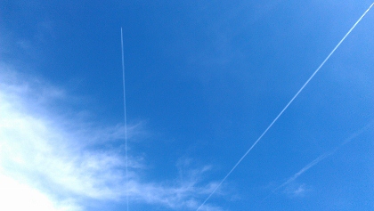
Thanks for that explination. It makes sense. I should state that I watched both planes "appear" from the first contrail (hard to see but it makes up the "I" part of the "Y") and they were literally side by side. I took the pics after they seperated and by that time, yes, they were some distance apart. How far apart do they typically let flanes use the same "sky runway"? It seemed (and yes, by no means am I aviation expert) that they had to have taken off and gotten to their angling' point almost simultaneously. Pretty cool looking nonetheless.
CJ
reply to post by ColoradoJens
Just because you saw them near the same point in space at the same time does not mean they took off at the same time, or even from the same airport. These aircraft are enroute, and by there diverging courses, they obviously are comming from two seperate directions.
Think of it like this, one aircraft could have taken off from Denver heading to Miami 2 hours before, and another could have just taken off from say an airport 50 or 60 miles from you headed to Dallas. They are both on these airways/jetroutes that cross over the same groundbased NAVAID that is sending out radio signals in the form of 360 courses in which the different aircraft can dial into thier instruments and follow.
I understand that It may have looked like they were one plane that split into two, but they probably were just crossing flight paths.
reply to post by ColoradoJens
Also to answer your question, 4 miles either side of the course is considered protected airspace on the airway. The standard seperation for aircraft laterally is either 3 or 5 miles depending on how far they are away from the Radar or how many feeds you have coming into the ATC facility and if you are using more than a single sensor mode such as Mosaic Mode.
Also to answer your question, 4 miles either side of the course is considered protected airspace on the airway. The standard seperation for aircraft laterally is either 3 or 5 miles depending on how far they are away from the Radar or how many feeds you have coming into the ATC facility and if you are using more than a single sensor mode such as Mosaic Mode.
reply to post by ColoradoJens
Hello, "Jen"...."member atcgod" did part of it....here is more, for you to explore....for those of us lucky enough to be in the USA....this ONLINE service uploads actual, and current, Aviation Charts to this site:
skyvector.com...
NOW....next step, for you (and, please feel free to send me U2U, I will walk you though it!).....if you have ANY questions!! (Free of charge!!).....
....go to "skyvector" and input the location.....I'm guessing you're in n'Colorado'?? (Not hard to figure out)....
So, here:
TAKE a look at this link:
Enroute H-5
THAT ( ^ ^ ^ ) is the "high" page......look for more, as explained below.
Denver-area WAC
See anything familiar??
If NOT....then, feel free to send me a U2U....I will happily teach you....for FREE!!!!
(edit)...please review the links, and know that at the ENDS of the charts are panels that provide a LOT of info, to explain symbols, and such......you can learn a LOT by just scrolling around....but again, ANY questions, I can answer...just have to ask!!!
Best, to all...TJ!
edit on Sat 28 April 2012 by ProudBird because: (no reason given)
reply to post by ColoradoJens
Under the chart link to the site the previous poster provided, the Low Enroute Charts will depict airways (Below FL 180) and the High Enroute Charts will depict the Jetroutes (Above FL 180).
Good luck!
Under the chart link to the site the previous poster provided, the Low Enroute Charts will depict airways (Below FL 180) and the High Enroute Charts will depict the Jetroutes (Above FL 180).
Good luck!
reply to post by AtcGod
Yup!!! What he/she said!!
AND again......I am ALWAYS available by U2U....and I think, though cannot speak for them....member "AtcGod" knows a lot, too......!!!!
Yup!!! What he/she said!!
Under the chart link to the site the previous poster provided, the Low Enroute Charts will depict airways (Below FL 180) and the High Enroute Charts will depict the Jetroutes (Above FL 180).
Good luck!
AND again......I am ALWAYS available by U2U....and I think, though cannot speak for them....member "AtcGod" knows a lot, too......!!!!
new topics
-
HORRIBLE !! Russian Soldier Drinking Own Urine To Survive In Battle
World War Three: 5 minutes ago -
Bobiverse
Fantasy & Science Fiction: 2 hours ago -
Florida man's trip overseas ends in shock over $143,000 T-Mobile phone bill
Social Issues and Civil Unrest: 3 hours ago -
Former Labour minister Frank Field dies aged 81
People: 5 hours ago -
SETI chief says US has no evidence for alien technology. 'And we never have'
Aliens and UFOs: 6 hours ago -
This is our Story
General Entertainment: 9 hours ago -
President BIDEN Vows to Make Americans Pay More Federal Taxes in 2025 - Political Suicide.
2024 Elections: 11 hours ago
top topics
-
President BIDEN Vows to Make Americans Pay More Federal Taxes in 2025 - Political Suicide.
2024 Elections: 11 hours ago, 14 flags -
Should Biden Replace Harris With AOC On the 2024 Democrat Ticket?
2024 Elections: 17 hours ago, 6 flags -
One Flame Throwing Robot Dog for Christmas Please!
Weaponry: 16 hours ago, 6 flags -
SETI chief says US has no evidence for alien technology. 'And we never have'
Aliens and UFOs: 6 hours ago, 5 flags -
Florida man's trip overseas ends in shock over $143,000 T-Mobile phone bill
Social Issues and Civil Unrest: 3 hours ago, 5 flags -
Former Labour minister Frank Field dies aged 81
People: 5 hours ago, 4 flags -
Don't take advantage of people just because it seems easy it will backfire
Rant: 16 hours ago, 4 flags -
Ditching physical money
History: 16 hours ago, 4 flags -
This is our Story
General Entertainment: 9 hours ago, 3 flags -
Ode to Artemis
General Chit Chat: 12 hours ago, 3 flags
active topics
-
SETI chief says US has no evidence for alien technology. 'And we never have'
Aliens and UFOs • 27 • : Degradation33 -
President BIDEN Vows to Make Americans Pay More Federal Taxes in 2025 - Political Suicide.
2024 Elections • 61 • : CriticalStinker -
University student disciplined after saying veganism is wrong and gender fluidity is stupid
Education and Media • 46 • : YourFaceAgain -
HORRIBLE !! Russian Soldier Drinking Own Urine To Survive In Battle
World War Three • 0 • : DISBOLD -
Ditching physical money
History • 17 • : SprocketUK -
The Reality of the Laser
Military Projects • 39 • : Scratchpost -
-@TH3WH17ERABB17- -Q- ---TIME TO SHOW THE WORLD--- -Part- --44--
Dissecting Disinformation • 640 • : Thoughtful3 -
Who are the Russians?
New World Order • 201 • : DISBOLD -
Geddy Lee in Conversation with Alex Lifeson - My Effin’ Life
People • 5 • : underpass61 -
Europe declares war on Russia?
World War Three • 68 • : DISBOLD
3