It looks like you're using an Ad Blocker.
Please white-list or disable AboveTopSecret.com in your ad-blocking tool.
Thank you.
Some features of ATS will be disabled while you continue to use an ad-blocker.

What does a catastrophic earthquake in the US look like?
page: 16
share:
Well, there is little need to wonder what a mega-quake in the U.S. would look like. A recent thread inspired putting this together but isn't intended
to discuss that. It did occurr to me though that few people have probably dug into Government sites deeply enough to realize Uncle Sam has asked this
question. Repeatedly. Uncle Sam has put his best minds on it and they've not only come up with an answer of what this will look like some day, but
specifically, what it will likely feel like in different areas based on geology.
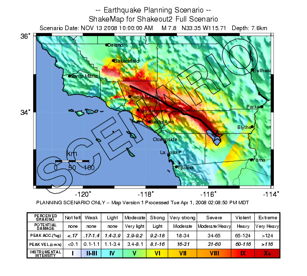
Here is the Los Angeles area after a 7.8 quake is projected and run as a scenario by the U.S.G.S.:
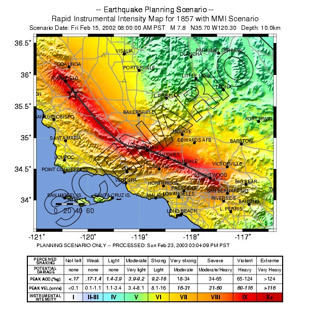
...and here is a historical 7.8 quake in the same region but from a slightly different fault line for geography and geology.
Source
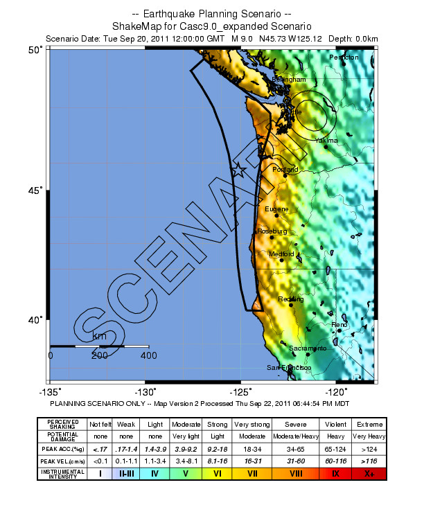
The difference in effect is striking. However, it's amazing to see just how critical those factors are for making calamity vs. a very bad day. Here is a staggering 9.0 off the Pacific Northwest.
and finally, I am sure everyone would feel a little jipped if I didn't include this one for context and pure doom porn fascination. Be honest now... Here is New Madrid, Missouri. It's not quite the same level of the last triple set of quakes, but close enough for context.

Source
Now these scenario maps show a scale a little different than most people are used to seeing on the MSM reports. Everyone is familiar with the numbered scale showing strength. The Roman Numerals at the bottom of these scales are something different though and it isn't simply a variation to display the same number. It's called the Mercalli Scale and I believe it's actually more relevent to the actual impact of a quake.
As the 9.0 shows, an ENORMOUS quake isn't necessarily a calamity for the land nearby. Likewise, the 7.8 in the L.A. Basin is deep red across a sickening area I personally know as very dense population that just runs as solid city across that whole area of the map.
The Mercalli Scale for Earthquake Intensity and Damage
Anyway, I thought everyone might find this interesting for context and some mental perspective for what quakes of this size are projected to look like in a real and literal way. Uncle Sam really has taken the time to know.
Here is the Los Angeles area after a 7.8 quake is projected and run as a scenario by the U.S.G.S.:
...and here is a historical 7.8 quake in the same region but from a slightly different fault line for geography and geology.
Source
The difference in effect is striking. However, it's amazing to see just how critical those factors are for making calamity vs. a very bad day. Here is a staggering 9.0 off the Pacific Northwest.
and finally, I am sure everyone would feel a little jipped if I didn't include this one for context and pure doom porn fascination. Be honest now... Here is New Madrid, Missouri. It's not quite the same level of the last triple set of quakes, but close enough for context.
Source
Now these scenario maps show a scale a little different than most people are used to seeing on the MSM reports. Everyone is familiar with the numbered scale showing strength. The Roman Numerals at the bottom of these scales are something different though and it isn't simply a variation to display the same number. It's called the Mercalli Scale and I believe it's actually more relevent to the actual impact of a quake.
As the 9.0 shows, an ENORMOUS quake isn't necessarily a calamity for the land nearby. Likewise, the 7.8 in the L.A. Basin is deep red across a sickening area I personally know as very dense population that just runs as solid city across that whole area of the map.
The Mercalli Scale for Earthquake Intensity and Damage
Anyway, I thought everyone might find this interesting for context and some mental perspective for what quakes of this size are projected to look like in a real and literal way. Uncle Sam really has taken the time to know.
edit on 24-4-2012 by Wrabbit2000 because: (no reason given)
reply to post by Wrabbit2000
A sensible part of your post is that each of those earthquakes has a decent chance of happening in a few hundred years. One can construct horrific scenarios across the Midwest, through Seattle, or around New England, but the chances of those are more remote.
These $100B+ quakes are sobering.
A sensible part of your post is that each of those earthquakes has a decent chance of happening in a few hundred years. One can construct horrific scenarios across the Midwest, through Seattle, or around New England, but the chances of those are more remote.
These $100B+ quakes are sobering.
Originally posted by JohnVidale
reply to post by Wrabbit2000
A sensible part of your post is that each of those earthquakes has a decent chance of happening in a few hundred years. One can construct horrific scenarios across the Midwest, through Seattle, or around New England, but the chances of those are more remote.
These $100B+ quakes are sobering.
These are 100% scenarios, of course. It's all a part of what the U.S.G.S. creates and makes public on it's site. In terms of actual likelihoods go, the USGS also covers that, actually.
Various probability maps of the lower 48 states and other areas
The odds that any one of these quakes actually happen in the near future are remote to the extreme and even out to 50 years on the USGS national projection the link above shows, it's not likely. So..Odds are, none of us see a super-quake like this in the U.S. in our lifetimes. At least, we all hope to be so lucky.
When one eventually does happen again, that's what it'll probably look like though. If we run a timeline out far enough, the odds are probably 100% on each or real close to it. It's a loooong timeline though.
reply to post by Wrabbit2000
My impression is that the ShakeOut2 scenario is about a one in 500 to 1000 years recurrence - it packs more wallop than the standard 200-300 year event on that section of fault.
The event in New Madrid is also about once in 500 years, based on 3 recurrences in the last 2000 years.
Cascadia is fairly accurately known to be a 1 in 300 chance per year.
The Carrizo to the Salton Sea might be more unlikely, I think the standard event with the Carrizo plain, like the one in 1857, breaks a shorter stretch of fault.
So overall that's maybe a 50% chance in 50 years of one of those events happening?
The thought of a quake on the New Madrid terrifies me. Not for myself or wife and kids necessarily, for my mom.
I live in Central IL now and she is still in Ky, 3 1/2 hrs away. Between us, there are who knows how many small bridges and 1 major.bridge. If the Shawneetown Bridge were out, [joins IL and KY in Shawneetown IL] which is almost certain to be impassable, then I would have to try to re route to one near Carmi, IL between Illinois and Evansville, Indiana. Both would likely be down and no other way to get to her. Along with that, cell towers are likely to be down, so no means of communication for an untold length of time.
I live in Central IL now and she is still in Ky, 3 1/2 hrs away. Between us, there are who knows how many small bridges and 1 major.bridge. If the Shawneetown Bridge were out, [joins IL and KY in Shawneetown IL] which is almost certain to be impassable, then I would have to try to re route to one near Carmi, IL between Illinois and Evansville, Indiana. Both would likely be down and no other way to get to her. Along with that, cell towers are likely to be down, so no means of communication for an untold length of time.
reply to post by DAVID64
I'm up in the Springfield area myself and on the outer edge of the major damage area. As I've read the maps, we'll feel it to be sure, but it's all wood frame housing for the most part and we wouldn't get hurt too bad up here. That probably makes this one of the major staging areas for aid and assistance into the area further east.
I'd thought about the rivers but we have a likely solution for that fairly quick here..at least I hope. The Army Corps of Engineers has equipment all over the Mid-West and temporary bridge spans must be part of it. One of their Headquarter centers in there in Oklahoma and only about 9 hours in a good drive. I'd hope the road traffic wouldn't be cut off for too long. If this all happens in my lifetime, it's Memphis I worry about the most. Virtually everything down there is un-reinforced brick facade and similar construction. Great for storms, horrible for Earthquakes.
reply to post by Wrabbit2000
Hopefully traffic in to the area wouldn't be restricted for too long. I know they keep out the sightseers in disaster areas, but if I can convince them I have a relative I Need to get to, maybe they'll let me in.
Hopefully traffic in to the area wouldn't be restricted for too long. I know they keep out the sightseers in disaster areas, but if I can convince them I have a relative I Need to get to, maybe they'll let me in.
I live in map number 3.
it says mag 9.0, depth 0.0km, wouldn't that be impossible? a subduction zone surface quake? lol
i'm not worried about the 'megaquake' which will be mainly offshore, as much as i'm concerned about a 7.0 - 8.0 quake closer to the cities or under them. the last quake we had that I felt personally was in 2001, that was a 6.8.
it rolled my pencil off my desk, nothing spectacular.
but the next one, could happen any time now and could be closer/stronger.
I'm right in that red zone in Southern California... yay!
Man I need to get out of here.
Man I need to get out of here.
reply to post by yourmaker
The plate boundary across the entire area outlined in black would slip, averaging 10-20m of motion (on the fault). The depth would only be zero right at the trench, where the fault surfaces offshore, under kms of water.
The plate boundary across the entire area outlined in black would slip, averaging 10-20m of motion (on the fault). The depth would only be zero right at the trench, where the fault surfaces offshore, under kms of water.
new topics
-
God's Righteousness is Greater than Our Wrath
Religion, Faith, And Theology: 3 hours ago -
Electrical tricks for saving money
Education and Media: 6 hours ago -
VP's Secret Service agent brawls with other agents at Andrews
Mainstream News: 8 hours ago -
Sunak spinning the sickness figures
Other Current Events: 8 hours ago -
Nearly 70% Of Americans Want Talks To End War In Ukraine
Political Issues: 9 hours ago -
Late Night with the Devil - a really good unusual modern horror film.
Movies: 10 hours ago
top topics
-
VP's Secret Service agent brawls with other agents at Andrews
Mainstream News: 8 hours ago, 9 flags -
Cats Used as Live Bait to Train Ferocious Pitbulls in Illegal NYC Dogfighting
Social Issues and Civil Unrest: 12 hours ago, 8 flags -
Electrical tricks for saving money
Education and Media: 6 hours ago, 4 flags -
HORRIBLE !! Russian Soldier Drinking Own Urine To Survive In Battle
World War Three: 16 hours ago, 3 flags -
Nearly 70% Of Americans Want Talks To End War In Ukraine
Political Issues: 9 hours ago, 3 flags -
Sunak spinning the sickness figures
Other Current Events: 8 hours ago, 3 flags -
Late Night with the Devil - a really good unusual modern horror film.
Movies: 10 hours ago, 2 flags -
The Good News According to Jesus - Episode 1
Religion, Faith, And Theology: 14 hours ago, 1 flags -
God's Righteousness is Greater than Our Wrath
Religion, Faith, And Theology: 3 hours ago, 0 flags
active topics
-
How ageing is" immune deficiency"
Medical Issues & Conspiracies • 34 • : angelchemuel -
Nearly 70% Of Americans Want Talks To End War In Ukraine
Political Issues • 13 • : Freeborn -
Mood Music Part VI
Music • 3101 • : ThatSmellsStrange -
VP's Secret Service agent brawls with other agents at Andrews
Mainstream News • 41 • : ThatSmellsStrange -
HORRIBLE !! Russian Soldier Drinking Own Urine To Survive In Battle
World War Three • 32 • : DaRAGE -
New whistleblower Jason Sands speaks on Twitter Spaces last night.
Aliens and UFOs • 55 • : baablacksheep1 -
Cats Used as Live Bait to Train Ferocious Pitbulls in Illegal NYC Dogfighting
Social Issues and Civil Unrest • 20 • : Asher47 -
Electrical tricks for saving money
Education and Media • 4 • : Lumenari -
DONALD J. TRUMP - 2024 Candidate for President - His Communications to Americans and the World.
2024 Elections • 514 • : WeMustCare -
The Acronym Game .. Pt.3
General Chit Chat • 7744 • : bally001
6