It looks like you're using an Ad Blocker.
Please white-list or disable AboveTopSecret.com in your ad-blocking tool.
Thank you.
Some features of ATS will be disabled while you continue to use an ad-blocker.

The weather (an observation)
page: 1share:
I wanted to say a little something about the weather today. I live in Lincoln Nebraksa. I have lived in Nebraska a long time, seen a lot of things
happen in the sky out here. I've witnessed more than my fair share of tornadoes, hail, flooding, and skies of every color.
But today were having an out break of tornadoes and heavy rains that seems strange. The temperatures just don't seem to be high enough to produce tornadoes from the experiences I have had in the past. This morning there was a heavy fog (1/4 mile visibility to an 1/8th mile or less at times and it seems to be raining way to much now for it to produce any type of tornado. Also me plus a few people at work say their ears are ringing.
just an observation...
People with better meteorological background then me can feel free to dispute this if its wrong, but my understanding is that tornado’s spawn from
storm fronts (the leading edge). They are the normally horizontal leading edge, that gets pushed down. The rain is in the center of the storm, after
the front, and the whole thing resides in a low pressure system, making it colder. So the cold indicates a pressure system moved in, then you get the
tornado's in the leading edge of the storm front, followed by the rain after the front passed.
I think the same thing. I believe this is weather manipulation at it finest. Since when are they able to predict "an outbreak of tornadoes" a few
days in advance? And be right on the money on where! CNN had a huge thing on the "storms" and said there could be hundreds of tornadoes Sat. I heard
this yesterday.
reply to post by AllUrChips
They have always been able to predict in advance when conditions were favorable enough to produce tornado's. Heck I remember the alerts on TV when I was a kid. I think that they have just gotten better at it, and more interconnected between news and weather stations between states. The Doppler radars they have now will let them see where a tornado is about to form, and actually see it when its on the ground. I believe that they got good at spotting that when they started storm chasing with mobile Doppler radar systems.
They have always been able to predict in advance when conditions were favorable enough to produce tornado's. Heck I remember the alerts on TV when I was a kid. I think that they have just gotten better at it, and more interconnected between news and weather stations between states. The Doppler radars they have now will let them see where a tornado is about to form, and actually see it when its on the ground. I believe that they got good at spotting that when they started storm chasing with mobile Doppler radar systems.
reply to post by defcon5
Yeah I remember alerts as well, maybe a few hours in advance. I GUARANTEE you have never seen alerts TWO DAYS in advance of "hundreds" of tornadoes to hit and provide a path for them. I believe the tornadoes last year in Joplin were part of these manipulations as well.
Yeah I remember alerts as well, maybe a few hours in advance. I GUARANTEE you have never seen alerts TWO DAYS in advance of "hundreds" of tornadoes to hit and provide a path for them. I believe the tornadoes last year in Joplin were part of these manipulations as well.
It just seems like the wrong kind of weather to even be producing storms. Then again, three weeks ago its was over 90 degrees in Nebraska. The ups and
downs don't make any sense at all.
All my life living in Nebraska tornadoes only really popped up when the temps got in the 90s, maybe 87 - 88 degrees at the lowest.
It was 64 at the highest today in Lincoln, some parts of Nebraska may have seen the 70's, but still that's not typical tornado weather at all. also one storm cell is the size of Iowa at the moment. Not unheard of, but suspiciously concentrated.
reply to post by SecretNebraska
the ears ringing part is very interasting, that sucks though that you guys are experiancing such bad weather, hope it gets better
the ears ringing part is very interasting, that sucks though that you guys are experiancing such bad weather, hope it gets better
www.youtube.com...#!
Look up the conditions for North Platte Ne. That video happened there today. For these weather conditions it is super rare occurrence of tornadoes.
Look up the conditions for North Platte Ne. That video happened there today. For these weather conditions it is super rare occurrence of tornadoes.
reply to post by AllUrChips
Yeah, but you have to understand back then we didn't have as many radars, and they weren't interconnected like they are today. It used to be a big deal when a local TV station got its own radar, now they all have them. They also weren't Doppler radar back then, it was just normal radar.
You also have to expect that we have gotten better at making predictions from our years of studying these things. Back in the 70's if someone went out and chased a storm, we'd have called them nuts, now big universities send teams out to do it, because they found it helped them learn how to predict tornado formation and understand their mechanics.
The following is my opinion as a member participating in this discussion.
Yeah, but you have to understand back then we didn't have as many radars, and they weren't interconnected like they are today. It used to be a big deal when a local TV station got its own radar, now they all have them. They also weren't Doppler radar back then, it was just normal radar.
You also have to expect that we have gotten better at making predictions from our years of studying these things. Back in the 70's if someone went out and chased a storm, we'd have called them nuts, now big universities send teams out to do it, because they found it helped them learn how to predict tornado formation and understand their mechanics.
As an ATS Staff Member, I will not moderate in threads such as this where I have participated as a member.
Originally posted by SecretNebraska
All my life living in Nebraska tornadoes only really popped up when the temps got in the 90s, maybe 87 - 88 degrees at the lowest.
The following is my opinion as a member participating in this discussion.
Here, look at what a cold front is:
Cold Front
A cold front is defined as the leading edge of a cooler mass of air, replacing (at ground level) a warmer mass of air, which lies within a fairly sharp surface trough of low pressure. It forms in the wake of an extratropical cyclone, at the leading edge of its cold air advection pattern, which is also known as the cyclone's dry conveyor belt circulation. Temperature changes across the boundary can be as much as 30C (50F). When enough moisture is present, rain can occur along the boundary. If there is significant instability along the boundary, a narrow line of thunderstorms can form along the frontal zone. If instability is less, a broad shield of rain can move in behind the front, which increases the temperature difference across the boundary. They are stronger in the fall and spring transition seasons, and weakest during the summer.
Hope that helps.
As an ATS Staff Member, I will not moderate in threads such as this where I have participated as a member.
The following is my opinion as a member participating in this discussion.
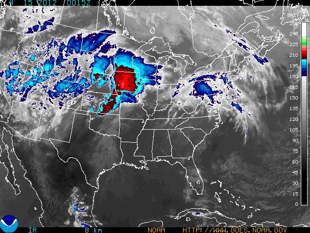
See that swirly looking area out west, looks like a badly formed hurricane?
That's your low pressure system.
Look at the “L”'s on this map:
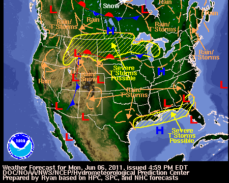
You're right near the leading edge of that low pressure front as of now, you probably were under it when the tornado's happened.
As an ATS Staff Member, I will not moderate in threads such as this where I have participated as a member.
edit on 4/14/2012 by defcon5 because: (no reason given)
The area where tornadoes were predicted is very large. It's easy enough to roughly forecast the weather a day or two in advance, and say the
condition will be right somewhere over a large area (a tornado watch). It's much harder to forecast exactly where the tornadoes will be until just
before they arrive (a tornado warning).
I read it was only 2nd time they predicted 24 hours in advanced
Look out
Look out
Came really close last year
I was bbq with grandkids and the sky went yellow like a crayon
Lucky it skipped over us cause I was dumb
I was bbq with grandkids and the sky went yellow like a crayon
Lucky it skipped over us cause I was dumb
Originally posted by Uncinus
The area where tornadoes were predicted is very large. It's easy enough to roughly forecast the weather a day or two in advance, and say the condition will be right somewhere over a large area (a tornado watch). It's much harder to forecast exactly where the tornadoes will be until just before they arrive (a tornado warning).
I see you live in the tornado capitol of the west coast LA? Tornadoes are NOT forecastable within a few days, PERIOD. We get plenty of them in the mid west and trust me, they come out of nowhere.
reply to post by AllUrChips
"PERIOD"??
Really?
The Weather Channel: Forecasting Tornadoes
Tell us --- have you ever seen a weather forecast that predicted severe thunderstorms more than one day in advance???
IF you can predict thunderstorms, and see other atmospheric trends that indicate severity, then you CAN predict tornadoes as a possibility to the associated with those T-Storms.
"PERIOD"!
Tornadoes are NOT forecastable within a few days, PERIOD. We get plenty of them in the mid west and trust me, they come out of nowhere.
"PERIOD"??
Really?
The Weather Channel: Forecasting Tornadoes
Since most tornadoes are formed in conjunction with severe thunderstorms, forecasters first must determine where thunderstorms are likely to form and reach the severity necessary for tornado formation.
Tell us --- have you ever seen a weather forecast that predicted severe thunderstorms more than one day in advance???
IF you can predict thunderstorms, and see other atmospheric trends that indicate severity, then you CAN predict tornadoes as a possibility to the associated with those T-Storms.
"PERIOD"!
new topics
-
I hate dreaming
Rant: 19 minutes ago -
Is the origin for the Eye of Horus the pineal gland?
Philosophy and Metaphysics: 2 hours ago -
Man sets himself on fire outside Donald Trump trial
Mainstream News: 2 hours ago -
Biden says little kids flip him the bird all the time.
2024 Elections: 2 hours ago -
The Democrats Take Control the House - Look what happened while you were sleeping
US Political Madness: 2 hours ago -
Sheetz facing racial discrimination lawsuit for considering criminal history in hiring
Social Issues and Civil Unrest: 3 hours ago -
In an Historic First, In N Out Burger Permanently Closes a Location
Mainstream News: 4 hours ago -
MH370 Again....
Disaster Conspiracies: 5 hours ago -
Are you ready for the return of Jesus Christ? Have you been cleansed by His blood?
Religion, Faith, And Theology: 7 hours ago -
Chronological time line of open source information
History: 9 hours ago
top topics
-
In an Historic First, In N Out Burger Permanently Closes a Location
Mainstream News: 4 hours ago, 14 flags -
The Democrats Take Control the House - Look what happened while you were sleeping
US Political Madness: 2 hours ago, 9 flags -
Thousands Of Young Ukrainian Men Trying To Flee The Country To Avoid Conscription And The War
Other Current Events: 15 hours ago, 8 flags -
A man of the people
Medical Issues & Conspiracies: 10 hours ago, 8 flags -
Man sets himself on fire outside Donald Trump trial
Mainstream News: 2 hours ago, 7 flags -
Biden says little kids flip him the bird all the time.
2024 Elections: 2 hours ago, 6 flags -
4 plans of US elites to defeat Russia
New World Order: 12 hours ago, 4 flags -
Are you ready for the return of Jesus Christ? Have you been cleansed by His blood?
Religion, Faith, And Theology: 7 hours ago, 3 flags -
Is the origin for the Eye of Horus the pineal gland?
Philosophy and Metaphysics: 2 hours ago, 3 flags -
Sheetz facing racial discrimination lawsuit for considering criminal history in hiring
Social Issues and Civil Unrest: 3 hours ago, 3 flags
active topics
-
The Democrats Take Control the House - Look what happened while you were sleeping
US Political Madness • 21 • : ImagoDei -
Post A Funny (T&C Friendly) Pic Part IV: The LOL awakens!
General Chit Chat • 7126 • : imitator -
Man sets himself on fire outside Donald Trump trial
Mainstream News • 21 • : caterpillage -
Biden says little kids flip him the bird all the time.
2024 Elections • 10 • : imitator -
I hate dreaming
Rant • 1 • : nugget1 -
Thousands Of Young Ukrainian Men Trying To Flee The Country To Avoid Conscription And The War
Other Current Events • 28 • : Xtrozero -
12 jurors selected in Trump criminal trial
US Political Madness • 89 • : ImagoDei -
Is the origin for the Eye of Horus the pineal gland?
Philosophy and Metaphysics • 4 • : JoelSnape -
Fossils in Greece Suggest Human Ancestors Evolved in Europe, Not Africa
Origins and Creationism • 72 • : Xtrozero -
MH370 Again....
Disaster Conspiracies • 8 • : Lazy88