It looks like you're using an Ad Blocker.
Please white-list or disable AboveTopSecret.com in your ad-blocking tool.
Thank you.
Some features of ATS will be disabled while you continue to use an ad-blocker.

Taking photos of Vandenberg AFB runway and launch sites?
page: 10
share:
I am going on a trip to CA this month and I want to visit the Vandenberg AFB site to take some pics and then edit it as a panoramic view image a some
of us has already done so for Groom Lake.
My relatives live close by about 40 miles away at least.
What is the best spot or view to take photos of the runway and the Delta rocket launch site?
Thanks in advance.
My relatives live close by about 40 miles away at least.
What is the best spot or view to take photos of the runway and the Delta rocket launch site?
Thanks in advance.
Originally posted by darpa999
I am going on a trip to CA this month and I want to visit the Vandenberg AFB site to take some pics and then edit it as a panoramic view image a some of us has already done so for Groom Lake.
My relatives live close by about 40 miles away at least.
What is the best spot or view to take photos of the runway and the Delta rocket launch site?
Thanks in advance.
Good luck with that...u going to need it!
I never got postcard from Guantanamo,i can give u my address just in case
reply to post by darpa999
Brian Webb runs a website about KVBG:
www.spacearchive.info...
However, his website is aimed at shooting launches, not photographing the base.
The key is to find some public land with elevation. In the desert, finding public land is easy. On the California coast, much of the land with elevation is private. There there is the issue of trees.
I looked at Google Earth and thought this might be a suitable location to shoot from:
34°50'23.41"N 120°33'23.45"W
But without knowing the area, it is hard to predict where the public land is located. Also note that KVBG is often fogged in. Generally that doesn't prevent launches, but sure makes photography tough.
I just wanted to take pics so I can look at it and say that I was here. But if its private then I do not want to take the risk of being interogated
and end up being dragged into a black umarked SUV with a group of men in black suits and shades
I lived on Vandenberg Air Force Base for 6 months...
I got to watch the launches live on base and super close......it was awesome!
I dont know the area real well, so I cant give you any tips on where a civilian can watch them......sorry :/
Hope you get to...its super fun!
ETA....
I know there are some public beaches in Lompoc that you could visit and probalby get a view of a launch...Lompoc is next to Vandenberg.....even a beach near the prison - which is across the street from VAFB...
Lompoc Public Beaches - HERE
edit on April 14th 2012 by greeneyedleo because: (no
reason given)
reply to post by greeneyedleo
For some kind of launches, Brian's website suggests to use the beach. For others, they use Santa Ynez.
If you go to watch a launch, it is best to read up on the rocket used. The rocket launch I watched was quite timid. But KVBG does launch the Atlas V. The most impressive launch I ever saw had to be the one of the Space Shuttle missions.
reply to post by darpa999
You need to scout out a spot to take the shots. There could be public land nearby. It is hard to tell from Google Earth what is public and what is private.
For my money, Point Mugu would be a more interesting visit unless you knew a launch was about to take place at KVBG.
34° 7'14.41"N 119° 7'22.40"W
A bit further down the coast from KVBG.
The famed N105TB aircraft, a Groom Lake visitor, also does work for the Navy at Point Mugu.
The next KVBG launch is May 16 per
www.spacearchive.info...
Webb has a mailing list if you want to get noticed on KVBG launches. Even if you are not going to attend a launch, knowing when a launch is done comes in handy since they are often reported as UFOs.
This is a launch I spotted from well inland. Actually east of the NTTR.
www.lazygranch.com...
You may consider subscribing to the launch alert e-mails at the following site:
Vandenberg AFB Launch Alerts
They seem to put out a weekly message and include many of the upcoming launches a few months out. I recall they tracked other launch times at Kennedy Space Center and Wallops Flight Facility.
Vandenberg AFB Launch Alerts
They seem to put out a weekly message and include many of the upcoming launches a few months out. I recall they tracked other launch times at Kennedy Space Center and Wallops Flight Facility.
reply to post by TAGBOARD
That is the newsletter from the spacearchive website. The newsletter assumes you also know about the spacearchive website since that is where the directions to viewing locations are given. I suggest checking accuweather too given the coastal weather conditions. Remember, fog on the base is fine for launches if it is clear above the bank. If you go to the Santa Ynez site and have good ears, you can hear the countdown. KBVG has a private road that goes to their launch observation facility. The count you hear is from a bullhorn at the observatory.
www.spacearchive.info...
reply to post by darpa999
I'm in shock. A youtube video done on a tripod! At first I thought the video was a series of stills. There are videos of it chasing the SU-27, which as I mentioned in the other thread was just flying around the range last week. When I photographed the SU-27, I was so excited I forgot to photograph the chase plane. It could have been N105TB. Who knows. The latest sighting also had chase, but F-16.
This is an old log of N105TB landing at KDRI (Desert Rock).
I presume Nellis has a fit with the Passur plane tracking website. I've tracked a few planes going into the range with it. At one time the Passur service was cut, but just to the public. I figured out a back door to produce some of the tracks. Note that McCarran is one of the few urban airports without noise monitoring websites. This is presumably to prevent a visiting plane from being tracked.
www.inplanesight.org...
I have about half a dozen more tracking websites to add. I also have a few more FAA records to upload that were donated to the website. You can look at what I have thus far here:
www.inplanesight.org...
One of the CIA registered planes has a fake signature on the documents. If you google around a bit, there are photos of the CIA agents that flew on rendition aircraft, fake names of course. The entertaining thing is post 9/11, many countries are adding biometrics to passports including facial recognition. It is getting harder for the agency to do mischief.
Passur was great and then I noticed they had KLAX Los Angeles airport taken off as well.
Also, one of the best tracking sites are www.flightradar24.com which gives you up to the SECOND real time tracking. These other sites tends to give a 10 minute delay in updating the aircraft data.
The cons about Flightradar24, is that mostly transmit their ABS data over Europe. But here is the USA based one. www.planefinder.net
The following is my opinion as a member participating in this discussion.
I think right next to the sign would be a good place:
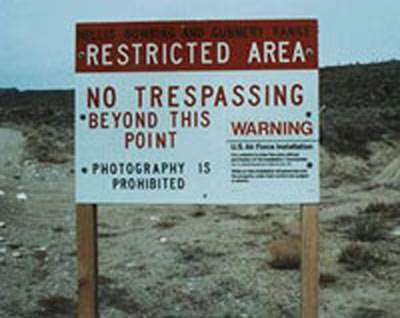
As an ATS Staff Member, I will not moderate in threads such as this where I have participated as a member.
reply to post by darpa999
Passur was a precise MLAT network supplemented with the FAA feed to identify the planes. The display features weren't so great, but the basic scheme worked very well. There was no way to get a trail from passur, so I had a macro to stack images. Sometimes I set up my PC to record the display window as an AVI, then stacked those frames.
The webtrack sites are hit or miss. There doesn't seem to be a consistency on how they are filtered by the FAA, or perhaps how webtrack filters the feed. In socal and norcal, there is much overlap between airport surveillance, so you can check a few feeds to find the plane. If you got a mode-s hit (but not ADSB), you try to find it in the likely airspace on the tracker site. Once in a while webtrack locations are just totally wrong, like they latched onto the wrong plane.
If you have a mode-s box and contribute, you can get much of the data off of
live-mode-s.info
It has the regular mode-s and ADSB. At the moment, there is a reliable Vegas box on the network.
Plane Plotter can in theory track planes without mode-s using MLAT, but the program is really crap. When the program isn't crashed or just plain out to lunch (appears to be alive but not feeding data), the MLAT is good to maybe 3 miles at best. More like 5 miles. Save your money. I've never been a fan of one-person software companies. This COAA is the worst I ever encountered.
The next generation Beast will have real MLAT built in using GPS timing and won't need junk like planeplotter to mlat.
www.modesbeast.com...
The designer is German, so the English is a bit choppy. But the engineering is good.
new topics
-
Las Vegas UFO Spotting Teen Traumatized by Demon Creature in Backyard
Aliens and UFOs: 2 hours ago -
2024 Pigeon Forge Rod Run - On the Strip (Video made for you)
Automotive Discussion: 3 hours ago -
Gaza Terrorists Attack US Humanitarian Pier During Construction
Middle East Issues: 3 hours ago -
The functionality of boldening and italics is clunky and no post char limit warning?
ATS Freshman's Forum: 4 hours ago -
Meadows, Giuliani Among 11 Indicted in Arizona in Latest 2020 Election Subversion Case
Mainstream News: 5 hours ago -
Massachusetts Drag Queen Leads Young Kids in Free Palestine Chant
Social Issues and Civil Unrest: 5 hours ago -
Weinstein's conviction overturned
Mainstream News: 7 hours ago -
Supreme Court Oral Arguments 4.25.2024 - Are PRESIDENTS IMMUNE From Later Being Prosecuted.
Above Politics: 8 hours ago -
Krystalnacht on today's most elite Universities?
Social Issues and Civil Unrest: 8 hours ago -
Chris Christie Wishes Death Upon Trump and Ramaswamy
Politicians & People: 9 hours ago
top topics
-
Krystalnacht on today's most elite Universities?
Social Issues and Civil Unrest: 8 hours ago, 9 flags -
Supreme Court Oral Arguments 4.25.2024 - Are PRESIDENTS IMMUNE From Later Being Prosecuted.
Above Politics: 8 hours ago, 8 flags -
Weinstein's conviction overturned
Mainstream News: 7 hours ago, 7 flags -
University of Texas Instantly Shuts Down Anti Israel Protests
Education and Media: 11 hours ago, 6 flags -
Meadows, Giuliani Among 11 Indicted in Arizona in Latest 2020 Election Subversion Case
Mainstream News: 5 hours ago, 5 flags -
Gaza Terrorists Attack US Humanitarian Pier During Construction
Middle East Issues: 3 hours ago, 4 flags -
Massachusetts Drag Queen Leads Young Kids in Free Palestine Chant
Social Issues and Civil Unrest: 5 hours ago, 4 flags -
Las Vegas UFO Spotting Teen Traumatized by Demon Creature in Backyard
Aliens and UFOs: 2 hours ago, 3 flags -
Chris Christie Wishes Death Upon Trump and Ramaswamy
Politicians & People: 9 hours ago, 2 flags -
Any one suspicious of fever promotions events, major investor Goldman Sachs card only.
The Gray Area: 13 hours ago, 2 flags
active topics
-
Las Vegas UFO Spotting Teen Traumatized by Demon Creature in Backyard
Aliens and UFOs • 7 • : rickymouse -
Meadows, Giuliani Among 11 Indicted in Arizona in Latest 2020 Election Subversion Case
Mainstream News • 10 • : chr0naut -
Supreme Court Oral Arguments 4.25.2024 - Are PRESIDENTS IMMUNE From Later Being Prosecuted.
Above Politics • 75 • : Vermilion -
University student disciplined after saying veganism is wrong and gender fluidity is stupid
Education and Media • 50 • : watchitburn -
VP's Secret Service agent brawls with other agents at Andrews
Mainstream News • 55 • : CarlLaFong -
Cats Used as Live Bait to Train Ferocious Pitbulls in Illegal NYC Dogfighting
Social Issues and Civil Unrest • 23 • : Ravenwatcher -
-@TH3WH17ERABB17- -Q- ---TIME TO SHOW THE WORLD--- -Part- --44--
Dissecting Disinformation • 680 • : 777Vader -
Is there a hole at the North Pole?
ATS Skunk Works • 40 • : Oldcarpy2 -
Fossils in Greece Suggest Human Ancestors Evolved in Europe, Not Africa
Origins and Creationism • 89 • : whereislogic -
University of Texas Instantly Shuts Down Anti Israel Protests
Education and Media • 197 • : NorthOS
0