It looks like you're using an Ad Blocker.
Please white-list or disable AboveTopSecret.com in your ad-blocking tool.
Thank you.
Some features of ATS will be disabled while you continue to use an ad-blocker.

6.2 off Oregon coast (updated to a 5.9) 7.0 in mexico right after
page: 1share:
Just saw it on fox news. looks like it was changed to a 5.9
Earthquake Details
This event has been reviewed by a seismologist.
Magnitude
5.9
Date-Time
Wednesday, April 11, 2012 at 22:41:47 UTC
Wednesday, April 11, 2012 at 01:41:47 PM at epicenter
Location
43.593°N, 127.557°W
Depth
10.2 km (6.3 miles)
Region
OFF THE COAST OF OREGON
Distances
260 km (161 miles) WNW (283°) from Bandon, OR
263 km (164 miles) W (277°) from Barview, OR
265 km (165 miles) WNW (292°) from Port Orford, OR
342 km (213 miles) NW (308°) from Crescent City, CA
445 km (276 miles) WSW (243°) from Portland, OR
Location Uncertainty
horizontal +/- 15.8 km (9.8 miles); depth +/- 2.8 km (1.7 miles)
Parameters
NST=455, Nph=456, Dmin=273.8 km, Rmss=0.97 sec, Gp= 94°,
M-type=regional moment magnitude (Mw), Version=A
Source
Magnitude: NOAA West Coast and Alaska Tsunami Warning Center, Palmer, Alaska, USA
Location: USGS NEIC (WDCS-D)
Event ID
usc00090yf
Did you feel it? Report shaking and damage at your location. You can also view a map displaying accumulated data from your report and others.
Preliminary Earthquake Report
U.S. Geological Survey, National Earthquake Information Center:
World Data Center for Seismology, Denver
usgs.com
breaking news on top says 6.2
7.0 mexico
Magnitude 7.0 - MICHOACAN, MEXICO
2012 April 11 22:55:16 UTC
Details
Maps
Tsunami
Earthquake Details
This event has been reviewed by a seismologist.
Magnitude
7.0
Date-Time
Wednesday, April 11, 2012 at 22:55:16 UTC
Wednesday, April 11, 2012 at 05:55:16 PM at epicenter
Location
18.390°N, 102.652°W
Depth
65.6 km (40.8 miles)
Region
MICHOACAN, MEXICO
Distances
51 km (32 miles) SW (231°) from La Mira, Michoacán, Mexico
61 km (38 miles) NW (312°) from Las Guacamayas, Michoacán, Mexico
64 km (40 miles) NW (316°) from La Orilla, Michoacán, Mexico
130 km (81 miles) SSW (208°) from Uruapan, Michoacán, Mexico
336 km (209 miles) WNW (301°) from Acapulco, Guerrero, Mexico
Location Uncertainty
horizontal +/- 16.7 km (10.4 miles); depth +/- 12 km (7.5 miles)
Parameters
NST=404, Nph=404, Dmin=210.4 km, Rmss=0.87 sec, Gp= 72°,
M-type=regional moment magnitude (Mw), Version=A
Source
Magnitude: NOAA, Pacific Tsunami Warning Center, Honolulu, Hawaii
Location: USGS NEIC (WDCS-D)
Event ID
usc00090z0
fox news on mexico earth quake
Earthquake Details
This event has been reviewed by a seismologist.
Magnitude
5.9
Date-Time
Wednesday, April 11, 2012 at 22:41:47 UTC
Wednesday, April 11, 2012 at 01:41:47 PM at epicenter
Location
43.593°N, 127.557°W
Depth
10.2 km (6.3 miles)
Region
OFF THE COAST OF OREGON
Distances
260 km (161 miles) WNW (283°) from Bandon, OR
263 km (164 miles) W (277°) from Barview, OR
265 km (165 miles) WNW (292°) from Port Orford, OR
342 km (213 miles) NW (308°) from Crescent City, CA
445 km (276 miles) WSW (243°) from Portland, OR
Location Uncertainty
horizontal +/- 15.8 km (9.8 miles); depth +/- 2.8 km (1.7 miles)
Parameters
NST=455, Nph=456, Dmin=273.8 km, Rmss=0.97 sec, Gp= 94°,
M-type=regional moment magnitude (Mw), Version=A
Source
Magnitude: NOAA West Coast and Alaska Tsunami Warning Center, Palmer, Alaska, USA
Location: USGS NEIC (WDCS-D)
Event ID
usc00090yf
Did you feel it? Report shaking and damage at your location. You can also view a map displaying accumulated data from your report and others.
Preliminary Earthquake Report
U.S. Geological Survey, National Earthquake Information Center:
World Data Center for Seismology, Denver
usgs.com
breaking news on top says 6.2
7.0 mexico
Magnitude 7.0 - MICHOACAN, MEXICO
2012 April 11 22:55:16 UTC
Details
Maps
Tsunami
Earthquake Details
This event has been reviewed by a seismologist.
Magnitude
7.0
Date-Time
Wednesday, April 11, 2012 at 22:55:16 UTC
Wednesday, April 11, 2012 at 05:55:16 PM at epicenter
Location
18.390°N, 102.652°W
Depth
65.6 km (40.8 miles)
Region
MICHOACAN, MEXICO
Distances
51 km (32 miles) SW (231°) from La Mira, Michoacán, Mexico
61 km (38 miles) NW (312°) from Las Guacamayas, Michoacán, Mexico
64 km (40 miles) NW (316°) from La Orilla, Michoacán, Mexico
130 km (81 miles) SSW (208°) from Uruapan, Michoacán, Mexico
336 km (209 miles) WNW (301°) from Acapulco, Guerrero, Mexico
Location Uncertainty
horizontal +/- 16.7 km (10.4 miles); depth +/- 12 km (7.5 miles)
Parameters
NST=404, Nph=404, Dmin=210.4 km, Rmss=0.87 sec, Gp= 72°,
M-type=regional moment magnitude (Mw), Version=A
Source
Magnitude: NOAA, Pacific Tsunami Warning Center, Honolulu, Hawaii
Location: USGS NEIC (WDCS-D)
Event ID
usc00090z0
edit on 11-4-2012 by KingJod because: (no reason given)
fox news on mexico earth quake
edit on
11-4-2012 by KingJod because: (no reason given)
I was looking at that and went to zoom in and there was a 7.0 in Mexico also. (60 km) depth.
edit on 11-4-2012 by Yahm16 because: (no reason
given)
Yea, Cali. seems like the middle man too, and honestly... it's only a matter of time.
That in addition to the one in Mexico makes me uneasy.
I hope this isn't a foreshock.
Scary stuff.
Question: What does the depth of the quake have to do with potential damage? I don't understand.
I hope this isn't a foreshock.
Scary stuff.
Question: What does the depth of the quake have to do with potential damage? I don't understand.
edit on 11-4-2012 by grumpydaysleeper because:
asked a question
Still nothing on the two North American Quakes on the big 3 News Networks only the Zimmerman being charge story as of now....
reply to post by usaman1983
Fox did have it on there breaking news on top, but no new information.
fox has something on mexico
Fox did have it on there breaking news on top, but no new information.
fox has something on mexico
edit on
11-4-2012 by KingJod because: (no reason given)
This is a lot of activity. Being in SoCal, I'm hoping there's no "activity" centered between these two any time soon.
Originally posted by grumpydaysleeper
That in addition to the one in Mexico makes me uneasy.
I hope this isn't a foreshock.
Scary stuff.
Question: What does the depth of the quake have to do with potential damage? I don't understand.edit on 11-4-2012 by grumpydaysleeper because: asked a question
Im no expert but im pretty sure the deeper the water, the more water is displaced, leading to bigger tsunamis.
reply to post by grumpydaysleeper
Well the depth has a lot to do with the potential damage of an earthquake. It's basically like this.
0-70 km depth is classified as a Shallow earthquake - Meaning it's more likely to be felt or cause damage.
70-300 km depth is classified as a Intermediate earthquake - Meaning it could be felt, and most likely no damage
300-700 km depth is classified as a Deep earthquake - Basically meaning that nothing should happen but there is a very slim chance.
The more shallow the quake is the more damage it causes of course because it is closer to the surface of the earth and the S and P waves get there faster, and are more destructive. Correct me if I'm wrong though D:
Mexico quake is a shallow one......Was it above land or in the water?
Originally posted by GuidedKill
Mexico quake is a shallow one......Was it above land or in the water?
Looking at the map, i would appear land.
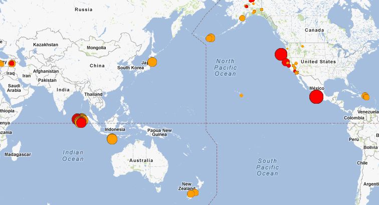
West coast kinda busy today, eh?
quakes.globalincidentmap.com...
Originally posted by amongus
Big earthquakes NOT on the rise, FOX
But it sure seems like they are....
It seems like there are because there are more of us constantly monitoring these quakes and posting about them on online forums.
reply to post by KingJod
I used to live in the area, and Bandon-by-sea itself got wiped out by a tsunami a century or so ago?
Best to all my west coast friends and all I do not know that reside there; this actually happens more frequently than more people expect. I miss my friend in Grants Pass OR (passed)--an older vet from Vietnam who was spot on in predicting the EQs at least 24 hours+ in advance....despite being a hundred miles inland
earthquake 3d is nice software program to use, they have free and pro version...can have it beep on EQ and view in a variety of ways the whole planet
in 3d
California from Baja up, gets unusual amount of quakes daily all the way up to Alaska, maybe the most on the planet per day, considering the factors of, magnitude X amount, as the frequency is so often, you would think being there, would be like a constant vibration and reverberation ...
California from Baja up, gets unusual amount of quakes daily all the way up to Alaska, maybe the most on the planet per day, considering the factors of, magnitude X amount, as the frequency is so often, you would think being there, would be like a constant vibration and reverberation ...
Originally posted by stanguilles7
Originally posted by amongus
Big earthquakes NOT on the rise, FOX
But it sure seems like they are....
It seems like there are because there are more of us constantly monitoring these quakes and posting about them on online forums.
Or its because they are happening more frequently. 2nd line.
Update time = Wed Apr 11 23:31:31 UTC 2012
MAG UTC DATE-TIME
y/m/d h:m:s LAT
deg LON
deg DEPTH
km Region
MAP 7.0 2012/04/11 22:55:17 18.390 -102.652 65.6 MICHOACAN, MEXICO
MAP 5.4 2012/04/11 22:51:59 2.897 89.597 14.7 NORTH INDIAN OCEAN
MAP 5.9 2012/04/11 22:41:47 43.593 -127.557 10.2 OFF THE COAST OF OREGON
MAP 4.9 2012/04/11 22:35:34 2.488 90.185 14.8 OFF THE WEST COAST OF NORTHERN SUMATRA
MAP 5.0 2012/04/11 22:15:26 0.514 92.443 13.8 OFF THE WEST COAST OF NORTHERN SUMATRA
MAP 4.2 2012/04/11 22:02:50 51.508 -176.673 35.6 ANDREANOF ISLANDS, ALEUTIAN IS., ALASKA
MAP 3.0 2012/04/11 21:53:23 59.218 -154.654 197.9 SOUTHERN ALASKA
MAP 5.0 2012/04/11 21:36:09 1.787 90.927 15.0 NORTH INDIAN OCEAN
MAP 3.2 2012/04/11 21:23:40 51.251 -178.168 18.3 ANDREANOF ISLANDS, ALEUTIAN IS., ALASKA
MAP 4.7 2012/04/11 21:02:50 0.717 92.407 15.2 OFF THE WEST COAST OF NORTHERN SUMATRA
MAP 2.9 2012/04/11 20:50:59 18.088 -67.480 11.6 MONA PASSAGE, PUERTO RICO
MAP 3.6 2012/04/11 20:03:14 19.075 -68.615 165.3 DOMINICAN REPUBLIC REGION
MAP 5.5 2012/04/11 19:04:20 1.202 92.090 10.3 OFF THE WEST COAST OF NORTHERN SUMATRA
MAP 5.4 2012/04/11 18:54:46 2.496 92.712 14.3 OFF THE WEST COAST OF NORTHERN SUMATRA
MAP 2.5 2012/04/11 16:32:14 18.731 -68.225 104.0 DOMINICAN REPUBLIC REGION
MAP 5.1 2012/04/11 16:04:24 3.426 92.860 10.8 OFF THE WEST COAST OF NORTHERN SUMATRA
MAP 5.1 2012/04/11 15:46:53 2.987 92.249 21.6 OFF THE WEST COAST OF NORTHERN SUMATRA
MAP 5.0 2012/04/11 15:09:26 2.969 90.062 13.1 OFF THE WEST COAST OF NORTHERN SUMATRA
MAP 5.3 2012/04/11 14:54:29 1.336 91.841 11.9 NORTH INDIAN OCEAN
MAP 5.3 2012/04/11 14:34:19 1.504 90.894 14.4 NORTH INDIAN OCEAN
MAP 5.0 2012/04/11 14:26:27 2.287 92.385 9.4 OFF THE WEST COAST OF NORTHERN SUMATRA
MAP 5.0 2012/04/11 14:18:45 2.569 92.296 10.3 OFF THE WEST COAST OF NORTHERN SUMATRA
MAP 5.2 2012/04/11 14:08:41 1.147 92.158 9.6 OFF THE WEST COAST OF NORTHERN SUMATRA
MAP 5.5 2012/04/11 13:58:07 1.493 90.889 13.7 NORTH INDIAN OCEAN
MAP 5.3 2012/04/11 13:42:40 2.159 93.597 11.0 OFF THE WEST COAST OF NORTHERN SUMATRA
MAP 4.6 2012/04/11 13:39:56 0.600 91.889 10.0 NORTH INDIAN OCEAN
MAP 4.6 2012/04/11 13:32:35 1.905 89.578 10.0 NORTH INDIAN OCEAN
MAP 5.0 2012/04/11 13:19:38 2.345 90.302 20.4 OFF THE WEST COAST OF NORTHERN SUMATRA
MAP 5.1 2012/04/11 13:15:28 4.614 90.764 5.3 OFF THE WEST COAST OF NORTHERN SUMATRA
MAP 4.8 2012/04/11 13:12:05 -18.479 -175.498 245.2 TONGA
MAP 4.5 2012/04/11 13:10:07 0.890 92.382 10.0 OFF THE WEST COAST OF NORTHERN SUMATRA
MAP 3.4 2012/04/11 13:06:31 62.560 -150.133 174.1 CENTRAL ALASKA
MAP 5.1 2012/04/11 12:37:48 2.528 92.602 10.0 OFF THE WEST COAST OF NORTHERN SUMATRA
MAP 5.1 2012/04/11 12:21:58 3.136 92.775 9.9 OFF THE WEST COAST OF NORTHERN SUMATRA
MAP 5.1 2012/04/11 12:10:53 1.385 92.639 10.4 OFF THE WEST COAST OF NORTHERN SUMATRA
MAP 5.7 2012/04/11 11:53:37 2.929 89.534 14.9 NORTH INDIAN OCEAN
MAP 5.3 2012/04/11 11:52:29 0.989 91.942 14.9 NORTH INDIAN OCEAN
MAP 5.4 2012/04/11 11:34:02 0.743 92.865 15.5 OFF THE WEST COAST OF NORTHERN SUMATRA
MAP 5.4 2012/04/11 11:29:00 -56.847 -27.966 259.0 SOUTH SANDWICH ISLANDS REGION
MAP 2.7 2012/04/11 11:08:39 64.893 -148.948 5.8 CENTRAL ALASKA
MAP 8.2 2012/04/11 10:43:09 0.773 92.452 16.4 OFF THE WEST COAST OF NORTHERN SUMATRA
MAP 2.6 2012/04/11 10:42:48 33.491 -116.425 10.6 SOUTHERN CALIFORNIA
MAP 5.4 2012/04/11 10:36:55 1.072 91.943 15.5 NORTH INDIAN OCEAN
MAP 2.8 2012/04/11 10:22:14 64.896 -148.880 7.1 CENTRAL ALASKA
MAP 5.4 2012/04/11 10:21:16 2.833 92.476 14.8 OFF THE WEST COAST OF NORTHERN SUMATRA
MAP 5.1 2012/04/11 10:08:30 2.646 90.084 16.1 OFF THE WEST COAST OF NORTHERN SUMATRA
MAP 5.3 2012/04/11 10:01:20 2.499 90.365 20.0 OFF THE WEST COAST OF NORTHERN SUMATRA
MAP 5.3 2012/04/11 09:51:42 2.510 90.316 20.0 OFF THE WEST COAST OF NORTHERN SUMATRA
MAP 2.9 2012/04/11 09:40:57 60.098 -152.831 103.8 SOUTHERN ALASKA
MAP 3.2 2012/04/11 09:30:27 64.910 -148.934 13.9 CENTRAL ALASKA
MAP 6.0 2012/04/11 09:27:57 1.281 91.731 9.8 NORTH INDIAN OCEAN
MAP 2.9 2012/04/11 09:26:11 64.990 -148.887 27.8 CENTRAL ALASKA
MAP 3.8 2012/04/11 09:21:58 64.904 -148.888 20.7 CENTRAL ALASKA
MAP 5.5 2012/04/11 09:00:13 51.518 -176.312 56.5 ANDREANOF ISLANDS, ALEUTIAN IS., ALASKA
MAP 8.6 2012/04/11 08:38:37 2.311 93.063 22.9 OFF THE WEST COAST OF NORTHERN SUMATRA
MAP 5.3 2012/04/11 07:41:46 -6.227 130.158 132.2 BANDA SEA
MAP 4.4 2012/04/11 06:54:39 -22.748 -66.387 226.3 JUJUY, ARGENTINA
MAP 2.9 2012/04/11 06:41:28 63.599 -151.404 2.9 CENTRAL ALASKA
MAP 5.1 2012/04/11 05:44:42 -16.900 -14.406 10.5 SOUTHERN MID-ATLANTIC RIDGE
MAP 5.2 2012/04/11 04:53:26 -16.822 -14.440 9.7 SOUTHERN MID-ATLANTIC RIDGE
MAP 2.6 2012/04/11 03:18:48 33.774 -116.112 8.6 SOUTHERN CALIFORNIA
MAP 2.6 2012/04/11 02:21:41 62.034 -151.695 15.3 CENTRAL ALASKA
MAP 4.5 2012/04/11 01:21:18 42.200 87.908 31.7 NORTHERN XINJIANG, CHINA
MAP 4.5 2012/04/11 00:34:13 -23.896 -114.819 10.0 EASTER ISLAND REGION
edit on 11-4-2012 by kennvideo because: (no reason given)
new topics
-
God's Righteousness is Greater than Our Wrath
Religion, Faith, And Theology: 3 hours ago -
Electrical tricks for saving money
Education and Media: 6 hours ago -
VP's Secret Service agent brawls with other agents at Andrews
Mainstream News: 7 hours ago -
Sunak spinning the sickness figures
Other Current Events: 8 hours ago -
Nearly 70% Of Americans Want Talks To End War In Ukraine
Political Issues: 8 hours ago -
Late Night with the Devil - a really good unusual modern horror film.
Movies: 10 hours ago -
Cats Used as Live Bait to Train Ferocious Pitbulls in Illegal NYC Dogfighting
Social Issues and Civil Unrest: 11 hours ago
top topics
-
VP's Secret Service agent brawls with other agents at Andrews
Mainstream News: 7 hours ago, 9 flags -
Cats Used as Live Bait to Train Ferocious Pitbulls in Illegal NYC Dogfighting
Social Issues and Civil Unrest: 11 hours ago, 8 flags -
Electrical tricks for saving money
Education and Media: 6 hours ago, 4 flags -
HORRIBLE !! Russian Soldier Drinking Own Urine To Survive In Battle
World War Three: 15 hours ago, 3 flags -
Nearly 70% Of Americans Want Talks To End War In Ukraine
Political Issues: 8 hours ago, 3 flags -
Sunak spinning the sickness figures
Other Current Events: 8 hours ago, 3 flags -
Late Night with the Devil - a really good unusual modern horror film.
Movies: 10 hours ago, 2 flags -
The Good News According to Jesus - Episode 1
Religion, Faith, And Theology: 13 hours ago, 1 flags -
God's Righteousness is Greater than Our Wrath
Religion, Faith, And Theology: 3 hours ago, 0 flags
active topics
-
Mood Music Part VI
Music • 3101 • : ThatSmellsStrange -
VP's Secret Service agent brawls with other agents at Andrews
Mainstream News • 41 • : ThatSmellsStrange -
HORRIBLE !! Russian Soldier Drinking Own Urine To Survive In Battle
World War Three • 32 • : DaRAGE -
New whistleblower Jason Sands speaks on Twitter Spaces last night.
Aliens and UFOs • 55 • : baablacksheep1 -
Cats Used as Live Bait to Train Ferocious Pitbulls in Illegal NYC Dogfighting
Social Issues and Civil Unrest • 20 • : Asher47 -
Nearly 70% Of Americans Want Talks To End War In Ukraine
Political Issues • 12 • : Asher47 -
Electrical tricks for saving money
Education and Media • 4 • : Lumenari -
DONALD J. TRUMP - 2024 Candidate for President - His Communications to Americans and the World.
2024 Elections • 514 • : WeMustCare -
The Acronym Game .. Pt.3
General Chit Chat • 7744 • : bally001 -
Truth Social goes public, be careful not to lose your money
Mainstream News • 128 • : Astyanax