It looks like you're using an Ad Blocker.
Please white-list or disable AboveTopSecret.com in your ad-blocking tool.
Thank you.
Some features of ATS will be disabled while you continue to use an ad-blocker.

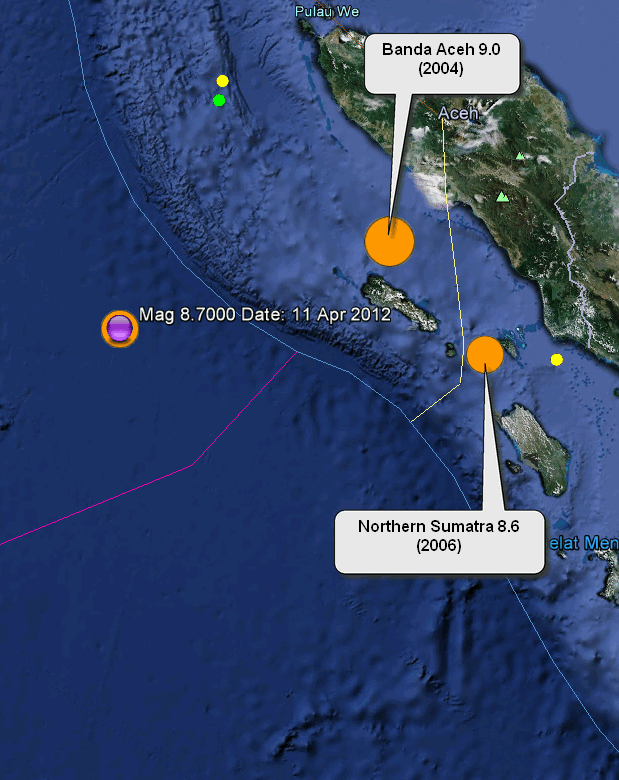
Magnitude 8.7 Sumatra
page: 1share:
Magnitude 8.7 off the west coast of northern Sumatra
Location in Google Maps
- Date-Time: Wednesday, April 11, 2012 at 08:38:30 UTC
Wednesday, April 11, 2012 at 02:38:30 PM at epicenter
- Location: 2.043°N, 92.518°E
- Depth: 33 km (20.5 miles) set by location program
- Region: OFF THE WEST COAST OF NORTHERN SUMATRA
- Distances:
495 km [308 miles] SW [219°] from Banda Aceh, Sumatra, Indonesia
1027 km [638 miles] W [263°] from KUALA LUMPUR, Malaysia
- Location Uncertainty: Error estimate not available
- Parameters: NST= 14, Nph=0, Dmin=0 km, Rmss=0 sec, Gp=198°,M-type="moment" magnitude from initial P wave (tsuboi method) (Mi/Mwp),
Version=B
- Source: NOAA Pacific Tsunami Warning Center
- Event ID: pt12102000
Derived from Data Source: USGS
Powered by QVSData
edit on 11/4/2012 by PuterMan because: Reduced to 87.
Potentially this IS tsunami event
cont
000
WEIO21 PHEB 110845
TSUIOX
TSUNAMI BULLETIN NUMBER 001
PACIFIC TSUNAMI WARNING CENTER/NOAA/NWS
ISSUED AT 0845Z 11 APR 2012
THIS BULLETIN IS FOR ALL AREAS OF THE INDIAN OCEAN.
... AN INDIAN-OCEAN-WIDE TSUNAMI WATCH IS IN EFFECT ...
A TSUNAMI WATCH IS IN EFFECT FOR
INDONESIA / INDIA / SRI LANKA / AUSTRALIA / MYANMAR / THAILAND /
MALDIVES / UNITED KINGDOM / MALAYSIA / MAURITIUS / REUNION /
SEYCHELLES / PAKISTAN / SOMALIA / OMAN / MADAGASCAR / IRAN /
UAE / YEMEN / COMORES / BANGLADESH / TANZANIA / MOZAMBIQUE /
KENYA / CROZET ISLANDS / KERGUELEN ISLANDS / SOUTH AFRICA /
SINGAPORE
THIS BULLETIN IS ISSUED AS ADVICE TO GOVERNMENT AGENCIES. ONLY
NATIONAL AND LOCAL GOVERNMENT AGENCIES HAVE THE AUTHORITY TO MAKE
DECISIONS REGARDING THE OFFICIAL STATE OF ALERT IN THEIR AREA AND
ANY ACTIONS TO BE TAKEN IN RESPONSE.
AN EARTHQUAKE HAS OCCURRED WITH THESE PRELIMINARY PARAMETERS
ORIGIN TIME - 0839Z 11 APR 2012
COORDINATES - 2.0 NORTH 92.5 EAST
LOCATION - OFF W COAST OF NORTHERN SUMATRA
MAGNITUDE - 8.7
EVALUATION
EARTHQUAKES OF THIS SIZE HAVE THE POTENTIAL TO GENERATE A
WIDESPREAD DESTRUCTIVE TSUNAMI THAT CAN AFFECT COASTLINES ACROSS
THE ENTIRE INDIAN OCEAN BASIN.
HOWEVER - IT IS NOT KNOWN THAT A TSUNAMI WAS GENERATED. THIS
WATCH IS BASED ONLY ON THE EARTHQUAKE EVALUATION. AUTHORITIES IN
THE REGION SHOULD TAKE APPROPRIATE ACTION IN RESPONSE TO THE
POSSIBILITY OF A WIDESPREAD DESTRUCTIVE TSUNAMI.
ESTIMATED INITIAL TSUNAMI WAVE ARRIVAL TIMES AT FORECAST POINTS
WITHIN THE WARNING AND WATCH AREAS ARE GIVEN BELOW. ACTUAL
ARRIVAL TIMES MAY DIFFER AND THE INITIAL WAVE MAY NOT BE THE
LARGEST. A TSUNAMI IS A SERIES OF WAVES AND THE TIME BETWEEN
SUCCESSIVE WAVES CAN BE FIVE MINUTES TO ONE HOUR.
LOCATION FORECAST POINT COORDINATES ARRIVAL TIME
-------------------------------- ------------ ------------
INDONESIA SIMEULUE 2.5N 96.0E 0921Z 11 APR
BANDA_ACEH 5.5N 95.1E 0931Z 11 APR
SIBERUT 1.5S 98.7E 0941Z 11 APR
PADANG 0.9S 100.1E 1017Z 11 APR
BENGKULU 3.9S 102.0E 1038Z 11 APR
CILACAP 7.8S 108.9E 1205Z 11 APR
BANDAR_LAMPUNG 5.7S 105.3E 1213Z 11 APR
BALI 8.7S 115.3E 1253Z 11 APR
KUPANG 10.0S 123.4E 1338Z 11 APR
BELAWAN 3.8N 98.8E 1348Z 11 APR
BALI 8.7S 115.3E 1253Z 11 APR
INDIA GREAT_NICOBAR 7.1N 93.6E 0937Z 11 APR
LITTLE_ANDAMAN 10.7N 92.3E 1016Z 11 APR
PORT_BLAIR 11.9N 92.7E 1032Z 11 APR
NORTH_ANDAMAN 13.3N 92.6E 1052Z 11 APR
CHENNAI 13.4N 80.4E 1127Z 11 APR
KAKINADA 17.2N 82.7E 1205Z 11 APR
TRIVANDRUM 8.3N 76.9E 1208Z 11 APR
MANGALORE 13.3N 74.4E 1336Z 11 APR
BOMBAY 18.8N 72.6E 1608Z 11 APR
GULF_OF_KUTCH 22.7N 68.9E 1634Z 11 APR
SRI LANKA DONDRA_HEAD 5.9N 80.6E 1039Z 11 APR
TRINCOMALEE 8.7N 81.3E 1051Z 11 APR
COLOMBO 6.9N 79.8E 1120Z 11 APR
JAFFNA 9.9N 80.0E 1231Z 11 APR
AUSTRALIA COCOS_ISLAND 12.1S 96.7E 1045Z 11 APR
NORTH_WEST_CAPE 21.5S 113.9E 1314Z 11 APR
CAPE_INSPIRATIO 25.9S 113.0E 1413Z 11 APR
PERTH 32.0S 115.3E 1420Z 11 APR
AUGUSTA 34.3S 114.7E 1440Z 11 APR
GERALDTOWN 28.6S 114.3E 1459Z 11 APR
CAPE_LEVEQUE 16.1S 122.6E 1506Z 11 APR
ESPERANCE 34.0S 121.8E 1615Z 11 APR
KINGSTON_SOUTH_ 37.0S 139.4E 1748Z 11 APR
HEARD_ISLAND 54.0S 73.5E 1802Z 11 APR
EUCLA_MOTEL 31.8S 128.9E 1836Z 11 APR
HOBART 43.3S 147.6E 1901Z 11 APR
DARWIN 12.1S 130.7E 1935Z 11 APR
MYANMAR CHEDUBA_ISLAND 18.9N 93.4E 1149Z 11 APR
CHEDUBA_ISLAND 18.9N 93.4E 1149Z 11 APR
PYINKAYAING 15.9N 94.3E 1150Z 11 APR
SITTWE 20.0N 92.9E 1226Z 11 APR
MERGUI 12.8N 98.4E 1316Z 11 APR
YANGON 16.5N 96.4E 1507Z 11 APR
cont
Continuation
THAILAND PHUKET 8.0N 98.2E 1118Z 11 APR
KO_PHRA_THONG 9.1N 98.2E 1223Z 11 APR
KO_TARUTAO 6.6N 99.6E 1256Z 11 APR
MALDIVES GAN 0.6S 73.2E 1137Z 11 APR
MINICOV 8.3N 73.0E 1210Z 11 APR
MALE 4.2N 73.6E 1211Z 11 APR
UNITED KINGDOM DIEGO_GARCIA 7.3S 72.4E 1153Z 11 APR
MALAYSIA GEORGETOWN 5.4N 100.1E 1311Z 11 APR
PORT_DICKSON 2.5N 101.7E 1810Z 11 APR
MAURITIUS PORT_LOUIS 20.0S 57.3E 1455Z 11 APR
REUNION ST_DENIS 20.8S 55.2E 1512Z 11 APR
SEYCHELLES VICTORIA 4.5S 55.6E 1516Z 11 APR
PAKISTAN GWADAR 25.1N 62.4E 1536Z 11 APR
KARACHI 24.7N 66.9E 1644Z 11 APR
SOMALIA CAPE_GUARO 11.9N 51.4E 1539Z 11 APR
HILALAYA 6.4N 49.1E 1540Z 11 APR
MOGADISHU 2.0N 45.5E 1558Z 11 APR
KAAMBOONI 1.5S 41.9E 1623Z 11 APR
OMAN MUSCAT 23.9N 58.6E 1540Z 11 APR
SALALAH 16.9N 54.1E 1547Z 11 APR
DUQM 19.7N 57.8E 1556Z 11 APR
MADAGASCAR ANTSIRANANA 12.1S 49.5E 1544Z 11 APR
TOAMASINA 17.8S 49.6E 1551Z 11 APR
MANAKARA 22.2S 48.2E 1610Z 11 APR
MAHAJANGA 15.4S 46.2E 1653Z 11 APR
CAP_STE_MARIE 25.8S 45.2E 1713Z 11 APR
TOLIARA 23.4S 43.6E 1733Z 11 APR
IRAN GAVATER 25.0N 61.3E 1546Z 11 APR
UAE FUJAIRAH 25.1N 56.4E 1621Z 11 APR
YEMEN AL_MUKALLA 14.5N 49.2E 1626Z 11 APR
ADEN 13.0N 45.2E 1726Z 11 APR
COMORES MORONI 11.6S 43.3E 1644Z 11 APR
BANGLADESH CHITTAGONG 22.7N 91.2E 1651Z 11 APR
TANZANIA LINDI 9.8S 39.9E 1659Z 11 APR
DAR_ES_SALAAM 6.7S 39.4E 1732Z 11 APR
MOZAMBIQUE CABO_DELGADO 10.7S 40.7E 1701Z 11 APR
ANGOCHE 15.5S 40.6E 1720Z 11 APR
QUELIMANE 18.0S 37.1E 1841Z 11 APR
MAPUTO 25.9S 32.8E 1959Z 11 APR
BEIRA 19.9S 35.1E 2016Z 11 APR
KENYA MOMBASA 4.0S 39.7E 1706Z 11 APR
CROZET ISLANDS CROZET_ISLANDS 46.4S 51.8E 1733Z 11 APR
KERGUELEN ISLAN PORT_AUX_FRANCA 49.0S 69.1E 1815Z 11 APR
SOUTH AFRICA PRINCE_EDWARD_I 46.6S 37.6E 1907Z 11 APR
DURBAN 29.8S 31.2E 1910Z 11 APR
PORT_ELIZABETH 33.9S 25.8E 2006Z 11 APR
CAPE_TOWN 34.1S 18.0E 2109Z 11 APR
SINGAPORE SINGAPORE 1.2N 103.8E 2351Z 11 APR
ADDITIONAL BULLETINS WILL BE ISSUED BY THE PACIFIC TSUNAMI
WARNING CENTER FOR THIS EVENT AS MORE INFORMATION
BECOMES AVAILABLE.
THE JAPAN METEOROLOGICAL AGENCY MAY ISSUE ADDITIONAL INFORMATION
FOR THIS EVENT. IN THE CASE OF CONFLICTING INFORMATION...THE
MORE CONSERVATIVE INFORMATION SHOULD BE USED FOR SAFETY.
Whoa!! That is a huge one!
Thanks for the heads up mate!
Hope everyone in the affected areas take care, and lets hope a tsunami doesn't hit.
Those I will keep an eye on, since I live there, and can see the beach. Tonight at 9 we will know.
vvv
Thanks for the heads up mate!
Hope everyone in the affected areas take care, and lets hope a tsunami doesn't hit.
SOUTH AFRICA PRINCE_EDWARD_I 46.6S 37.6E 1907Z 11 APR DURBAN 29.8S 31.2E 1910Z 11 APR PORT_ELIZABETH 33.9S 25.8E 2006Z 11 APR CAPE_TOWN 34.1S 18.0E 2109Z 11 APR
Those I will keep an eye on, since I live there, and can see the beach. Tonight at 9 we will know.
vvv
edit on 11-4-2012 by VreemdeVlieendeVoorwep because: (no reason given)
Been confirmed it's off Aceh....8.9 richter scale
Tsunami warning has been issue........
Tsunami warning has been issue........
edit on 11-4-2012 by Militarywarfare because: (no reason given)
I don't have flash player, but those that do should start streaming live cams on the coast of Indonesia for the next few hours. Starting now.
I've got Fox on in the background and it's still their silly fluff morning show. Gee.....I'm so selfish to think a NEWS channel might actually report
NEWS. I'd absolutely consider an 8.7 and possible tsunami to be newsworthy...like breaking news type. The last one like this killed a quarter million
people. Hopefully, this quake didn't shift anything serious for a wave..and most don't. So the odds are good is won't be as I understand this?
Everything is slow to pick this up.. IRIS map isn't showing it and neither are my Heliplot displays at my site or others... USGS Shakemap listing DOES show it and a couple others do. I guess time of the morning makes all the difference.
Everything is slow to pick this up.. IRIS map isn't showing it and neither are my Heliplot displays at my site or others... USGS Shakemap listing DOES show it and a couple others do. I guess time of the morning makes all the difference.
edit on 11-4-2012 by Wrabbit2000 because: (no reason
given)
Tsunami warning for Indian ocean just given on ABC news,,,,wow 8.7 is that for real !!!!!
that's pretty big.
Just read it was 7.2
that's pretty big.
Just read it was 7.2
edit on 11-4-2012 by MinMin because: (no reason given)
Timewave Zero drop?
Hope everyone is ok and the damage isn't too bad.
Hope everyone is ok and the damage isn't too bad.
Originally posted by Wrabbit2000
I've got Fox on in the background and it's still their silly fluff morning show. Gee.....I'm so selfish to think a NEWS channel might actually report NEWS. I'd absolutely consider an 8.7 and possible tsunami to be newsworthy...like breaking news type. The last one like this killed a quarter million people. Hopefully, this quake didn't shift anything serious for a wave..and most don't. So the odds are good is won't be as I understand this?
Not even closed. Around 26,000 peoples dies.
This is the relationship between this quake and the other 2 recent ones in that area (2004 and 2006)
The fact that the 9.0 that killed so many was in approx 770 metres of water and this was in around 4,300 might mitigate the damaging effect a little.
The fact that the 9.0 that killed so many was in approx 770 metres of water and this was in around 4,300 might mitigate the damaging effect a little.
edit on 11/4/2012 by PuterMan because: (no reason given)
reply to post by Militarywarfare
You are thinking of Japan my friend. Banda was indeed 250,000
Not even closed. Around 26,000 peoples dies.
You are thinking of Japan my friend. Banda was indeed 250,000
reply to post by PuterMan
source
Not good.
Lets hope things go better this time.
vvv
A giant 9.1-magnitude quake off the country on December 26, 2004, triggered a tsunami in the Indian Ocean that killed 230,000 people, nearly three-quarters of them in Aceh.
source
Not good.
Lets hope things go better this time.
vvv
Originally posted by PuterMan
reply to post by Militarywarfare
Not even closed. Around 26,000 peoples dies.
You are thinking of Japan my friend. Banda was indeed 250,000
167,000 people died and many more were injured to be more exact.
whoaa that was a fast catch.. CNN world didnt even have this up yet..
they issued a Tsunami warning, wonder if there was any?
sirens must be going off all over Asia-Pacific
they issued a Tsunami warning, wonder if there was any?
sirens must be going off all over Asia-Pacific
reply to post by VreemdeVlieendeVoorwep
See my comment above the location map. It may be the case that this is nowhere near as bad as far as the damage goes.
See my comment above the location map. It may be the case that this is nowhere near as bad as far as the damage goes.
We posted our threads whithin a few minutes of each other.. I have to head to bed though, so good to know you are up. (after 2 am my time and I
have already taken my Nyquil...)
The 2006 hit on my birthday. I'll never forget it. So many lives lost. I just watched a show on that a couple of weeks ago and I wept just as much then as the first time I watched it. I am praying they are not going through a similar nightmare right now....please God. That this one is stronger and even closer to shore...ugh, makes my stomach hurt!
ETA....think I got my dates wrong. Was the last major one 2004?? Well, doesn't matter I guess. You get my point.
edit on 11-4-2012 by
westcoast because: (no reason given)
Originally posted by PuterMan
reply to post by VreemdeVlieendeVoorwep
See my comment above the location map. It may be the case that this is nowhere near as bad as far as the damage goes.
Yes indeed, I see.
However, the deeper the quake, and the further out from the coast, would that now give the tsunami a huge run up so to speak, to buildt up and get even bigger?
Just speculating, not claiming it as fact.
vvv
new topics
-
The US Supreme Court Appears to Side With the January 6th 2021 Capitol Protestors.
Political Conspiracies: 27 minutes ago -
That which the "news" never talks about; Truth about election fraud
Mainstream News: 1 hours ago -
Biden doesnt want the votes of "Death to America" chanters
US Political Madness: 1 hours ago -
Horizon Post office scandal
Regional Politics: 2 hours ago -
Joe Biden and Donald Trump are both traitors
US Political Madness: 4 hours ago -
I'm new here. Avid conspiracy fan.
Introductions: 4 hours ago -
Denmark's Notre-Dame moment - 17th Century Borsen goes up in Flames
Mainstream News: 6 hours ago
top topics
-
Suspected Iranian agent working for Pentagon while U.S. coordinated defense of Israel
US Political Madness: 14 hours ago, 17 flags -
The Baloney aka BS Detection Kit
Social Issues and Civil Unrest: 13 hours ago, 7 flags -
That which the "news" never talks about; Truth about election fraud
Mainstream News: 1 hours ago, 6 flags -
Denmark's Notre-Dame moment - 17th Century Borsen goes up in Flames
Mainstream News: 6 hours ago, 4 flags -
How does my computer know
Education and Media: 17 hours ago, 3 flags -
Joe Biden and Donald Trump are both traitors
US Political Madness: 4 hours ago, 3 flags -
I'm new here. Avid conspiracy fan.
Introductions: 4 hours ago, 3 flags -
Biden doesnt want the votes of "Death to America" chanters
US Political Madness: 1 hours ago, 2 flags -
Horizon Post office scandal
Regional Politics: 2 hours ago, 1 flags -
The US Supreme Court Appears to Side With the January 6th 2021 Capitol Protestors.
Political Conspiracies: 27 minutes ago, 1 flags
active topics
-
It has begun... Iran begins attack on Israel, launches tons of drones towards the country
World War Three • 756 • : YourFaceAgain -
Biden doesnt want the votes of "Death to America" chanters
US Political Madness • 5 • : underpass61 -
Candidate TRUMP Now Has Crazy Judge JUAN MERCHAN After Him - The Stormy Daniels Hush-Money Case.
Political Conspiracies • 246 • : Annee -
Denmark's Notre-Dame moment - 17th Century Borsen goes up in Flames
Mainstream News • 8 • : Hecate666 -
-@TH3WH17ERABB17- -Q- ---TIME TO SHOW THE WORLD--- -Part- --44--
Dissecting Disinformation • 495 • : cherokeetroy -
NYAG Letitia James Prepares to Begin Seizing TRUMP Assets Even Though There Was No Crime.
Above Politics • 286 • : Annee -
Horizon Post office scandal
Regional Politics • 3 • : Hecate666 -
Mandela Effect - It Happened to Me!
The Gray Area • 102 • : DdPoolDude -
How does my computer know
Education and Media • 19 • : annonentity -
The US Supreme Court Appears to Side With the January 6th 2021 Capitol Protestors.
Political Conspiracies • 0 • : WeMustCare