It looks like you're using an Ad Blocker.
Please white-list or disable AboveTopSecret.com in your ad-blocking tool.
Thank you.
Some features of ATS will be disabled while you continue to use an ad-blocker.

What is this structure NASA took pics of in the Sahara?
page: 1share:

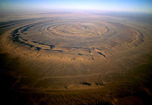
Image Credit: NASA/GSFC/MITI/ERSDAC/JAROS, and U.S./Japan ASTER Science Team
www.nasa.gov...
Richat Structure, Mauritania- This prominent circular feature in the Sahara desert of Mauritania has attracted attention since the earliest space missions because it forms a conspicuous bull’s-eye in the otherwise rather featureless expanse of the desert. Described by some as looking like an outsized fossil in the desert, the structure, which has a diameter of almost 30 miles, has become a landmark for shuttle crews. Initially interpreted as a meteorite impact structure because of its high degree of circularity, it is now thought to be merely a symmetrical uplift that has been laid bare by erosion. Paleozoic quartzites form the resistant beds outlining the structure.
More pics here-
www.theblaze.com...
Impact crater?
Natural anomaly?
Ancient strip-mining site?
reply to post by lonegurkha
I don;t know what this structure is but there has been a few reported wierd structures, one was located by google earth in the Algerian Sahara desert, www.youtube.com... and also in Mount Tassili in the Sahara are some of the first known cave paintings depicting astronaut type figures from over 30,000 years ago. Intriguing area.
I don;t know what this structure is but there has been a few reported wierd structures, one was located by google earth in the Algerian Sahara desert, www.youtube.com... and also in Mount Tassili in the Sahara are some of the first known cave paintings depicting astronaut type figures from over 30,000 years ago. Intriguing area.
If it's endogenic it could have something to do with the heat of the earth reacting with substance on the surface.
Its part of Africa and to me always looked like Atlantis. Its called Mauritania or something to that effect. when the continents were closer together
it might have resided about where the Cherokees said it was.
edit on 1-4-2012 by KingArthur because: (no reason given)
If the capitol of Atlantis had a ringed structure as they say, though I am sure there is speculation, we really don't know how that structure would
have been formed.
geology.gsapubs.org...
spiritualu.eu...:signs-of-atlantis-are-being-ignored&catid=92:atlantis
circular cuestas represented by three nested rings dipping outward
geology.gsapubs.org...
Atlantis had three rings of land surrounding the central peninsular port and capital of Atalan. A singular distinction. These three almost concentric rings....
spiritualu.eu...:signs-of-atlantis-are-being-ignored&catid=92:atlantis
edit on 1-4-2012 by
Danbones because: (no reason given)
Disregard
edit on 1-4-2012 by SilentE because: (no reason given)
Check out this site, some amazing pics of man made holes in the Earth, even the largest, but they are dwarfed by the Sahara site.
www.crookedbrains.net...
They look similar though.


and once again:
www.crookedbrains.net...
They look similar though.
and once again:
If anything was going to make me believe Atlantis was something other than a story created by Plato, this would be it.
It's amazing the beauty that can be found on earth.
It's amazing the beauty that can be found on earth.
Cool looking place, reminds me of this one in russia which is all natural, even though it dosn't look like it.
Can't remember the name of the place, so couldn't find some info on it.
But i would guess Phage know something
57°34'14.35"N 134°43'05.84"Ø
Can't remember the name of the place, so couldn't find some info on it.
But i would guess Phage know something
57°34'14.35"N 134°43'05.84"Ø
edit on 1-4-2012 by Mianeye because: (no reason given)
edit
on 1-4-2012 by Mianeye because: (no reason given)
reply to post by Phage
I bow to your wisdom Lord Warfin, I will serve you when we return victorius to planet 10.
I bow to your wisdom Lord Warfin, I will serve you when we return victorius to planet 10.
reply to post by NullVoid
That's interesting, although it does say an abundance of Quartzite, maybe it was a volcano that didn't quite make it...like a flat Yorkshire pud!
That's interesting, although it does say an abundance of Quartzite, maybe it was a volcano that didn't quite make it...like a flat Yorkshire pud!
reply to post by Signals
The Sahara used to be covered in water at some point.
I would assume water erosion would come into play.
But we always tend to pick one thing is has to be........y ?
It would be water erosion , plus the natural uplift, plus something else.
keep an open mind ... but not too open.
The Sahara used to be covered in water at some point.
I would assume water erosion would come into play.
But we always tend to pick one thing is has to be........y ?
It would be water erosion , plus the natural uplift, plus something else.
keep an open mind ... but not too open.
reply to post by Phage
It's not this, it's not that, then it must be this.
System of elimination doesn't always work.
It's circular, they didn't explain that.
It's not this, it's not that, then it must be this.
System of elimination doesn't always work.
It's circular, they didn't explain that.
new topics
-
George Knapp AMA on DI
Area 51 and other Facilities: 3 hours ago -
Not Aliens but a Nazi Occult Inspired and then Science Rendered Design.
Aliens and UFOs: 3 hours ago -
Louisiana Lawmakers Seek to Limit Public Access to Government Records
Political Issues: 6 hours ago -
The Tories may be wiped out after the Election - Serves them Right
Regional Politics: 7 hours ago -
So I saw about 30 UFOs in formation last night.
Aliens and UFOs: 9 hours ago -
Do we live in a simulation similar to The Matrix 1999?
ATS Skunk Works: 10 hours ago -
BREAKING: O’Keefe Media Uncovers who is really running the White House
US Political Madness: 10 hours ago -
Biden--My Uncle Was Eaten By Cannibals
US Political Madness: 11 hours ago -
"We're All Hamas" Heard at Columbia University Protests
Social Issues and Civil Unrest: 11 hours ago
top topics
-
BREAKING: O’Keefe Media Uncovers who is really running the White House
US Political Madness: 10 hours ago, 23 flags -
George Knapp AMA on DI
Area 51 and other Facilities: 3 hours ago, 18 flags -
Biden--My Uncle Was Eaten By Cannibals
US Political Madness: 11 hours ago, 18 flags -
African "Newcomers" Tell NYC They Don't Like the Free Food or Shelter They've Been Given
Social Issues and Civil Unrest: 16 hours ago, 12 flags -
"We're All Hamas" Heard at Columbia University Protests
Social Issues and Civil Unrest: 11 hours ago, 7 flags -
Louisiana Lawmakers Seek to Limit Public Access to Government Records
Political Issues: 6 hours ago, 7 flags -
Russian intelligence officer: explosions at defense factories in the USA and Wales may be sabotage
Weaponry: 15 hours ago, 6 flags -
So I saw about 30 UFOs in formation last night.
Aliens and UFOs: 9 hours ago, 5 flags -
The Tories may be wiped out after the Election - Serves them Right
Regional Politics: 7 hours ago, 3 flags -
Not Aliens but a Nazi Occult Inspired and then Science Rendered Design.
Aliens and UFOs: 3 hours ago, 3 flags
active topics
-
Candidate TRUMP Now Has Crazy Judge JUAN MERCHAN After Him - The Stormy Daniels Hush-Money Case.
Political Conspiracies • 373 • : WeMustCare -
MULTIPLE SKYMASTER MESSAGES GOING OUT
World War Three • 33 • : Halfswede -
-@TH3WH17ERABB17- -Q- ---TIME TO SHOW THE WORLD--- -Part- --44--
Dissecting Disinformation • 530 • : cherokeetroy -
George Knapp AMA on DI
Area 51 and other Facilities • 12 • : theshadowknows -
Not Aliens but a Nazi Occult Inspired and then Science Rendered Design.
Aliens and UFOs • 7 • : JonnyC555 -
So I saw about 30 UFOs in formation last night.
Aliens and UFOs • 19 • : rigel4 -
Mood Music Part VI
Music • 3057 • : BatCaveJoe -
The Tories may be wiped out after the Election - Serves them Right
Regional Politics • 19 • : alwaysbeenhere2 -
"We're All Hamas" Heard at Columbia University Protests
Social Issues and Civil Unrest • 125 • : KrustyKrab -
Biden--My Uncle Was Eaten By Cannibals
US Political Madness • 40 • : Kaiju666