It looks like you're using an Ad Blocker.
Please white-list or disable AboveTopSecret.com in your ad-blocking tool.
Thank you.
Some features of ATS will be disabled while you continue to use an ad-blocker.

Researchers uncover 8,000 years of human history hidden in the Middle East
page: 17
share:
How do you map the expansion of Earth's earliest civilizations? For years, researchers have tackled this daunting task on a settlement-by-settlement basis, searching for clues in mounds of earth throughout the Middle East.
Which takes a good bit of work and precious time,especially when you throw grant issues/limited windows of opportunity into the equation...Which lead them to their newly acquired methods of using multispectral imaging satellite technology.
But now, researchers have turned to satellite imagery to uncover a vast network of over 14,000 long-overlooked Mesopotamian settlements, spanning 8,000 years of ancient civilization. Their findings represent a monumental step forward for the fields of archeology and anthropology, and suggest that an aerial perspective may hold the key to unlocking the mysteries of humanity's first major settlements.
This is going to truly help furthering knowledge in the fields of archeology & anthropology,Efficiency and preservation being the key words here when it comes to their new approach.
A black and white photograph takes all of the wavelengths visible to us and blends them together. A color image shows them as combinations of red, green, and blue. Multispectral imagery... can see larger wavelengths like the near-infrared and beyond. The soils atop archaeological sites can be sensitive in both the visible and infrared ranges.
I imagine the implementation of using aerial analysis for detection of Anthrosols via multispectral satellite imagery is going to greatly improve efficiency & speed but more importantly in the words of Harvard archeologist Jason Ur and MIT computer scientist Bjoern Menze -
"[This is] a way to make sure that government planners know to take [these settlements] into consideration when making decisions about future development and modernization, which can be quite destructive to the traces of the past," says Ur. Many regions of the Middle East, he explains, have been understudied by archaeologists, which puts them at risk of being wiped from existence altogether.
Source
Any new tech or methodology that attempts to improve upon what we already have,know and use that can help increase our knowledge will be a positive addition and one more step closer in understanding of our past.
edit on 27-3-2012 by PerfectPerception because: (no reason
given)
Can someone dumb down the second picture and explain it to me? I have a theory.
Edit: most notably the weblike structure. What is that?
Edit: most notably the weblike structure. What is that?
edit on 27-3-2012 by WordsAreAvenues because: (no reason given)
reply to post by PerfectPerception
what a coincidence,I got bored and grabbed up on a course for interest and have been disappointed since I have been here.
While the early history of Mesopotamia is dominated by the history of Sumerians and Akkadians there were other very important mesopotamian civilizations emerging.....Two of these civilizations would come to dominate later Mesopotamia and these civilizations were Assyria and Babylon.....now,these text that I study from seem false for some reason.....history should be rewritten for our kids sake
edit on 27-3-2012 by
SarnholeOntarable because: (no reason given)
Originally posted by WordsAreAvenues
Can someone dumb down the second picture and explain it to me? I have a theory.
Edit: most notably the weblike structure. What is that?edit on 27-3-2012 by WordsAreAvenues because: (no reason given)
I will assume that the second picture you are referring to is an example of the multispectral satellite imagery tech. these researchers are applying for their studies.
Multi-spectral imagery, explains Ur, is useful for distinguishing different wavelengths of electromagnetic radiation, including those wavelengths that our eye's can't see
From what I have gathered it is a image possibly representing the anthrosol via different wave lengths of electromagnetic radiation.
Here,check this out and I hope this helps
A multispectral image is one that captures image data at specific frequencies across the electromagnetic spectrum. The wavelengths may be separated by filters or by the use of instruments that are sensitive to particular wavelengths, including light from frequencies beyond the visible light range, such as infrared. Spectral imaging can allow extraction of additional information the human eye fails to capture with its receptors for red, green and blue. It was originally developed for space-based imaging.
Multispectral images are the main type of images acquired by remote sensing (RS) radiometers. Dividing the spectrum into many bands [snip]
This technology has also assisted in the interpretation of ancient papyri, such as those found at Herculaneum, by imaging the fragments in the infrared range (1000 nm). Often, the text on the documents appears to be as black ink on black paper to the naked eye. At 1000 nm, the difference in light reflectivity makes the text clearly readable. It has also been used to image the Archimedes palimpsest by imaging the parchment leaves in bandwidths from 365-870 nm, and then using advanced digital image processing techniques to reveal the undertext of Archimedes work.
The availability of wavelengths for remote sensing and imaging is limited by the infrared window and the optical window.
Spectral band usage:
The wavelengths are approximate; exact values depend on the particular satellite's instruments:
Blue- 450-515..520 nm, is used for atmospheric and deep water imaging, and can reach within 150 feet (50 m) deep in clear water.
Green- 515..520-590..600 nm, is used for imaging of vegetation and deep water structures, up to 90 feet (30 m) in clear water.
Red- 600..630-680..690 nm, is used for imaging of man-made objects, in water up to 30 feet (9 m) deep, soil, and vegetation.
Near infrared- 750-900 nm, is used primarily for imaging of vegetation.
Mid-infrared-1550-1750 nm, is used for imaging vegetation, soil moisture content, and some forest fires.
Mid-infrared- 2080-2350 nm, is used for imaging soil, moisture, geological features, silicates, clays, and fires.
Thermal infrared-10400-12500 nm, uses emitted radiation instead of reflected, for imaging of geological structures, thermal differences in water currents, fires, and for night studies.
Radar and related technologies are useful for mapping terrain and for detecting various objects.
Source
Do these images remind you of Ley Lines and such?
does this image

remind you of these images...


These are images taken from the following link:
Earth's Grid Systems
Science and Pseudoscience
www.crystalinks.com...
Now the question...
Is there such a thing as this Energy Grid?
Is it possible that Civilization and the Evolution of Man follow these grids?
Is it possible that these grids are responsible for the seemingly similar types of ancient knowledge, religions, practices, and beliefs being spread around the world could have been spread via a collective consciousness that follows these lines?
does this image
remind you of these images...
These are images taken from the following link:
Earth's Grid Systems
Science and Pseudoscience
www.crystalinks.com...
Planetary Energetic Grid Theory falls under the heading of pseudoscience. It operates through geometric patterns called Sacred Geometry. Grids meet at various intersecting points forming a grid or matrix. This is equivalent to the acupressure points on our bodies. These grid points can be found at some of the strongest power places on the planet.
Plato recognized grids and their patterns, devising a theory that the Earth's basic structure evolved from a simple geometric shapes to more complex ones. These shapes became known as platonic solids: cube (4), tetrahedron (3), octahedron (8), dodecahedron (12), icosahedron(20). In Timeaus, Plato associated each shape with one of the elements, earth, fire, air, ether, and water. The Earth's energy grids, from the beginnings of its evolutionary course, has evolved through each of these shapes to what it is today. Each shape, superimposed, one upon the other to create a kind of all encompassing energy field that is the very basis of Earth holding it all together.
Now the question...
Is there such a thing as this Energy Grid?
Is it possible that Civilization and the Evolution of Man follow these grids?
Is it possible that these grids are responsible for the seemingly similar types of ancient knowledge, religions, practices, and beliefs being spread around the world could have been spread via a collective consciousness that follows these lines?
edit on 27-3-2012 by MESSAGEFROMTHESTARS because: additional statement
reply to post by MESSAGEFROMTHESTARS
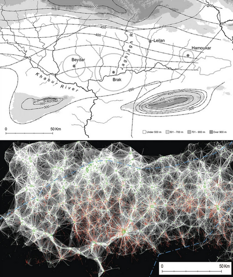
The initial image is a map with general elevation lines put in and over a representation of a drainage basin
After that things go a bit .......
The initial image is a map with general elevation lines put in and over a representation of a drainage basin
After that things go a bit .......
new topics
-
University student disciplined after saying veganism is wrong and gender fluidity is stupid
Education and Media: 29 minutes ago -
Geddy Lee in Conversation with Alex Lifeson - My Effin’ Life
People: 1 hours ago -
God lived as a Devil Dog.
Short Stories: 1 hours ago -
Happy St George's day you bigots!
Breaking Alternative News: 3 hours ago -
TLDR post about ATS and why I love it and hope we all stay together somewhere
General Chit Chat: 4 hours ago -
Hate makes for strange bedfellows
US Political Madness: 6 hours ago -
Who guards the guards
US Political Madness: 9 hours ago -
Has Tesla manipulated data logs to cover up auto pilot crash?
Automotive Discussion: 10 hours ago
top topics
-
Hate makes for strange bedfellows
US Political Madness: 6 hours ago, 14 flags -
whistleblower Captain Bill Uhouse on the Kingman UFO recovery
Aliens and UFOs: 15 hours ago, 11 flags -
Who guards the guards
US Political Madness: 9 hours ago, 10 flags -
TLDR post about ATS and why I love it and hope we all stay together somewhere
General Chit Chat: 4 hours ago, 4 flags -
Happy St George's day you bigots!
Breaking Alternative News: 3 hours ago, 3 flags -
Has Tesla manipulated data logs to cover up auto pilot crash?
Automotive Discussion: 10 hours ago, 2 flags -
God lived as a Devil Dog.
Short Stories: 1 hours ago, 2 flags -
Geddy Lee in Conversation with Alex Lifeson - My Effin’ Life
People: 1 hours ago, 2 flags -
University student disciplined after saying veganism is wrong and gender fluidity is stupid
Education and Media: 29 minutes ago, 2 flags
active topics
-
Candidate TRUMP Now Has Crazy Judge JUAN MERCHAN After Him - The Stormy Daniels Hush-Money Case.
Political Conspiracies • 730 • : Lazy88 -
The Superstition of Full Moons Filling Hospitals Turns Out To Be True!
Medical Issues & Conspiracies • 19 • : FloridaManMatty -
Iranian Regime Escalates Hiijab Mandate Through Sexual Violence and Beatings of Women
Mainstream News • 166 • : purplemer -
They Killed Dr. Who for Good
Rant • 67 • : grey580 -
Happy St George's day you bigots!
Breaking Alternative News • 31 • : BedevereTheWise -
Remember These Attacks When President Trump 2.0 Retribution-Justice Commences.
2024 Elections • 44 • : Daughter2v2 -
Thousands Of Young Ukrainian Men Trying To Flee The Country To Avoid Conscription And The War
Other Current Events • 117 • : FlyersFan -
Tucker Carlson UFOs are piloted by spiritual entities with bases under the ocean and the ground
Aliens and UFOs • 41 • : FlyersFan -
University student disciplined after saying veganism is wrong and gender fluidity is stupid
Education and Media • 1 • : watchitburn -
"We're All Hamas" Heard at Columbia University Protests
Social Issues and Civil Unrest • 247 • : FlyersFan
7