It looks like you're using an Ad Blocker.
Please white-list or disable AboveTopSecret.com in your ad-blocking tool.
Thank you.
Some features of ATS will be disabled while you continue to use an ad-blocker.

phantom chem trail or what?
page: 3share:
Originally posted by ProudBird
reply to post by Human_Alien
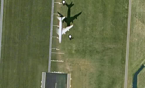
Ummmm......it is an obvious Boeing 767, I'm going to further say it is a -300 (as opposed to a -200)
Go ahead, and LOOK here:
www.boeing.com...
Look at the overhead view diagram.....then, compare (and remember to allow for the Google Earth camera distortion).
Even a broken clock is correct twice a day so you're bound to have your moment.
But once...just once I would be floored if I actually read the words "I don't know" from you! Or Phage. Or Chad.
But perhaps when you three don't comment ......it's an unspoken "I don't know"...?
And because you wholeheartedly tell us chemtrails (aerosol spraying) is a figment of our imaginations, how could you say anything OTHER than this is a regular plane?
But you might be right.
I don't have much energy on this thread. I'm saving it for something more controversial (no reflection on you OP. I S&F this anyway)
Well after looking further into the site the OP has mentioned B.Hulda & Co. I see the problem...
and ...
www.officialbhuldahcompany.com...
Just to help you out that bill was not even written by Mr.Kucinich and never passed the committee stage. It has been discussed too many times here on ATS. It was also changed 3 different times and met the same demise as the first time it was introduced.
So as far as that website and their info, well it is all in the lies that it has as evidence.
Sorry, not a good source for the chemtrail argument.
IN THE HOUSE OF REPRESENTATIVES October 2, 2001 Mr. KUCINICH introduced the following bill; which was referred to the Committee on Science, and in addition to the Committees on Armed Services, and International Relations, for a period to be subsequently determined by the Speaker, in each case for consideration of such provisions as fall within the jurisdiction of the committee concerned
and ...
SEC. 7. DEFINITIONS. In this Act:
(1) The term `space' means all space extending upward from an altitude greater than 60 kilometers above the surface of the earth and any celestial body in such space.
(2)(A) The terms `weapon' and `weapons system' mean a device capable of any of the following: (i) Damaging or destroying an object (whether in outer space, in the atmosphere, or on earth) by-- (I) firing one or more projectiles to collide with that object; (II) detonating one or more explosive devices in close proximity to that object; (III) directing a source of energy (including molecular or atomic energy, subatomic particle beams, electromagnetic radiation, plasma, or extremely low frequency (ELF) or ultra low frequency (ULF) energy radiation) against that object; or (IV) any other unacknowledged or as yet undeveloped means. (ii) Inflicting death or injury on, or damaging or destroying, a person (or the biological life, bodily health, mental health, or physical and economic well-being of a person)-- (I) through the use of any of the means described in clause (i) or subparagraph
(B); (II) through the use of land-based, sea-based, or space-based systems using radiation, electromagnetic, psychotronic, sonic, laser, or other energies directed at individual persons or targeted populations for the purpose of information war, mood management, or mind control of such persons or populations; or (III) by expelling chemical or biological agents in the vicinity of a person. (B) Such terms include exotic weapons systems such as-- (i) electronic, psychotronic, or information weapons; (ii) chemtrails; (iii) high altitude ultra low frequency weapons systems; (iv) plasma, electromagnetic, sonic, or ultrasonic weapons; (v) laser weapons systems; (vi) strategic, theater, tactical, or extraterrestrial weapons; and (vii) chemical, biological, environmental, climate, or tectonic weapons.
(C) The term `exotic weapons systems' includes weapons designed to damage space or natural ecosystems (such as the ionosphere and upper atmosphere) or climate, weather, and tectonic systems with the purpose of inducing damage or destruction upon a target population or region on earth or in space. www.carnicom.com...
www.officialbhuldahcompany.com...
Just to help you out that bill was not even written by Mr.Kucinich and never passed the committee stage. It has been discussed too many times here on ATS. It was also changed 3 different times and met the same demise as the first time it was introduced.
So as far as that website and their info, well it is all in the lies that it has as evidence.
Sorry, not a good source for the chemtrail argument.
reply to post by mark1167
It could have left anywhere near the West Coast.....Las Vegas, Los Angeles, even San Diego.
And, maybe Phoenix.
No way to tell, though. Although, if I make the effort, I can find which Jet Airway it was on.
Here, a link. Everyone can help.
Enroute H-4
Look at the St. Johns VOR.
Lat/Long coordinates are:
N 35°, 25.44
W 109°, 08.61
Close to the thread OP's picture location.
Take it from THERE!!! Look at the Jet Airways associated with all of the VORs in that location.
Later, we can find similar flights, even today....but, we need to know WHEN Google Earth took that photo!!
edit on Sun 18 March 2012 by
ProudBird because: (no reason given)
reply to post by chardonnay
I think you just figured out the answer to the air quality problem they equate to so called chemtrails.
Good Job...
This is in my backyard and I want to see tomorrow but personally,I believe the mining is more to blame for the contamination levels in the air, water, and soil.
I think you just figured out the answer to the air quality problem they equate to so called chemtrails.
Good Job...
reply to post by Human_Alien
Yeah, it WAS a random capture of a normal airliner going about its normal business, and is included in that particular frame on Google Earth.
This is a no-brainer.
GE has many OTHER random photographic captures, just like that.
My favorites, though, are the "street view" pictures.....especially, go to Honolulu (ever been there?) You can street view on the main touristy street, Kalakaua Avenue. In Waikiki. I think a lot of people told Google to "blur" their faces....some are still intact, though.
Put in the Hyatt Regency Waikiki.....into Google Maps. Go to "street view" as you zoom in.
Random captures, in time.
That is all.
reply to post by ProudBird
See how easy it is to be nice to me? Don't you feel the love? I do
I realize Google captures real-time people and things. I do live among society as much as you think I just crawled out from under a rock some times.
So I'm giving you....no argument. That's my way of saying "You may be right on this one"
(I wonder how long this ATS-love is gonna last though........ )
reply to post by Human_Alien
I have been to Honolulu, many times......because, I flew trips there.
The hotels we stayed at were in that area....the airline put us up in various hotels, over the years.....the primary one, that I stayed at he most, was one of the "SurfRiders".....here is the location:
Moana Surfrider
I LOVE Hawai'i!!! always have!!!
Yeah, it is "touristy"....but it is also very, very beautiful....when you know where to go, to find the beauty!!
Go, treat yourself to a visit!!!
(and, yes....Honolulu is just a big city).....go to the other islands.....I suggest Kuai'i, especially....VERY nice!!
No one should visit Hawai'i and not visit more then Honolulu....because to do so is to limit the experience......
reply to post by tsurfer2000h
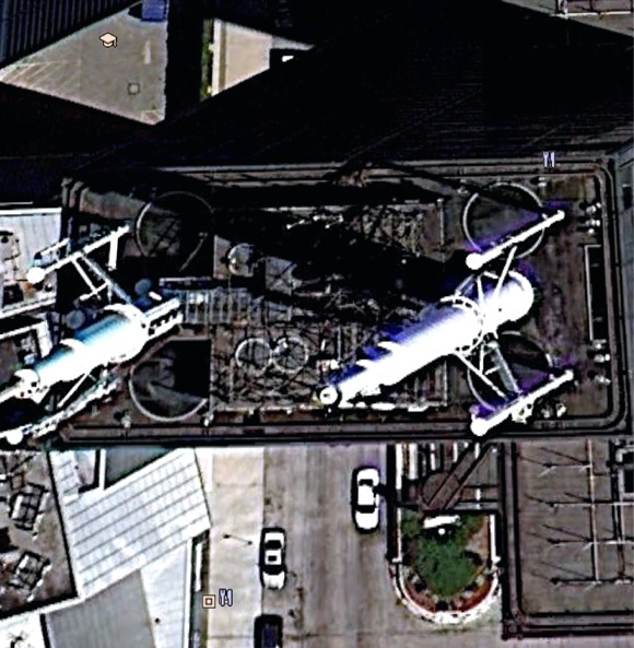
dEAR mR surfer (sorry cant type) I am well aware of the natural components of soil. I think I posted this in the wrong forum. I really am not a chemtrail advocate but do not disbelieve it either. The photo is simply not being explained well enough for my simple little brain. I traced it back to its point of origin which led me to believe it was underground.I was asked to look around the area as to what was being built over there.and I came across this peculiar picture.
dEAR mR surfer (sorry cant type) I am well aware of the natural components of soil. I think I posted this in the wrong forum. I really am not a chemtrail advocate but do not disbelieve it either. The photo is simply not being explained well enough for my simple little brain. I traced it back to its point of origin which led me to believe it was underground.I was asked to look around the area as to what was being built over there.and I came across this peculiar picture.
reply to post by ProudBird
AND, I have been to the other islands.....Maui, the Big Island, Hilo and Kona.....Etc.....
AND, I have been to the other islands.....Maui, the Big Island, Hilo and Kona.....Etc.....
reply to post by chardonnay
Are you talking about the so called chemtrail or what? Just a little confused by this post...
. I traced it back to its point of origin which led me to believe it was underground.
Are you talking about the so called chemtrail or what? Just a little confused by this post...
Originally posted by chardonnay
The photo is simply not being explained well enough for my simple little brain. I traced it back to its point of origin which led me to believe it was underground.
I thought the explanation posted by Drunkenparrot ( ) explained it quite adequately. The image artifact certainly has nothing to do with chemicals. You can see similar artifacts in other images of planes, even the ones not producing contrails.
Originally posted by Drunkenparrot
Here is an reasonable explanation from the Google Earth groups forum...
The dual color is the result of a double exposure.
The satellite that takes many of Google Earth Satellite based (high resolution) images is QuickBird it employs linear array CCDs. One set takes panchromatic images (grey scale) and the second set takes multi spectral images (MSI). The MSI imager is mounted in different physical location on the satellite so its images are acquired later in time.
These images are time re-aligned on the ground on the assumption that there are no moving objects in the field of view. As a consequence any moving object will have a colored image that appears ahead of the moving object and at lower resolutions. These images are double exposures.
If you look on highways closely where you know vehicles are traveling at 60 plus mph you will observe the same red and blue shadows. Hope this helps.
FLying plane near Luxembourg
Here are some other examples. This seems to occur more often on planes cruising, than ones at slower speeds by airports, which fits in with the explanation above.
Aircraft in flight
747 over Georgia
I think it's important that you don't treat google earth imagery as perfect photographs, as the amount of processing to stitch it all together is considerable. For example, I don't think anyone would actually try and claim this plane is flying with one wing
edit on 18/3/12 by Curious and Concerned because: doesn't quite work when in brackets
reply to post by chardonnay
It was explained by me (an educated guess) and by Drunkenparrot (the actual facts) as a compositing error,no phantoms,definitely no chemtrails and nothing that started underground.
The link below explains parallax error,the reason for the two images of the plane......
en.wikipedia.org...
It was explained by me (an educated guess) and by Drunkenparrot (the actual facts) as a compositing error,no phantoms,definitely no chemtrails and nothing that started underground.
The link below explains parallax error,the reason for the two images of the plane......
en.wikipedia.org...
edit on 19-3-2012 by Imagewerx because: (no reason given)
Originally posted by Imagewerx
reply to post by chardonnay
It was explained by me (an educated guess) and by Drunkenparrot (the actual facts) as a compositing error,no phantoms,definitely no chemtrails and nothing that started underground.
The link below explains parallax error,the reason for the two images of the plane......
en.wikipedia.org...
edit on 19-3-2012 by Imagewerx because: (no reason given)
It's not just parallax that causes the two images. Parallax is due to the camera moving, which is automatically corrected for when stitching the images, but assumes that everything is at ground level, so it gets things wrong when they are not. Here the plane is very high, so you get quite significant parallax errors between the two photos, but the plane has also moved a lot as well.
You can see lesser parallax errors in the ghosting at the top of very tall buildings. Here's the top of Sears Tower (Willis Tower) in Chicago. Note there's blue ghosting on the antenna, but there's no ghosting on the cars parked on the street below.
The parallax ghosting will be roughly north-south (as that's how the satellite flies). The motion ghosting will be in the direction of flight of the plane.
edit on 19-3-2012 by Uncinus because: (no reason given)
Originally posted by Curious and Concerned
I think it's important that you don't treat google earth imagery as perfect photographs, as the amount of processing to stitch it all together is considerable. For example, I don't think anyone would actually try and claim this plane is flying with one wing
Clear evidence of hologram aircraft!!
edit on 19-3-2012 by Aloysius the Gaul because: (no reason given)
reply to post by ProudBird
You know I thought LOL meant Lots of Love when I first read it So Love You Too! I found another one lat 35 deg 02 01 06N 109 46 20 09 W .This one heads in the opposite direction and the plane parts seem to be misplaced. I appreciate everyones input but because I am familiar with the area and the amount of air traffic this is decidedly peculiart T he technical explanations help but there is somrthing missing.When I came upon the other one Il be interested in hearing your views upon the second double exposure as you have labeled it
You know I thought LOL meant Lots of Love when I first read it So Love You Too! I found another one lat 35 deg 02 01 06N 109 46 20 09 W .This one heads in the opposite direction and the plane parts seem to be misplaced. I appreciate everyones input but because I am familiar with the area and the amount of air traffic this is decidedly peculiart T he technical explanations help but there is somrthing missing.When I came upon the other one Il be interested in hearing your views upon the second double exposure as you have labeled it
reply to post by tsurfer2000h
Yes,Not the big fat white one to the south but north of it are the air planes with one brown and one blue chemtrail or exhaustThe anomalies in the shadows on the ground and on the planes dont compute.When you think of our technology it seems juvenile in the photo. But you guys know a lot more about this stiff than I do.
Yes,Not the big fat white one to the south but north of it are the air planes with one brown and one blue chemtrail or exhaustThe anomalies in the shadows on the ground and on the planes dont compute.When you think of our technology it seems juvenile in the photo. But you guys know a lot more about this stiff than I do.
Originally posted by chardonnay
Il be interested in hearing your views upon the second double exposure as you have labeled it
Nail.......hit.A double exposure and nothing more sinister as has already been explained quite a few times.
As shown above in the photo by Uncinus,a composite photo where two adjoining images don't quite match up.

edit on 20-3-2012 by Imagewerx because: (no reason given)
edit on 20-3-2012 by Imagewerx because: (no reason given)
reply to post by Imagewerx
no, no, no - that's clearly at least 3 hologram aircraft chemtrailing to reduce excessive population in the Nevada and Arizona deserts - them ol' time prospecting types have bin gettin' a mite outta hand lately....
no, no, no - that's clearly at least 3 hologram aircraft chemtrailing to reduce excessive population in the Nevada and Arizona deserts - them ol' time prospecting types have bin gettin' a mite outta hand lately....
Originally posted by chardonnay
reply to post by tsurfer2000h
Yes,Not the big fat white one to the south but north of it are the air planes with one brown and one blue chemtrail or exhaustThe anomalies in the shadows on the ground and on the planes dont compute.When you think of our technology it seems juvenile in the photo.
Actually when I think about technology I think it is freakin' amazing hat we can do this in the first place, completely automatically - and get it so close that it takes weird little glitches like this to stop it looking perfectly!
But then I'm not one of those people who thinks that whatever we have now was actually secretly invented by the military 20-30 years ago and kept hidden from us until we were ready to hear about it
new topics
-
Supreme Court Oral Arguments 4.25.2024 - Are PRESIDENTS IMMUNE From Later Being Prosecuted.
Above Politics: 59 minutes ago -
Krystalnacht on today's most elite Universities?
Social Issues and Civil Unrest: 1 hours ago -
Chris Christie Wishes Death Upon Trump and Ramaswamy
Politicians & People: 1 hours ago -
University of Texas Instantly Shuts Down Anti Israel Protests
Education and Media: 3 hours ago -
Any one suspicious of fever promotions events, major investor Goldman Sachs card only.
The Gray Area: 5 hours ago -
God's Righteousness is Greater than Our Wrath
Religion, Faith, And Theology: 10 hours ago
top topics
-
VP's Secret Service agent brawls with other agents at Andrews
Mainstream News: 14 hours ago, 11 flags -
Nearly 70% Of Americans Want Talks To End War In Ukraine
Political Issues: 15 hours ago, 6 flags -
Sunak spinning the sickness figures
Other Current Events: 15 hours ago, 5 flags -
Electrical tricks for saving money
Education and Media: 13 hours ago, 4 flags -
Late Night with the Devil - a really good unusual modern horror film.
Movies: 17 hours ago, 3 flags -
Krystalnacht on today's most elite Universities?
Social Issues and Civil Unrest: 1 hours ago, 3 flags -
Supreme Court Oral Arguments 4.25.2024 - Are PRESIDENTS IMMUNE From Later Being Prosecuted.
Above Politics: 59 minutes ago, 3 flags -
Any one suspicious of fever promotions events, major investor Goldman Sachs card only.
The Gray Area: 5 hours ago, 2 flags -
University of Texas Instantly Shuts Down Anti Israel Protests
Education and Media: 3 hours ago, 2 flags -
Chris Christie Wishes Death Upon Trump and Ramaswamy
Politicians & People: 1 hours ago, 1 flags
active topics
-
University of Texas Instantly Shuts Down Anti Israel Protests
Education and Media • 75 • : CriticalStinker -
Nearly 70% Of Americans Want Talks To End War In Ukraine
Political Issues • 72 • : andy06shake -
Chris Christie Wishes Death Upon Trump and Ramaswamy
Politicians & People • 6 • : mysterioustranger -
"We're All Hamas" Heard at Columbia University Protests
Social Issues and Civil Unrest • 282 • : 5thHead -
British TV Presenter Refuses To Use Guest's Preferred Pronouns
Education and Media • 152 • : PorkChop96 -
Candidate TRUMP Now Has Crazy Judge JUAN MERCHAN After Him - The Stormy Daniels Hush-Money Case.
Political Conspiracies • 745 • : network dude -
President BIDEN Vows to Make Americans Pay More Federal Taxes in 2025 - Political Suicide.
2024 Elections • 141 • : Euronymous2625 -
-@TH3WH17ERABB17- -Q- ---TIME TO SHOW THE WORLD--- -Part- --44--
Dissecting Disinformation • 664 • : 777Vader -
Hate makes for strange bedfellows
US Political Madness • 46 • : network dude -
The Reality of the Laser
Military Projects • 48 • : 5thHead