It looks like you're using an Ad Blocker.
Please white-list or disable AboveTopSecret.com in your ad-blocking tool.
Thank you.
Some features of ATS will be disabled while you continue to use an ad-blocker.

A Serious Discussion On The Cascadia Subduction Zone and Latest Studies
page: 10share:
Hey Olivine!!
What do you think of the two 6'ers.....first in Peru, and now the most recent in Panama and now Mexico??
Are they going to move up into the area that this thread covers??
What do you think of the two 6'ers.....first in Peru, and now the most recent in Panama and now Mexico??
Are they going to move up into the area that this thread covers??
reply to post by radpetey
That's the multi-million dollar question, eh?
Heck if I know!
I feel like I'm always holding my breath, waiting for a large quake to smack the North American west coast; and I'm not even there. (although, I am making preparations to move back)
This anxious feeling probably stems from the knowledge of what can happen, and that some places, like the southern San Andreas, are thought* to be overdue.
*Although, geologic time-scales are so large, who knows for certain?
When Cascadia ruptures, it will probably be with no warning, no foreshocks.
If you're asking for a guess for where the next significant quake happens on the US west coast, I'll go with either near shore Eureka, CA (mag 6.5 - 7.0) or in the Lake Tahoe/Reno, NV area .
Just my wild arse guesses.
Originally posted by radpetey
Are they going to move up into the area that this thread covers??
That's the multi-million dollar question, eh?
Heck if I know!
I feel like I'm always holding my breath, waiting for a large quake to smack the North American west coast; and I'm not even there. (although, I am making preparations to move back)
This anxious feeling probably stems from the knowledge of what can happen, and that some places, like the southern San Andreas, are thought* to be overdue.
*Although, geologic time-scales are so large, who knows for certain?
When Cascadia ruptures, it will probably be with no warning, no foreshocks.
If you're asking for a guess for where the next significant quake happens on the US west coast, I'll go with either near shore Eureka, CA (mag 6.5 - 7.0) or in the Lake Tahoe/Reno, NV area .
Just my wild arse guesses.
There were 5 small quakes in less than an hours time last night in northern CA: Magnitudes 3.5, 2.5, 3.1, 2.4 & 2.8. The
focal mechanism of the M 3.5 shows a strike-slip
faulting, probably right-lateral, with a WNW strike. These were all located 27-29 kms deep. Maybe from the Pacific Plate trying to push to the
NW?
source
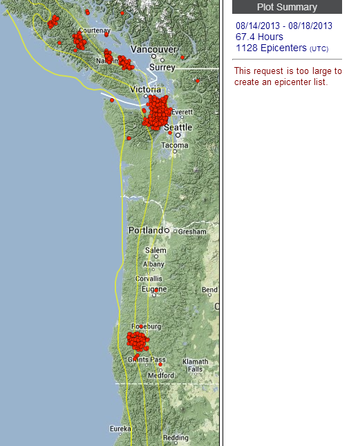
The tremor that had a run for 2 weeks or so in northern California died out. After 2 days of quiet, a new burst of activity started in southern Oregon, northern Washington, and Vancouver Island, BC. This image covers the past 5 days:
source
source
The tremor that had a run for 2 weeks or so in northern California died out. After 2 days of quiet, a new burst of activity started in southern Oregon, northern Washington, and Vancouver Island, BC. This image covers the past 5 days:
source
edit on 8/19/2013 by Olivine because: (no reason given)
I was just looking at the GPS in northern California (again, I know... it's the area I'm passionate about )
Back in July I posted about the anomalous movement on the Trinidad, CA station. It has since change direction and is heading back toward it's long term trend lines.
But just north of there, station P316 Requa, CA has taken a strong jaunt to the SE. The last time it behaved like this, as you can see on the graph, was in October 2011--but more strongly at the present.
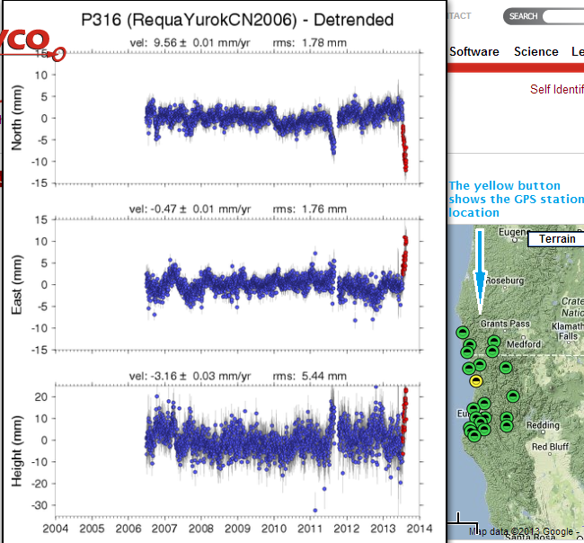
source PBO
The largest event I can find in that area from October through the end of the year in 2011, is this Mag 5.3 on the Blanco Fracture Zone. I'm not sure if there is a correlation between the GPS and quakes--but I'm watching...
If you click the 'Nearby GPS plots' link in red, on the PBO source page given above, you can see that all of the nearby stations have been pushed "up"; some more than others.
I don't know if this is deformation from the subduction zone or mountain building from the Pacific plate trying to jam past the Gorda plate.
In other news, John Vidale of PNSN has written a new blog post concerning the recent swarm of EQ's just NW of Mount Saint Helens.
And the tremor (ETS) seems to have taken a break for the past 4 days. tremor map
Back in July I posted about the anomalous movement on the Trinidad, CA station. It has since change direction and is heading back toward it's long term trend lines.
But just north of there, station P316 Requa, CA has taken a strong jaunt to the SE. The last time it behaved like this, as you can see on the graph, was in October 2011--but more strongly at the present.
source PBO
The largest event I can find in that area from October through the end of the year in 2011, is this Mag 5.3 on the Blanco Fracture Zone. I'm not sure if there is a correlation between the GPS and quakes--but I'm watching...
If you click the 'Nearby GPS plots' link in red, on the PBO source page given above, you can see that all of the nearby stations have been pushed "up"; some more than others.
I don't know if this is deformation from the subduction zone or mountain building from the Pacific plate trying to jam past the Gorda plate.
In other news, John Vidale of PNSN has written a new blog post concerning the recent swarm of EQ's just NW of Mount Saint Helens.
And the tremor (ETS) seems to have taken a break for the past 4 days. tremor map
reply to post by Olivine
Very interesting, Olivine. Is the Trinidad area "breathing"?
Thought this was Cascadia related: there was a 6.0 today off of British Columbia:
www.cbc.ca...
I read on Reuters it was in the area that had an 8.1 in 1949. Hopefully, a long over due aftershock.
Very interesting, Olivine. Is the Trinidad area "breathing"?
Thought this was Cascadia related: there was a 6.0 today off of British Columbia:
www.cbc.ca...
I read on Reuters it was in the area that had an 8.1 in 1949. Hopefully, a long over due aftershock.
These 6's on the north end of Cascadia have me a little nervous!!
2nd.
2nd.
reply to post by radpetey
Nothing like replying to my own post
This most recent 6.5 on the Alaskan islands has me really worried about the folks on the west coast of the U.S.....given the 6's that have happened today.
Olivine and I were going back and forth a couple weeks ago about the possible migration of big quakes starting in S.America, moving up to central America and then possibly striking along Cascadia at some point in the next few weeks.
This is, of course,purely speculation....however the the current situation warrants some close watching, and heads up readiness on the part of the peeps who pay attention to these kinds of things, and can give proper warning to friends and family
reply to post by radpetey
Hey Radpetey, things have gotten a bit restless the past few days, eh?
The quake sequence up near Bella Bella sure got my attention. Most of the them look to be located in the Juan de Fuca, except this mag 5.9; it's on the NA side of the CSZ. The focal mechanism shows a strike-slip, but the "double-couple" fit is only 47%--meaning that may not be a completely accurate interpretation. The depth given also makes it possible that this one quake in the sequence may have been on the subduction interface. Ah, but who knows?
And I see Costa Rica had another good sized shaker an hour or so ago, but still, all is quiet along the US Pacific coast....sooner or later something will give. Especially with all the moving the rest of the Pacific plate is doing (ie Alaska).
The real-time tremor over the past 2 days under Cascadia doesn't show concentration in any one spot; just a small amount of tremor spread throughout.
reply to post by Olivine
Hello Olivine. Thank you for the breakdown in the movement occurring in the B.C. earthquakes/aftershocks.
Have a question: Is it normal in the area of the earthquake for there to be a main shock, a series of aftershocks for less than 24 hours and then...nothing? Maybe it's because I only check USGS, but I didn't see any earthquakes today in that area. Did I miss something??
The PNSN breakdown is strange...haven't seen the broad smattering of tremors from one end to the other before.
Cascadia area sure is getting interesting.
reply to post by r4winds
I think it looks like the aftershocks just stop on USGS because they generally only report international quakes down to mag 4.5, sometimes as low as 4.0.
I've had the Bella Bella station open in GEE, and have seen many smaller aftershocks. I wouldn't worry.
Here is a link to the list of recent earthquakes from the Canadians.
It has been 11 months since the end of the last episode of tremor and associated slow-slip in the Puget Sound/Vancouver Island region. Since
discovery of this seismic phenomena, the episodes have an average recurrence interval of about 14 months.
This image from the PNSN's Wech-o-Meter shows the tremor detected over the past 2 days.
It could be a false start, and die out over the coming days, or the ETS could be starting early this time around.
Researchers believe that the likelihood of a major thrust quake on the CSZ is raised slightly (maybe as much as 10%) during a tremor episode. More info can be found here and a list of research publications here.
reply to post by Olivine
Thanks for the info Olivine! Just noticed this yesterday. Will be watching to see if develops into a real tremor event or not, but so far I'd say yes.
Curious as to what the scientist will make of the events happening over shorter periods of time. I can't help but get the impression of a countdown.
Thanks for the info Olivine! Just noticed this yesterday. Will be watching to see if develops into a real tremor event or not, but so far I'd say yes.
Curious as to what the scientist will make of the events happening over shorter periods of time. I can't help but get the impression of a countdown.
reply to post by westcoast
I'd love to be able to hear the chit-chat in the office concerning the timing of these events, too.
They are taking notice of the current activity, with the posting of a 2013 ETS event page, but it is still too early to tell if this is the real deal, or a false start.
Here is the map of the past 7 days.
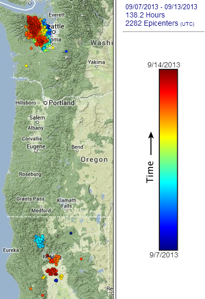
source page (set output to color vs. time, 7th - 13th Sept)
I'd love to be able to hear the chit-chat in the office concerning the timing of these events, too.
They are taking notice of the current activity, with the posting of a 2013 ETS event page, but it is still too early to tell if this is the real deal, or a false start.
Sep. 12, 2013: While there was a short burst of tremor in south-central Puget Sound on Sep 4, 2013, there was a clear and sustained period of tremor on Sep 7 and every day since then. Starting down dip (mostly west of Hood Canal) it moved first south a bit and then on Sep 11 seems to have jumped back slightly north and up-dip. This is a characteristic type of start to these ETS events. Since there have been false starts to these in the past we typically want to see ten days of tremor in a row before it is pretty much assured to be a real ETS thus we will wait for another several days before officially declaring a start.
Here is the map of the past 7 days.
source page (set output to color vs. time, 7th - 13th Sept)
Here is the latest entry from the PNSN concerning the current ETS:
Here is the tremor map showing the "jump" they reference.
source(set range 13th-14th, color vs. time)
Lastly, if you take a look at the Real-time tremor page, you can see that the detected tremor continues under southern Vancouver Island since the map above was updated at 18:50 PDT, yesterday.
Notice that an area of tremor has also begun under southern Oregon, near Grants Pass.
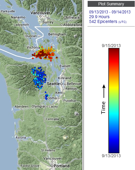
Sep. 14, 2013:
Tremor continues and is definitely moving north. In fact between 13 and 14 Sep. it jumped from the northern Olympic Peninsula almost to southern Vancouver Island and seems to be significantly more down-dip (eastward) than the track of previous ETS events in this area. The speed with which it is moving seems quite unusual.
Here is the tremor map showing the "jump" they reference.
source(set range 13th-14th, color vs. time)
Lastly, if you take a look at the Real-time tremor page, you can see that the detected tremor continues under southern Vancouver Island since the map above was updated at 18:50 PDT, yesterday.
Notice that an area of tremor has also begun under southern Oregon, near Grants Pass.
edit on 9/15/2013 by Olivine because: I inserted the map
image, but forgot the word map in the text
reply to post by Olivine
So .. what does all this mean Olivine? Just "unusual" or ???
Do you mind dumbing it down for the dummies? lol
So .. what does all this mean Olivine? Just "unusual" or ???
Do you mind dumbing it down for the dummies? lol
reply to post by MamaJ
I think why they refer the speed of travel as unusual is because normally, tremor moves along-strike about 10 km/day. Here is what John Vidale and Heidi Houston have to say about it in their 2012 paper titled Slow Slip: A New Kind of Earthquake
The tremor jumped almost 40 kms in one day along-strike*, between the 13th and 14th--4x times faster than expected, which is unusual.
(* along-strike, in Cascadia, means in a North-to-South or South-to-North direction--along the length of the subduction zone. Up-dip means toward the trench, or West, and down-dip would be Eastward.)
The .PDF linked above is a good reference to help understand tremor and slow-slip.
I hope this helps MamaJ.
ETA:
I just wanted to add, what it could indicate concerning a large megathrust quake, nobody knows.
I think why they refer the speed of travel as unusual is because normally, tremor moves along-strike about 10 km/day. Here is what John Vidale and Heidi Houston have to say about it in their 2012 paper titled Slow Slip: A New Kind of Earthquake
An intriguing feature is the variety of speeds and directions in which tremor migrates over the course of a slow-slip episode. Major episodes, such as the one shown in figure 4, migrate along the plate boundary at about 10 km/day. The progress is fitful hour by hour, but fairly steady day by day.
The tremor jumped almost 40 kms in one day along-strike*, between the 13th and 14th--4x times faster than expected, which is unusual.
(* along-strike, in Cascadia, means in a North-to-South or South-to-North direction--along the length of the subduction zone. Up-dip means toward the trench, or West, and down-dip would be Eastward.)
The .PDF linked above is a good reference to help understand tremor and slow-slip.
I hope this helps MamaJ.
ETA:
I just wanted to add, what it could indicate concerning a large megathrust quake, nobody knows.
edit on 9/15/2013 by Olivine because: add a thought
reply to post by Olivine
Thanks so much for keeping up on this Olivine! I just started back to work after some time, and am working on my second book, so have been pretty absent from everything else.
I did catch mention of this on the PNSN FB site...and IMO, this has crossed into the event zone. WAY too many dots on that map to say it isn't a real ETS.
The speed at which this last group moved is...well, like you said; odd. The fact that this event is also so early, makes it even more...notable.
SO, please keep in mind I am not a scientist, and I think at time they think I over-react because of my lack of knowledge, but for me it is all about the bigger picture. They believe that ETS is about 'loading'. But no one knows for sure what it is, to be frank. They say there is about a 10% greater chance of the big one happening during an ETS becuase of this loading....but again, no one really knows what it is, so this is all theory until is is proven or disproven. We know what is involve in the prove/disprove scenario, so I am okay with just sticking to theories for now.
I have made this comparisson before and it still rings true for me, so here it is. I see it like a 2x4. If you take it and bend it to just before its breaking point, it starts to creak and moan. You will then see cracks form and spread along its length, radiating from the stress point. Just before it explodes, I would imagine that if you could record it and then slow it WAYYYYYYY down, you would hear a lot of moaning sounds from the wood as the stress and energy building up battles with the law of physics.
so this isn't really an accurate comparison, becuase we are talkign about a subduction zone vs a fault, but I think the same idea could apply. I view the deep tremor as a type of 'moaning' being released in the form of energy, along the area of the subduction zone. As this energy occurs in closer, and closer duration and especially as it speeds up, it raises concern for me that we are getting closer to the breaking point. We are talking in geological time though....so even if the clock is ticking down, it could be a matter of days, weeks or hundreds of years.
Fascinating stuff.
ETA: Okay, I know all the scientists would totally slam me, but it hasn't stopped me in the past: I can't help but wonder at this early, fast ETS in relation to the current swarm happening at Yellowstone. There. I said it.
edit on 15-9-2013 by westcoast because: (no reason
given)
reply to post by westcoast
Wow, you're busy, Westcoast. Congrats on the 1st book! I see the link in your sig--I'll have to find time to give it read.
This recent tremor is indeed looking like the real thing. And as you say, it's early return is an eyebrow raiser. The map for yesterday (below) shows additional areas of tremor joining in.
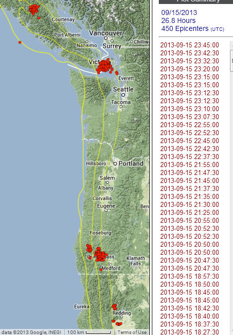
source page
Geologic processes are so hard to interpret on human time-scales, but I agree, it feels like an acceleration in significant events, all pointing toward movement on the big fault. When, though?
I've always like your 2x4 analogy. It works. The timing of the Yellowstone activity is curious. I have no idea what mechanism could connect the two, but our modern understanding of tectonics is so young, who really knows for sure?
Don't let "the scientists" stop you from hypothesizing.
Wow, you're busy, Westcoast. Congrats on the 1st book! I see the link in your sig--I'll have to find time to give it read.
This recent tremor is indeed looking like the real thing. And as you say, it's early return is an eyebrow raiser. The map for yesterday (below) shows additional areas of tremor joining in.
source page
Geologic processes are so hard to interpret on human time-scales, but I agree, it feels like an acceleration in significant events, all pointing toward movement on the big fault. When, though?
I've always like your 2x4 analogy. It works. The timing of the Yellowstone activity is curious. I have no idea what mechanism could connect the two, but our modern understanding of tectonics is so young, who really knows for sure?
Don't let "the scientists" stop you from hypothesizing.
Hmm, the current tremor episode is continuing to confound the experts. From the latest 2013
Tremor Blog update
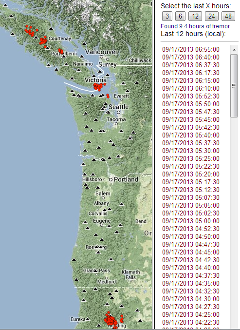
Since the above blog entry was posted, the real-time tremor map (set to show past 12 hours), shows a line of weak tremor from SE of Victoria headed NW toward Port Hardy. But the activity in northern California remains steady.
Maybe it was just a false-start and we will have to wait until October/Novermber for the real deal.
I'll tell you, it's hard not to make another mental checkmark in the anomalous activity column, but then my more rational self asks, "anomalous compared to what"? Our seismic history of the area is just too short and incomplete to try and draw conclusions.
Sep. 16, 2013:
Oh dear, it may be dying out. There was only about 5 hours of weak tremor today located just south of yesterday's tremor. It may be trying to fill in the gap left when it jumped from the Olympic Peninsula to the southern coast of Vancouver Island late on Sep 13. This gap is well resolved by two diferent subnetworks of stations and is pretty unique in the record looking back to other tremor episodes. This gap is unusual enough to get the attemtion of Dr. Herb "ETS" Dragert of PGC who seems more than a little interested in such an observation. Herb looked into possible GPS signals and reports:
What I can add at this stage is that as of yesterday, I have not been able to resolve any displacements for GPS stations in the tremor region which is unusual for 9 days of tremor. This would be consistent with slip (if any) on the plate interface being very small at this stage (i.e. less than ~0.5 cm) or slip occurring deeper which would result in reduced surface displacements.
Since the above blog entry was posted, the real-time tremor map (set to show past 12 hours), shows a line of weak tremor from SE of Victoria headed NW toward Port Hardy. But the activity in northern California remains steady.
Maybe it was just a false-start and we will have to wait until October/Novermber for the real deal.
I'll tell you, it's hard not to make another mental checkmark in the anomalous activity column, but then my more rational self asks, "anomalous compared to what"? Our seismic history of the area is just too short and incomplete to try and draw conclusions.
edit on 9/17/2013 by Olivine
because: forgot the image
Yes...so the tremor didn't die out...it has expanded into several distinct clusters of activity.
This is the tremor map from yesterday, 18 September 2013:
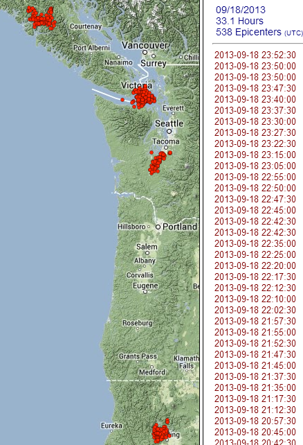
And this is the tremor map since the activity began 7 September, through yesterday the 18th.
Blue is oldest, dark red the most recent.
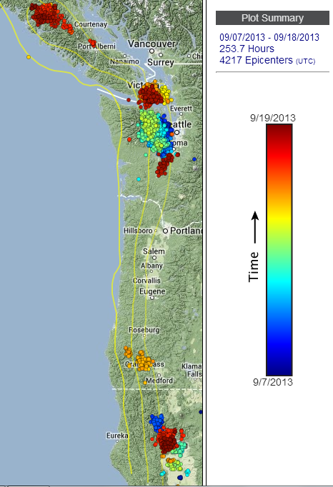
PNSN tremor map
You can see that the tremor detected in the north, near the Puget Sound has bifurcated.. It has done that before. But the persistant tremor under north-central Vancouver Island and northern California, at the same time, make this episode a bit more interesting.
I'm curious to read any new comments on the blog following the current activity, found here.
This is the tremor map from yesterday, 18 September 2013:
And this is the tremor map since the activity began 7 September, through yesterday the 18th.
Blue is oldest, dark red the most recent.
PNSN tremor map
You can see that the tremor detected in the north, near the Puget Sound has bifurcated.. It has done that before. But the persistant tremor under north-central Vancouver Island and northern California, at the same time, make this episode a bit more interesting.
I'm curious to read any new comments on the blog following the current activity, found here.