It looks like you're using an Ad Blocker.
Please white-list or disable AboveTopSecret.com in your ad-blocking tool.
Thank you.
Some features of ATS will be disabled while you continue to use an ad-blocker.

Coming Face to Face With An Escalating Volcano from 5000km Away
page: 1share:
Ok, so maybe this wasn't such a good idea. Somehow after all this I find myself tipped off from the inside and involved a little more than causally
with the watching of the Iliamna Volcano, just south of Redoubt and north of Augustine in Alaska.
Its advisory status was just upgraded to Yellow, as seismic activity has risen above background levels:
Iliamna Activity - Color Code YELLOW : Alert Level ADVISORY
www.avo.alaska.edu...
I have known about this for a couple of days, and well, suffice it to say that there may be some late overnight hours where my eyes may be the only ones on it- with a set of instructions, some spiffy software, close consultations, and a cell phone number- just in case I see anything bad.
lol. ummm...ok.... So help... If this darn thing blows on my watch I am going to freak. All they gave me was the name of the thing and one station to watch at first... ILW. But you could say I went quite a bit further than that, and now find myself terrified to look away- because I am unofficially part of the "keep and eye on it" few that are, well...keeping an eye on it. No one is expecting it to blow, cause it has done this before. But darn...I think I might be rather watching a Netflix movie.
Just goes to show...Be careful what you wish for...
You can see the recent seismic activity here:
earthquake.usgs.gov...
So anyone wanna have some fun, go and bring some more things that contribute to this...more maps, history, and all that good stuff...and we can all watch it together.
Even if it does blow, it probably won't do all that much damage...The area is sparsely populated. But then again, it's been a while since a bigger eruption. It's just kind of cool to be watching it in realtime this close.
Its advisory status was just upgraded to Yellow, as seismic activity has risen above background levels:
Iliamna Activity - Color Code YELLOW : Alert Level ADVISORY
2012-03-10 11:44:19 - Status Report
Seismic activity at Iliamna Volcano remains above background. This sustained seismic activity does not mean that an eruption is imminent or certain. A similar seismic swarm was detected in 1996/1997 that was likely related to an intrusion of magma at depth did not culminate in an eruption.
www.avo.alaska.edu...
I have known about this for a couple of days, and well, suffice it to say that there may be some late overnight hours where my eyes may be the only ones on it- with a set of instructions, some spiffy software, close consultations, and a cell phone number- just in case I see anything bad.
lol. ummm...ok.... So help... If this darn thing blows on my watch I am going to freak. All they gave me was the name of the thing and one station to watch at first... ILW. But you could say I went quite a bit further than that, and now find myself terrified to look away- because I am unofficially part of the "keep and eye on it" few that are, well...keeping an eye on it. No one is expecting it to blow, cause it has done this before. But darn...I think I might be rather watching a Netflix movie.
Just goes to show...Be careful what you wish for...
You can see the recent seismic activity here:
earthquake.usgs.gov...
So anyone wanna have some fun, go and bring some more things that contribute to this...more maps, history, and all that good stuff...and we can all watch it together.
Even if it does blow, it probably won't do all that much damage...The area is sparsely populated. But then again, it's been a while since a bigger eruption. It's just kind of cool to be watching it in realtime this close.
edit on Sun Mar 11th 2012 by TrueAmerican because: (no reason
given)
Sounds like a really nice 'relaxing' way to spend your weekend , and its true, be careful what you wish for... you just might get it.
reply to post by TrueAmerican
Well it is alaska and it is along the ring of fire. So, what else is to be expected?
Well it is alaska and it is along the ring of fire. So, what else is to be expected?
reply to post by Bakatono
Nothing is expected at this point...
And I don't want to anyone think that they are relying on my interpretive skills, because they aren't. The extent of my contribution is that I showed them that I could identify bigger seismic events quickly, among telemetry error, and tougher, among ice quakes. So I am useable on the front lines to be able to call and say "yeah, we're getting 3.5's and 4.5's now, they are coming in fast...and I might have seen tremor..." Anything less and their phone doesn't ring... but their pagers probably will. Tremor may not get alerted though, and that is always a problem...it could happen at any time in the context of all the other seismic activity, and yet still not be of high enough amplitude to key the auto alert threshold.
It's just there are not enough hours in the day to for a relatively few people to analyze all the data coming from everywhere, to a depth that is scientific. I am just basically a little additional front line defense against quick escalation. They need be able to notify the FAA as soon as possible because of the "flight in ash cloud" problem. And if big pieces of glaciers start rolling down hills and hitting rivers... The bottom line is they do need volunteer help. And so I found a little spot where I am helping and gaining more experience at the same time.
edit on Sun Mar 11th
2012 by TrueAmerican because: (no reason given)
Excellent that you are able to put your graph analysis talents to good use on something like this.
Which seismographs are you looking at?
edit: this one? ILW_EHZ_AV
I went through the page you linked to, yes the 9th and 10th did have quite a few micro quakes didn't they.
and from there to the Google Earth/Smithsonian text on the volcano
I wonder what they mean by;
Nearest stratovolcano to me is only 188km away, Ruapehu, never forget back in 1995/96 (VE3 eruptions) we could see the plume from our house on a clear day.
exciting stuff
Which seismographs are you looking at?
edit: this one? ILW_EHZ_AV
I went through the page you linked to, yes the 9th and 10th did have quite a few micro quakes didn't they.
and from there to the Google Earth/Smithsonian text on the volcano
I wonder what they mean by;
elevated seismicity accompanying dike emplacement beneath the volcano was recorded in 1996.
Nearest stratovolcano to me is only 188km away, Ruapehu, never forget back in 1995/96 (VE3 eruptions) we could see the plume from our house on a clear day.
exciting stuff
edit on 11-3-2012 by muzzy because: add link to seismo
I am also on watch for this one, but I am only about 130 miles away. Not sure I am overly worried though. This guy rumbles every so often and
looking at the history of it, there doesn't seem to be a history of massive eruptions. That also could be bad I guess. I mean eventually it will go
huh? Small rumblings only though, so no real fear. I flew over both Iliamna and Rdoubt a couple of times this summer. Both were steaming slightly,
but still had tons of snow on them. We will see. Keep watching.
Also, on my drive into Anc everyday, I can see Redoubt on most days, but on a REALLY clear day, I can see the very top of Iliamna. If I can, next time I drive in I will try to snap a pic of it for you.
Also, on my drive into Anc everyday, I can see Redoubt on most days, but on a REALLY clear day, I can see the very top of Iliamna. If I can, next time I drive in I will try to snap a pic of it for you.
edit on 11-3-2012 by Girdwood because: (no reason given)
Originally posted by Girdwood
Also, on my drive into Anc everyday, I can see Redoubt on most days, but on a REALLY clear day, I can see the very top of Iliamna. If I can, next time I drive in I will try to snap a pic of it for you.
Actually, I am very interested in that. In fact, I need a pic pretty bad right now of its condition in the last day. Yeah, I see the one of March 9th.
I am actually in this a bit deeper than I wanted to be, but with some serious observation hours in already on this thing, there have been some very curious things happening. And I also know there is not consensus that the "ice quakes" are indeed ice quakes. Not everyone agrees with that, so I have been told, and I may be one of them in this case. I believe I have just identified a slight movement in the "ice quake" source, by timed arrival differences.
No one is disputing the declared network seismic events. But these ice quake signatures are proving to be an interesting item, for sure. Especially when all of a sudden they increase in power to the point that there is seismic propagation out to 187km confirmed.
If I only had the benefit of close observation from the previous high activity period- but I don't.
Muz, thanks for the vote of confidence, I appreciate it. Read around the AVO website on it some more and perhaps check out the BUD interface for their network to see what you have to work with.
Any GEE watchers that want to get involved, please setup perimeter detection against teleseisms. Or you are going to be screaming "TREMOR" at every single one of them. And they really don't like that. NO, they don't. Trust me. That much I do know. Waste any of their time on tele's, and you just make them irritated. Cause they don't have the time to deal with it...
I doubt the pic would do you any good at all. It would just show up as a tiny peak on the horizon 130 miles away and give no detail. I have freinds
on The Kenai Peninsula that might have a better view. I will talk to them. Also, I have a good freind that is a flight attendant for PenAir. Let me
talk to her and see if she is headed to Dillingham or King Salmon anytime soon. Those flights often go almost directly ove Iliamna and/or Redoubt.
Maybe she can snap a pic.
Originally posted by TrueAmerican
Read around the AVO website on it some more and perhaps check out the BUD interface for their network to see what you have to work with.
Had a look at what IRIS has to offer, quite a few stations around Iliamna but only ILW (which has nothing for day 70?) and ILS (perhaps the better one?)seem to be useable.
what the heck is this about I wonder?, from IVE right on the edge of a huge glacier
Tried to match the USGS list with the ILW_EHZ_AV graph and only matched about half.
Must be a lot of < Mag 1's on that
Good luck
www.avo.alaska.edu...
Is the area you are watching? There are two cams in the area. Looks extremely cold there. Alaska always seems so active with small tremors that I just never really look at it as a potential volcanic eruption except for Cleveland.
Is the area you are watching? There are two cams in the area. Looks extremely cold there. Alaska always seems so active with small tremors that I just never really look at it as a potential volcanic eruption except for Cleveland.
edit on 11-3-2012 by AuntB because: clarification
reply to post by TrueAmerican
Wow, thanks for starting this thread!
I've been wondering if there was a volcano associated with the apparent swarm near Pedro Bay since I noticed it.
I've been in & out for days & only had time for a quick look at USGS. Then when the bigger one happened, I wondered if there was another fault line. The way they line up too, in the bay or whatever it is. Made me think of the Mississippi!
Interesting stuff. Good to know you're keeping an eye on it!
Too close for comfort to Anchorage!
WOQ
From what I am seeing so far on this, the smaller events as well as most of the bigger events appear to be coming from the same general area, an area
on the southeast side of the summit:
www.avo.alaska.edu...
Not sure, but I think the March 9 pic found here...
www.avo.alaska.edu...
...might have the spot, which I cropped out and reduced a bit, if I have matched this up right by terrain:
Keep in mind the summit is to the right of this area cropped in the pic. But this area seems to have some kind of depression, as you can see. And of course a lot of snow. If below that is ice, and heat from a limited area below has started melting the ice underneath at the ice/rock interface- it might be possible that the ice and snow are sinking into the depression. With each move, it might be causing the smaller quakes. So they could be ice quakes in that sense, I suppose.
But if it is a magma source that is driving this mechanism from below, causing this, maybe it is another lateral dike being placed? Given that we seem to be getting a blip on the radar type repetitive signature that appears to be further north and possibly deep, and seeing that line of quakes across the peak, I am thinking the magma source could be coming in deep from the north, headed south, and this fluid could be pooling under our little spot there, causing the heating, and hence the smaller "ice" quakes. And maybe even some bigger ice quakes if a large part of ice and snow slid down together. Is why we need an updated pic... to see if any new fumaroles might have sprung up, implying a heat source emerging.
I have proposed this idea to my contact, and it turns out that may be one line of reasoning they are thinking on too. "Absolutely, " was the reply, more or less. The fluid might be water too, not necessarily magma. It's fun watching though and trying to figure out the mechanics and resonance of the mountain at different spots. I am just trying to keep an eye out for tremor, but some have erupted before without any signs of volcanic or harmonic tremor. So tremor detection is not a catch all, but if tremor happens, we can always heed the warning.
Iliamna is not on 24/7 watch officially. And if it went to that, I seriously doubt I would be part of things at that point. "Get out of here kid, we got this now." There would be plenty of eyes on it, and there are probably many scientists all over the world who were alerted to the status upgrade- and have been looking too. There are bigger fish to fry for them at the moment.
And oh, dear John and Steve, your mysterious chirp there looks very much like a teleseism received at or near the edge of the propagation radius. I see em all the time.
www.avo.alaska.edu...
Not sure, but I think the March 9 pic found here...
www.avo.alaska.edu...
...might have the spot, which I cropped out and reduced a bit, if I have matched this up right by terrain:
Keep in mind the summit is to the right of this area cropped in the pic. But this area seems to have some kind of depression, as you can see. And of course a lot of snow. If below that is ice, and heat from a limited area below has started melting the ice underneath at the ice/rock interface- it might be possible that the ice and snow are sinking into the depression. With each move, it might be causing the smaller quakes. So they could be ice quakes in that sense, I suppose.
But if it is a magma source that is driving this mechanism from below, causing this, maybe it is another lateral dike being placed? Given that we seem to be getting a blip on the radar type repetitive signature that appears to be further north and possibly deep, and seeing that line of quakes across the peak, I am thinking the magma source could be coming in deep from the north, headed south, and this fluid could be pooling under our little spot there, causing the heating, and hence the smaller "ice" quakes. And maybe even some bigger ice quakes if a large part of ice and snow slid down together. Is why we need an updated pic... to see if any new fumaroles might have sprung up, implying a heat source emerging.
I have proposed this idea to my contact, and it turns out that may be one line of reasoning they are thinking on too. "Absolutely, " was the reply, more or less. The fluid might be water too, not necessarily magma. It's fun watching though and trying to figure out the mechanics and resonance of the mountain at different spots. I am just trying to keep an eye out for tremor, but some have erupted before without any signs of volcanic or harmonic tremor. So tremor detection is not a catch all, but if tremor happens, we can always heed the warning.
Iliamna is not on 24/7 watch officially. And if it went to that, I seriously doubt I would be part of things at that point. "Get out of here kid, we got this now." There would be plenty of eyes on it, and there are probably many scientists all over the world who were alerted to the status upgrade- and have been looking too. There are bigger fish to fry for them at the moment.
And oh, dear John and Steve, your mysterious chirp there looks very much like a teleseism received at or near the edge of the propagation radius. I see em all the time.
edit on Mon Mar 12th 2012 by TrueAmerican because: (no reason given)
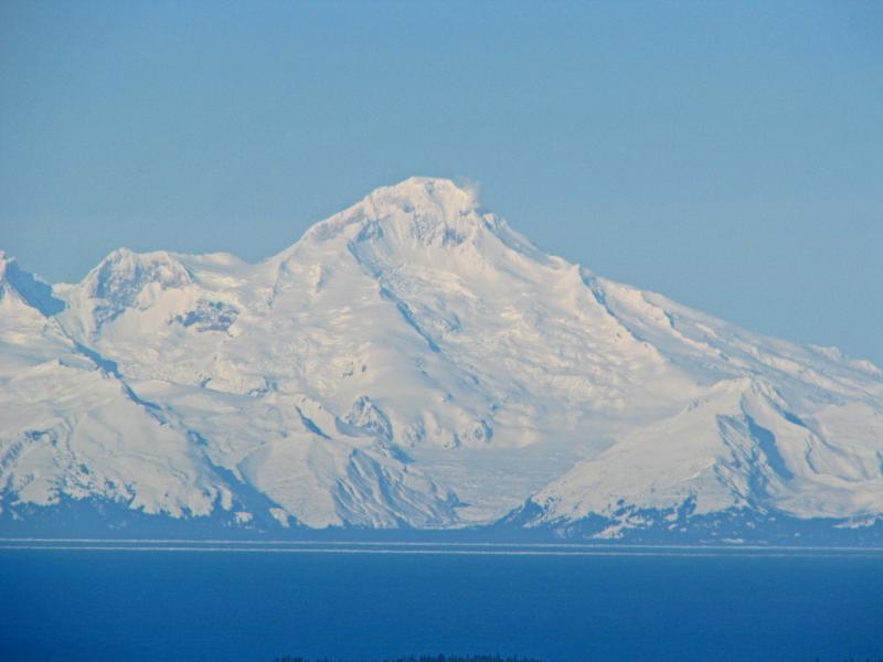
reply to post by TrueAmerican
Here you go
Source
Here you go
View of Iliamna on the morning of March 9, 2012, from Diamond Ridge on the Kenai Peninsula. Iliamna's prominent and long-lived fumaroles are visible. Photograph courtesy of Dennis Anderson, Night Trax Photography.
Date: March 09, 2012
Volcano(es): Iliamna
Photographer/Creator: Anderson, Dennis;
Source
I couldn't see clear enough today for Iliamna, but I could see Redoubt just fine. Redoubt has a huge steam plume on it's north side from the looks of
it. Pretty good size, maybe 1000+ feet. Have not yet checked AVO for the cam.
Link for Redoubt Cam
Yep, BIG plume. Looked cool in the sunrise this morning.
Link for Redoubt Cam
Yep, BIG plume. Looked cool in the sunrise this morning.
edit on 12-3-2012 by Girdwood because: Added Redoubt cam link
Well it seems some reviews of quakes are in, and now the picture changes dramatically:
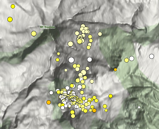
www.avo.alaska.edu...
A lot going on under that mountain. And I guess the question is, how much of it is seismic, and how much is due to ice. And just as I typed that another 2.0+ or so just hit the mountain.
www.avo.alaska.edu...
A lot going on under that mountain. And I guess the question is, how much of it is seismic, and how much is due to ice. And just as I typed that another 2.0+ or so just hit the mountain.
edit on Mon Mar 12th 2012 by TrueAmerican because: (no reason given)
reply to post by TrueAmerican
WOW!!!! Insane! What is the time frame from oldest to most recent quake? Redoubt was really steaming early but died off by afternoon. Rare to see steam from Redoubt at that level from 100+ miles away. I will keep an eye on it. If it is clear in the morning I will try to take a pic. Especially if Redoubt steams again.
My first thoghts are mixed. It is far from the higher elevations where massive snow/ice would collect. However we are experiencing an above average snow year. Not just above average, but it is record setting. I am well over 200 inches for the year at my house and the entire region is setting records, so it could be extra snow weight. Just sayin.
Thoughts?
edit on 13-3-2012 by Girdwood because: comment
Originally posted by Girdwood
Thoughts?
That's good information, my friend. Call your friends and tell them to get as many pics as possible, ALL OVER that mountain. Please? And especially, the third peak over to the left from the summit, and its down slope. Right where all the smaller quakes are occurring. Tripod. Max resolution. Max zoom. Steady clear pics.
You get those and I'll give you my email outside of here. Cause we need em. The plane is not certified yet, last I heard, and the gas emissions people have not been able to make flight yet. There is no GPS, so we can't monitor deformation. Seismicity is pretty much all we have to go on at the moment.
And yeah, I got some more thoughts. My contact just laid on me a PDF from an expert in glacial ice, done specifically at Iliamna, and all its characteristics and trimmings- including, and not limited to, seismic characteristics of avalanches, and their precursors. And after reading that, I am coming close to the conclusion that this may be much less ice, and more seismicity- although we also could be seeing a combination of underlying seismicity that could be causing some pre avalanche precursors.
So now with all that above average snow, the chances of an avalanche here appear to be quite high, at least to me. At the very least. And the seismicity below is not helping at all. Quite on the contrary- the seismicity is increasing those chances quite easily as the shaking, and possible heat from magma or heated water, plays into this. Iliamna has BIG avalanches, and they occur very often, and out of character compared to other areas. I now have the seismic signatures of those, and I can tell you that at onset an avalanche could easily fool anyone into thinking tremor has started.
But I see any signature that looks like either, here coming up, and yeah, their phone is going to ring. Obviously, with all those quakes we can see now at that third peak, this is a spot to particularly watch out for. Either that, or the mountain might be ready to open up a new fumarole vent. And let's hope that is just a fumarole vent, and not worse.
I just talked to my friend at PenAir. She won't fly that route again until Sunday, but she said she would try to snap a few pics. She flew over it
last week and she didn't notice any steaming or anything unusual, which makes sense.
Originally posted by Girdwood
I am also on watch for this one...
Could you possibly clarify that, please? To what degree are you on watch here? Are you saying you are just keeping an eye on it as a citizen, or are you watching this thing with real time spectro, and know the players involved? That matters, is why I ask the question.
Originally posted by TrueAmerican
Originally posted by Girdwood
I am also on watch for this one...
Could you possibly clarify that, please? To what degree are you on watch here? Are you saying you are just keeping an eye on it as a citizen, or are you watching this thing with real time spectro, and know the players involved? That matters, is why I ask the question.
No, just watching it because if it blows I would see it. It is only 130 miles away, so could impact me. I just want to know if it is about to blow. I work with a ton of geologists, so I bet at least one of them knows someone that is actually "watching" this. I will start asking around.
new topics
-
VP's Secret Service agent brawls with other agents at Andrews
Mainstream News: 1 hours ago -
Sunak spinning the sickness figures
Other Current Events: 1 hours ago -
Nearly 70% Of Americans Want Talks To End War In Ukraine
Political Issues: 2 hours ago -
Late Night with the Devil - a really good unusual modern horror film.
Movies: 3 hours ago -
Cats Used as Live Bait to Train Ferocious Pitbulls in Illegal NYC Dogfighting
Social Issues and Civil Unrest: 5 hours ago -
The Good News According to Jesus - Episode 1
Religion, Faith, And Theology: 7 hours ago -
HORRIBLE !! Russian Soldier Drinking Own Urine To Survive In Battle
World War Three: 9 hours ago
top topics
-
SETI chief says US has no evidence for alien technology. 'And we never have'
Aliens and UFOs: 16 hours ago, 8 flags -
Florida man's trip overseas ends in shock over $143,000 T-Mobile phone bill
Social Issues and Civil Unrest: 12 hours ago, 8 flags -
Cats Used as Live Bait to Train Ferocious Pitbulls in Illegal NYC Dogfighting
Social Issues and Civil Unrest: 5 hours ago, 7 flags -
VP's Secret Service agent brawls with other agents at Andrews
Mainstream News: 1 hours ago, 5 flags -
Former Labour minister Frank Field dies aged 81
People: 14 hours ago, 4 flags -
HORRIBLE !! Russian Soldier Drinking Own Urine To Survive In Battle
World War Three: 9 hours ago, 3 flags -
Bobiverse
Fantasy & Science Fiction: 12 hours ago, 3 flags -
Nearly 70% Of Americans Want Talks To End War In Ukraine
Political Issues: 2 hours ago, 3 flags -
Sunak spinning the sickness figures
Other Current Events: 1 hours ago, 3 flags -
Late Night with the Devil - a really good unusual modern horror film.
Movies: 3 hours ago, 2 flags
active topics
-
Late Night with the Devil - a really good unusual modern horror film.
Movies • 4 • : DBCowboy -
Hate makes for strange bedfellows
US Political Madness • 41 • : Solvedit -
Nearly 70% Of Americans Want Talks To End War In Ukraine
Political Issues • 11 • : DBCowboy -
SETI chief says US has no evidence for alien technology. 'And we never have'
Aliens and UFOs • 40 • : Irishhaf -
President BIDEN Vows to Make Americans Pay More Federal Taxes in 2025 - Political Suicide.
2024 Elections • 124 • : Justoneman -
Ditching physical money
History • 20 • : GENERAL EYES -
Sunak spinning the sickness figures
Other Current Events • 3 • : NoCorruptionAllowed -
VP's Secret Service agent brawls with other agents at Andrews
Mainstream News • 13 • : DAVID64 -
The Reality of the Laser
Military Projects • 42 • : Zaphod58 -
HORRIBLE !! Russian Soldier Drinking Own Urine To Survive In Battle
World War Three • 27 • : RickyD