It looks like you're using an Ad Blocker.
Please white-list or disable AboveTopSecret.com in your ad-blocking tool.
Thank you.
Some features of ATS will be disabled while you continue to use an ad-blocker.

Geoengineering - caught in the act?
page: 11share:
reply to post by thorfourwinds
Those cloud types are perfectly normal contrails.
Notice that, unlike the OP's examples, those didn't "spread out"...they remained compactly arranged. This is merely due to varying conditions that existed, and the difference from where and when those photos were, to the location and time of the OP's.
It is very simple science....IF you bother to actually research the facts, and not the pseudo-claptrap nonsense that surrounds this topic.
And, making fun of member's usernames is pretty pathetic, and borderline T & C actionable.
Move along, folks. That's right. Nothing to see here.
These trails are normal I tell you. Completely normal. Just like Monsanto's food -- Normal!
These trails are normal I tell you. Completely normal. Just like Monsanto's food -- Normal!
Originally posted by tsurfer2000h
Or you should possibly call it I am only guessing Geoengineering is happening and not actually caught in the act.
You do understand English ...no?
So you understand the meaning of the ? mark.
And thats hilarious...man you guys are desperate!
Originally posted by ProudBird
reply to post by thorfourwinds
Those cloud types are perfectly normal contrails.
Notice that, unlike the OP's examples, those didn't "spread out"...
Prove that!
I say you cant, because unlike the OP set of photos, those dont have followups.
But I would wager a bet that if they did, they would also contain sulfate particulates.
By the way, I saw a post the other day in a Jet Pilot forum, seems they are hiring
SRM pilots...for SRM flights.
What are you going to do when it becomes public knowledge?!
edit on 11-3-2012 by burntheships because: (no reason given)
reply to post by pianopraze
????
Now, you are dissembling:
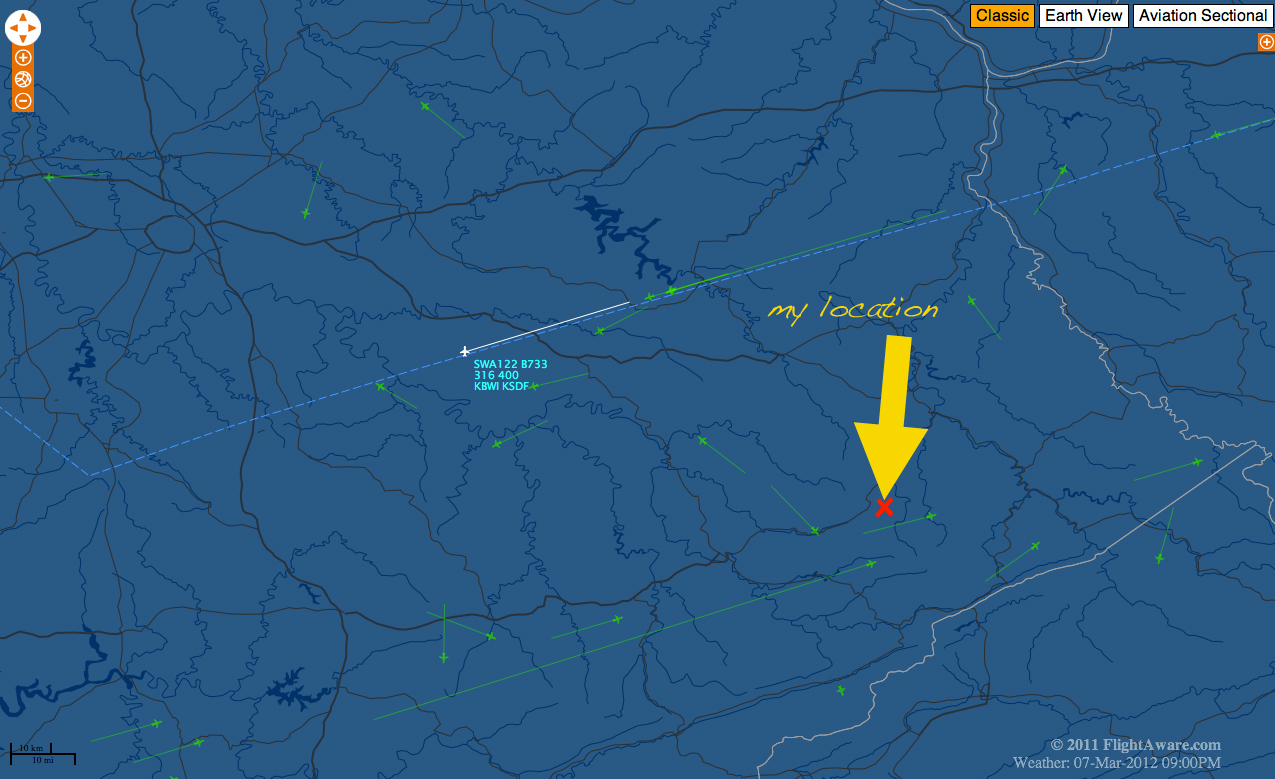
I can see the airplanes in the Flight Aware screenshot! Why are you claiming otherwise? I hate accuse you of intentionally stringing this thread along, just for your own reasons, but.......
Maybe you do not understand how to interpret the Flight Aware information? The little airplane icons tend to be "pointed" in the approximate direction of travel...think of them as tiny models. You can see the faint green 'trails' behind them, too....to indicate their ground track paths.
I posted the Aviation Chart link, too. I still didn't see your reply to that information.....did I miss it? If so, then link to that earlier post of yours.
See, so far what we have is:
Photos of contrails, taken one evening at a time when there are still plenty of commercial airline flights going about their business.
An incorrectly-timed screenshot and link to weather balloon (radiosonde) data that was off by many hours, from the time of the photos.
And, a misunderstanding that is perpetuated by one, and only one, screen shot from Flight Aware, that cannot properly represent the dynamic
activity of the many flights, nor can it adequately be compared to the photos from the OP....
Does that about summarize it?
If not sinking in yet.....
Those were perfectly normal contrails formed by average airplanes just flying along, doing what they do. At a time when conditions were suitable for such contrails to form, and in this instance, to also tend to persist and linger.
Furthermore, the conditions that existed led to not only those contrails persisting, but their mere presence caused a further reaction in the super-saturated airmass region that contributed to more formation of additional cirrus clouds.
This is exactly how it occurs in Nature, when cirrus clouds form. The presence of the contrails, and the presence of the airplanes, merely acted as a trigger to spur it along. It was going to happen anyway, regardless whether the airplanes existed, or not. The cirrus clouds can move in, also....at normal Human timescales, this is not obvious. It is, though, when viewed in time-lapse(**)
It is extremely sad to see the perpetuation of claims that are completely unsubstantiated, based solely on such abject misinformation and, yes.....ignorance....of the actual science involved here. The science of meteorology.
(**) Video of cirrus evolution, in time-lapse:
(Go to 2:00. especially)
It is science, people!!
Here, this is about as basic as it can get....even a second-grader will understand:
????
Now, you are dissembling:
Doesn't line up with the direction. Sorry. There were a lot going North/South and north west/south east, southeast/northwest...
I can see the airplanes in the Flight Aware screenshot! Why are you claiming otherwise? I hate accuse you of intentionally stringing this thread along, just for your own reasons, but.......
Maybe you do not understand how to interpret the Flight Aware information? The little airplane icons tend to be "pointed" in the approximate direction of travel...think of them as tiny models. You can see the faint green 'trails' behind them, too....to indicate their ground track paths.
I posted the Aviation Chart link, too. I still didn't see your reply to that information.....did I miss it? If so, then link to that earlier post of yours.
See, so far what we have is:
Does that about summarize it?
If not sinking in yet.....
Those were perfectly normal contrails formed by average airplanes just flying along, doing what they do. At a time when conditions were suitable for such contrails to form, and in this instance, to also tend to persist and linger.
Furthermore, the conditions that existed led to not only those contrails persisting, but their mere presence caused a further reaction in the super-saturated airmass region that contributed to more formation of additional cirrus clouds.
This is exactly how it occurs in Nature, when cirrus clouds form. The presence of the contrails, and the presence of the airplanes, merely acted as a trigger to spur it along. It was going to happen anyway, regardless whether the airplanes existed, or not. The cirrus clouds can move in, also....at normal Human timescales, this is not obvious. It is, though, when viewed in time-lapse(**)
It is extremely sad to see the perpetuation of claims that are completely unsubstantiated, based solely on such abject misinformation and, yes.....ignorance....of the actual science involved here. The science of meteorology.
(**) Video of cirrus evolution, in time-lapse:
(Go to 2:00. especially)
It is science, people!!
Here, this is about as basic as it can get....even a second-grader will understand:
edit on Sun 11 March 2012 by ProudBird because: (no reason given)
reply to post by burntheships
My guess is that he and they will start arguing about why it's necessary and safe, so still nothing to worry about. Remember, everything's normal.
What are you going to do when it becomes public knowledge?!
My guess is that he and they will start arguing about why it's necessary and safe, so still nothing to worry about. Remember, everything's normal.
reply to post by pianopraze
I Live in Sherbrooke, Quebec and I have seen strange clouds. Usually clouds are puffy with rounded shapes. But these one were spiky and long. Some were blending like sunrays in the sky when another cloud passed in front of the sun after the strange clouds. Dont have pictures of it.
I Live in Sherbrooke, Quebec and I have seen strange clouds. Usually clouds are puffy with rounded shapes. But these one were spiky and long. Some were blending like sunrays in the sky when another cloud passed in front of the sun after the strange clouds. Dont have pictures of it.
reply to post by ProudBird
There are a lot more planes flying over than are on the radar. I could see more planes in the sky than are on the radar that I could see when I went in.
Period.
I have gladly engaged with you in this thread as you were being strait up. Are you getting desperate now?
Sorry, I don't engage that type of tactic. Should have known it would turn from real inquiry to all out name calling at some point given the history of this subject, but I don't want to be part of that. Seems the serious part of this thread is over and the trolling is beginning.
Sorry if my data offends your belief patters. Denial does not negate data.
I will have no part of this decent. I have seen the propagandists do it time and again. Turn a good thread into a troll fest so no one wants to go in that is not a troll. That seems a common tactic of some people on here to keep people from looking at a topic.
reply to post by burntheships
They better tell the 190 signatories who agreed to ban geoengineering 16 months ago then...
www.abovetopsecret.com...
What are you going to do when it becomes public knowledge?!
They better tell the 190 signatories who agreed to ban geoengineering 16 months ago then...
www.abovetopsecret.com...
reply to post by Afterthought
Well when that happens, and it will because your guess is right, lets get screen shots!
Little does Proud Bird know....
Or little he lets on to know....
All this talk of Meteorologists "owning" all of the knowledge...
Well they certainly do know some things...and much of what they do behind closed doors
is kept as close knowledge...however sometimes we can take a peek into the meetings....
Like this one -
American Meterological Society 2012
ams.confex.com...
92nd American Meteorological Society Annual Meeting (January 22-26, 2012): Aerosol,
Precipitation, and Cloud Properties—
E-PEACE (Eastern Pacific Emitted Aerosol-Cloud Experiment 2011).
... a technique for dispensing GCCN (milled salt particles) in marine stratocumulus clouds and then measuring the response of the cloud to the seeding was developed and tested.
The Twin Otter was equipped with an extensive suite of instrumentation for characterizing clouds and aerosols and measuring meteorology parameters and turbulence. A 95 GHz Doppler cloud radar was operated in an upward facing configuration to measure cloud and precipitation structures observed above the aircraft and served as an effective tool for detecting a broadening of the cloud droplet spectrum and drizzle production due to seeding. The salt powder consists of salt milled to 3-5 micron particles that are coated to minimize clumping. The particles were dispensed from the Twin Otter using an apparatus that uses a variable-speed auger feed to deliver salt from a reservoir into a fluidized bed of sand (to breakup any particle clusters) and then blow the particles into the airstream from a tube extending from the underside of the aircraft fuselage. ams.confex.com...
Originally posted by pianopraze
It's fairly easy... they flew over in directions that there are no flights on the radar... even phage acknowledge this.
No, I read the post by Phage that you refer to. I am puzzled by it, because I think he's incorrect:
Originally posted by Phage
OK, let's talk about that. I do not see large numbers of planes in your images. But it is difficult to explain the contrail at 8:54 (no plane visible) which appears to run from the northwest to the southeast (or vice versa, roughly). No such flightpath appears on the Flightaware shot.
I see many flights that are more generally North/South, (or southeast/northwest, Etc) in addition to the ones generally East/West
Originally posted by Chadwickus
reply to post by burntheships
What are you going to do when it becomes public knowledge?!
They better tell the 190 signatories who agreed to ban geoengineering 16 months ago then...
www.abovetopsecret.com...
That does not apply to geoengineering. Thats only applicable to the "intention".
reply to post by burntheships
Well, sure.
Also, it's not difficult to see (with your own two eyes) that the Op is demonstrating exactly how China's energy can be tampered with. Since China uses solar energy for the majority of their power, SRM can easily be used for weather warfare, too.
Piano's use of the full moon in these photos shows exactly how easily it is to lessen the impact of the sun's rays and dim the surface.
We also both understand how manufactured clouds can obstruct radar to prevent the enemy from knowing exact locations of planes and ships. Maybe they were utilizing these perfect night time atmospheric and planetary conditions to test or iron out the technology?
reply to post by pianopraze
How many? Specific number.
And, did you then watch the Flight Aware screen for the next 8 minutes (at least)? Because, those that you saw "live", with your Mark II eyeballs, would have been represented on Flight Aware in positions of about an 8-minute lag time.
You could click on those, the ones that you could view (on Flight Aware) and get their identity.....you could have seen the ones that would correlate with the ones you personally saw. How can I better explain this???
On Flight Aware, you could look at airplanes within about an 80-mile radius of your location, that are on headings and courses that would cause them to eventually fly over or near your location. THOSE would be (because of the time lag) the ones you actually saw @2105 or thereabouts.
This would be so much easier to describe, and to show, in a one-on-one situation.
To inject a phrase...."Evidence of absence is not absence of evidence".
NONE of this "controversy" would be occurring IF Flight Aware did not have that time delay!! Try to understand that simple fact.
I could see more planes in the sky than are on the radar that I could see when I went in.
How many? Specific number.
And, did you then watch the Flight Aware screen for the next 8 minutes (at least)? Because, those that you saw "live", with your Mark II eyeballs, would have been represented on Flight Aware in positions of about an 8-minute lag time.
You could click on those, the ones that you could view (on Flight Aware) and get their identity.....you could have seen the ones that would correlate with the ones you personally saw. How can I better explain this???
On Flight Aware, you could look at airplanes within about an 80-mile radius of your location, that are on headings and courses that would cause them to eventually fly over or near your location. THOSE would be (because of the time lag) the ones you actually saw @2105 or thereabouts.
This would be so much easier to describe, and to show, in a one-on-one situation.
To inject a phrase...."Evidence of absence is not absence of evidence".
NONE of this "controversy" would be occurring IF Flight Aware did not have that time delay!! Try to understand that simple fact.
Originally posted by ProudBird
Originally posted by pianopraze
It's fairly easy... they flew over in directions that there are no flights on the radar... even phage acknowledge this.
No, I read the post by Phage that you refer to. I am puzzled by it, because I think he's incorrect:
Originally posted by Phage
OK, let's talk about that. I do not see large numbers of planes in your images. But it is difficult to explain the contrail at 8:54 (no plane visible) which appears to run from the northwest to the southeast (or vice versa, roughly). No such flightpath appears on the Flightaware shot.
I see many flights that are more generally North/South, (or southeast/northwest, Etc) in addition to the ones generally East/West
The planes going N/S to the west of me I would have never saw and there is no way i photographed them to my EAST!!! There is a huge mountain to my back (the west) and I never photographed or saw those. I did see the ones making the spreading persistent contrails.
This is my last attempt with you. Your mindset has totally overrides everything. I have enjoyed our conversation but at this point I'm done and a little saddened.
reply to post by Afterthought
How is any airplane going to fly unmolested through Chinese airspace at 30,000 feet??
And, a little bit of high-level cirrus cloud as a "weapon"? That's quite the stretch. If anything, China has their own aviation and airline industry, and therefore make their own contrails already......
....but, besides that. Why is it that NO ONE simply sits down and takes the time to actually measure the total surface area of the Earth that is "covered" at any given moment by clouds??
Does anyone understand my point, there?
reply to post by burntheships
Um.
Yes it does...
That does not apply to geoengineering
Um.
Yes it does...
The 193 signatories to the convention agreed to outlaw such geoengineering projects "until there is an adequate scientific basis on which to justify such activities and appropriate consideration of the associated risks for the environment and biodiversity and associated social, economic and cultural impacts".
reply to post by Afterthought
Yes, its interesting that it seemed localized, and was at night.
They can modify cloulds by aerosols, much evidence has been posted to that affect...and
they certainly can use it for weather warfare.
They also do localized testing, and here is another glimpse into an experiment that took
place. E-PEACE
While that one took place in Montery, who knows what they are doing in other places?
Yes, its interesting that it seemed localized, and was at night.
They can modify cloulds by aerosols, much evidence has been posted to that affect...and
they certainly can use it for weather warfare.
They also do localized testing, and here is another glimpse into an experiment that took
place. E-PEACE
The Eastern-Pacific Emitted Aerosol Cloud Experiment (E-PEACE) uses satellite and in situ ship- and airplane-based measurements of anthropogenic aerosol in stratocumulus off the coast of Monterey, Calif., to shed light on cloud-property modification by aerosol. One novel aspect of the experiment is the controlled release of aerosol particles. These order 100 nm-diameter particles are produced on board a ship at a rate of 10^15 s^-1 and greater along pre-selected ship tracks to raise aerosol concentration above marine background levels over areas of hundreds of km^2 in area. Production of the aerosol patterns is timed to permit study by instrumented aircraft and the morning and afternoon Earth Observing System (EOS) satellite constellations. We describe the particle release patterns employed in the E-PEACE 2011 campaign and the cloud structures into which the particles were released, and we present results from the study of these tracks and other ship tracks using EOS satellite cloud and aerosol observations. ams.confex.com...
While that one took place in Montery, who knows what they are doing in other places?
reply to post by Afterthought
Normal, like the star you saw in the photos, right?
Not having a go, just pointing out different perceptions people have and how until I pointed out the obviousness of it being lens flare, you thought it was something celestial.
Same could be said for contrails.
Just a thought...
Normal, like the star you saw in the photos, right?
Not having a go, just pointing out different perceptions people have and how until I pointed out the obviousness of it being lens flare, you thought it was something celestial.
Same could be said for contrails.
Just a thought...
reply to post by pianopraze
I have tried to patiently explain to you, best as can be done in this medium. It is limiting, but I can see the errors in your assumptions.....I simply cannot, without being able to speak and directly interact, and show you, where the mistaken assumptions lie.
I've been able to use Flight Aware to identify airplanes, but I admit it isn't a simple task...the damn time lag makes it very difficult. It also takes a bit of aviation knowledge (I know, I know!) to make the difference in understanding.
But, setting all of that "he said/she said" aside. There is a very, very simple and basic problem with the OP and the claim:
The very inexact and non-scientific observational techniques are not enough to validate such a claim.
In this modern era, there would (by now) be ample photographic evidence of the actual equipment, the devices, attached to any airplane so equipped that was dedicated to "spraying" at and above 30,000 feet altitude.
There are too many eyes, and cameras, nowadays for any such activity to have gone undetected. Also, there are just too many people who would have to be involved. And, before the claim of "Military!" is shouted, there are plenty of ex-military "grunts" (those who would have to be involved in the "dirty work") to have not come forward,by now.
The ability to be totally anonymous exists....and yet, not one peep.
Why is that, do you suppose?
Your mindset has totally overrides everything.
I have tried to patiently explain to you, best as can be done in this medium. It is limiting, but I can see the errors in your assumptions.....I simply cannot, without being able to speak and directly interact, and show you, where the mistaken assumptions lie.
I've been able to use Flight Aware to identify airplanes, but I admit it isn't a simple task...the damn time lag makes it very difficult. It also takes a bit of aviation knowledge (I know, I know!) to make the difference in understanding.
But, setting all of that "he said/she said" aside. There is a very, very simple and basic problem with the OP and the claim:
"Geoengineering - caught in the act?"
The very inexact and non-scientific observational techniques are not enough to validate such a claim.
In this modern era, there would (by now) be ample photographic evidence of the actual equipment, the devices, attached to any airplane so equipped that was dedicated to "spraying" at and above 30,000 feet altitude.
There are too many eyes, and cameras, nowadays for any such activity to have gone undetected. Also, there are just too many people who would have to be involved. And, before the claim of "Military!" is shouted, there are plenty of ex-military "grunts" (those who would have to be involved in the "dirty work") to have not come forward,by now.
The ability to be totally anonymous exists....and yet, not one peep.
Why is that, do you suppose?
new topics
-
God lived as a Devil Dog.
Short Stories: 11 minutes ago -
Happy St George's day you bigots!
Breaking Alternative News: 1 hours ago -
TLDR post about ATS and why I love it and hope we all stay together somewhere
General Chit Chat: 2 hours ago -
Hate makes for strange bedfellows
US Political Madness: 4 hours ago -
Who guards the guards
US Political Madness: 7 hours ago -
Has Tesla manipulated data logs to cover up auto pilot crash?
Automotive Discussion: 9 hours ago
top topics
-
Hate makes for strange bedfellows
US Political Madness: 4 hours ago, 14 flags -
whistleblower Captain Bill Uhouse on the Kingman UFO recovery
Aliens and UFOs: 14 hours ago, 11 flags -
Who guards the guards
US Political Madness: 7 hours ago, 10 flags -
1980s Arcade
General Chit Chat: 16 hours ago, 7 flags -
Deadpool and Wolverine
Movies: 17 hours ago, 4 flags -
TLDR post about ATS and why I love it and hope we all stay together somewhere
General Chit Chat: 2 hours ago, 3 flags -
Has Tesla manipulated data logs to cover up auto pilot crash?
Automotive Discussion: 9 hours ago, 2 flags -
Happy St George's day you bigots!
Breaking Alternative News: 1 hours ago, 2 flags -
God lived as a Devil Dog.
Short Stories: 11 minutes ago, 1 flags
active topics
-
"We're All Hamas" Heard at Columbia University Protests
Social Issues and Civil Unrest • 241 • : FlyersFan -
Candidate TRUMP Now Has Crazy Judge JUAN MERCHAN After Him - The Stormy Daniels Hush-Money Case.
Political Conspiracies • 722 • : RazorV66 -
Happy St George's day you bigots!
Breaking Alternative News • 11 • : Oldcarpy2 -
TLDR post about ATS and why I love it and hope we all stay together somewhere
General Chit Chat • 6 • : Mantiss2021 -
God lived as a Devil Dog.
Short Stories • 0 • : BrotherKinsMan -
-@TH3WH17ERABB17- -Q- ---TIME TO SHOW THE WORLD--- -Part- --44--
Dissecting Disinformation • 615 • : daskakik -
whistleblower Captain Bill Uhouse on the Kingman UFO recovery
Aliens and UFOs • 16 • : pianopraze -
1980s Arcade
General Chit Chat • 21 • : chris_stibrany -
Hate makes for strange bedfellows
US Political Madness • 30 • : nugget1 -
Who guards the guards
US Political Madness • 3 • : theatreboy