It looks like you're using an Ad Blocker.
Please white-list or disable AboveTopSecret.com in your ad-blocking tool.
Thank you.
Some features of ATS will be disabled while you continue to use an ad-blocker.

NASA's Yuma UFO Spotted on Google Maps? (Video)
page: 13
share:
Source
I wanted to share this with all of you as it is quite the 'object'.
The fact it is so hidden and remote is quite interesting and provides quite the mystery surrounding the 'object'.
There are plenty of questions on what this could be but I thought I would bring it here to see if anyone had any extra information on it.
Good find though and will be interesting to hear peoples opinions.
Any thoughts?
Pred...
An intrepid YouTuber has unearthed a strange object on Google Maps which looks like a UFO on a landing strip in Yuma, AZ. What is it?
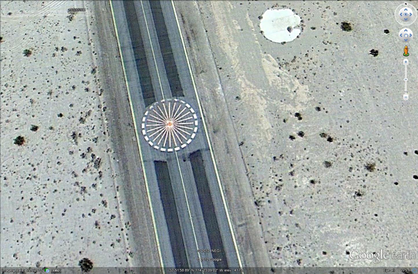
The image below shows what looks like the classic ET mothership from above as seen in the aerial view over the Yuma Proving Ground, an airstrip and government hangar facility near the city in Arizona.
Whatever it is, it doesn't resemble any known aircraft or ground markings. Is there a secret project going on? Why in such a remote location? No matter the purpose, this image is sure to spark the imagination of UFO hunters around the world.
The video has no commentary, just a walk-through of the user zeroing in on the unidentified object at coordinates 32.866436,-114.385992 in Google Maps.
I wanted to share this with all of you as it is quite the 'object'.
The fact it is so hidden and remote is quite interesting and provides quite the mystery surrounding the 'object'.
There are plenty of questions on what this could be but I thought I would bring it here to see if anyone had any extra information on it.
Good find though and will be interesting to hear peoples opinions.
Any thoughts?
Pred...
While it's not the best picture for id purposes, it looks like something printed/painted on the runway to me.
Originally posted by predator0187
I wanted to share this with all of you as it is quite the 'object'.
The fact it is so hidden and remote is quite interesting and provides quite the mystery surrounding the 'object'.
There are plenty of questions on what this could be but I thought I would bring it here to see if anyone had any extra information on it.
Good find though and will be interesting to hear peoples opinions.
Any thoughts?
Pred...
I do not support any of the claims. This "object" may not be an object but a certain part of the runway being highlighted by a design for what looks like practical purposes: it's right on the middle of the runway. It might be a sign for pilots to realize that they are at the halfway mark to continue on or to abort the flight.
According to the map it is about 80ft in diameter. It's color is pretty crisp too.
What reason would there be to spend money on painting such an image that wide in the middle of a road/runway?
What reason would there be to spend money on painting such an image that wide in the middle of a road/runway?
Originally posted by predator0187
There are plenty of questions on what this could be but I thought I would bring it here to see if anyone had any extra information on it.
Yup. How about an oblique aerial photograph. Seems to be painted on the tarmac.
www.abovetopsecret.com...
edit on 3/2/2012 by Phage because: (no reason given)
...um... Lens flare? No really, maybe something of the sort, can't this be the result of a powerful light shooting straight up?
reply to post by Phage
No. It's been there since 2003 (at least). Here's the 2011 image.

(click it)
Looks a VOR/DME transmitter. Navigation. (this one isn't that one)

No. It's been there since 2003 (at least). Here's the 2011 image.
(click it)
Looks a VOR/DME transmitter. Navigation. (this one isn't that one)
edit on 3/2/2012 by Phage because: (no reason given)
reply to post by Phage
Interesting choice of non-occult like symbolism. I'm sure that was the only option they had to go with. Definitely painted on though (or not going by the picture above), I think case closed on this being anything alien. Hard to tell what anything is from such heights.
Interesting choice of non-occult like symbolism. I'm sure that was the only option they had to go with. Definitely painted on though (or not going by the picture above), I think case closed on this being anything alien. Hard to tell what anything is from such heights.
edit on 2-3-2012 by JibbyJedi because: (no reason given)
reply to post by Phage
Why must you always have to ruin our imagination?
Why must you always have to ruin our imagination?
edit on 2-3-2012 by Manhater because: (no reason given)
reply to post by Phage
(edit) ...looked at the photo you linked in post, the overhead. Yeah, looks painted on. Or, I wonder if that is in the process of being installed, and those are the locations laid out and marked?
It does look a lot like a VOR, except for the brightness of the central portion. (But, the concrete ramp to the North, and the Taxiway Delta is abnormally "bright" looking too.....might just have to do with the satellite imaging factors).
And for someone who thought it was a marking on the Runway...it is not located on a Runway....it's on a Taxiway.
If it's a VORTAC it isn't on the Charts:
Link
But, as an AAF there could be a reason it was installed, just for their own purposes....and not civilian use.
Oh and here is the latest Airport Diagram for comparison to the Google Map image.
Whatever is there (or painted?) when the photo was taken is on Taxiway Echo ('E').
edit on Fri 2 March 2012 by ProudBird because: (no reason given)
reply to post by ProudBird
What do you know about TACAN systems? Could that be it?
www.globalair.com...
What do you know about TACAN systems? Could that be it?
www.globalair.com...
reply to post by Phage
TACAN is military only. A VORTAC is a VOR and TACAN that are co-located. Civilian VOR receivers (on VHF) automatically tune the corresponding TACAN UHF freq....but only the DME portion of the TACAN signal is used.
The military can use TACAN for both distance and azimuth, though. They are tuned on designated "channels" (as opposed to a VOR or VORTAC on VHF). The "channel" corresponds to the appropriate UHF freq for the TACAN station.
And in your link, the NYL TACAN is listed.....about 16 miles SW of the Laguna AAF. This would put it on the field at the Yuma International Airport, a joint-use Civil/Military. IATA airport code is 'YUM'. ICAO is'KNYL'.
Airport identifier - KNYL
Looking at the published Airport Diagram for KNYL, since it's for civilian use, the TACAN location is not marked.
But its Lat/Long are listed:
You can use the Lat/Long grid on the Diagram to determine where it is.
Also note that both Runway 3L/21R and 3R/21L have arresting gear, both directions.
Those are the arrows shown near the ends , pointing in both directions, either side. Labelled 'E-28'. That is a code for the military pilots denoting the type of arresting system. *
* FYI, found this....on last page (Pp. 31) of thie PDF are the codes. Published by Boeing, for civilian pilots' awareness.....
TACAN is military only. A VORTAC is a VOR and TACAN that are co-located. Civilian VOR receivers (on VHF) automatically tune the corresponding TACAN UHF freq....but only the DME portion of the TACAN signal is used.
The military can use TACAN for both distance and azimuth, though. They are tuned on designated "channels" (as opposed to a VOR or VORTAC on VHF). The "channel" corresponds to the appropriate UHF freq for the TACAN station.
And in your link, the NYL TACAN is listed.....about 16 miles SW of the Laguna AAF. This would put it on the field at the Yuma International Airport, a joint-use Civil/Military. IATA airport code is 'YUM'. ICAO is'KNYL'.
Airport identifier - KNYL
Looking at the published Airport Diagram for KNYL, since it's for civilian use, the TACAN location is not marked.
But its Lat/Long are listed:
32-38-48.490N (32.647) 114-36-48.388W (-114.613)
You can use the Lat/Long grid on the Diagram to determine where it is.
Also note that both Runway 3L/21R and 3R/21L have arresting gear, both directions.
Those are the arrows shown near the ends , pointing in both directions, either side. Labelled 'E-28'. That is a code for the military pilots denoting the type of arresting system. *
* FYI, found this....on last page (Pp. 31) of thie PDF are the codes. Published by Boeing, for civilian pilots' awareness.....
edit on Fri 2 March 2012 by ProudBird because: (no reason given)
What a surprise. The youtube posted deleted my post explaining that it is a navigational aid.
new topics
-
Las Vegas UFO Spotting Teen Traumatized by Demon Creature in Backyard
Aliens and UFOs: 2 hours ago -
2024 Pigeon Forge Rod Run - On the Strip (Video made for you)
Automotive Discussion: 3 hours ago -
Gaza Terrorists Attack US Humanitarian Pier During Construction
Middle East Issues: 4 hours ago -
The functionality of boldening and italics is clunky and no post char limit warning?
ATS Freshman's Forum: 5 hours ago -
Meadows, Giuliani Among 11 Indicted in Arizona in Latest 2020 Election Subversion Case
Mainstream News: 5 hours ago -
Massachusetts Drag Queen Leads Young Kids in Free Palestine Chant
Social Issues and Civil Unrest: 6 hours ago -
Weinstein's conviction overturned
Mainstream News: 7 hours ago -
Supreme Court Oral Arguments 4.25.2024 - Are PRESIDENTS IMMUNE From Later Being Prosecuted.
Above Politics: 8 hours ago -
Krystalnacht on today's most elite Universities?
Social Issues and Civil Unrest: 9 hours ago -
Chris Christie Wishes Death Upon Trump and Ramaswamy
Politicians & People: 9 hours ago
top topics
-
Krystalnacht on today's most elite Universities?
Social Issues and Civil Unrest: 9 hours ago, 9 flags -
Supreme Court Oral Arguments 4.25.2024 - Are PRESIDENTS IMMUNE From Later Being Prosecuted.
Above Politics: 8 hours ago, 8 flags -
Weinstein's conviction overturned
Mainstream News: 7 hours ago, 7 flags -
University of Texas Instantly Shuts Down Anti Israel Protests
Education and Media: 11 hours ago, 6 flags -
Gaza Terrorists Attack US Humanitarian Pier During Construction
Middle East Issues: 4 hours ago, 5 flags -
Meadows, Giuliani Among 11 Indicted in Arizona in Latest 2020 Election Subversion Case
Mainstream News: 5 hours ago, 5 flags -
Massachusetts Drag Queen Leads Young Kids in Free Palestine Chant
Social Issues and Civil Unrest: 6 hours ago, 4 flags -
Las Vegas UFO Spotting Teen Traumatized by Demon Creature in Backyard
Aliens and UFOs: 2 hours ago, 3 flags -
Chris Christie Wishes Death Upon Trump and Ramaswamy
Politicians & People: 9 hours ago, 2 flags -
2024 Pigeon Forge Rod Run - On the Strip (Video made for you)
Automotive Discussion: 3 hours ago, 2 flags
active topics
-
Supreme Court Oral Arguments 4.25.2024 - Are PRESIDENTS IMMUNE From Later Being Prosecuted.
Above Politics • 78 • : chr0naut -
Meadows, Giuliani Among 11 Indicted in Arizona in Latest 2020 Election Subversion Case
Mainstream News • 11 • : YourFaceAgain -
University of Texas Instantly Shuts Down Anti Israel Protests
Education and Media • 199 • : Irishhaf -
The Acronym Game .. Pt.3
General Chit Chat • 7750 • : bally001 -
-@TH3WH17ERABB17- -Q- ---TIME TO SHOW THE WORLD--- -Part- --44--
Dissecting Disinformation • 681 • : MetalThunder -
Chris Christie Wishes Death Upon Trump and Ramaswamy
Politicians & People • 20 • : chr0naut -
Las Vegas UFO Spotting Teen Traumatized by Demon Creature in Backyard
Aliens and UFOs • 7 • : rickymouse -
University student disciplined after saying veganism is wrong and gender fluidity is stupid
Education and Media • 50 • : watchitburn -
VP's Secret Service agent brawls with other agents at Andrews
Mainstream News • 55 • : CarlLaFong -
Cats Used as Live Bait to Train Ferocious Pitbulls in Illegal NYC Dogfighting
Social Issues and Civil Unrest • 23 • : Ravenwatcher
3