It looks like you're using an Ad Blocker.
Please white-list or disable AboveTopSecret.com in your ad-blocking tool.
Thank you.
Some features of ATS will be disabled while you continue to use an ad-blocker.

North Atlantic Hurricane Watch 2012
page: 1share:
2012 Atlantic Hurricane Season on Wikipedia
Outlook: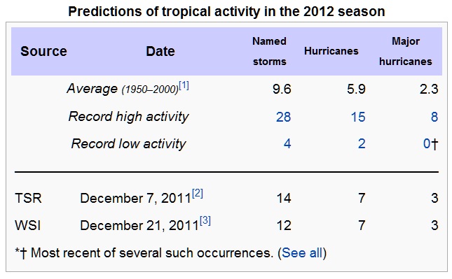
Names: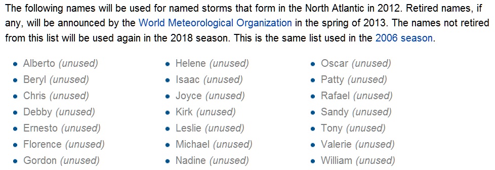
Hurricanes, Tropical Storms, Tropical Depressions, or Tropical Waves can be reported in this thread. Significant or particularly destructive storms can of course also be reported as individual threads.
Here are a few helpful links I've used in the past:
Tropical Weather & Hurricanes page @ Weather Underground
Hurricane Central @The Weather Channel
National Hurricane Center Satellite page
Hurricane supply kit
FEMAs hurricane links (yeah, I know we bash them a lot, but there is good info here)
Link to 2011 Thread
2011 Hurricane Wiki
I would also suggest one read through The Redneck's thread: 14 hours in Hell, 4 days to Home on what can happen in severe weather and how it can be dealt with.
If you've got a link, please share it. The more prepared we are, the better able we will be to help others.
If it isn't mentioned in the above linked references, make sure you have a way to charge your cell phone/lap top batteries. If you don't have a generator, buy yourself a couple of power inverters and you can use your vehicle as a generator for a bit if need be.
I've been through Alicia, Ike and every other storm in the Texas Gulf coast for the past 43 years so I know what to expect. My avatar is the memorial statue to the 1900 Galveston Hurricane, so this is nothing new.
Our advanced technology and ability to communicate with one another give us a tremendous advantage over our ancestors; let us use that to our benefit.
Been doing some reading on and off about a variety of subjects at an equally wide range of sites. I came across this study published in 2010:
African Dust Influence on Atlantic Hurricane Activity and the Peculiar Behaviour of Category 5 Hurricanes
From the abstract:
And looking at the statistics for 2011, we can see that there was not a Cat 5 storm in the North Atlantic, and only 2 Cat 4 storms.
Timeline of the 2011 Atlantic hurricane season
Will be interesting to look back at the end of this season and see if it holds true.
African Dust Influence on Atlantic Hurricane Activity and the Peculiar Behaviour of Category 5 Hurricanes
From the abstract:
We identify the formation of Category 5 hurricanes occurring mainly around the decadal minimum variation of African dust and in deep water areas of the Atlantic Ocean, where hurricane eyes have the lowest pressure. According to our results, future tropical cyclones will not evolve to Category 5 until the next decadal minimum that is, by the year 2015 +/- 2.
And looking at the statistics for 2011, we can see that there was not a Cat 5 storm in the North Atlantic, and only 2 Cat 4 storms.
Timeline of the 2011 Atlantic hurricane season
Will be interesting to look back at the end of this season and see if it holds true.
Hey,JC!
I have a new toy for you to play with.
oiswww.eumetsat.org...
All kinds of fun satellite features on there.
By the looks of it,seems to be getting a head start off of the Verdes.
You be safe down there in hurricane country,it has been rough here in the midwest with the tornadoes,so early in the season.
I just wanted to post a quick update to this thread.
For my birthday last month, I got a professional weather station from Oregon Scientific so I will be able to post real time updates during hurricane conditiions in the Upper Texas Coast, specifically in the Galveston Bay area.
Hopefully those situations are mild and nothing severe comes our way, but this is hurricane country and I've lived through many prior so I fully expect to see our share of tropical cyclones.
And we have our first low pressure area of interest in the Northern Atlantic:
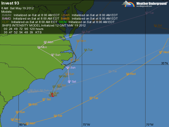
Invest 93

Atlantic Overview at the National Hurricane Center
Probably won't develop too much, but those of you on the east coast should remain aware of this system.
Invest 93
Atlantic Overview at the National Hurricane Center
Probably won't develop too much, but those of you on the east coast should remain aware of this system.
reply to post by jadedANDcynical
It wouldn't hurt to include an update, this has developed into Tropical Storm Alberto.
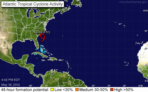
(Source: National Hurricane Center)
It's worth monitoring, but not worth inciting panic. Although this does serve as a reminder, even tropical systems can form with little warning. Landfall is not the time to be gathering emergency supplies!
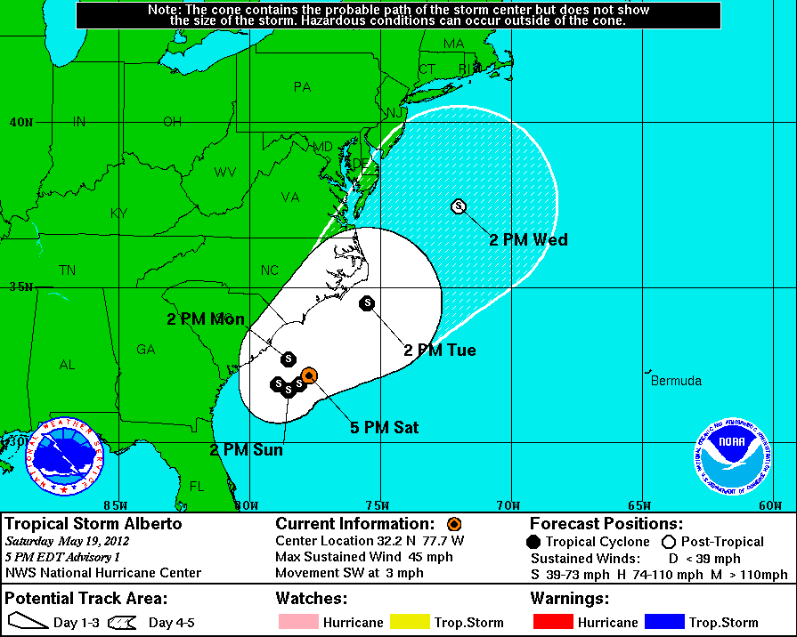
It wouldn't hurt to include an update, this has developed into Tropical Storm Alberto.
5:00 PM EDT Sat May 19
Location: 32.2°N 77.7°W
Max sustained: 45 mph
Moving: SW at 3 mph
Min pressure: 1007 mb
(Source: National Hurricane Center)
It's worth monitoring, but not worth inciting panic. Although this does serve as a reminder, even tropical systems can form with little warning. Landfall is not the time to be gathering emergency supplies!
reply to post by Mapkar
Been out and about all day with the family and haven't had very good signal for iPhone so I've been unable to update. I figured the fine folks of ATS would be on the ball, and it looks like I was correct.
Great job with the updates folks and I will look for more when I get home this evening.
Been out and about all day with the family and haven't had very good signal for iPhone so I've been unable to update. I figured the fine folks of ATS would be on the ball, and it looks like I was correct.
Great job with the updates folks and I will look for more when I get home this evening.
reply to post by jadedANDcynical
You bet!
I believe I'll actually try to keep up with this thread, since I'm in the South Carolina Low Country I'm in the zone for potentially landfalling storms, so I have an interest in these things. I'll also try to toss in my own observations and such on the situation out here.
You bet!
I believe I'll actually try to keep up with this thread, since I'm in the South Carolina Low Country I'm in the zone for potentially landfalling storms, so I have an interest in these things. I'll also try to toss in my own observations and such on the situation out here.
reply to post by jadedANDcynical
sorry didnt see this thread before i posted on the other one yesterday
sorry didnt see this thread before i posted on the other one yesterday
Subtropical Storm Beryl
It's already getting busy...
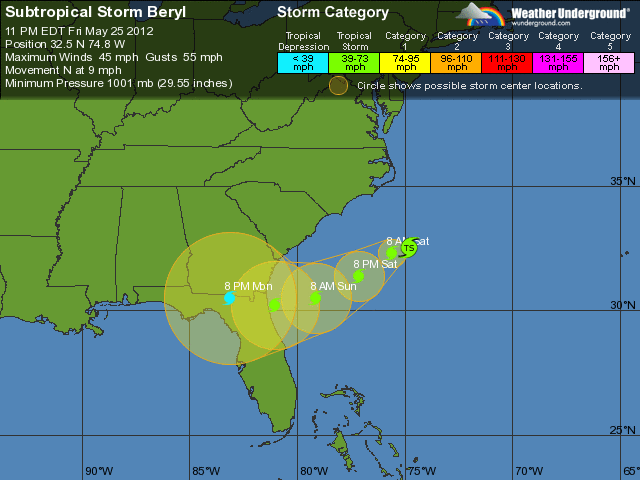
...Subtropical storm forms in the southewestern Atlantic...
...Tropical Storm Warning issued for a portion of the southeastern
U.S. Coast...
summary of 1100 PM EDT...0300 UTC...information
-----------------------------------------------
location...32.5n 74.8w
about 305 mi...490 km E of Charleston South Carolina
maximum sustained winds...45 mph...75 km/h
present movement...N or 10 degrees at 9 mph...15 km/h
minimum central pressure...1001 mb...29.56 inches
It's already getting busy...
reply to post by jadedANDcynical
Hi Jaded...just stumbled upon your thread...do you have info for the northeast this weekend? i heard it might get nasty.
thanks for the info...great work!!!
Hi Jaded...just stumbled upon your thread...do you have info for the northeast this weekend? i heard it might get nasty.
thanks for the info...great work!!!
edit on 26-5-2012 by timetothink because: (no reason given)
reply to post by timetothink
I've really become a fan of WeatherUnderground. They have a local weather option and I have found them to be pretty darned accurate.
I find that Dr. Jeff Masters Blog has some highly knowledgeable people posting on a regular basis (click on the comments), much like here at ATS but geared specifically toward weather.
Glad you like the thread!
edit on 26-5-2012 by jadedANDcynical because: added modifier for where to check on the blog for the smart
cookies...
reply to post by jadedANDcynical
Thank you so much!!
Yet another thread I will be hooked on for the summer!!
Thank you so much!!
Yet another thread I will be hooked on for the summer!!
TS Chris is headed out to the North Atlantic, but Invest 96 is in the GOM and possibly headed to the Florida panhandle:
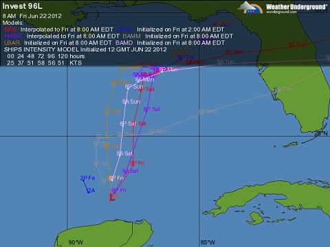
Page at Weatherunderground
Page at Weatherunderground
Invest 96at
Wind: 30 MPH — Location: 22.5 88.3W — Movement: NE
This area of disturbed weather has the potential for tropical development.
reply to post by jadedANDcynical
June 21, 2012 — Chris has been downgraded to a tropical storm, just hours after strengthening into a hurricane on Thursday morning.
"just hours after strengthening into a hurricane",, lol,, ok,, when i read your post i thought i was going nuts,,,last i read,it WAS A hurricane,,,lol,, now completely gone ,,poof,, lol,,
So had too get confirmation.
not nuts.
reply to post by lasertaglover
Its TS Ernesto now. Another one behind it coming off the African coast.
www.nhc.noaa.gov...
Its TS Ernesto now. Another one behind it coming off the African coast.
www.nhc.noaa.gov...
So thus far this Summer I have found it a bit odd at how quiet the Atlantic has been, meanwhile we have seen storm after storm come off the coast of
Mexico. At least for me, I found this pattern to be odd. So after checking the Hurricane Center site to see whats new, imagine my shock as I see
this....
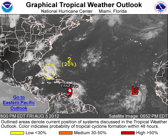
SO we now officially have 2 storms in the Atlantic, and one possibly developing near the Florida coast which is currently at a 20% chance of forming into a named storm.
I hope everyone enjoyed the quiet time, cause it sure looks like we will be a bit busy over the next week or so.
SO we now officially have 2 storms in the Atlantic, and one possibly developing near the Florida coast which is currently at a 20% chance of forming into a named storm.
I hope everyone enjoyed the quiet time, cause it sure looks like we will be a bit busy over the next week or so.
new topics
-
Las Vegas UFO Spotting Teen Traumatized by Demon Creature in Backyard
Aliens and UFOs: 7 minutes ago -
2024 Pigeon Forge Rod Run - On the Strip (Video made for you)
Automotive Discussion: 56 minutes ago -
Gaza Terrorists Attack US Humanitarian Pier During Construction
Middle East Issues: 1 hours ago -
The functionality of boldening and italics is clunky and no post char limit warning?
ATS Freshman's Forum: 2 hours ago -
Meadows, Giuliani Among 11 Indicted in Arizona in Latest 2020 Election Subversion Case
Mainstream News: 3 hours ago -
Massachusetts Drag Queen Leads Young Kids in Free Palestine Chant
Social Issues and Civil Unrest: 3 hours ago -
Weinstein's conviction overturned
Mainstream News: 4 hours ago -
Supreme Court Oral Arguments 4.25.2024 - Are PRESIDENTS IMMUNE From Later Being Prosecuted.
Above Politics: 6 hours ago -
Krystalnacht on today's most elite Universities?
Social Issues and Civil Unrest: 6 hours ago -
Chris Christie Wishes Death Upon Trump and Ramaswamy
Politicians & People: 6 hours ago
top topics
-
Krystalnacht on today's most elite Universities?
Social Issues and Civil Unrest: 6 hours ago, 8 flags -
Weinstein's conviction overturned
Mainstream News: 4 hours ago, 6 flags -
Supreme Court Oral Arguments 4.25.2024 - Are PRESIDENTS IMMUNE From Later Being Prosecuted.
Above Politics: 6 hours ago, 5 flags -
University of Texas Instantly Shuts Down Anti Israel Protests
Education and Media: 8 hours ago, 5 flags -
Massachusetts Drag Queen Leads Young Kids in Free Palestine Chant
Social Issues and Civil Unrest: 3 hours ago, 4 flags -
Meadows, Giuliani Among 11 Indicted in Arizona in Latest 2020 Election Subversion Case
Mainstream News: 3 hours ago, 4 flags -
Chris Christie Wishes Death Upon Trump and Ramaswamy
Politicians & People: 6 hours ago, 2 flags -
Any one suspicious of fever promotions events, major investor Goldman Sachs card only.
The Gray Area: 11 hours ago, 2 flags -
Gaza Terrorists Attack US Humanitarian Pier During Construction
Middle East Issues: 1 hours ago, 2 flags -
2024 Pigeon Forge Rod Run - On the Strip (Video made for you)
Automotive Discussion: 56 minutes ago, 1 flags
active topics
-
Candidate TRUMP Now Has Crazy Judge JUAN MERCHAN After Him - The Stormy Daniels Hush-Money Case.
Political Conspiracies • 779 • : Vermilion -
Supreme Court Oral Arguments 4.25.2024 - Are PRESIDENTS IMMUNE From Later Being Prosecuted.
Above Politics • 60 • : Annee -
University of Texas Instantly Shuts Down Anti Israel Protests
Education and Media • 183 • : Threadbarer -
Las Vegas UFO Spotting Teen Traumatized by Demon Creature in Backyard
Aliens and UFOs • 0 • : FlyersFan -
Breaking Baltimore, ship brings down bridge, mass casualties
Other Current Events • 489 • : Threadbarer -
-@TH3WH17ERABB17- -Q- ---TIME TO SHOW THE WORLD--- -Part- --44--
Dissecting Disinformation • 679 • : McTech2 -
Gaza Terrorists Attack US Humanitarian Pier During Construction
Middle East Issues • 15 • : Irishhaf -
Massachusetts Drag Queen Leads Young Kids in Free Palestine Chant
Social Issues and Civil Unrest • 9 • : theatreboy -
Meadows, Giuliani Among 11 Indicted in Arizona in Latest 2020 Election Subversion Case
Mainstream News • 5 • : Disgusted123 -
God's Righteousness is Greater than Our Wrath
Religion, Faith, And Theology • 29 • : Topcraft