It looks like you're using an Ad Blocker.
Please white-list or disable AboveTopSecret.com in your ad-blocking tool.
Thank you.
Some features of ATS will be disabled while you continue to use an ad-blocker.

Ring of quakes around Yellowstone's magma chamber ?
page: 1share:
I just replied in another thread that there appears
to be a large ring of small earthquakes around
what I think would be the magma chamber of the
super volcano at Yellowstone.
This could be totally normal,
but I don't recall such a smooth
circle over such a large area.
Also didn't recent geological surveys imply
that the magma chamber of the SV @ Yellowstone
covers an area that encompasses the 3 or 4 corners of the
surrounding states?
Like I said this could be quite normal,
but those knowing more, check it out please.
(these earthquakes are in the last week or so)
*Not fear mongering, just want opinions on whether it's odd.
I thought with all the recent threads about volcano's,
FEMA people going on drills etc ,this warranted a
look by members who know a lot more about this than me.
earthquake.usgs.gov...
Link fix?
I cant screen shot because I'm on an iPad.
If someone can it would be greatly appreciated.
These quakes can be seen circling a big chunk
of the states just east of Washington/Oregon .
It can be seen in the "US map" at USGS.
No need to zoom.
edit on 19-2-2012 by sealing because: (no reason given)
edit on 19-2-2012 by sealing because: (no reason given)
i really dont see any activity there.
earthquake.usgs.gov...
this link shows yellowstone.
only a few quakes on the west side but thats about it.
hope this is what you wanted up right?
earthquake.usgs.gov...
this link shows yellowstone.
only a few quakes on the west side but thats about it.
hope this is what you wanted up right?
edit on 19-2-2012 by omegacorps because: add info pic and link
reply to post by sealing
The link is broken and and when it does work you have to click USA on the sidebar and then look. Its like an oval circle around Yellowstone, which I imagine its magma chamber is actually much larger than the caldera itself.
I don't know if this will work
earthquake.usgs.gov...
The link is broken and and when it does work you have to click USA on the sidebar and then look. Its like an oval circle around Yellowstone, which I imagine its magma chamber is actually much larger than the caldera itself.
I don't know if this will work
earthquake.usgs.gov...
reply to post by omegacorps
The map I mean is on a much larger scale than the volcano itself.
It's the magma chamber I'm seeing a circle around .
At the regular USGS site, it can be seen on the US map without zooming.
The map I mean is on a much larger scale than the volcano itself.
It's the magma chamber I'm seeing a circle around .
At the regular USGS site, it can be seen on the US map without zooming.
edit on 19-2-2012 by sealing because: sp
reply to post by ragiusnotiel
Thank you for providing a working link.
I appreciate it very much. And yay, you see it too.
Thank you for providing a working link.
I appreciate it very much. And yay, you see it too.
well i know there has been a magma uplift on the north side of the lake
not sure if thats what your talking about.
not sure if thats what your talking about.
reply to post by omegacorps
Yes,I remember hearing that as well. Thanks for checking it out.
It may be a normal occurrence what I'm seeing.
It's just such a large ring of quakes, with the volcano's
caldera being pretty close to center of the circle.
Yes,I remember hearing that as well. Thanks for checking it out.
It may be a normal occurrence what I'm seeing.
It's just such a large ring of quakes, with the volcano's
caldera being pretty close to center of the circle.
reply to post by sealing
Here's a new (2009) 3D image of yellowstones magma chamber.
news.nationalgeographic.com...
The little red outline at the top is the caldera.
Gives a better perspective on the size of it.
Here's a new (2009) 3D image of yellowstones magma chamber.
news.nationalgeographic.com...
The little red outline at the top is the caldera.
Gives a better perspective on the size of it.
That thing is so huge that if it blows up at least we get to know if the hollow earth theory is right or wrong...
reply to post by sealing
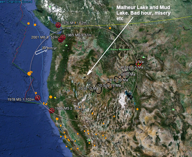
I noticed this ring the other day. They do happen quite often and don't think it is centred on the magma chamber. More curiously it seems to be more or less centred on Malheur Lake. A curious name indeed. Literally "bad hour" but translates to misery, misfortune or adversity. A portend of impending doom perhaps?
Nothing good can come of that.
The model shows that a 45-mile-wide (72-kilometer-wide) plume of hot, molten rock rises to feed the supervolcano from at least 410 miles (660
kilometers) beneath Earth's surface.
The deepest part of the plume actually sits beneath the town of Wisdom, Montana, about 150 miles (241 kilometers) from Yellowstone National Park (see map).
From news.nationalgeographic.com...
Distance on map from yellowstone to wisdom'
maps.google.com...:en-USfficial&client=firefox-a&q=wisdom+montana&um=1&ie=UTF-8&hq=&hnear=0x53597806ba8beaf1:0xb4f a225a532b3c51,Wisdom,+Mt&gl=us&ei=NoRBT-rrIsbY0QHOv5ngBw&sa=X&oi=geocode_result&ct=image&resnum=2&ved=0CDsQ8gEwAQ
compared to the original and it is slightly off center. but that's taking the fact that these calculations are correct... after all the USGS did just (2009) find out about 13 additional miles of magma..
Originally posted by FraternitasSaturni
That thing is so huge that if it blows up at least we get to know if the hollow earth theory is right or wrong...
it will be when that thing empty's. lulz
reply to post by sealing
Hi OP. I too have been periodically seeing that larger ring and wondered if it is all related to the supervolcano rather than inland tectonic elevation or individual volcanoes in the area. I wish I knew more about this science.
Hi OP. I too have been periodically seeing that larger ring and wondered if it is all related to the supervolcano rather than inland tectonic elevation or individual volcanoes in the area. I wish I knew more about this science.
If smth's gonna happen why are they building such a connection of underground passages? Isn't earthquakes, magma firstly going to start there?
Originally posted by ragiusnotiel
reply to post by sealing
Here's a new (2009) 3D image of yellowstones magma chamber.
news.nationalgeographic.com...
The little red outline at the top is the caldera.
Gives a better perspective on the size of it.
Wow ! Amazing! Thank you so much for bringing this link in.
It helps me see it in a whole new way. I deem thee awesome.
reply to post by PuterMan
Yay! I got Puterman to check out my query .
I know that makes me sound like a dork,
but you were just the guy I was thinking of
when I said I wanted 1 of our more knowledgeable
members to have a look at this.
Yay! I got Puterman to check out my query .
I know that makes me sound like a dork,
but you were just the guy I was thinking of
when I said I wanted 1 of our more knowledgeable
members to have a look at this.
Originally posted by aboutface
reply to post by sealing
Hi OP. I too have been periodically seeing that larger ring and wondered if it is all related to the supervolcano rather than inland tectonic elevation or individual volcanoes in the area. I wish I knew more about this science.
Yeah that sucker has had my attention for a while now. As one new member sleuth
has shown in their link, the magma chamber is at least 45 miles wide and at least 410 miles
deep ! And, the escape hole is Yellowstone National Park. That amount of lava is hard for
my brain to wrap around.
reply to post by Imtor
Ha! That's exactly right!
Great point. God knows what passages
natural or otherwise are under the western half of the US.
Just waiting to funnel rock so hot it's liquid who knows where?
Ha! That's exactly right!
Great point. God knows what passages
natural or otherwise are under the western half of the US.
Just waiting to funnel rock so hot it's liquid who knows where?
Originally posted by sealing
reply to post by Imtor
Ha! That's exactly right!
Great point. God knows what passages
natural or otherwise are under the western half of the US.
Just waiting to funnel rock so hot it's liquid who knows where?
From all these underground bases, an earthquakes or movement of the plates and it will become like a dug anthill. All inside and below will be seen. ;>
new topics
-
God's Righteousness is Greater than Our Wrath
Religion, Faith, And Theology: 41 minutes ago -
Electrical tricks for saving money
Education and Media: 3 hours ago -
VP's Secret Service agent brawls with other agents at Andrews
Mainstream News: 5 hours ago -
Sunak spinning the sickness figures
Other Current Events: 5 hours ago -
Nearly 70% Of Americans Want Talks To End War In Ukraine
Political Issues: 5 hours ago -
Late Night with the Devil - a really good unusual modern horror film.
Movies: 7 hours ago -
Cats Used as Live Bait to Train Ferocious Pitbulls in Illegal NYC Dogfighting
Social Issues and Civil Unrest: 9 hours ago -
The Good News According to Jesus - Episode 1
Religion, Faith, And Theology: 11 hours ago
top topics
-
Florida man's trip overseas ends in shock over $143,000 T-Mobile phone bill
Social Issues and Civil Unrest: 16 hours ago, 8 flags -
Cats Used as Live Bait to Train Ferocious Pitbulls in Illegal NYC Dogfighting
Social Issues and Civil Unrest: 9 hours ago, 8 flags -
VP's Secret Service agent brawls with other agents at Andrews
Mainstream News: 5 hours ago, 8 flags -
Bobiverse
Fantasy & Science Fiction: 16 hours ago, 3 flags -
HORRIBLE !! Russian Soldier Drinking Own Urine To Survive In Battle
World War Three: 13 hours ago, 3 flags -
Electrical tricks for saving money
Education and Media: 3 hours ago, 3 flags -
Nearly 70% Of Americans Want Talks To End War In Ukraine
Political Issues: 5 hours ago, 3 flags -
Sunak spinning the sickness figures
Other Current Events: 5 hours ago, 3 flags -
Late Night with the Devil - a really good unusual modern horror film.
Movies: 7 hours ago, 2 flags -
The Good News According to Jesus - Episode 1
Religion, Faith, And Theology: 11 hours ago, 1 flags
active topics
-
VP's Secret Service agent brawls with other agents at Andrews
Mainstream News • 34 • : WeMustCare -
New whistleblower Jason Sands speaks on Twitter Spaces last night.
Aliens and UFOs • 53 • : pianopraze -
Sunak spinning the sickness figures
Other Current Events • 5 • : glen200376 -
SETI chief says US has no evidence for alien technology. 'And we never have'
Aliens and UFOs • 44 • : MikeDeGrasseTyson -
HORRIBLE !! Russian Soldier Drinking Own Urine To Survive In Battle
World War Three • 31 • : budzprime69 -
How ageing is" immune deficiency"
Medical Issues & Conspiracies • 33 • : rickymouse -
The Reality of the Laser
Military Projects • 46 • : Zaphod58 -
God's Righteousness is Greater than Our Wrath
Religion, Faith, And Theology • 0 • : randomuser2034 -
President BIDEN Vows to Make Americans Pay More Federal Taxes in 2025 - Political Suicide.
2024 Elections • 136 • : ImagoDei -
Electrical tricks for saving money
Education and Media • 3 • : Mike72