It looks like you're using an Ad Blocker.
Please white-list or disable AboveTopSecret.com in your ad-blocking tool.
Thank you.
Some features of ATS will be disabled while you continue to use an ad-blocker.

CALIPSO - the logistical arm of aerial spraying?
page: 1share:
What is logistics? All three definitions from thefreedictionary apply here:
www.thefreedictionary.com...
A number of us have observed an aerial spraying program by looking up. How is this program co-ordinated? How does this program ensure that metropolitan areas globally receive adequate cirrus coverage? How is adequate measured and determined? In other words - who is remotely observing the field of battle and issuing commands?
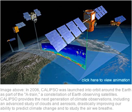
What is CALIPSO? It is the 'Cloud-Aerosol Lidar and Infrared Pathfinder Satellite Observation' project.
www-calipso.larc.nasa.gov...
What is lidar? It's essentially a system of sending out light and getting a return which can 'see' things that radar can't.
www.wordiq.com...
CALIPSO was launched in 2006 - a collaboration between the U.S. and France. CALIPSO operates in tandem with CloudSat. What is CloudSat?
www.nasa.gov...
It's another satellite operating with CALIPSO and is part of what NASA calls the 'A-Train' constellation which includes 3 other satellites. It helps in measuring the vertical height of clouds. These satellites are in a polar orbit. Together they will:
CALIPSO provides data for scientists and researchers. Interestingly enough this data includes thin clouds and visibility for a number of latitudes and longitudes. It tells us how opaque the clouds are. What is opaque? In this case it's how easy or difficult the clouds are to see through.
www.thefreedictionary.com...
So...here's my take: CALIPSO does not measure water clouds but only ice and aerosol clouds. It is measuring them to see how they affect visibility i.e. 'can you see through them or not.' It's a global system and using their data a person can look around the globe and see where things are obscured and where they are not or how obscure they are.
What's the point? In an aerial spraying effort, which a number of us have observed by looking up, there needs to be a point where it is co-ordinated. How will anyone know where to spray and where not if they don't have a map that shows what to do. That's what CALIPSO does. Global coverage is not acheived by hit and miss rogue operations. It is acheived by a systematic real time study of thin cloud opacity and wind currents.
eosweb.larc.nasa.gov...
So here it is - the logistical arm, taxpayer funded, of the aerial spraying program. What do you think?
www.thefreedictionary.com...
1. (Military) the science of the movement, supplying, and maintenance of military forces in the field
2. (Economics) the management of materials flow through an organization, from raw materials through to finished goods
3. the detailed planning and organization of any large complex operation
A number of us have observed an aerial spraying program by looking up. How is this program co-ordinated? How does this program ensure that metropolitan areas globally receive adequate cirrus coverage? How is adequate measured and determined? In other words - who is remotely observing the field of battle and issuing commands?
What is CALIPSO? It is the 'Cloud-Aerosol Lidar and Infrared Pathfinder Satellite Observation' project.
www-calipso.larc.nasa.gov...
CALIPSO combines an active lidar instrument with passive infrared and visible imagers to probe the vertical structure and properties of thin clouds and aerosols over the globe.
What is lidar? It's essentially a system of sending out light and getting a return which can 'see' things that radar can't.
www.wordiq.com...
The primary difference between lidar and radar is that much smaller electromagnetic wavelengths are used. In general it is possible to image a feature or object only about the same size as the wavelength, or larger. Thus lidar is highly sensitive to aerosols and cloud particles and has many applications in atmospheric research and meteorology.
The wavelengths are ideal for making measurements of smoke and other airborne particles (aerosols), clouds, and of air molecules.
CALIPSO was launched in 2006 - a collaboration between the U.S. and France. CALIPSO operates in tandem with CloudSat. What is CloudSat?
www.nasa.gov...
It's another satellite operating with CALIPSO and is part of what NASA calls the 'A-Train' constellation which includes 3 other satellites. It helps in measuring the vertical height of clouds. These satellites are in a polar orbit. Together they will:
- Provide statistics on the vertical structure of clouds around the globe (both missions)
- Provide statistics on the geographic and vertical distribution of aerosols around the globe (CALIPSO)
- Provide estimates of the percentage of Earth's clouds that produce rain (CloudSat)
- Detect subvisible clouds in the upper troposphere and Polar Stratospheric Clouds (CALIPSO)
- Provide vertically-resolved estimates of how much water and ice are in Earth's clouds (CloudSat)
- Detect snowfall from space (CloudSat)
- Estimate how efficiently the atmosphere produces rain from condensates (CloudSat)
- Provide an indirect estimate of how much clouds and aerosols contribute to atmospheric warming (both missions)
CALIPSO provides data for scientists and researchers. Interestingly enough this data includes thin clouds and visibility for a number of latitudes and longitudes. It tells us how opaque the clouds are. What is opaque? In this case it's how easy or difficult the clouds are to see through.
www.thefreedictionary.com...
Impenetrable by light; neither transparent nor translucent.
. Not reflecting light; having no luster: an opaque finish.
Impenetrable by a form of radiant energy other than visible light: a chemical solution opaque to x-rays.
So...here's my take: CALIPSO does not measure water clouds but only ice and aerosol clouds. It is measuring them to see how they affect visibility i.e. 'can you see through them or not.' It's a global system and using their data a person can look around the globe and see where things are obscured and where they are not or how obscure they are.
What's the point? In an aerial spraying effort, which a number of us have observed by looking up, there needs to be a point where it is co-ordinated. How will anyone know where to spray and where not if they don't have a map that shows what to do. That's what CALIPSO does. Global coverage is not acheived by hit and miss rogue operations. It is acheived by a systematic real time study of thin cloud opacity and wind currents.
eosweb.larc.nasa.gov...
So here it is - the logistical arm, taxpayer funded, of the aerial spraying program. What do you think?
They flew blimps over the bp oil spill to do imaging, and I was hoping they'd use lidar/wondered if it would be able to show all the oil...
if it can pass through water anywhere near as well as it can go through air/aerosols, then this would be proof for me...
good post
if it can pass through water anywhere near as well as it can go through air/aerosols, then this would be proof for me...
good post
Originally posted by luxordelphi
So here it is - the logistical arm, taxpayer funded, of the aerial spraying program. What do you think?
I think it's exactly what it says it is. It's a satellite that NASA use to study clouds and aerosols. It's all perfectly well explained on their web site:
www-calipso.larc.nasa.gov...
Measurements from satellites and ground stations show that many aerosols remain in the environment for long periods and can be carried by the winds hundreds of miles from their origin. In other words, the air we breathe is strongly affected by other countries' stewardship of the atmosphere — and vice versa.
To better predict the ultimate fate of aerosols, to help devise strategies for limiting pollution and to improve forecasts of harmful air quality conditions, we need better information on aerosol sources and how they enter the atmosphere and interact with weather patterns.
A key piece of information that is not provided by currently operating observational satellites is the altitude of aerosol layers in the atmosphere. Aerosols confined to the lowest part of the atmosphere are likely to be removed quickly by rain. On the other hand, those that are transported to higher altitudes are much more likely to travel long distances and affect air quality in distant countries. CALIPSO provides this vital missing piece of information.
Obtaining better information on the height of clouds is also needed. At present, weather prediction and climate models have considerable difficulty predicting the coverage, water and ice content and altitude of clouds. Inaccuracies in these parameters can lead to large errors in estimates of precipitation and the strength of the circulation. Observations from CALIPSO provide valuable new information that will help to improve weather and climate forecasts.
edit on 12-2-2012 by Uncinus because: (no reason given)
edit on 12-2-2012 by Uncinus because: (no
reason given)
reply to post by Uncinus
One of the common themes throughout CALIPSO is the measurement of vertical cloud depth and cloud and aerosol cloud opacity. Vertical cloud depth is not accurately measurable by this system because of opacity, software and background problems. It is measureable to a point. That point seems to lose meaning for the measurers when it approaches opacity giving the impression that it is really something else that is being measured. Aerosols and cirrus, on the other hand, don't present a problem with this system.
In the excerpt that you chose, "...we need better information on aerosol sources and how they enter the atmosphere and interact with weather patterns." This is my point - aerosols from jet emissions that create cirrus banks are tracked. This activity can be interpreted in several different ways including the way that I interpreted it.
I appreciate the defense activities implied in the statement from the excerpt you chose, "...the air we breathe is strongly affected by other countries' stewardship of the atmosphere - and vice versa." There are, I believe, still a number of countries that are not a part of NATO and not even a part of Partnership for Peace, which seems to be the bugle call for aerial spraying, however, I am not a fan of the U.S. in the role of bully. And the data from CALIPSO would certainly provide a way around any hold-outs and their airspace by using real time wind currents and aerosol massing. My contention though is that it's not a passive defense but a logistical arm of overt operations already in progress.
Aerosols from jet emissions are a very small fraction of the total aerosols in the atmosphere.
Originally posted by luxordelphi
So...here's my take: CALIPSO does not measure water clouds but only ice and aerosol clouds.
Awesome demonstration that you do not understand the fundamental concepts of what you talk about.
Water clouds ARE aerosol clouds, and ice IS water.
Deny ignorance!
reply to post by luxordelphi
Pardon my ignorance but i haven't heard of this until today, so thank you for sharing
The thread was well put together and contains some very interesting information.
I'm certainly going to look into this in more detail.
Peace.
Pardon my ignorance but i haven't heard of this until today, so thank you for sharing
The thread was well put together and contains some very interesting information.
I'm certainly going to look into this in more detail.
Peace.
reply to post by Corruption Exposed
Thx CE and thx for stopping by. I was actually in another thread last night and came across this information during some searches. It seemed like the perfect set-up. There were also some threatening leaked e-mails, U.S. to France, some time back that might explain the collaboration on CALIPSO but I have to dig those out yet.
I had been researching delivery systems for awhile, just because the technology is so different now then even 5 years ago and there is always the question of well... how do they know when and where to spray?
CALIPSO seemed to answer this question and I was looking for some feedback on what others thought.
edit on 12-2-2012 by luxordelphi because: space out last sentence
OP --
I don't see the necessary connection between the study of aerosol pollution and chemtrails.
Obviously the aerosols being pumped into our atmosphere from cars and industrial emissions make up a huge percentage of all airborne aerosols. Why do you not believe that CALIPSO isn't simply studying those aerosol emissions?
Even if we stipulate for a moment for the sake of argument that chemtrail spraying is actually a real thing, how do you propose to link CALIPSO to the study of chemtrails rather than simply the study of all of other airborne aerosols (which are far greater in volume than trails from planes).
reply to post by 1825114
Your post - such a good post!! - stumped me. Here's a link showing what is alleged to be the use of lidar by NASA shortly after the Gulf oil spill in a fly-by (?). They attach a video which doesn't seem to say anything about lidar at all unless it has different names.
blog.lidarnews.com...
As far as the ability of lidar to go through water - there seems to be some difficulty in seeing through clouds with rain potential but not in seeing through ice crystals. I know nothing about lidar except what I found a couple of nights ago and read preparing this thread. I don't know if it's the way the software is set-up or if lidar itself is not suited to water. On one of the site pages instructing researchers wanting to use the data they say this:
eosweb.larc.nasa.gov...
There is also a brief explanation and cool semi-interactive graphic showing what looks like a huge amount of cirrus over Australia, Asia and Indonesia from 2006.
www.nasa.gov...
Your post - such a good post!! - stumped me. Here's a link showing what is alleged to be the use of lidar by NASA shortly after the Gulf oil spill in a fly-by (?). They attach a video which doesn't seem to say anything about lidar at all unless it has different names.
blog.lidarnews.com...
As far as the ability of lidar to go through water - there seems to be some difficulty in seeing through clouds with rain potential but not in seeing through ice crystals. I know nothing about lidar except what I found a couple of nights ago and read preparing this thread. I don't know if it's the way the software is set-up or if lidar itself is not suited to water. On one of the site pages instructing researchers wanting to use the data they say this:
eosweb.larc.nasa.gov...
the CALIOP extinction retrieval algorithm was developed for retrievals of aerosol and ice clouds, not water clouds.
this value appears to be appropriate for semitransparent water clouds (? < 1). (It is purely coincidental this is the same value used for ice clouds.) For denser water clouds (? > 1) the multiply-scattered component of the signal becomes much larger than the single-scattered component, ?532 becomes dependent on both cloud extinction and range into the cloud, and the retrieval becomes very sensitive to errors
There is also a brief explanation and cool semi-interactive graphic showing what looks like a huge amount of cirrus over Australia, Asia and Indonesia from 2006.
www.nasa.gov...
The lidar emits short pulses of green and infrared light -- rather than the microwaves used by radar -- which are reflected from cloud and aerosol particles in the atmosphere.
Each lidar sample produces a 300-feet wide snapshot or profile of the atmosphere. Profiles collected along an orbit are streamed together to paint a picture of what a vertical slice of our atmosphere looks like.
Originally posted by Uncinus
Aerosols from jet emissions are a very small fraction of the total aerosols in the atmosphere.
Aerosols from jet emissions appear to be the only aerosols triggering banks of cirrus over metropolitan areas as evidenced in photos and personal observations. CALIPSO tracks aerosols and thin clouds not capable of producing rain. I have to observe here that it seems like a lot of expense and effort in order to track and observe persistent contrails. Where's the excitement in this?
I've given my reasons and they are that different particles create different effects in the atmosphere and along with a logistics system that tracks what's been done where it tracks also what particles have been used where and what effect as opposed to other particles it has.
Originally posted by Aloysius the Gaul
Originally posted by luxordelphi
So...here's my take: CALIPSO does not measure water clouds but only ice and aerosol clouds.
Awesome demonstration that you do not understand the fundamental concepts of what you talk about.
Water clouds ARE aerosol clouds, and ice IS water.
Deny ignorance!
Gaul: you impish derailer..please see my reply to 1825114. I'm not making this stuff up but rather reading it from the site itself. So I'm going to have to say: take your water-ice deny ignorance fundamental concept up with CALIPSO.
Originally posted by luxordelphi
Originally posted by Uncinus
Aerosols from jet emissions are a very small fraction of the total aerosols in the atmosphere.
Aerosols from jet emissions appear to be the only aerosols triggering banks of cirrus over metropolitan areas as evidenced in photos and personal observations. CALIPSO tracks aerosols and thin clouds not capable of producing rain. I have to observe here that it seems like a lot of expense and effort in order to track and observe persistent contrails. Where's the excitement in this?
It's not the aerosols in jet emissions that triggers the contrails (and sometime contrail cirrus), it's the water. The additional aerosols simply increase the number of initial ice crystals.
The site gives very clear explanations as to what the CALIPSO program is about. Contrails are just a very small part of it.
Originally posted by luxordelphi
Originally posted by Aloysius the Gaul
Originally posted by luxordelphi
So...here's my take: CALIPSO does not measure water clouds but only ice and aerosol clouds.
Awesome demonstration that you do not understand the fundamental concepts of what you talk about.
Water clouds ARE aerosol clouds, and ice IS water.
Deny ignorance!
Gaul: you impish derailer..please see my reply to 1825114. I'm not making this stuff up but rather reading it from the site itself. So I'm going to have to say: take your water-ice deny ignorance fundamental concept up with CALIPSO.
Nope - you repeated it as your own words - I see where the Calipso document says "clouds and aerosols" in a couple of places, and perhaps they have a reason for that - I couldn't find it - but you still have the ability to show good understanding in your own writing.
But you don't.
reply to post by 1825114
Hi again 1825114: did a little more follow-up on your terribly interesting observation. Apparently lidar can be used to measure water depth but only to 50 meters (164 feet.)
www.metric-conversions.org...
From the NOAA site on lidar:
www.nauticalcharts.noaa.gov...
The depth for the Gulf oil spill is 1500 meters (5,000 feet.)
en.wikipedia.org...
As far as a laser being able to travel through water:
www.answerbag.com...
How this might relate to lidar imaging the oil spill under so much water - it's a good question but I'd have to say you've got to get through the water first.
Hi again 1825114: did a little more follow-up on your terribly interesting observation. Apparently lidar can be used to measure water depth but only to 50 meters (164 feet.)
www.metric-conversions.org...
From the NOAA site on lidar:
www.nauticalcharts.noaa.gov...
LIght Detection And Ranging, or LIDAR, is a method used by NOAA's contractors to measure elevation or depth by analyzing pulses of laser light reflected off an object. These survey systems are typically aircraft-mounted and provide seamless coverage between land and sea. Bathymetric LIDAR refers to its use to determine water depth.
Bathymetric LIDAR systems use laser pulses received at two frequencies. Water depths are determined by measuring the time delay between the transmission of a pulse and its return signal detecting the seafloor. A lower frequency infrared pulse is reflected off the sea surface, while a higher frequency green laser penetrates through the water column and reflects off the bottom.
Analyses of these two distinct pulses are used to establish water depths and shoreline elevations. Depending on water clarity, these systems can reach depths of 50 meters.
The depth for the Gulf oil spill is 1500 meters (5,000 feet.)
en.wikipedia.org...
At the time of the explosion, it was drilling an exploratory well at a water depth of approximately 5,000 feet (1,500 m) in the Macondo Prospect, located in the Mississippi Canyon Block 252 of the Gulf of Mexico in the United States exclusive economic zone about 41 miles (66 km) off the Louisiana coast.
As far as a laser being able to travel through water:
www.answerbag.com...
Lasers directed into water will experience both reflection (light being reflected off the surface of the water) and refraction (the bending of the ray when it enters the water). Under conditions permitting visibility, the laser beam will seem to bend as it enters the water.
How this might relate to lidar imaging the oil spill under so much water - it's a good question but I'd have to say you've got to get through the water first.
reply to post by Soylent Green Is People
Dear Soylent Green Is People: thx for your contribution to this thread. The points you raise are good points and need to be addressed if I'm going to make a case here.
Because they are studying thin clouds - cirrus.
www.agu.org...
Because they are studying cirrus (leaving out the real time functions availabe through this system), they are studying chemtrails or persistant contrails caused by jet emissions. Further they are studying the height and vertical depth and opacity of cirrus. There has to be a reason for all this activity and my reason, a logistical way to track product, needs to be shot down with vigor and reason or be entertained.
Dear Soylent Green Is People: thx for your contribution to this thread. The points you raise are good points and need to be addressed if I'm going to make a case here.
Obviously the aerosols being pumped into our atmosphere from cars and industrial emissions make up a huge percentage of all airborne aerosols. Why do you not believe that CALIPSO isn't simply studying those aerosol emissions?
Because they are studying thin clouds - cirrus.
www.agu.org...
The need to better characterize the global distribution of cirrus clouds was therefore a major justification for the formation flying of the CloudSat and CALIPSO satellites, which support a cloud radar and polarization lidar, respectively.
Measurements by these active remote sensors, when analyzed by appropriate algorithms, have the ability to identify and accurately measure the locations and heights of this category of clouds.
The combined CloudSat/Cloud-Aerosol Lidar and Infrared Pathfinder Satellite Observations (CALIPSO) data cirrus cloud algorithm used in this study is aimed at identifying those clouds that would likely be classified as cirrus by a surface weather observer
how do you propose to link CALIPSO to the study of chemtrails rather than simply the study of all of other airborne aerosols
Because they are studying cirrus (leaving out the real time functions availabe through this system), they are studying chemtrails or persistant contrails caused by jet emissions. Further they are studying the height and vertical depth and opacity of cirrus. There has to be a reason for all this activity and my reason, a logistical way to track product, needs to be shot down with vigor and reason or be entertained.
reply to post by Uncinus
I'm going to have to say no to that one.
www.ncbi.nlm.nih.gov...
www.thefreedictionary.com...
chemistry.about.com...
www.toolingu.com...
www.chemicool.com...
www.answers.com...
I'm going to have to go with no on this one too.
www.agu.org...
It's not the aerosols in jet emissions that triggers the contrails (and sometime contrail cirrus), it's the water. The additional aerosols simply increase the number of initial ice crystals.
I'm going to have to say no to that one.
www.ncbi.nlm.nih.gov...
Measurements support that cirrus formation occurs both by heterogeneous nucleation by insoluble particles and homogeneous (spontaneous) freezing of particles containing solutions.
Heterogeneous ice nuclei concentrations in the cirrus regime depend on temperature, relative humidity, and the concentrations and physical and chemical properties of aerosol particles.
Considering previous modeling studies, this result suggests a predominant potential impact of these nuclei on cirrus formed by slow, large-scale lifting or small cooling rates, including subvisual cirrus.
The most common heterogeneous ice nuclei were identified as relatively pure mineral dusts and metallic particles, some of which may have origin through anthropogenic processes.
Homogeneous freezing of large numbers of particles was detected above a critical relative humidity along with a simultaneous transition in nuclei composition toward that of the sulfate-dominated total aerosol population.
Heterogeneous ice nucleation in particles that are wholly insoluble or partially soluble can potentially cause cirrus formation at warmer temperatures and lower relative humidity
www.thefreedictionary.com...
heterogeneous: Consisting of dissimilar elements or parts; not homogeneous.
chemistry.about.com...
nucleation: Nucleation is the process where droplets of liquid can condense from a vapor, or bubbles of gas can form in a boiling liquid. Nucleation can also occur in crystal solution to grow new crystals.
Examples: Dust and pollutants provide nucleation sites for water vapor in the atmosphere to form clouds.
www.toolingu.com...
insoluble: A substance that cannot be dissolved. Pigments used in coatings are insoluble particles.
www.chemicool.com...
homogenous: A substance or material that contains only one kind of compound or one element can be defined as homogeneous. Homogeneous is Latin for "the same kind".
An example of a homogeneous substance would be pure water
www.answers.com...
anthropogenic: Of or relating to anthropogenesis. Caused by humans: anthropogenic degradation of the environment.
The site gives very clear explanations as to what the CALIPSO program is about. Contrails are just a very small part of it.
I'm going to have to go with no on this one too.
www.agu.org...
The need to better characterize the global distribution of cirrus clouds was therefore a major justification for the formation flying of the CloudSat and CALIPSO satellites, which support a cloud radar and polarization lidar, respectively.
reply to post by Aloysius the Gaul
Is CALIPSO speaking to us in metaphors? They style themselves as a science site. Not a poetry site.
eosweb.larc.nasa.gov...
Is this distinction then not a real distinction? Give me a clue then - what do they mean; what do you mean? How was I wrong in interpreting a distinction from the CALIPSO site between ice clouds and water clouds? If it's poetry - I'm lost before we even begin but if they meant what they said, literally, I have a chance.
Nope - you repeated it as your own words - I see where the Calipso document says "clouds and aerosols" in a couple of places, and perhaps they have a reason for that - I couldn't find it - but you still have the ability to show good understanding in your own writing. But you don't.
Is CALIPSO speaking to us in metaphors? They style themselves as a science site. Not a poetry site.
eosweb.larc.nasa.gov...
the CALIOP extinction retrieval algorithm was developed for retrievals of aerosol and ice clouds, not water clouds.
Is this distinction then not a real distinction? Give me a clue then - what do they mean; what do you mean? How was I wrong in interpreting a distinction from the CALIPSO site between ice clouds and water clouds? If it's poetry - I'm lost before we even begin but if they meant what they said, literally, I have a chance.
reply to post by luxordelphi
I suppose CALIPSO could in part be studying aerosols from jet engine exhaust, but aerosol particulates from non-jet sources (industrial emissions and automobile emissions) are omnipresent in the atmosphere, and cirrus clouds could also form around them. These are a great concern to climate-change scientists.
Perhaps studying jet engine emissions is a part of this, but you make it sound like it is the only thing they could possibly be studying...and even if they are studying aerosols from jet engines, what does that have to do with the intentional spraying of chemicals (for the express reason of spraying chemicals), which is how most people define chemtrails?
It seems to me that CALIPSO is simply studying ALL aerosols, plus the cirrus clouds that condense and freeze around these aerosols, in the name of climate change research. I just don't see the smoking gun you seem to see about this being evidence of intentional chemical spraying...
...The bottom line here is that there are reasons to study aerosol particulates in cirrus clouds that have nothing to do with the cirrus clouds that form from contrails. Even if they were studying the climate effects of contrail-produced-cirrus clouds, how is that proof of nefarious intent?
reply to post by Soylent Green Is People
I think I've shown that CALIPSO is studying cirrus and if CALIPSO is studying cirrus they are studying cirrus aviaticus (cirrus created from jet emissions) because CALIPSO would be hard pressed to find natural cirrus these days. There was a thread recently wherein the OP or a poster put up pictures of cirrus aviaticus and to contrast put in a picture of natural cirrus. The difference was startling. The natural cirrus formation was so beautiful and I had completely forgotten what it looked like because it's been so long since I personally have seen it. CALIPSO states they are studying thin clouds and this also points to cirrus aviaticus.
I don't know on this one. I agree that there are multitudes of aerosol particles in the air. What the concentrations are I don't know. As far as spontaneous cirrus formation from these - I haven't seen it. I haven't seen cirrus forming in the wake of automobiles or buses or trains. I haven't seen cirrus form from smokestacks or other emission points. I've daily seen cirrus form from what looks like the wake of jets. And I've seen haze form and spread from what looks like the wake of jets and this would also be classed as thin clouds which is what CALIPSO is tracking.
CALIPSO talks about 'aerosol and ice clouds.' Do they mean aerosol clouds and ice clouds as separate items? Or do they mean clouds composed of aerosol and ice? Gaul brought up a good point in this thread and I think the distinction here is that CALIPSO is tracking artificially created clouds - clouds created by aerosols - not natural clouds. The cycle in nature seems to have been that when aerosols from volcanos etc. get into the atmosphere they saturate the atmosphere and it rains, clearing the air. With these artificial clouds, it doesn't rain. Lidar itself from what I've read is not a perfect tool for studying water. There are escalating errors in the data that lidar returns from what CALIPSO calls 'water clouds."
The first statement that CALIPSO gives as far as aims is that they will provide statistics on the vertical structure of clouds around the globe. Yet, the data is no good beyond a certain point as far as vertical height when dealing with what they call 'water clouds.' So that right there is a red flag for me.
The contention has been that the intentional injection into the atmosphere of particles aimed at protecting us from solar radiation or whatever has only been talked about but not done. My contention is that it's already happening, been happening and the aerosol particle of choice is fluid and experimental and that CALIPSO with its' ability to track aerosol particles and clouds of aerosol particles around the globe is an integral part of this program.
CALIPSO is studying thin clouds.
www.agu.org...
I'm not putting CALIPSO forward as the smoking gun evidence of chemtrail spraying (although I reserve the right to do that at some later date.) That evidence already exists and is available to anyone looking up on almost any given day. I'm saying that CALIPSO is the perfect logistical tool with the ability to determine where the artificial clouds are and where they're going and how opaque they are and how tall they are. They track the various particles and supply information on them in a 3-dimensional grid. This is necessary for an organized spraying method with intentions of global coverage. (see next post - ran out of room)
I suppose CALIPSO could in part be studying aerosols from jet engine exhaust,
I think I've shown that CALIPSO is studying cirrus and if CALIPSO is studying cirrus they are studying cirrus aviaticus (cirrus created from jet emissions) because CALIPSO would be hard pressed to find natural cirrus these days. There was a thread recently wherein the OP or a poster put up pictures of cirrus aviaticus and to contrast put in a picture of natural cirrus. The difference was startling. The natural cirrus formation was so beautiful and I had completely forgotten what it looked like because it's been so long since I personally have seen it. CALIPSO states they are studying thin clouds and this also points to cirrus aviaticus.
but aerosol particulates from non-jet sources (industrial emissions and automobile emissions) are omnipresent in the atmosphere, and cirrus clouds could also form around them.
I don't know on this one. I agree that there are multitudes of aerosol particles in the air. What the concentrations are I don't know. As far as spontaneous cirrus formation from these - I haven't seen it. I haven't seen cirrus forming in the wake of automobiles or buses or trains. I haven't seen cirrus form from smokestacks or other emission points. I've daily seen cirrus form from what looks like the wake of jets. And I've seen haze form and spread from what looks like the wake of jets and this would also be classed as thin clouds which is what CALIPSO is tracking.
CALIPSO talks about 'aerosol and ice clouds.' Do they mean aerosol clouds and ice clouds as separate items? Or do they mean clouds composed of aerosol and ice? Gaul brought up a good point in this thread and I think the distinction here is that CALIPSO is tracking artificially created clouds - clouds created by aerosols - not natural clouds. The cycle in nature seems to have been that when aerosols from volcanos etc. get into the atmosphere they saturate the atmosphere and it rains, clearing the air. With these artificial clouds, it doesn't rain. Lidar itself from what I've read is not a perfect tool for studying water. There are escalating errors in the data that lidar returns from what CALIPSO calls 'water clouds."
The first statement that CALIPSO gives as far as aims is that they will provide statistics on the vertical structure of clouds around the globe. Yet, the data is no good beyond a certain point as far as vertical height when dealing with what they call 'water clouds.' So that right there is a red flag for me.
Perhaps studying jet engine emissions is a part of this, but you make it sound like it is the only thing they could possibly be studying...and even if they are studying aerosols from jet engines, what does that have to do with the intentional spraying of chemicals (for the express reason of spraying chemicals), which is how most people define chemtrails?
The contention has been that the intentional injection into the atmosphere of particles aimed at protecting us from solar radiation or whatever has only been talked about but not done. My contention is that it's already happening, been happening and the aerosol particle of choice is fluid and experimental and that CALIPSO with its' ability to track aerosol particles and clouds of aerosol particles around the globe is an integral part of this program.
It seems to me that CALIPSO is simply studying ALL aerosols, plus the cirrus clouds that condense and freeze around these aerosols, in the name of climate change research. I just don't see the smoking gun you seem to see about this being evidence of intentional chemical spraying...
CALIPSO is studying thin clouds.
www.agu.org...
The combined CloudSat/Cloud-Aerosol Lidar and Infrared Pathfinder Satellite Observations (CALIPSO) data cirrus cloud algorithm used in this study is aimed at identifying those clouds that would likely be classified as cirrus by a surface weather observer:
I'm not putting CALIPSO forward as the smoking gun evidence of chemtrail spraying (although I reserve the right to do that at some later date.) That evidence already exists and is available to anyone looking up on almost any given day. I'm saying that CALIPSO is the perfect logistical tool with the ability to determine where the artificial clouds are and where they're going and how opaque they are and how tall they are. They track the various particles and supply information on them in a 3-dimensional grid. This is necessary for an organized spraying method with intentions of global coverage. (see next post - ran out of room)
new topics
-
George Knapp AMA on DI
Area 51 and other Facilities: 39 minutes ago -
Not Aliens but a Nazi Occult Inspired and then Science Rendered Design.
Aliens and UFOs: 48 minutes ago -
Louisiana Lawmakers Seek to Limit Public Access to Government Records
Political Issues: 3 hours ago -
The Tories may be wiped out after the Election - Serves them Right
Regional Politics: 4 hours ago -
So I saw about 30 UFOs in formation last night.
Aliens and UFOs: 6 hours ago -
Do we live in a simulation similar to The Matrix 1999?
ATS Skunk Works: 7 hours ago -
BREAKING: O’Keefe Media Uncovers who is really running the White House
US Political Madness: 7 hours ago -
Biden--My Uncle Was Eaten By Cannibals
US Political Madness: 8 hours ago -
"We're All Hamas" Heard at Columbia University Protests
Social Issues and Civil Unrest: 8 hours ago -
The good, the Bad and the Ugly!
Diseases and Pandemics: 10 hours ago
top topics
-
BREAKING: O’Keefe Media Uncovers who is really running the White House
US Political Madness: 7 hours ago, 22 flags -
Biden--My Uncle Was Eaten By Cannibals
US Political Madness: 8 hours ago, 18 flags -
African "Newcomers" Tell NYC They Don't Like the Free Food or Shelter They've Been Given
Social Issues and Civil Unrest: 13 hours ago, 12 flags -
George Knapp AMA on DI
Area 51 and other Facilities: 39 minutes ago, 9 flags -
Two Serious Crimes Committed by President JOE BIDEN that are Easy to Impeach Him For.
US Political Madness: 16 hours ago, 9 flags -
911 emergency lines are DOWN across multiple states
Breaking Alternative News: 16 hours ago, 7 flags -
"We're All Hamas" Heard at Columbia University Protests
Social Issues and Civil Unrest: 8 hours ago, 7 flags -
Russia Flooding
Fragile Earth: 15 hours ago, 6 flags -
Russian intelligence officer: explosions at defense factories in the USA and Wales may be sabotage
Weaponry: 12 hours ago, 5 flags -
So I saw about 30 UFOs in formation last night.
Aliens and UFOs: 6 hours ago, 5 flags
active topics
-
"We're All Hamas" Heard at Columbia University Protests
Social Issues and Civil Unrest • 110 • : FlyersFan -
Candidate TRUMP Now Has Crazy Judge JUAN MERCHAN After Him - The Stormy Daniels Hush-Money Case.
Political Conspiracies • 360 • : Sookiechacha -
George Knapp AMA on DI
Area 51 and other Facilities • 5 • : NoCorruptionAllowed -
Mood Music Part VI
Music • 3056 • : Hellmutt -
So I saw about 30 UFOs in formation last night.
Aliens and UFOs • 18 • : KKLOCO -
Do we live in a simulation similar to The Matrix 1999?
ATS Skunk Works • 19 • : purplemer -
Trump To Hold Dinner with President of Poland At Trump Tower Tonight
2024 Elections • 38 • : fringeofthefringe -
The Acronym Game .. Pt.3
General Chit Chat • 7726 • : bally001 -
Russian intelligence officer: explosions at defense factories in the USA and Wales may be sabotage
Weaponry • 160 • : BernnieJGato -
Biden--My Uncle Was Eaten By Cannibals
US Political Madness • 38 • : YourFaceAgain