It looks like you're using an Ad Blocker.
Please white-list or disable AboveTopSecret.com in your ad-blocking tool.
Thank you.
Some features of ATS will be disabled while you continue to use an ad-blocker.

Deep Tremors and Big Earthquakes
page: 1share:
Hi all. I came across something today that I think warrants further investigation. It is possble that deep tremor activity is directly connected to
upper crust EQs in subduction zones in a way that can be used for prediction purposes.
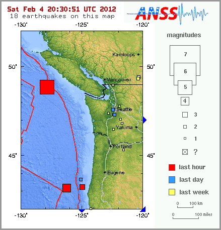
Yesterday we had a 5.7M EQ off Vancouver Island. It was both preceded and followed by a series of deep tremors both in their normal location onshore, as well as midway between the swarm and the main quake offshore.
old.pnsn.org...
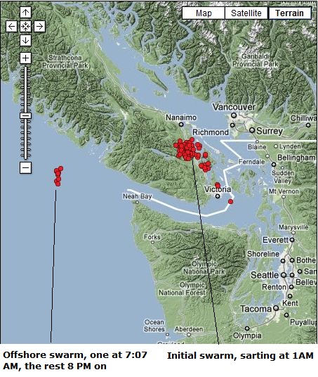
The initial swarm was started at 1AM on the 4th with the center of the swarm at approximately 48.9 lat and 123.8 long. These tremors were probably caused by the leading edge of the Juan de Fuca plate as it subducts under the North American plate. This would be the area that has subducted and is beginning to melt and break free from the plate, moving into the asthenosphere.
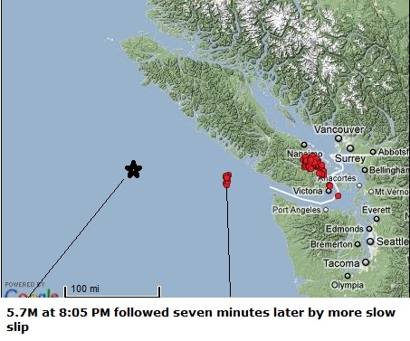
At 7:07 AM a slow slip tremor occurred east of the swarm at 48.6 lat and 125.9 long. At 8:05 PM, a 5.7M hit at 48.8 lat and 127.8 long. This was then followed 7 minutes later with some more slow slip activity occurring at the site of the 7:07 tremor, with only one slow slip tremor occurring at the original onshore swarm site from this point on.
The main swarm was at 123.8 long, the mid swarm at 125.9 long, and the main quake at 127.8 long. A coincidence? Maybe yes, maybe no. I can't remember a pattern like this but it's only been recently that Ive been following swarms. I'm pretty sure the mid swarm is a foreshock with later aftershocks starting right after the main quake.
With subduction zones these slow slips are caused by the end of the slab melting and pulling away. At the same time this is creating added pressure at the lock points offshore. If when the tremors and subsequent pulling away/melting are occurring, and this is pulling at the rest of the slab, it stands to reason that this is creating a time of stress from plates end to the locked point. When the slow slip happened at 7:07, it was odd, cause Ive never seen just one pop up like that offshore. It was Im assuming the fabric of the plate starting to tear but didn't have enough oomph. It was pulling on the lock point, which then gave and allowed there to be a series of tremors at the midway site, equalizing pressure. It's definately within reason.
It might be worth checking to see if this pattern of a tear or slow slip occurring mid way between a swarm and the main quake has happened before anywhere these tremors are monitored. I know the Tohoku earthquake was preceded by a swarm, but I don't know anything else about it. Japan does however monitor tremor activity, so that data should be available.
Yesterday we had a 5.7M EQ off Vancouver Island. It was both preceded and followed by a series of deep tremors both in their normal location onshore, as well as midway between the swarm and the main quake offshore.
old.pnsn.org...
The initial swarm was started at 1AM on the 4th with the center of the swarm at approximately 48.9 lat and 123.8 long. These tremors were probably caused by the leading edge of the Juan de Fuca plate as it subducts under the North American plate. This would be the area that has subducted and is beginning to melt and break free from the plate, moving into the asthenosphere.
At 7:07 AM a slow slip tremor occurred east of the swarm at 48.6 lat and 125.9 long. At 8:05 PM, a 5.7M hit at 48.8 lat and 127.8 long. This was then followed 7 minutes later with some more slow slip activity occurring at the site of the 7:07 tremor, with only one slow slip tremor occurring at the original onshore swarm site from this point on.
The main swarm was at 123.8 long, the mid swarm at 125.9 long, and the main quake at 127.8 long. A coincidence? Maybe yes, maybe no. I can't remember a pattern like this but it's only been recently that Ive been following swarms. I'm pretty sure the mid swarm is a foreshock with later aftershocks starting right after the main quake.
With subduction zones these slow slips are caused by the end of the slab melting and pulling away. At the same time this is creating added pressure at the lock points offshore. If when the tremors and subsequent pulling away/melting are occurring, and this is pulling at the rest of the slab, it stands to reason that this is creating a time of stress from plates end to the locked point. When the slow slip happened at 7:07, it was odd, cause Ive never seen just one pop up like that offshore. It was Im assuming the fabric of the plate starting to tear but didn't have enough oomph. It was pulling on the lock point, which then gave and allowed there to be a series of tremors at the midway site, equalizing pressure. It's definately within reason.
It might be worth checking to see if this pattern of a tear or slow slip occurring mid way between a swarm and the main quake has happened before anywhere these tremors are monitored. I know the Tohoku earthquake was preceded by a swarm, but I don't know anything else about it. Japan does however monitor tremor activity, so that data should be available.
reply to post by zworld
Well done! I'm glad you took westcoasts request to start this thread! I will star and keep my eye on this as I live in Vancouver, BC part time and have been very concerned with this subject for quite some time! Thank you, Nancy
Well done! I'm glad you took westcoasts request to start this thread! I will star and keep my eye on this as I live in Vancouver, BC part time and have been very concerned with this subject for quite some time! Thank you, Nancy
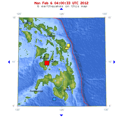
just talking to my wife in the Philippines and a 6.8 went off next island over...she ran outside. Rain is bad...there is going to be a lot of
landslides.
Ive been watching for a few years now and the activity is really picking up.......
im in Vancouver right now following the westcoast threads.....
Ive been watching for a few years now and the activity is really picking up.......
im in Vancouver right now following the westcoast threads.....
Originally posted by The Great Day
just talking to my wife in the Philippines and a 6.8 went off next island over...she ran outside. Rain is bad...there is going to be a lot of landslides.
Ive been watching for a few years now and the activity is really picking up.......
im in Vancouver right now following the westcoast threads.....
Interesting about the Philippines. Im going to check into that one. I believe they have a subduction zone in that area.
Excellent!
Thanks for the info. I have noticed links between the deep tremors and quakes for awhile now and have suggested as such in my deep tremor threads (see link in sig), but I think that this is the best correllation.
Great job in narrowing down the tremor times/location vs the quake. Only problem, is that there are usually SO many tremors, it is hard to make an accurate prediction, without making at least one a day. This one was more obvious because we haven't had any deep tremors for several days previously, which always makes me suspect something is coming.
Working on a little idea,,
at 28 miles deep ,, the 6.8,,
with the pressures involved on the Magma at that depth,,
could the Energy released, the 6.8,,of Energy ,,, in juels
be the ejecta,,, changing its State from solid too /Magma?,,
and it is at that point the ejecta is forced ,, upwards, expanding ,,
as anything which comes from the deep ,,would be so inclined too do?
Me.
Thanks for the info, we live on a gulf island right over part of that larger swarm.
Been drilled into me my whole life to expect the big one and I wonder if things are going to get more active here now.
We are prepared but who knows how big or what the type of damage could occur. We are fortunate to have the option of being self sufficient in the event of a disaster but we could also be more vulnerable here on the island.
Here may be something of interest to you, from one of the people working on this:
seismo.berkeley.edu...
There could well be a correlation...
Abstract
The recent discovery of Episodic Tremor and Slip (ETS) in subduction zones is based on slow slip episodes visible in GPS observations correlated with non-volcanic tremor signals on seismometers. ETS occurs just inboard from the region capable of great megathrust earthquakes, however, whether there is any communication between these two processes remains unknown.
In this study we use new single-station methods to compile an ETS catalog for the entire Cascadia subduction zone and compare the patterns with a variety of along-strike trends for the subducting and overriding plates. Correlated ground vibrations and strain observations are found all along the subduction zone, demonstrating ETS is an inherent part of the subduction process. There are 3 broad (300-500 km), coherent zones with different recurrence intervals (14+/-2, 19+/-4, 10+/-2 months), where the interval duration is inversely proportional to upper plate topography and the spatial extent correlates with geologic terranes.
These zones are further divided into segments of ETS that occur at times typically offset from each other. The 7 largest (100-200 km) segments appear to be located immediately landward from fore-arc basins interpreted as manifestations of megathrust asperities, implying there is a spatial link between ETS and earthquake behavior. It is not yet clear if any temporal link exists, but the regional "hold time" between ETS episodes could be controlled by strength variations due to composition of geologic terranes.
seismo.berkeley.edu...
There could well be a correlation...
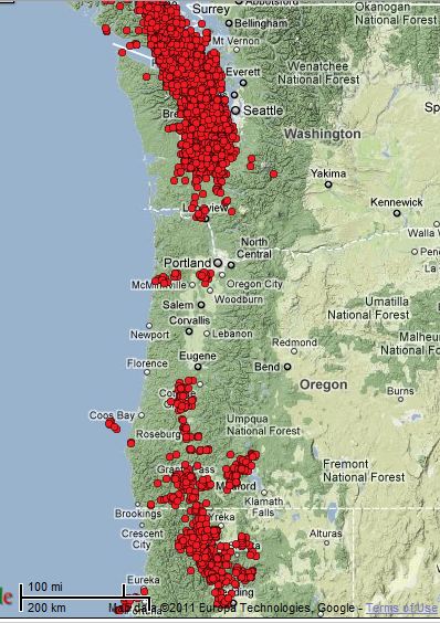
A quick overview of deep tremor activity in Cascadia. These quakes are less than magnitude 2, very deep, and are never felt above ground. What they
represent is the leading edge of the plate that is subducting, being pushed down into the mantle and melting away. Episodic tremor and slips occur in
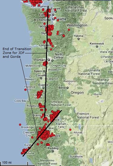
numerous locations around the world. The Cascadia Subduction Zone has two primary areas with ETS, at it's northern end, and southern end. There are
also ETS's in the mid section, but these are smaller events and not well studied. The first pic shows the most recent ETS's in the CSZ. The second
pic shows where the two plates, the JDF and Gorda, end. The Gorda is being pushed clockwise between three plates, the JDF, Pacific and North American.
That is why it's at an angle to JDF.
Originally posted by westcoast
Excellent!
Thanks for the info. I have noticed links between the deep tremors and quakes for awhile now and have suggested as such in my deep tremor threads (see link in sig), but I think that this is the best correllation.
Great job in narrowing down the tremor times/location vs the quake.
Westcoast, I just noticed that the time used for the tremor page is UTC. Damn, that means the tremor times are different than I intially posted. I gots to go back and redo timing. I wish they wouldnt do that UTC stuff when theyre only in one time zone. Buggers.
reply to post by zworld
I just want to stress that these are called deep tremors vs earthquakes. I have to constantly stop myself from calling them that, because then when people see all the circles on the map, they think that there are massive quakes going on.
These are a slow release of energy, resulting in tremors vs a quick release which causes quakes.
Each one of those dots represents a tremor, not a quake.
Now....you start doing some different searches/maps on that website and you see thousands and thousands of tremors in the past year. You begin to see a scary image appear. We have pretty much a constant humming going on under our feet. This is why I associate the humming I often hear with it....the extremely low hz just makes sense to me. But that is another story. )
ETA: Zworld, that gets me ALL the time. I still don't have the differences memorized. You would think, for a study based in PST that the time would indicate as such!!!
edit on 6-2-2012 by westcoast because: (no reason given)
Originally posted by westcoast
ETA: Zworld, that gets me ALL the time. I still don't have the differences memorized. You would think, for a study based in PST that the time would indicate as such!!!
So the actual times for the mid swarm place all of them before the main EQ at 8:05 PM on the 4th. Converting UTC/GMT to PST the first tremor between the onshore swarm and the big quake hit at 11:07 PM the night before the quake, and the rest of the swarm between noon and 1 PM, seven plus hours before the main quake. So the series of tremors began onshore with one occurring offshore, then silence onshore, a series offshore and then the big one.
Haven't had time to compare with any other onshore/offshore tremor series.
---------------------------------------
Originally posted by qmantoo
The time is UTC because you have to have a standard somewhere to compare with other events in other places in other time zones.
To show this in another way but not sure if the area covered may be too small/large to show any buildup.
Interesting graph Q. I guess these tremors are a little bigger than I envisaged. Up to 3.5.
I think the amount of energy released varies with each swarm but approaches M7 in the longer ones like the northern section of the CSZ has.
Excellent thread...people must wake up and prepare..this is not fearmongering..the earth is really p**s*d off at the moment..How is Vanuatu still
afloat..
Take care
Take care
The following diagram shows where the subducting parts of the tectonics occur in the Philippines. It is interesting that the earlier quakes were mid
way between the eastern subduction zone and the main quake. These weren't tremors, but Im beginning to see a pattern.
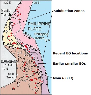
ON EDIT: Smaller EQs were a bit more north than my line points to. See below.
And thanks to berkeleygal (plus pic above) these EQs off central Oregon follow the pattern of smaller quakes mid distance to the forearc preceding a bigger quake. Hmmmm?
ON EDIT: Smaller EQs were a bit more north than my line points to. See below.
And thanks to berkeleygal (plus pic above) these EQs off central Oregon follow the pattern of smaller quakes mid distance to the forearc preceding a bigger quake. Hmmmm?
edit on 6-2-2012 by zworld because: (no reason given)
this is really interesting, I will keep an eye on this thread.
Originally posted by zworld
Does the lack of deep tremors in the middle of this zone indicate energy storage?
To clarify, does this image make you think that if a big quake were to hit soon, that it would be centered around Portland? I still haven't strapped my house to the foundation! I suppose I better get on that...
Originally posted by UdonNiedtuno
Does the lack of deep tremors in the middle of this zone indicate energy storage?
To clarify, does this image make you think that if a big quake were to hit soon, that it would be centered around Portland? I still haven't strapped my house to the foundation! I suppose I better get on that...
Good question. I should add that that particular capture was done to highlight that fact. It was an exceptionally quiet time in the mid section. Historically there are clusters and tremors that occur in that area. Not as much as the ends of the CSZ though.
Westcoast and others might have a better understanding of this, but it may be because of the triple junctions at play. At the north end you have the Queen Charlotte Triple Junction, which is actually two triple junctions due to a small bit of a soon to be extinct plate called Explorer getting over run. And the south end has the Mendocino Triple Junction, the real wildcard in the CSZ, as it tends to have even greater pressures exerted upon it from it's collision with the San Andreas/Pacific plate pushing it into the JDF. (on edit; I should say pushing the Gorda plate into the JDF as it subducts under the North American plate. All of this activity and pressure build up is however centered at the MTJ)
But strapping a house is a good idea, as the mid section will experience the full force of the big one since it is defined as a full rupture from north Vancouver Island to Cape Mendocino. The worst areas affected and suffering the most damage will be defined by geologic conditions under particular areas.
edit on 6-2-2012 by zworld because: (no reason given)
reply to post by zworld
Thanks for the reply. Thankfully my house is in an area of PDX that according to the earthquake danger maps shouldn't get shook up too bad (relatively speaking of course). The maps show the worst shaking will occur near downtown and along the Willamette, I hope my wife isn't at work when it happens. And as long as I'm hoping, I hope I am dead and gone and the world has better forecasting abilities before this one lets loose
Thanks for the reply. Thankfully my house is in an area of PDX that according to the earthquake danger maps shouldn't get shook up too bad (relatively speaking of course). The maps show the worst shaking will occur near downtown and along the Willamette, I hope my wife isn't at work when it happens. And as long as I'm hoping, I hope I am dead and gone and the world has better forecasting abilities before this one lets loose
Id strap that baby down man.....the next could well reach a mag 9 quake.
The vancouver island proper then, is going under the larger plate to the east?
Or will it ride up and over top of it the next biggy?
I certainly cannot imagine it sinking entirely into the sea......
(i live in Nanaimo by the way....)just north of the last batch,(Dint feel a thing)
The whole of cascadia may be broken up pretty badly in a 9 or so.....
I am thinking volcanic eruptions may also occur.....
St helens, three sisters,maybe even Mt Baker or other old volcanos could spew lava again.....
It is not so well understood just how many volcanos we do have here or the likelihood of setting one off.....
There are hot springs on the west coast of the island.....
new topics
-
WF Killer Patents & Secret Science Vol. 1 | Free Energy & Anti-Gravity Cover-Ups
General Conspiracies: 1 hours ago -
Hurt my hip; should I go see a Doctor
General Chit Chat: 2 hours ago -
Israel attacking Iran again.
Middle East Issues: 3 hours ago -
Michigan school district cancels lesson on gender identity and pronouns after backlash
Education and Media: 3 hours ago -
When an Angel gets his or her wings
Religion, Faith, And Theology: 4 hours ago -
Comparing the theology of Paul and Hebrews
Religion, Faith, And Theology: 5 hours ago -
Pentagon acknowledges secret UFO project, the Kona Blue program | Vargas Reports
Aliens and UFOs: 6 hours ago -
Boston Dynamics say Farewell to Atlas
Science & Technology: 6 hours ago -
I hate dreaming
Rant: 7 hours ago -
Man sets himself on fire outside Donald Trump trial
Mainstream News: 8 hours ago
top topics
-
The Democrats Take Control the House - Look what happened while you were sleeping
US Political Madness: 9 hours ago, 18 flags -
In an Historic First, In N Out Burger Permanently Closes a Location
Mainstream News: 11 hours ago, 16 flags -
A man of the people
Medical Issues & Conspiracies: 17 hours ago, 11 flags -
Biden says little kids flip him the bird all the time.
Politicians & People: 9 hours ago, 9 flags -
Man sets himself on fire outside Donald Trump trial
Mainstream News: 8 hours ago, 8 flags -
Michigan school district cancels lesson on gender identity and pronouns after backlash
Education and Media: 3 hours ago, 6 flags -
Pentagon acknowledges secret UFO project, the Kona Blue program | Vargas Reports
Aliens and UFOs: 6 hours ago, 6 flags -
Israel attacking Iran again.
Middle East Issues: 3 hours ago, 5 flags -
Boston Dynamics say Farewell to Atlas
Science & Technology: 6 hours ago, 4 flags -
WF Killer Patents & Secret Science Vol. 1 | Free Energy & Anti-Gravity Cover-Ups
General Conspiracies: 1 hours ago, 4 flags
active topics
-
Man sets himself on fire outside Donald Trump trial
Mainstream News • 39 • : TheMisguidedAngel -
When an Angel gets his or her wings
Religion, Faith, And Theology • 5 • : randomuser2034 -
Anyone one else having Youtube problems
Computer Help • 11 • : charlyv -
The Democrats Take Control the House - Look what happened while you were sleeping
US Political Madness • 68 • : Mahogani -
Candidate TRUMP Now Has Crazy Judge JUAN MERCHAN After Him - The Stormy Daniels Hush-Money Case.
Political Conspiracies • 404 • : Zanti Misfit -
In an Historic First, In N Out Burger Permanently Closes a Location
Mainstream News • 10 • : Degradation33 -
SC Jack Smith is Using Subterfuge Tricks with Donald Trumps Upcoming Documents Trial.
Dissecting Disinformation • 100 • : WeMustCare -
Israel attacking Iran again.
Middle East Issues • 23 • : KrustyKrab -
So I saw about 30 UFOs in formation last night.
Aliens and UFOs • 37 • : charlyv -
Hurt my hip; should I go see a Doctor
General Chit Chat • 11 • : TheLieWeLive