It looks like you're using an Ad Blocker.
Please white-list or disable AboveTopSecret.com in your ad-blocking tool.
Thank you.
Some features of ATS will be disabled while you continue to use an ad-blocker.

West Coast USA: Pay Attention, Cascadia May Be Ready to Rupture
page: 9share:
Originally posted by TrueAmerican
reply to post by PuterMan
Oh for Pete's sakes, stop being so grumpy and let me play. I might just surprise the crap out of you in the next months.
Also in regards to:
reply to post by PuterMan
When I said frequency was increasing, I didn't mean long term averages, at all. I know you are the long term average king, but I am talking about when in a short period of time they increase in frequency. Like two quakes on different parts of the fault within hours of each other. That's what I meant, sweetheart.edit on Sat Feb 4th 2012 by TrueAmerican because: (no reason given)
Maybe people should watch the local papers to for lost pets, they say more will have run away with imminent quake. we have 4 kitties listed right now...usualy have 0-1 so above typical but no dogs..Crescent City ca/or border
Originally posted by steve95988
I live in norcal and think its about over due for a large earthquake along the westcoast..
In-fact it may be a blessing in disguise,, shake some of these idiots up a lil!!
You do know that if Cascadia goes, there will be a big tsunami probably wiping out lots of cities right?
Tens of thousands of dead right?
First time I ever posted in a Earthquake Thread because I know nothing to add.
I have a theory, probably nothing.
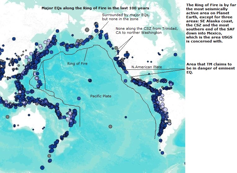
But if you look at the Ring of Fire like a Box, The only corner missing a 9 in the last few years is Can, US
South Pacific West = Indonesia
North Pacific West = Japan
South Pacific East = Chile
North Pacific East = .......
I have a theory, probably nothing.
But if you look at the Ring of Fire like a Box, The only corner missing a 9 in the last few years is Can, US
South Pacific West = Indonesia
North Pacific West = Japan
South Pacific East = Chile
North Pacific East = .......
Ive posted this in other threads but it bears repeating.
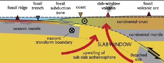
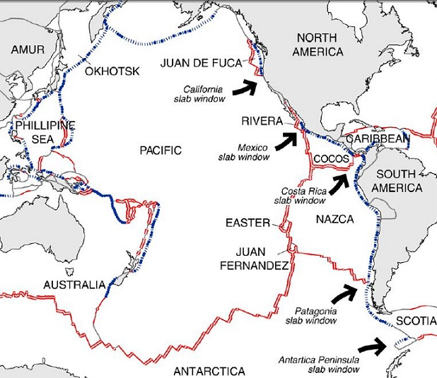
In Humboldt Co. we have something very rare, and area with no tectonic plate at all. Not the Gorda, not the Pcaific, not the North American. Three to choose from and still there's a place with none. Kinda like an open wound bleeding molten rock. They are called slab gaps, slab windows, and slabless windows. All mean the same thing. The under riding plate that is being subducted has a stretch where it literally tears apart and leaves an opening that is filled by magma from below. These areas that are closest to the mantle often experience volcanic activity. And the one in NW California is the closest to the surface of any in North America.
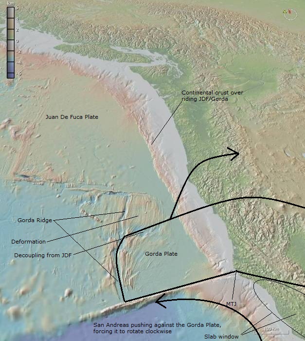
And this gives a good idea of the level of deformation being caused by the interactions between Gorda and the Pacific and N American plates and the slabless window. Of special note, near the drop off area on the south edge of the Gorda plate, an undersea volcano erupted a couple of years ago.
And this is the location of the slabless window. (circled area)
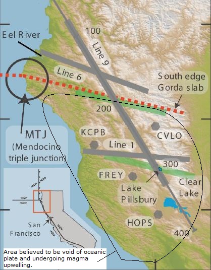
And this shows how little big quake activity has occurred in the MTJ area.
In Humboldt Co. we have something very rare, and area with no tectonic plate at all. Not the Gorda, not the Pcaific, not the North American. Three to choose from and still there's a place with none. Kinda like an open wound bleeding molten rock. They are called slab gaps, slab windows, and slabless windows. All mean the same thing. The under riding plate that is being subducted has a stretch where it literally tears apart and leaves an opening that is filled by magma from below. These areas that are closest to the mantle often experience volcanic activity. And the one in NW California is the closest to the surface of any in North America.
And this gives a good idea of the level of deformation being caused by the interactions between Gorda and the Pacific and N American plates and the slabless window. Of special note, near the drop off area on the south edge of the Gorda plate, an undersea volcano erupted a couple of years ago.
And this is the location of the slabless window. (circled area)
And this shows how little big quake activity has occurred in the MTJ area.
Originally posted by Tw0Sides
I have a theory, probably nothing.
Or everything. See last pic in my post above. I did a report on the need to understand the forces at work behind your theory. And that particular theory is fueling alot of debate in USGS and other geology agencies. Basically, it's the reason that trying to estimate a constant incoming stress level on locked points in the CSZ, or the other areas void of a major quake, wont work. Way too many variables at play exerting and/or releasing energy.
The bottom line is that tectonic energy has been pushed into the southern CSZ, and it is coming from all directions, and no major quake so far has occurred. Something gives eventually.
Originally posted by TrueAmerican
A suite of 15 Episodic Tremor and Slip events imaged between 1997 and 2008 along the northern Cascadia subduction zone suggests future coseismic rupture will extend to 25 km depth, or ~60 km inland of the Pacific coast, rather than stopping offshore at 15 km depth. The ETS-derived coupling profile accurately predicts GPS-measured interseismic deformation of the overlying North American plate, as measured by ~50 continuous GPS stations across western Washington State.
When extrapolated over the 550-year average recurrence interval of Cascadia megathrust events, the coupling model also replicates the pattern and amplitude of coseismic coastal subsidence inferred from previous megathrust earthquakes here. For only the Washington State segment of the Cascadia margin, this translates into an Mw=8.9 earthquake, with significant moment release close to metropolitan regions.
www.geodesy.cwu.edu...
Visit link to see some charts.
In other words, there are good reasons to believe a future big quake could occur either very close to shore, or under land itself. The good news is that the further inland it occurs, the deeper that it is likely to be, because of the dip angle of the subducting slab.
The worst case scenario in my opinion is a very big quake, literally right offshore, making it quite shallow, and allowing only minutes or seconds reaction time to a very big tsunami.
TrueAmerican, after reading over the article I think what they are saying is much worse than your interpretation. And much worse than both your worst case scenerio and mine as well. Reading the below, I believe they're saying that the quake will still start offshore at a depth of 10 km, but not stop at the 25 km depth, which would put it just onshore. They're saying it will keep going to a depth between 25 and 70 km, putting it way onshore. In other words, the rupture in north Cascadia will not only have the potential of tearing over a long distance north and south wise, but a fairly long distance west to east as well.
Im blown away. Folks, we are talking a quake many times a 9 possibly from north Vancouver Island (or beyond if Explorer plate joins the fracas) to south of Cape Mendocino and extending onshore into the Vancouver/Seattle area, Willamette Valley and Sacremento Valley.
Throw in a volcano and I am out of here.
The transition starts offshore near 10 km depth, with 100% "locked"-coupling dropping smoothly to half by 25 km depth. However, unlike previous models, the lower limit of the effective transition zone here is constrained by repeated ETS events to be near 25 km depth. To fit the interseismic GPS data while matching the estimate of moment release by ETS, plate coupling must drop abruptly from 50% up-dip of the 25 km depth to less than 15% within the ETS zone, before trending smoothly to 0 (i.e., "freely sliding") by 70 km depth.
TrueAmerican,
I had a thought recently come up and wanted to bring it your way in hopes you can expand on it more...
Have you ever heard of the growing earth theory vs plate tectonic /subduction theory? Here's a 10 minute video
explaining :
Well if you apply this concept of the earth growing and moving, then what he says at the end about there being no subduction zones and the way we think of geology is wrong. Just thinking outside of the box as to whats causing eaarthquakes and if theres another possible explanation to whats going on?!
reply to post by zworld
z, I would not regret that decision to leave if I were you. Even if you go to your grave, and not a single thing happens, just think how you will feel if it does. Sad, but ALIVE! And maybe not that badly affected if you stay far enough away from that zone. Nice thing is, at least you're not over here in the east where the seismic waves propagate with much less attenuation. West coast rheology is such that it does work in your favor- so you won't have to go nearly as far to get away from the most serious danger. In a pinch, maybe 40 miles away from the coast. I'd prefer 100+, but hey, can't have it all, now can we.
As to the volcano, yeah there's a lot that could happen. Long Valley erupting of course would be a possibility. And that's a very bad one. I have undertaken a massive amount of research on the big Chile quake of 1960 in the last few days, and I swear, the more I learn about it, the more scared I get for all of you out there on the west coast. To recap some not often talked about things that may be of particular concern to you:
1) There have been several studies done to try and determine WHAT it was that preceded the main event for about 15 minutes. A couple of trained seismologists present for all these events said they witnessed cars rolling back and forth in parking lots. All indications are this was some kind of aseismic slow slip. Sound familiar?
Yep.
2) A volcano appears to have been directly triggered and erupted following the quake.
3) There were MANY foreshocks, some HUGE (7+ and one 8.1!) before the main event. Now imagine in the span of a mere 33 hours, going through this. There you sit and a 7+ hits, sending mad people out into the streets, and pre-damaging buildings- and rescue teams on their way. And then several more of those hit, and then a massive 8.1 hits. Jesus! And so you thought that was it, and it would all be diminishing aftershocks after that...Right...Nuh uh...
The earth was just warming up. The massive 9.5 then struck, completing total destruction of whatever was still left. And if there WAS anything left, the massive aftershocks to follow had no problem with those. And on top of that, multiple tsunamis from each quake! :shk: And check out some of the ground displacements- unreal!
I mean no. Just no. Why live under this kind of threat when you have a choice?
That massive quake sequence proceeded rather quickly from background seismicity levels.
NOW DO YOU HATERS (NOT YOU Z) SEE WHY STAYING ON TOP OF THE FREQUENCY OF QUAKES IN CASCADIA IS IMPORTANT??? I see that many quakes in such a short period of time, and you're damn straight I am going to report it, if it takes me 1000 threads. So there.
----------------------------------------------------
And Alche, yes I have heard plenty about expanding earth theory, but it was effectively quashed dead by extremely tight, high tech measurements from several methods, including GPS and satellites. The variance in earth's diameter is so small (less than a millimeter per year or something), that worrying about it just makes no sense. I'd get off that train if I were you.
edit on Thu Feb 9th 2012 by TrueAmerican because: (no reason
given)
Hey TA...I could use your help.
I just started a new thread about a wierd experience tonight:
THREAD
I've got confirmation from several other people in my area spread out over 30 miles. It sounded/felt like a large quake building then suddenly cut out.
Mr. Vidale at PNSN located a small quake showing on a few boreholes nearby in Canada, but not big enough to have been felt/heard this far away.
I am stumped. Can you take a closer look?
It was experienced in Anacortes, Sedro woolley and Mount vernon. Just after ten pm PST....if it was a sound wave, it could have originated a several minutes before that.
Everyone should keep watch on the site(s) showing these quakes worldwide. It gives a big picture so they can visualize how much and what direction the
plate is attempting to move. Usually it's to the equator. Sunspots change things in earth's energy grid (ley lines) and so on. I've never seen any
site analyze all the data, but whoever runs haarp does , and they control those quakes setting some off here and there so that we don't get 'em here
on US.
The Osaka quake was planned more than 2 weeks ahead of time. I'ts not just my opinion either, look it up. Clouds changed overhead like they do before these manmade quakes.
The Osaka quake was planned more than 2 weeks ahead of time. I'ts not just my opinion either, look it up. Clouds changed overhead like they do before these manmade quakes.
reply to post by westcoast
Yeah sure. Find a link to the quake he found and post it please.
Also:
1) please read my post above yours.
and
2) The ETS in your area could possibly be the cause.
And I'll throw in :
3) I told you in my opinion already that the Cascadia fault was not happy at the moment, due to some things I am seeing with the Ferrari, which, by the way, turns out is not the complete car. I got a stripped down Ferrari. Only the pros can have the racetrack version, if you get my drift. But still, I have way more juice than before. And I do not like one bit what I am seeing. The question is, is it normal for the area. I also said I need way more time in there, and I do. I wish I had been monitoring while that happened to you.
reply to post by TrueAmerican
It shows best here: B011 EHZ
found HERE
at 5:58 UTC
Thanks..
It shows best here: B011 EHZ
found HERE
at 5:58 UTC
Thanks..
edit on 9-2-2012 by westcoast because: (no reason given)
reply to post by westcoast
Best I can tell through spectrum, it appears to be either a very small seismic event or even an ice quake. Heh, and Lord knows we have experience with those now... But you sure those UTC times match up to the exact time you heard this? Cause right after that there appears to be some kind of long, 9 Hz or so, narrow band hum of some kind coming from that station- or from something.
Best I can tell through spectrum, it appears to be either a very small seismic event or even an ice quake. Heh, and Lord knows we have experience with those now... But you sure those UTC times match up to the exact time you heard this? Cause right after that there appears to be some kind of long, 9 Hz or so, narrow band hum of some kind coming from that station- or from something.
reply to post by zworld
Hi zworld, thanks for all of the information and associated articles. The CSZ is absolutely a catastrophe in the making.
I interpret this study a little differently, although the awful conclusions are still the same.
To me, the author is saying that instead of anticipating "only" a rupture of the "100% locked zone", which is the area from the trench/toe/accretionary wedge, then inland to a depth of 10-15 km (still offshore in most of the northern CSZ); but now, because of ETS data, they anticipate the ruptured fault area to include the above plus the area in the "transition zone" to a depth of 25km, which, at the surface, is approximately 60 km inland.
So, a much larger fault surface area than previously thought possible, and closer to Seattle-Tacoma.
More frightening to me, is the 9 meters (30 feet!) of accumulated stress in the area 60 km inland and seaward.
Source of external quotes
That is a huge amount of lateral movement, not to mention the uplift and subsidence. And joy, this study only covers the northern end of the zone...
Hi zworld, thanks for all of the information and associated articles. The CSZ is absolutely a catastrophe in the making.
I interpret this study a little differently, although the awful conclusions are still the same.
To me, the author is saying that instead of anticipating "only" a rupture of the "100% locked zone", which is the area from the trench/toe/accretionary wedge, then inland to a depth of 10-15 km (still offshore in most of the northern CSZ); but now, because of ETS data, they anticipate the ruptured fault area to include the above plus the area in the "transition zone" to a depth of 25km, which, at the surface, is approximately 60 km inland.
So, a much larger fault surface area than previously thought possible, and closer to Seattle-Tacoma.
A suite of 15 Episodic Tremor and Slip events imaged between 1997 and 2008 along the northern Cascadia subduction zone suggests future coseismic rupture will extend to 25 km depth, or ~60 km inland of the Pacific coast, rather than stopping offshore at 15 km depth.
More frightening to me, is the 9 meters (30 feet!) of accumulated stress in the area 60 km inland and seaward.
The most important aspect for northern Cascadia is that stronger coupling between 15 and 25 km implies greater coseismic slip near major population centers, and provides an estimate of future coseismic slip along this region. 50% coupling suggests 9 meters of slip should be expected directly up-dip of 25 km. This lies well inland of the coast, directly west of the greater Seattle-Tacoma metropolitan basin.
Source of external quotes
That is a huge amount of lateral movement, not to mention the uplift and subsidence. And joy, this study only covers the northern end of the zone...
edit on 2/9/2012 by Olivine because: add source and fix spelling
edit on 2/9/2012 by Olivine because: (no reason
given)
Wish we were living off planet more and more everyday, lol. We could finally have a bit more control over these kinds of things that way and then the
animals can live freely and less pollution worries.
But we need several thousand years more for that. Purely science fiction.
But we need several thousand years more for that. Purely science fiction.
edit on 9-2-2012 by jonnywhite because: (no reason given)
I escaped northern cali about 14 years ago for many reason, quakes being the lesser at the time. I have been watching things over there since then and
have seen many things that I will no longer discuss. I just wanted to let those in EQ territory know of a trick I learned of long ago. You will be
able to see if there was a quake even if you did not feel it. It may not work real well in a home that vibrates by just walking through it. But you
should be able to work around that for the most part.
Find a quart jar, clear. fill it with water at least 3/4 full and set it someplace you frequent. So you can look at it at a glance should you think you feel something. If you are worried about it spilling, put a lid on it. It should not affect its motion. Heck put them in several rooms if you do not just sit in one most the time.
I learned of many quakes this way. A solid redwood home didn't shake with simple walking through it like the old Victorians.
Be Safe Folks. The Good Lord ripped my life to shreds to make me leave that area in 98 because I did not listen to what I was told in 87. Peace be with you all.
~AM~
Let me just add, just because the EQ sites do not show an EQ does not mean you did not have one.
edit on 9-2-2012 by amethystmoon because: (no
reason given)
Originally posted by Olivine
reply to post by zworld
Hi zworld, thanks for all of the information and associated articles. The CSZ is absolutely a catastrophe in the making.
I interpret this study a little differently, although the awful conclusions are still the same.
To me, the author is saying that instead of anticipating "only" a rupture of the "100% locked zone", which is the area from the trench/toe/accretionary wedge, then inland to a depth of 10-15 km (still offshore in most of the northern CSZ); but now, because of ETS data, they anticipate the ruptured fault area to include the above plus the area in the "transition zone" to a depth of 25km, which, at the surface, is approximately 60 km inland.
So, a much larger fault surface area than previously thought possible, and closer to Seattle-Tacoma.
Thanks Olivine. And I think your right. The big one will stretch all the way to where the ETSs occur. Is that right. Still pretty much the same conclusion which is not good. And I think I am going to take TAs advice and take a lengthy trip to the four corners area to help with spring planting on the rez.
-------------------------
WC, that has happened to me so many times I dont even check now. I have been absolutely sure we just had a small quake, yet nothing has happened anywhere within range. Damn strange that. I figure its military stuff off the coast as they use this area for testing of who knows what. And they tell USGS and other agencies to ignore it .Either that or I am picking up something totally weird.
Originally posted by TrueAmerican
reply to post by westcoast
Best I can tell through spectrum, it appears to be either a very small seismic event or even an ice quake. Heh, and Lord knows we have experience with those now... But you sure those UTC times match up to the exact time you heard this? Cause right after that there appears to be some kind of long, 9 Hz or so, narrow band hum of some kind coming from that station- or from something.
Actually, the time of that quake is too early. Everyone I have talked to says the same thing, that it was right after ten. I know it was, because I was watching Face-off. I think it was 10:05-10:10. It happened twice. First time was probably well over a minute, second time less than 30 sec.
I would be very curious about the 9hz you are seeing. It seems to have been more of a soundwave of some sort. I now have someone in Big Lake too that was woken up by it. This gives me a triangle of roughly 30+ miles so far from the ocean up to the mountains.
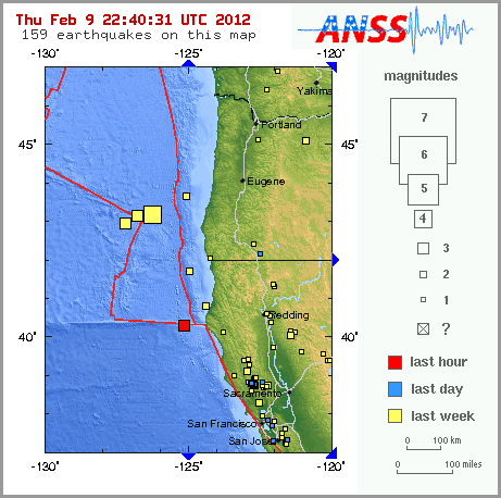
earthquake.usgs.gov...
Magnitude
3.0
Date-Time
Thursday, February 09, 2012 at 21:58:41 UTC
Thursday, February 09, 2012 at 01:58:41 PM at epicenter
Time of Earthquake in other Time Zones
Location
40.334°N, 125.195°W
Depth
0.6 km (~0.4 mile) (poorly constrained)
Region
OFFSHORE NORTHERN CALIFORNIA
Distances
77 km (48 miles) W (271°) from Petrolia, CA
83 km (52 miles) WSW (251°) from Ferndale, CA
93 km (58 miles) WSW (253°) from Fortuna, CA
101 km (63 miles) WSW (240°) from Eureka, CA
372 km (231 miles) NW (321°) from San Francisco City Hall, CA
Location Uncertainty
horizontal +/- 3.2 km (2.0 miles); depth +/- 8 km (5.0 miles)
Parameters
Nph= 32, Dmin=76 km, Rmss=0.25 sec, Gp=263°,
M-type=duration magnitude (Md), Version=1
Source
California Integrated Seismic Net:
USGS Caltech CGS UCB UCSD UNR
Event ID
nc71727275
reply to post by TrueAmerican
I keep hearing about these earthquakes around the Portland area but I'm yet to feel one. They're pretty common though, personally I don't think it's something to worry about.
I keep hearing about these earthquakes around the Portland area but I'm yet to feel one. They're pretty common though, personally I don't think it's something to worry about.
new topics
-
Las Vegas UFO Spotting Teen Traumatized by Demon Creature in Backyard
Aliens and UFOs: 1 hours ago -
2024 Pigeon Forge Rod Run - On the Strip (Video made for you)
Automotive Discussion: 2 hours ago -
Gaza Terrorists Attack US Humanitarian Pier During Construction
Middle East Issues: 2 hours ago -
The functionality of boldening and italics is clunky and no post char limit warning?
ATS Freshman's Forum: 3 hours ago -
Meadows, Giuliani Among 11 Indicted in Arizona in Latest 2020 Election Subversion Case
Mainstream News: 4 hours ago -
Massachusetts Drag Queen Leads Young Kids in Free Palestine Chant
Social Issues and Civil Unrest: 4 hours ago -
Weinstein's conviction overturned
Mainstream News: 5 hours ago -
Supreme Court Oral Arguments 4.25.2024 - Are PRESIDENTS IMMUNE From Later Being Prosecuted.
Above Politics: 7 hours ago -
Krystalnacht on today's most elite Universities?
Social Issues and Civil Unrest: 7 hours ago -
Chris Christie Wishes Death Upon Trump and Ramaswamy
Politicians & People: 7 hours ago
top topics
-
Krystalnacht on today's most elite Universities?
Social Issues and Civil Unrest: 7 hours ago, 9 flags -
Weinstein's conviction overturned
Mainstream News: 5 hours ago, 6 flags -
University of Texas Instantly Shuts Down Anti Israel Protests
Education and Media: 10 hours ago, 6 flags -
Supreme Court Oral Arguments 4.25.2024 - Are PRESIDENTS IMMUNE From Later Being Prosecuted.
Above Politics: 7 hours ago, 5 flags -
Massachusetts Drag Queen Leads Young Kids in Free Palestine Chant
Social Issues and Civil Unrest: 4 hours ago, 4 flags -
Meadows, Giuliani Among 11 Indicted in Arizona in Latest 2020 Election Subversion Case
Mainstream News: 4 hours ago, 4 flags -
Chris Christie Wishes Death Upon Trump and Ramaswamy
Politicians & People: 7 hours ago, 2 flags -
Any one suspicious of fever promotions events, major investor Goldman Sachs card only.
The Gray Area: 12 hours ago, 2 flags -
Gaza Terrorists Attack US Humanitarian Pier During Construction
Middle East Issues: 2 hours ago, 2 flags -
2024 Pigeon Forge Rod Run - On the Strip (Video made for you)
Automotive Discussion: 2 hours ago, 1 flags
active topics
-
Supreme Court Oral Arguments 4.25.2024 - Are PRESIDENTS IMMUNE From Later Being Prosecuted.
Above Politics • 65 • : Annee -
Cats Used as Live Bait to Train Ferocious Pitbulls in Illegal NYC Dogfighting
Social Issues and Civil Unrest • 22 • : NoviceStoic4 -
Sunak spinning the sickness figures
Other Current Events • 22 • : angelchemuel -
Massachusetts Drag Queen Leads Young Kids in Free Palestine Chant
Social Issues and Civil Unrest • 10 • : Cre8chaos79 -
Nearly 70% Of Americans Want Talks To End War In Ukraine
Political Issues • 93 • : Xtrozero -
University of Texas Instantly Shuts Down Anti Israel Protests
Education and Media • 194 • : Irishhaf -
Fossils in Greece Suggest Human Ancestors Evolved in Europe, Not Africa
Origins and Creationism • 88 • : Xtrozero -
Gaza Terrorists Attack US Humanitarian Pier During Construction
Middle East Issues • 20 • : Justsomeboreddude3 -
Thousands Of Young Ukrainian Men Trying To Flee The Country To Avoid Conscription And The War
Other Current Events • 141 • : Consvoli -
Terrifying Encounters With The Black Eyed Kids
Paranormal Studies • 77 • : burritocat