It looks like you're using an Ad Blocker.
Please white-list or disable AboveTopSecret.com in your ad-blocking tool.
Thank you.
Some features of ATS will be disabled while you continue to use an ad-blocker.

West Coast USA: Pay Attention, Cascadia May Be Ready to Rupture
page: 12share:
So, the northern end of the subduction zone shows some wiggling.
Mag 4.2 offshore Vancouver Island, Canada
Mag 4.2 offshore Vancouver Island, Canada
edit on 2/14/2012 by Olivine because: improve post
edit on 2/14/2012 by Olivine because: link
USGS is showing a new 4.2 off of Vancouver. I am having issues with linking it.
edit on 14-2-2012 by AuntB because: (no reason given)
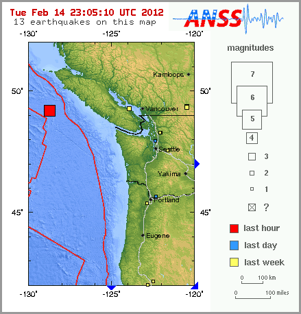
Magnitude
4.2
Date-Time
Tuesday, February 14, 2012 at 22:54:40 UTC
Tuesday, February 14, 2012 at 02:54:40 PM at epicenter
Time of Earthquake in other Time Zones
Location
49.214°N, 128.751°W
Depth
10 km (6.2 miles)
Region
VANCOUVER ISLAND, CANADA REGION
Distances
191 km (118 miles) SSW of Port Hardy, British Columbia, Canada
235 km (146 miles) W of Ucluelet, British Columbia, Canada
268 km (166 miles) WSW of Campbell River, British Columbia, Canada
405 km (251 miles) WNW of VICTORIA, British Columbia, Canada
Location Uncertainty
horizontal +/- 25 km (15.5 miles); depth +/- 2.7 km (1.7 miles)
Parameters
NST= 33, Nph= 33, Dmin=268.3 km, Rmss=0.65 sec, Gp=212°,
M-type=body wave magnitude (Mb), Version=9
Source
Magnitude: USGS NEIC (WDCS-D)
Location: USGS NEIC (WDCS-D)
Event ID
usb00080ej
earthquake.usgs.gov...
Originally posted by Olivine
So, the northern end of the subduction zone shows some wiggling.
Mag 4.2 offshore Vancouver Island, Canada
edit on 2/14/2012 by Olivine because: improve post
edit on 2/14/2012 by Olivine because: link
That will probably just get rung up as an aftershock of the recent 5.7 near there, cause it looks like that's all it is.
At least, let us all hope so. I wonder if they chose the name Cascadia because when it finally goes, it's like a cascading domino effect played with fault lines, 7+ quakes and huge tsunamis, instead of dominoes? Nah.
I am guessing that if this thing is serious about letting loose, expect a bigger quake in the next days in the purple path somewhere. If that quake is above 6.5 or so, and in the purple pathway, that is going to be real bad news. If it's over 7, I'd seriously LEAVE. IMMEDIATELY.
And the problem is, once those kind of large stress redistributions start occurring with bigger quakes in a loaded zone, then one need look no further than Chile 1960 for the results of what can happen.
Right now I am hoping that 5.6 on the unknown fault extension doesn't cause some problems directly north of there.
reply to post by westcoast
Why don't some of you folks take a look at the two magnetometers referenced in my signature?
You might find some of your spectrogram excitement there. Just a thought.
MCW.UW..EHZ.2012.045 by the way. I don't believe any other than one or two (actually 3 at most) on that spectrogram are seismic signatures. Of course I may be wrong.
I have downloaded the whole day from that seismo. I can find one quake at ~22:55 and basically the rest is either rubbish or 'military aircraft' type pops that are not seismic in origin.
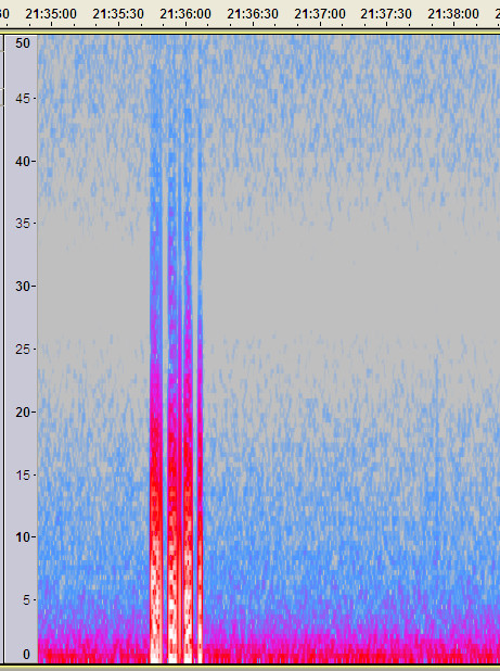
As an example.
Oh and a telesism at ~08:32
Why don't some of you folks take a look at the two magnetometers referenced in my signature?
You might find some of your spectrogram excitement there. Just a thought.
Actually, by the looks of THIS one, I would say they haven't stopped
MCW.UW..EHZ.2012.045 by the way. I don't believe any other than one or two (actually 3 at most) on that spectrogram are seismic signatures. Of course I may be wrong.
edit on 14/2/2012 by PuterMan because: (no reason given)
I have downloaded the whole day from that seismo. I can find one quake at ~22:55 and basically the rest is either rubbish or 'military aircraft' type pops that are not seismic in origin.
As an example.
Oh and a telesism at ~08:32
edit on 14/2/2012 by PuterMan because: (no reason given)
Originally posted by PuterMan
Why don't some of you folks take a look at the two magnetometers referenced in my signature?
You might find some of your spectrogram excitement there. Just a thought.
So are you suggesting that seismographs are detecting temporal variations of the geomagnetic field, as opposed to slow-slip? You do realize what kind of insane amounts of gain they are applying to that instrument to derive those FFT spectros, right? And that special instrument is wholly different than a seismic instrument, right? Are you sure we're operating in the same ballpark here? Or is one baseball and the other football?
edit on
Tue Feb 14th 2012 by TrueAmerican because: (no reason given)
reply to post by TrueAmerican
I have shown many times that the magnetosphere affects seismographs - or the transmissions of the data. I have even matched them to the magnetograms and got an exact fit.
Since I do not know that parameters they are using and whether those are FFT of STFT or something else I cannot comment, but I will say that gain destroys the signal in my limited experience so I would be surprised if they were applying much.
I have to apply quite a bit of gain to hear the sound, but that makes the spectrograms very fuzzy.
The big spikes are NOT slip. You want the SAC file for the day?
So are you suggesting that seismographs are detecting temporal variations of the geomagnetic field
I have shown many times that the magnetosphere affects seismographs - or the transmissions of the data. I have even matched them to the magnetograms and got an exact fit.
Since I do not know that parameters they are using and whether those are FFT of STFT or something else I cannot comment, but I will say that gain destroys the signal in my limited experience so I would be surprised if they were applying much.
I have to apply quite a bit of gain to hear the sound, but that makes the spectrograms very fuzzy.
as opposed to slow-slip?
The big spikes are NOT slip. You want the SAC file for the day?
edit on 14/2/2012 by PuterMan because: (no reason given)
reply to post by PuterMan
FFT:
GAIN:
www.haarp.alaska.edu...
And whoa, I have not made any connection with those spikes and ETS. The other folks like wc are linking to spectrograms that are supposedly displaying ETS. And your post suggests that magnetic variation may be what they are seeing instead of ETS. At least that's the way I understood what you were saying? Is that not correct?
FFT:
Spectrograms are produced from the timeseries by computing the Power Spectral Density (PSD) of successive 102.4 second (1024 point) segments of data using the Fast Fourier Transform (FFT) technique. Each 24-hour continuous timeseries yields 844 individual PSD plots with 0.01 Hz resolution from 0 to 5.0 Hz. The spectrograms are visualized using a color/intensity map to produce a 2-D image from the data. The DISLIN Scientific Data Plotting library is used to generate the plots.
GAIN:
The magnetic flux density is enhanced by a factor of approximately 1,000 by the high-permeability metal core.
The sensor outputs are amplified by 40,000 and sampled at a 10 Hz rate with 16-bit resolution in a full scale of 10 Volts.
www.haarp.alaska.edu...
And whoa, I have not made any connection with those spikes and ETS. The other folks like wc are linking to spectrograms that are supposedly displaying ETS. And your post suggests that magnetic variation may be what they are seeing instead of ETS. At least that's the way I understood what you were saying? Is that not correct?
edit on Tue Feb 14th 2012 by TrueAmerican because: (no reason given)
Anyone have any advice on an earthquake preparedness kit that I can make or a link?
( I live on Northern Vancouver Island) Thanks.
( I live on Northern Vancouver Island) Thanks.
Originally posted by phoenixlights321
Anyone have any advice on an earthquake preparedness kit that I can make or a link?
( I live on Northern Vancouver Island) Thanks.
On Vancouver Island?
Heh, yeah. Instant survival should the Big One hit.
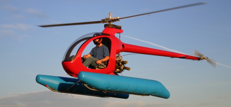
Mosquito XEL NO PILOTS LICENSE REQUIRED TO FLY THIS HELICOPTER IN USA**
When your preference in a Part 103 ultralight requires more of a standard fuselage and cockpit then the XEL will meet your needs. The integrated fuselage standard to all XE models forms a most pleasing and aerodynamic shell with all the required instrumentation and comforts a recreational pilot might want. The included safety floats provide an exemption to the standard 103 weight limit to keep this beautiful ship within the ultralight category. This helicopter can also be flown under FAA Part 103 ultralight rules and does not require aircraft registration or pilot license*. The Mosquito XEL is available ReadyBuilt©, as a full kit or can be purchased in sub groups. A deposit as low as $5,000 for the first sub-group or $10,000 for the entire kit will get you an immediate spot on the production line. Videos
rotorfx.com...
You too, can fly over the tsunami...
edit on Tue Feb 14th 2012 by TrueAmerican because: (no reason given)
reply to post by TrueAmerican
hahah thanks. I've always wanted a jetpack for these reasons. I'm about 220 feet above sea level so hopefully that helps out.
hahah thanks. I've always wanted a jetpack for these reasons. I'm about 220 feet above sea level so hopefully that helps out.
Another quake coming in on west coast...stay tuned
5.9 OFF OREGON
earthquake.usgs.gov...
Nope nothing to see here...
At what point does hoping it all goes away become wishful thinking?
UPGRADED TO 6.0
So the question is:
Is the fault serious about letting loose?
5.9 OFF OREGON
earthquake.usgs.gov...
Nope nothing to see here...
edit on Tue Feb 14th 2012 by TrueAmerican because: (no reason given)
At what point does hoping it all goes away become wishful thinking?
edit on Tue Feb 14th 2012 by TrueAmerican because: (no reason
given)
UPGRADED TO 6.0
edit on Tue Feb 14th 2012 by TrueAmerican because: (no reason given)
So the question is:
Is the fault serious about letting loose?
edit on Tue Feb 14th 2012 by TrueAmerican because: (no reason given)
reply to post by TrueAmerican
Ok TA, I've been following thread since page 1 & now with that 5.9 you're
starting to scare me. Nice work.
Ok TA, I've been following thread since page 1 & now with that 5.9 you're
starting to scare me. Nice work.
reply to post by TrueAmerican
Excuse my ignorance in these matters, but does it mean anything that it's the same depth as the Vancover event?
10km.
Excuse my ignorance in these matters, but does it mean anything that it's the same depth as the Vancover event?
10km.
ON EDIT: The below map has been corrected at PNSN to now show only one quake.
Holy fired chicken Batman. There were two EQs off oregon both 5.9. Yikes
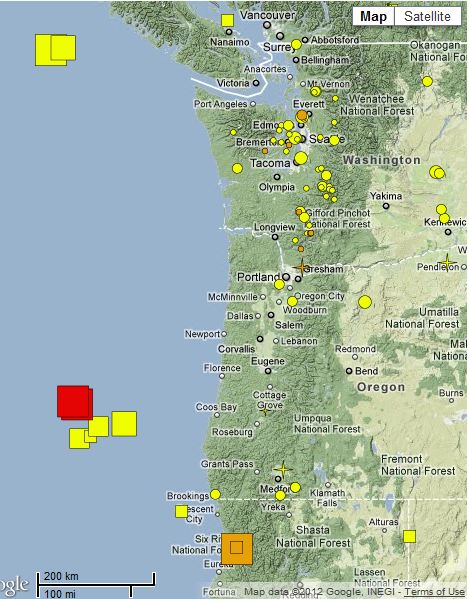
Holy fired chicken Batman. There were two EQs off oregon both 5.9. Yikes
edit on 14-2-2012 by zworld because: (no reason given)
OH F--- Just got in - Happy V-Day to all - not good, not good at all --= be safe
Source
Folks time to really think about a vacation inland!!!
Magnitude 6.0 - OFF THE COAST OF OREGON
2012 February 15 03:31:20 UTC
Versión en Español
DetailsMapsTsunami Earthquake Details
This event has been reviewed by a seismologist.
Magnitude 6.0
Date-Time Wednesday, February 15, 2012 at 03:31:20 UTC
Tuesday, February 14, 2012 at 07:31:20 PM at epicenter
Location 43.536°N, 127.381°W
Depth 10 km (6.2 miles)
Region OFF THE COAST OF OREGON
Distances 256 km (159 miles) W of Coos Bay, Oregon
293 km (182 miles) WSW of Newport, Oregon
302 km (187 miles) NW of Brookings, Oregon
380 km (236 miles) WSW of SALEM, Oregon
Location Uncertainty horizontal +/- 19.7 km (12.2 miles); depth +/- 6.2 km (3.9 miles)
Parameters NST=205, Nph=211, Dmin=282.8 km, Rmss=1.15 sec, Gp=180°,
M-type=regional moment magnitude (Mw), Version=6
Source Magnitude: USGS NEIC (WDCS-D)
Location: USGS NEIC (WDCS-D)
Source
Folks time to really think about a vacation inland!!!
reply to post by TrueAmerican
TA, your calculations and predictive posts are becoming stunningly accurate. All I can add is prayers for those in the Pacific NW.
Thank you, TA, and all who share their seismic knowledge.
TA, your calculations and predictive posts are becoming stunningly accurate. All I can add is prayers for those in the Pacific NW.
Thank you, TA, and all who share their seismic knowledge.
Prepare for the worst, hope for the best. I must say this activity in the last couple of weeks here is slightly unnerving. Im in Vancouver on the
coast. Updating out earthquake kit this evening, going out shopping soon. Evacuation plan is confirmed with other family members. Its not a matter
of if anymore it seems, it really feels to be a matter of when. Stay safe folks! And once again, thank you to the invaluable members on this
board...your information could potentially saves many lives.
reply to post by twistedroots
Quick question, as I don't want to take up time/space on the thread, but, as you live there is the local media--tv, radio--covering this uptick in seismic activity? Are they warning people to prepared?
Quick question, as I don't want to take up time/space on the thread, but, as you live there is the local media--tv, radio--covering this uptick in seismic activity? Are they warning people to prepared?
new topics
-
Is the origin for the Eye of Horus the pineal gland?
General Conspiracies: 56 minutes ago -
Man sets himself on fire outside Donald Trump trial
Mainstream News: 1 hours ago -
Biden says little kids flip him the bird all the time.
2024 Elections: 1 hours ago -
The Democrats Take Control the House - Look what happened while you were sleeping
US Political Madness: 1 hours ago -
Sheetz facing racial discrimination lawsuit for considering criminal history in hiring
Social Issues and Civil Unrest: 1 hours ago -
In an Historic First, In N Out Burger Permanently Closes a Location
Mainstream News: 3 hours ago -
MH370 Again....
Disaster Conspiracies: 4 hours ago -
Are you ready for the return of Jesus Christ? Have you been cleansed by His blood?
Religion, Faith, And Theology: 6 hours ago -
Chronological time line of open source information
History: 7 hours ago -
A man of the people
Diseases and Pandemics: 9 hours ago
top topics
-
Israeli Missile Strikes in Iran, Explosions in Syria + Iraq
World War Three: 17 hours ago, 19 flags -
In an Historic First, In N Out Burger Permanently Closes a Location
Mainstream News: 3 hours ago, 14 flags -
The Democrats Take Control the House - Look what happened while you were sleeping
US Political Madness: 1 hours ago, 8 flags -
Thousands Of Young Ukrainian Men Trying To Flee The Country To Avoid Conscription And The War
Other Current Events: 14 hours ago, 7 flags -
Iran launches Retalliation Strike 4.18.24
World War Three: 17 hours ago, 6 flags -
12 jurors selected in Trump criminal trial
US Political Madness: 17 hours ago, 4 flags -
4 plans of US elites to defeat Russia
New World Order: 10 hours ago, 4 flags -
A man of the people
Diseases and Pandemics: 9 hours ago, 4 flags -
Man sets himself on fire outside Donald Trump trial
Mainstream News: 1 hours ago, 4 flags -
Biden says little kids flip him the bird all the time.
2024 Elections: 1 hours ago, 3 flags
active topics
-
4 plans of US elites to defeat Russia
New World Order • 35 • : Oldcarpy2 -
12 jurors selected in Trump criminal trial
US Political Madness • 74 • : Xtrozero -
Man sets himself on fire outside Donald Trump trial
Mainstream News • 10 • : andy06shake -
George Knapp AMA on DI
Area 51 and other Facilities • 26 • : nerbot -
Sheetz facing racial discrimination lawsuit for considering criminal history in hiring
Social Issues and Civil Unrest • 6 • : chiefsmom -
Is the origin for the Eye of Horus the pineal gland?
General Conspiracies • 1 • : ARM19688 -
Thousands Of Young Ukrainian Men Trying To Flee The Country To Avoid Conscription And The War
Other Current Events • 25 • : twistedpuppy -
Silent Moments --In Memory of Beloved Member TDDA
Short Stories • 46 • : Encia22 -
The Democrats Take Control the House - Look what happened while you were sleeping
US Political Madness • 15 • : matafuchs -
Are you ready for the return of Jesus Christ? Have you been cleansed by His blood?
Religion, Faith, And Theology • 17 • : TheValeyard