It looks like you're using an Ad Blocker.
Please white-list or disable AboveTopSecret.com in your ad-blocking tool.
Thank you.
Some features of ATS will be disabled while you continue to use an ad-blocker.

The Harris Map Collection / Where the Chinese in the Americas before Columbus?
page: 1share:
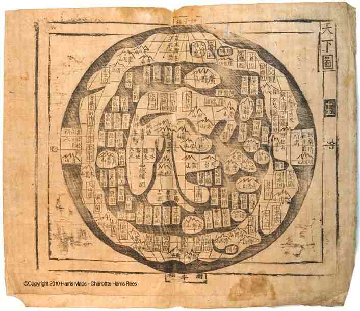
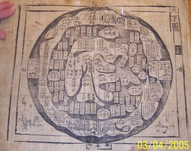
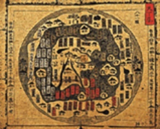
This is an interesing map from The Harris Map Collection. It may show that the Chinese were in the Americas prior to Columbus. This information is a
few years old, but it doesn't appear to have been discussed on ATS, and I haven't found much about it on the internet.
From what I understand from the articles,
this map is a copy of a map from the Shan Hai Jing around 2200 b.c.
I would like to know what everyone thinks about it....is the map real, an old fantasy map,
or someone just using it to sell a book?
en.wikipedia.org...

www.uglychinesecanadian.com...
www.asiaticfathers.com...
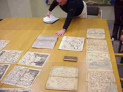
Hendon M. Harris III showing a part of the Harris Map Collection
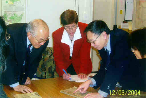
Dr. Hwa-Wei Lee, Chief, Asian Division, Library of Congress, Charlotte Rees, and
Dr. Xiaocong Li, Vice Director of Centre for the Ancient Chinese History Studies,
Peking University viewing the Harris Maps at the Library of Congress
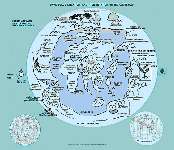
Below is a Variation (and Interpretation) of the above map by David Allen Deal
www.freerepublic.com...
I always question something such as this map, especially when someone is trying to use it to sell a book, but it is an interesting map, and could be very important if it were real.
There are suppose to be at least 23 other maps of this style in existence,
7 in the Harris Map Collection.
Has anyone else see any of the other maps like this one?
...or any of the maps in the Harris Map Collection?
From what I understand from the articles,
this map is a copy of a map from the Shan Hai Jing around 2200 b.c.
I would like to know what everyone thinks about it....is the map real, an old fantasy map,
or someone just using it to sell a book?
en.wikipedia.org...
Shan Hai Jing (simplified Chinese: 山海经; traditional Chinese: 山海經; pinyin: Shānhǎi Jīng; Wade–Giles: Shan Hai Ching; literally "Classic of the Mountains and Seas" or "Collection of the Mountains and Seas") is a Chinese classic text, and a compilation of early geography and myth. Versions of the text have existed since the 4th century BC,[1][2] and by the early Han Dynasty it had reached its final form.[2] It is largely a fabled geographical and cultural account of pre-Qin China as well as a collection of mythology. The book is about 31,000 words long, and is divided into eighteen sections; it describes over 550 mountains and 300 channels. The oldest part of the present book is sometimes referred separately as Wuzang Shanjing 五藏山經.
In 1973, Dr. Hendon Harris, Jr. published a book, “The Asiatic Fathers of America,” claiming that the ancient Chinese arrived to become patriarchs to many of America’s so-called aboriginals. The son of missionaries, Harris grew up in Taiwan, translation of the Shan Hai Jing his great avocation. But not until he discovered an old map, in an antique shop in Korea, of all places, did everything lock into place. The “Everything Under Heaven” map showed not only land masses roughly equaling the size and shape of Africa, Europe, and Australia, but also Fu Sang, the Americas.
www.uglychinesecanadian.com...
In 1972, Dr. Hendon M. Harris Jr., a third generation missionary born in Kaifeng China, was browsing in an antique shop in Korea when he came across an very old cartography book comprised of wood block-printed maps outlining ancient settlements in Korean. When he flipped through the pages, there was a map of the world. This map was Chinese. The Korean name for that type map is Ch’onhado meaning “Chinese map.” This map of the world not only documented known major land masses such as Asia, India, Africa Australia and Europe – many by their ancient names – also included both the continents of North and South America. Most shocking was that this map showed words describing China’s fabled Fu Sang written in an area on what is now called North America.
www.asiaticfathers.com...
From 1981 until 2003 most of the time the Harris collection was just in a box under the bed of Hendon, III. The heirs dared not believe that what their father said about them was correct.
Hendon M. Harris III showing a part of the Harris Map Collection
In 2003 there was a flurry of worldwide debate about whether the Chinese arrived in America before Columbus. At that time the Harris family took the maps to the Library of Congress where they remained for three years while they were being studied.
The History of Cartography, to which Charlotte was directed at the Library of Congress, states that the date of origin of this style map is unknown. It further tells that 72 percent of the place names on this map are from the Shan Hai Jing. However, the History of Cartography contends that while China, Korea, and Japan in the center of the map are real those countries on the outer rim are imaginary.
Dr. Hwa-Wei Lee, Chief, Asian Division, Library of Congress, Charlotte Rees, and
Dr. Xiaocong Li, Vice Director of Centre for the Ancient Chinese History Studies,
Peking University viewing the Harris Maps at the Library of Congress
Harris believed that the additional place names were added during the many times the maps were copied over the years. He believed that the "mother map" of this style was the long lost map that at one time accompanied the Shan Hai Jing. That would make the original copy of the map to be from 2200 B. C.
By the time of his death Dr. Harris was aware of 23 other similar maps of this style (in addition to his seven) in prestigious museums and collections around the world. He correctly surmised that there were probably a few more. In effect, the true meaning of these maps has been hidden for years - right in plain sight.
The Harris maps were printed from wood block. Most are on mulberry-bark paper and are written in classical Chinese. Although varying in ages they have only minimal differences. The oldest of the Harris maps are believed to be from the Ming dynasty. The map books themselves are Korean but the world map in each book is a Chinese map.
Names on the map, their locations, and descriptions in both the Shan Hai Jing and the fifth century Liang Shu, cemented his conviction that Chinese much further from Columbus than he from us traveled and documented vast portions of the not-so-New World.
There was Equal to Heaven Mountain, matching the location and description of Mt. McKinley, the highest point in North America.
Chasm of the Bright Mountains must surely refer to the Grand Canyon, for nowhere else in the world are there mountains renowned for their luminescence yet beneath the earth’s surface, and 1500 li from Fu Sang’s west coast, at that.
White Lake at Cha Hill corresponds in location and description to Mexico City’s Lake Texcoco, five interconnected bodies of water, since drained and much reduced.
Then there were the accounts of monk Hui Shan, who journeyed extensively through Fu Sang in the 5th century, only to return to laughter and dismissal at the royal court, eight centuries before Marco Polo got the same treatment. His tales of “Decorated Head Country”, on the Yucatan Peninsula, must indeed have sounded fabulous to those who had never seen Maya nobles and warriors in their ultra-elaborate head gear. Ridiculous too, the tales of Women’s Country, the matrilineal Hopi tribes with their “snake husbands”, men who saw the serpent as both their progenitor and protector.
Below is a Variation (and Interpretation) of the above map by David Allen Deal
www.freerepublic.com...
I always question something such as this map, especially when someone is trying to use it to sell a book, but it is an interesting map, and could be very important if it were real.
There are suppose to be at least 23 other maps of this style in existence,
7 in the Harris Map Collection.
Has anyone else see any of the other maps like this one?
...or any of the maps in the Harris Map Collection?
edit on 30-1-2012 by isyeye because: (no reason given)
This may have been discussed here before, but I do know...I think it was Ancient Aliens..the TV show..that did show the Bimini road off the Bahamas is
very closely related to Chinese architecture for building their ancient harbours.
I may be thinking about something completely different, , but I know I have heard reasonable proof that the Chinese had been here before Columbus before also.
I know that sounded like a total ramble, but I was agreeing with you OP...
Actually...I personally think Columbus was one of the LAST to actually discover America! I believe there were many others before hand, and have heard very reasonable theories to back that up before.
edit on 30-1-2012 by webpirate because: additional thoughts
This is the first I have seen this map.
I must say at first glance(and subsequent glances), it looks more like a disembodied liver than the land masses that it is purported to show.
The 're-drawing' takes quite a bit of liberty with not only a pencil, but an eraser also.
ETA: I believe that Chinese mariners visited the Americas long before Columbus, I just have a bit of trouble with that map.
edit on 30-1-2012
by butcherguy because: (no reason given)
The Jews were there before Columbus too,they became Cherokee Indians (:
And the Japanese.
And the Polynesians
.....the Irish The list goes on.
And the Japanese.
And the Polynesians
.....the Irish The list goes on.
edit on 30-1-2012 by theubermensch because: (no reason given)
edit on 30-1-2012 by
theubermensch because: (no reason given)
reply to post by webpirate
I have been scuba diving on the Bimini Roads...Great experience!
reply to post by butcherguy
When I think about the capabilities in mapping they may have had a few thousand years ago,
the map makes some sense. The "interpretation" does take some liberties, but the original is still interesting,
I have been scuba diving on the Bimini Roads...Great experience!
reply to post by butcherguy
When I think about the capabilities in mapping they may have had a few thousand years ago,
the map makes some sense. The "interpretation" does take some liberties, but the original is still interesting,
edit on 30-1-2012 by isyeye because: (no reason given)
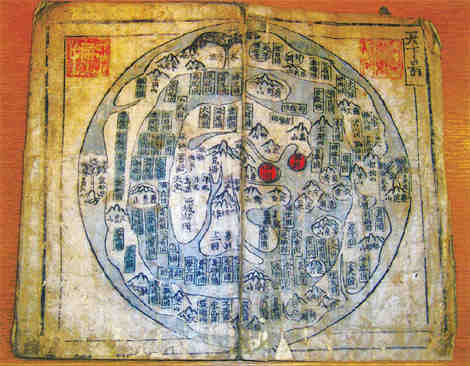
These are a couple other maps from The Harris Map Collection. They are very similar to the first map.
www.chinadaily.com.cn...
www.chinesediscoveramerica.com...
www.chinaexpat.com...
This is a good site that has several similar maps and helps explain them.
cartographic-images.net...
www.chinadaily.com.cn...
www.chinesediscoveramerica.com...
Though the Harris Maps themselves are in seven Korean atlases of various dates, thought to be from the 15th through 19th centuries, the author demonstrates that most Asian maps of that era descended from Chinese maps.
A third century Chinese text mentioned an incident in the 18th century BC involving a world map of the Ch’onhado/Tian Xia style. The source document for the world map is from around 2000 BC and discussed in accurate detail a beautiful land (Fu Sang) to the east of China. The map shows Fu Sang on the American coastline.
www.chinaexpat.com...
Many believe that, long before Columbus, Zheng He, or even the Vikings, the Chinese sailed to the Americas. Some of the most compelling research was compiled by Dr. Hendon M. Harris, Jr. (1916 – 1981), a body of work carried on by his son, Hendon M. Harris III. This is a re-post from the latter’s blog, Chinese Discover America.
"In order for ancient Trans Pacific travel to the Americas to have been possible for the Chinese and other Asians they would have had to have the technology that would make such a trip possible. Only desperate men with no regard for their lives would forage far out into the ocean without navigational knowledge and the tools necessary to use that knowledge. That is precisely why it took Europeans until the period between 1487 & 1577 (90 years) after The Inconvenient Maps and new navigational information and technology from China had shown up in Europe to develop the confidence to sail into “The European Age of Discovery”.
What is apparently hard for the world to accept is that Asians had the technology to make such trips from ancient times. It isn’t a wild claim. Scholarly works by recognized experts on these topics such as Joseph Needham, Robert Temple and many others have set up the basis for these theories to be expressed and explored. (It must be stated here and clearly understood that to my knowledge neither Dr. Needham or Dr. Temple have ever made claims or theorized on the matter of ancient Chinese or Asian Trans Pacific travel.) What they both have shown through their research is that the ancient Chinese had developed and maintained major technological knowledge and equipment well in advance of their European counterparts. These inventions and discoveries included among many others advanced astronomy dating back to 2136 BC, the magnetic compass, recorded navigational ability and shipbuilding skills that produced fleets of ships the size of which wouldn’t be rivaled until the mid 20th century."
This is a good site that has several similar maps and helps explain them.
cartographic-images.net...
edit on 30-1-2012 by isyeye because: (no
reason given)
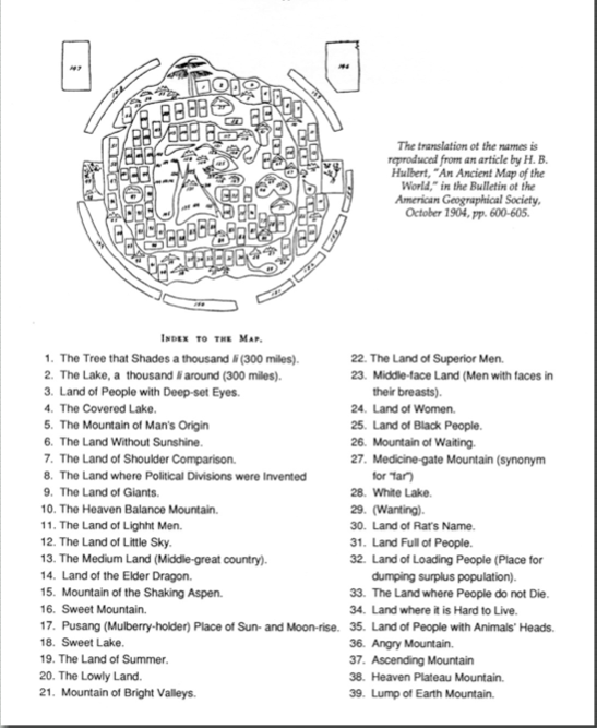
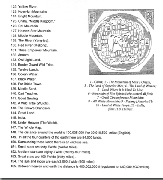
Interestingly one of the links below gives a translation of some of the writing dealing with the map
Well ....they were just SLIGHTLY off
That link also has a translation of the terms on the map - quite fantastic to say the least its good to see the Chinese were also into fabulous lands and saying that in certain places 'there be dragons'
The link
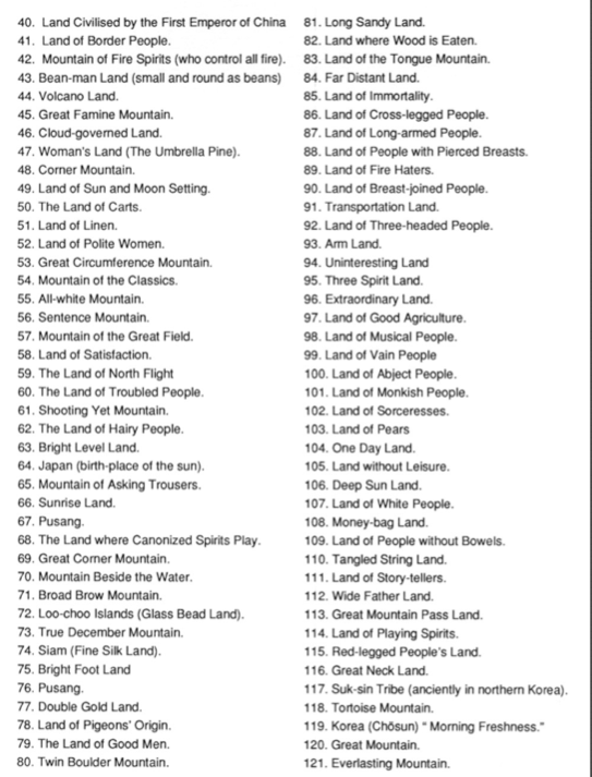
Place 109 sounds rather - unpleasant
Around the edge are arranged some statements of a general nature, namely, that the distance around the world is some 30 million miles; that the world contains 84,000 different countries; that it is surrounded by a limitless ocean; that the stars vary in width from 12 to 30 miles; that the sun and moon are 900 miles wide; and that the heavens and the earth are separated by a distance of 120,000,600 miles
Well ....they were just SLIGHTLY off
That link also has a translation of the terms on the map - quite fantastic to say the least its good to see the Chinese were also into fabulous lands and saying that in certain places 'there be dragons'
The link
Place 109 sounds rather - unpleasant
edit on 31/1/12 by Hanslune because: (no reason given)
reply to post by butcherguy
not surprising..it is said that Zheng He's flagship is as large as a modern day aircraft carrier so it is no Chinese junk. They invented the south pointing compass and ship rudder as well as compartmental ship building. Their sail arrangement allow them to sail upwind and only takes one or two persons to unfurl. Go to Ancient Chinese Inventions or Things Europeans Did Not Invent and you can see for yourself
not surprising..it is said that Zheng He's flagship is as large as a modern day aircraft carrier so it is no Chinese junk. They invented the south pointing compass and ship rudder as well as compartmental ship building. Their sail arrangement allow them to sail upwind and only takes one or two persons to unfurl. Go to Ancient Chinese Inventions or Things Europeans Did Not Invent and you can see for yourself
reply to post by isyeye
Very interesting info thanks Isyeye.
I have to say though that the "interpreted" map drawn by David Allen Deal looks nothing like the Harris Map! Definitely some "artistic licence" in evidence there!
However, if true, it is far earlier even than the voyages of Admiral Zhang He en.wikipedia.org..." target="_blank" class="postlink">en.wikipedia.org...
I really am rubbish with technology so hopefully that works! I always found it slightly suspicious that Zheng He went every direction but due East - that seems rather strange to be honest although may have something to do with wind directions and ocean currents. I have never sailed so the South China Seas so i have no idea on that to be honest!
edit on 3-2-2012 by Flavian because: (no reason given)
Originally posted by slanteye
reply to post by butcherguy
not surprising..it is said that Zheng He's flagship is as large as a modern day aircraft carrier so it is no Chinese junk. They invented the south pointing compass and ship rudder as well as compartmental ship building. Their sail arrangement allow them to sail upwind and only takes one or two persons to unfurl. Go to Ancient Chinese Inventions or Things Europeans Did Not Invent and you can see for yourself
The problem though is that Zheng He was around in the 1300's. The Vikings got to America before that.
Originally posted by slanteye
reply to post by butcherguy
not surprising..it is said that Zheng He's flagship is as large as a modern day aircraft carrier so it is no Chinese junk.
Aircraft carrier? Somewhat of an exaggeration
Comparison of one of Columbus' ships and one of Zheng's. With wooden ship there is a limit to the size you can build due to the woods flexibility. Until they started adding iron fittings you weren't going over 3,750 tons
edit on 3/2/12 by Hanslune because: (no reason given)
reply to post by Hanslune
The ships the people like Columbus undertook voyages on really just increase my admiration for explorers from that time.
I often go over to Whitby for a wander. They sometimes have a full size replica of HMS Endeavour there (Cook's ship to Australia) and my god is that thing tiny. I certainly would not fancy a trek across the North Sea in it let alone the Pacific! However, they have made the journey several times in the replica, usually with a mix of young Aussies and Brits crewing it.
I have to say that in comparison, Zheng's looks like total luxury.
Originally posted by Flavian
reply to post by Hanslune
The ships the people like Columbus undertook voyages on really just increase my admiration for explorers from that time.
I often go over to Whitby for a wander. They sometimes have a full size replica of HMS Endeavour there (Cook's ship to Australia) and my god is that thing tiny. I certainly would not fancy a trek across the North Sea in it let alone the Pacific! However, they have made the journey several times in the replica, usually with a mix of young Aussies and Brits crewing it.
I have to say that in comparison, Zheng's looks like total luxury.
You might want to look at what the Vikings travelled in and then the Polynesians; they were the kings of long distance oceanic travel
reply to post by Hanslune
In in York Hanslune - we have Viking festivals every year. My surname is a cross of old English and Norse (similar meanings and pronunciation but then they really were from the same stock anyway!).
I have actually done the Dragon Race several times and been to a fair few boat burning festivals also. I have to say, despite appearances i would actually be far more comfortable on a Viking ship than on the "technically superior" (i seriously question that) ships of Cook's era. The Viking ships travelled through the water, Cooks type of ship more seems to get there by luck! (not good handling, that's for sure!).
Have to say, i'm really spoilt here. We do the Roman festival here every year too, and are just down the road (in both directions) of one of the most significant battles of the Civil War (Marston Moor) in one direction and the Battle of Towton (totally different civil war, houses of York and Lancaster) in the other - the Battle of Towton was actually the bloodiest ever in the UK and gave its name to the local stream (known as either Red Beck or the Killing Beck).
Plus Stamford Bridge about 10 minutes away and also the site of the Battle of Fulford (pre battle to Stamford Bridge). I think if you haven't been, you would quite like it round here
It's unlikely, and because of the cultural context and relationship of names to legendary places in China (real places with legends attached to them)
it's more of a work of fantasy than a travelogue. Also, the map isn't that old -- it's no more than 2400 years old and (judging from the
appearance of the manuscript) actually less than that in the versions shown. In addition, they didn't actually know the shape of Africa (even
generally) or Eastern Europe and Britain.
The sailing ship that someone posted was different than the ships available at the time the book was written. Chinese technology, like other technology, advanced over the centuries.
The Chinese apparently had visited the Americas, but not at quite so early a date. Remember that the empire of that time was NOT the size and shape of today's empire and trekking just to Alaska would have required a journey of many months and a voyage. They'd have had to have some very important reason for going into those distant and stormy seas (only accessible during a part of the year) -- it would have had to do with trade rather than exploring new lands.
Conquering the lands next door (Mongolia, Russia, Tibet, Japan, Korea, etc, etc) was much easier than sending an army to a far away place where you couldn't easily supply or support them.
Originally posted by Flavian
reply to post by Hanslune
In in York Hanslune - we have Viking festivals every year. My surname is a cross of old English and Norse (similar meanings and pronunciation but then they really were from the same stock anyway!).
I have actually done the Dragon Race several times and been to a fair few boat burning festivals also. I have to say, despite appearances i would actually be far more comfortable on a Viking ship than on the "technically superior" (i seriously question that) ships of Cook's era. The Viking ships travelled through the water, Cooks type of ship more seems to get there by luck! (not good handling, that's for sure!).
Have to say, i'm really spoilt here. We do the Roman festival here every year too, and are just down the road (in both directions) of one of the most significant battles of the Civil War (Marston Moor) in one direction and the Battle of Towton (totally different civil war, houses of York and Lancaster) in the other - the Battle of Towton was actually the bloodiest ever in the UK and gave its name to the local stream (known as either Red Beck or the Killing Beck).
Plus Stamford Bridge about 10 minutes away and also the site of the Battle of Fulford (pre battle to Stamford Bridge). I think if you haven't been, you would quite like it round here
Yes I've been to the festival and the museum in York several times my wife is a Mancunian so I know that area of England well, some years ago I spent a few vacation going to all the battlefields in England, Towton has always stuck in my mind too as the bloodiest, 25,000-30,000 men killed in one day
reply to post by Byrd
And China didn't really go in for conquering the lands next door either. Take the Mongols and the Tartar Russians - rather than fight and invade, they preferred the use of spies and bribes to get them to fight each other instead. That was the main reason for Genghis going apoplectic inside China!
And China didn't really go in for conquering the lands next door either. Take the Mongols and the Tartar Russians - rather than fight and invade, they preferred the use of spies and bribes to get them to fight each other instead. That was the main reason for Genghis going apoplectic inside China!
edit on 6-2-2012 by Flavian because: (no reason given)
reply to post by Hanslune
Towton was truly terrible but it is such a pretty little area it is hard to marry the slaughter in your minds eye when you go there. And all that slaughter was with swords, pikes, maces, etc.
What confuses me is why that period isn't referred to as the first English Civil War. Two rival Houses slugging it out for the crown, that seems fairly civil war like to me!
The Battle of Fulford is also fairly remarkable in that so little is known about it. They have found the site (well, they are fairly sure they have). For those not in the know, this was where the Northern Lords engaged Harald Hardrada before King Harold's army got north for the battle of Stamford Bridge - indeed, the Vikings were still celebrating when the first of King Harold's troops arrived and took the bridge at Stamford. It was also a close run thing between the two most feared warrior types in Europe at the time - the Anglo Saxon shield wall (feared everywhere) and the battle prowess of Hardrada (the most feared military commander of the period).
And to the OP, sorry for going so far off topic!
reply to post by Flavian
No problem at all....I'm quite enjoying what you are discussing.
I only wish I had something interesting to add.
And to the OP, sorry for going so far off topic!
No problem at all....I'm quite enjoying what you are discussing.
I only wish I had something interesting to add.
new topics
-
Is the origin for the Eye of Horus the pineal gland?
General Conspiracies: 1 hours ago -
Man sets himself on fire outside Donald Trump trial
Mainstream News: 1 hours ago -
Biden says little kids flip him the bird all the time.
2024 Elections: 1 hours ago -
The Democrats Take Control the House - Look what happened while you were sleeping
US Political Madness: 2 hours ago -
Sheetz facing racial discrimination lawsuit for considering criminal history in hiring
Social Issues and Civil Unrest: 2 hours ago -
In an Historic First, In N Out Burger Permanently Closes a Location
Mainstream News: 4 hours ago -
MH370 Again....
Disaster Conspiracies: 4 hours ago -
Are you ready for the return of Jesus Christ? Have you been cleansed by His blood?
Religion, Faith, And Theology: 7 hours ago -
Chronological time line of open source information
History: 8 hours ago -
A man of the people
Medical Issues & Conspiracies: 9 hours ago
top topics
-
In an Historic First, In N Out Burger Permanently Closes a Location
Mainstream News: 4 hours ago, 14 flags -
The Democrats Take Control the House - Look what happened while you were sleeping
US Political Madness: 2 hours ago, 8 flags -
A man of the people
Medical Issues & Conspiracies: 9 hours ago, 8 flags -
Thousands Of Young Ukrainian Men Trying To Flee The Country To Avoid Conscription And The War
Other Current Events: 14 hours ago, 7 flags -
Iran launches Retalliation Strike 4.18.24
World War Three: 17 hours ago, 6 flags -
4 plans of US elites to defeat Russia
New World Order: 11 hours ago, 4 flags -
Man sets himself on fire outside Donald Trump trial
Mainstream News: 1 hours ago, 4 flags -
12 jurors selected in Trump criminal trial
US Political Madness: 17 hours ago, 4 flags -
Biden says little kids flip him the bird all the time.
2024 Elections: 1 hours ago, 3 flags -
Sheetz facing racial discrimination lawsuit for considering criminal history in hiring
Social Issues and Civil Unrest: 2 hours ago, 3 flags
active topics
-
12 jurors selected in Trump criminal trial
US Political Madness • 80 • : ImagoDei -
The Democrats Take Control the House - Look what happened while you were sleeping
US Political Madness • 17 • : matafuchs -
Biden says little kids flip him the bird all the time.
2024 Elections • 7 • : chiefsmom -
Man sets himself on fire outside Donald Trump trial
Mainstream News • 13 • : KKLOCO -
Israeli Missile Strikes in Iran, Explosions in Syria + Iraq
World War Three • 101 • : CarlLaFong -
Thousands Of Young Ukrainian Men Trying To Flee The Country To Avoid Conscription And The War
Other Current Events • 26 • : Lazy88 -
George Knapp AMA on DI
Area 51 and other Facilities • 27 • : TheValeyard -
4 plans of US elites to defeat Russia
New World Order • 35 • : Oldcarpy2 -
Sheetz facing racial discrimination lawsuit for considering criminal history in hiring
Social Issues and Civil Unrest • 6 • : chiefsmom -
Is the origin for the Eye of Horus the pineal gland?
General Conspiracies • 1 • : ARM19688