It looks like you're using an Ad Blocker.
Please white-list or disable AboveTopSecret.com in your ad-blocking tool.
Thank you.
Some features of ATS will be disabled while you continue to use an ad-blocker.

Denver Airport Allows Camera Crew in Underground Facility
page: 9share:
Originally posted by zorgon
Originally posted by jerryznv
Looks like a map a 10 year old did with his crayon!
Some supposed "insider" released this map...and that is the best he could do?
Looks ridiculous to me!
Oh good grief... there are several threads on that system here at ATS
The data and map come from the RAND corporation PDFs available at DTIC (Defense Technical Information Center) and that map was also published in the LA times in 1972
I could link the threads for you but what is the point? You wouldn't look anyway
Interesting Zorgon. I didn't know that. I've been following for some time, you seem to be pretty in tune.
As for the skeptics....well, my opinion is that someone who signs up to a conspiracy site just to debunk every conspiracy must have some alternative agenda other than truthseeking....
Originally posted by zorgon
ATS used to be the premiere conspiracy site... stories like this made this the come to place to speculate on ideas like this, Now its more like debunker central and the fun of looking and speculating is gone.
Even YOU used to be into it... Pity that
Who said you can't speculate? Or is it that you prefer everyone be allowed to speculate without having a differing opinion (debunking?) presented?
Maybe some people have been "into" the conspiracy realm long enough to know when it's horse# (see the French psychic thread of late). Sounds like sour grapes just because everyone isn't high-fiving each other in utter 100% agreement.
By the way, love your avatar? Is that chain-mail or tin-foil?
reply to post by edgecrusher2199
Could be for fallout purposes or end of the world shelter.
Some also believe that this is also a alien base like Dulce or Roswell. I'm sure there is something there though.
-SAP-
Could be for fallout purposes or end of the world shelter.
Some also believe that this is also a alien base like Dulce or Roswell. I'm sure there is something there though.
-SAP-
Americas 14,000mph secret transit system
www.abovetopsecret.com...
At least some others may be interested
www.dtic.mil...
www.abovetopsecret.com...
At least some others may be interested
1972
Defense Technical Information Center
Accession Number: ADA032172
Citation Status: ACTIVE
Title: The Very High Speed Transit System,
Fields and Groups : 130600 - SURFACE TRANSPORTATION AND EQUIPMENT
Corporate Author: RAND CORP SANTA MONICA CALIF
Personal Author(s): Salter,R. M.
Report Date: AUG 1972
Media Count: 19 Pages(s)
Report Number(s): P-4874 (P4874)
Descriptors:
*TRANSPORTATION, MAGNETIC FIELDS, SUPERCONDUCTORS, TUNNELS, DRIVES, VEHICLES, ENVIRONMENTAL PROTECTION, ENERGY CONSERVATION, ELECTROMAGNETISM, ELECTRICAL EQUIPMENT.ZTRANSPORTATION, MAGNETIC FIELDS, SUPERCONDUCTORS, TUNNELS, DRIVES, VEHICLES, ENVIRONMENTAL PROTECTION, ENERGY CONSERVATION, ELECTROMAGNETISM, ELECTRICAL EQUIPMENT.Z
Identifiers:
*Magnetically levitated vehicles, *Tubetrains, *Very high speed transit systems
Abstract:
The Very High Speed Transit or 'VHST' concept was put forward some years ago in response to the search for a pollution-free transport method that could operate at speeds competitive with aircraft. The general principles are relatively straightforward: Electromagnetically levitated and propelled cars in an evacuated tunnel. The VHST's 'tubecraft' ride on, and are driven by, electromagnetic (EM) waves much as a surfboard rides the ocean's waves. The EM waves are generated by pulsed or by oscillating currents in electrical conductors that form the 'roadbed' structure in the evacuated 'tubeway.' Opposing magnetic fields in the vehicle are generated by means of a loop of superconducting cable carrying on the order of a million amperes of current. The system is highly conservative of energy. Economic, environmental and technical aspects are briefly considered.
Distribution Limitation(s): 01 - APPROVED FOR PUBLIC RELEASE
Source Code: 296600
Document Location: DTIC AND NTIS
Geopolitical Code: 0628
Supplementary Notes: Previously announced as N73-13990.
Citation Updated: 06 MAR 2002
Distribution Statement : APPROVED FOR PUBLIC RELEASE
Members of the public may purchase hardcopy documents from the National Technical Information Service.
www.dtic.mil...
reply to post by COconspiracyguy
Actually...no it's not!
Maps of any kind usually (certainly ones from the government) contain certain features like a compass...scale size...labels, etc...this is a poor representation of anything...it's terrible!
Google some images of maps from 1800...ten times better than this!
Actually, the map is pretty sophisticated.
Actually...no it's not!
Maps of any kind usually (certainly ones from the government) contain certain features like a compass...scale size...labels, etc...this is a poor representation of anything...it's terrible!
Google some images of maps from 1800...ten times better than this!
I dont assign any nefarious meaning to the airport but it very well could house a government operation secretly hiden below.
Why does anyone think that is impossible? The only reason is because people associate that operation with NWO crazy alien crap.
I point you to the Greenbriar hotel which for decades housed a secret government bunker. Built as part of the continuation of government plan to house the congress in case of nuclear war. It was built using methods very similar to DIA (different contractors and such). There is nothing insane about thinking that the DoD would take advantage of a large scale construciton project that was being built to slip in a bunker facility. That in and of itself does not mean they plan to use DIA as some sort of modern day concentration camp.
The fact that it contains hideous art work should be of no surprise....its a government building! Who do you think keeps these so called artists employed? No one would actually buy that garbage only the NEA is stupid enough to waste tax payers dollars paying vastly inflated prices for it. Real artists can get work commercially they dont need government funding.
Not sure if this has been mentioned yet because I haven't read through all the pages yet.
Did anyone else notice around the 2:10 mark when they are in the elevator and the number 4 is visible, the elevator starts moving down as they cut to another scene? Assuming 4 represents the 4th floor, that would obviously mean there is another floor if the elevator was moving down...
Did anyone else notice around the 2:10 mark when they are in the elevator and the number 4 is visible, the elevator starts moving down as they cut to another scene? Assuming 4 represents the 4th floor, that would obviously mean there is another floor if the elevator was moving down...
edit on
27-1-2012 by edgecrusher2199 because: Wrong Info
Originally posted by jerryznv
reply to post by COconspiracyguy
Actually, the map is pretty sophisticated.
Actually...no it's not!
Maps of any kind usually (certainly ones from the government) contain certain features like a compass...scale size...labels, etc...this is a poor representation of anything...it's terrible!
Google some images of maps from 1800...ten times better than this!
Well, I've spent many years buying and selling ephemera, maps, and books. If I had this map, it would be one of my prize possessions. I looks legit to me. Would be nice to examine it physically.
But Zorgon stated that this map has been proven to be legit. You have shown nothing, but your opiion. And since you are making a great effort to debunk this thread, which I for one find on point, I find your opinion less convincing.
To reflect on a few criticisms of the myths and conspiracy theories around DIA:
1. Location IS quite suspicious if you take into consideration that the functional (though dated) Stapleton was 19 miles closer to the urban area. Unless of course you think 5 billion is a normal cost for urban noise reduction.
2. The horse looks demonic. That's not interpretation. It might be "good" demonic or "bad" demonic based on your personal tastes, but that is some weird decoration. Notice I said "weird" and not "NWO beacon."
3. Burying buildings. IF that is true, it's weird. I'm not saying it isn't. I just don't know.
4. The artwork does seem to represent some Malthusian "Georgia Guidestones" sensibilities....but harmony with nature is Native American for sure and that's the stated inspiration. Still a weird choice.
5. Mason plate. Crazy. Could be some sick joke, knowing people would buzz a ton if they put New World Airport Commission on it. Kind of a big, masonic middle finger to the conspiracy nuts. I dunno. Point is, as someone already stated, it's made up. Doesn't exist. So it's either a joke, a tradition, or significant in some other way.
It doesn't have to be a reptilian genocidal NWO plot to be weird. A continuity of government contingency plan seems like it could be involved, since it's only 75 miles or so from Colorado Springs and Cheyenne Mountain Operations Center, and if there were a tunnel built (tunnels that long do exist, Delaware Aqueduct for one) it could serve as another point of entry in the event that Peterson was hit as a strategic target.
Also, I think some of the "it's a myth, you conspiracy nuts" are taking things out of context. It's not intellectually fair to pull each one out, "debunk it," and then not address the fact that there's so many oddities in one place. The fact that they're all in the same place is relevant, and to analyze them outside of that context is dishonest.
A demon horse and Anubis statue....explainable, sorta.
Weird murals with dead kids and stormtroopers....explainable, sorta.
Billions over budget....explainable,sorta.
Burying buildings....explainable, kinda.
Masonic capstone with made up organization...explainable, sorta.
All of this at one airport? Much less explainable. Also, as one user said, IF you believe in the traditional narratives of the elites, this could very much be a "let he who hath knoweldge, calculate!" sort of a thing....since we're all fairly stupid and powerless and an insult to the species anyway.
That said, I'm withholding judgement myself until I hear about Air Force One disappearing down a ramp at the end of the north runway. But at that point, we're probably all dead anyway.
reply to post by COconspiracyguy
Well that is just not true...I would love to see some convincing proof that DIA is a government installation of some sort!
Unfortunately...there is no proof of that now is there...otherwise this thread would be at the top of the ATS forum and probably the headlines of every paper in the U.S.
So despite you opinion that I am trying to debunk this thread...you are wrong...I would like to see it proved...not debunked at all!
As far as being convincing...I am not trying to be...I question everything...you should too...it's called being skeptical!
And since you are making a great effort to debunk this thread, which I for one find on point, I find your opinion less convincing.
Well that is just not true...I would love to see some convincing proof that DIA is a government installation of some sort!
Unfortunately...there is no proof of that now is there...otherwise this thread would be at the top of the ATS forum and probably the headlines of every paper in the U.S.
So despite you opinion that I am trying to debunk this thread...you are wrong...I would like to see it proved...not debunked at all!
As far as being convincing...I am not trying to be...I question everything...you should too...it's called being skeptical!
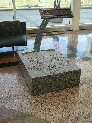
Originally posted by Jiggyfly
5. Mason plate. Crazy. Could be some sick joke, knowing people would buzz a ton if they put New World Airport Commission on it. Kind of a big, masonic middle finger to the conspiracy nuts. I dunno. Point is, as someone already stated, it's made up. Doesn't exist. So it's either a joke, a tradition, or significant in some other way.
How is it made up? In the Jesse Ventura film he is standing in front of it... its right there on camera
At 6:38 Youtube Link
Here is the photo of it
edit on 27-1-2012 by zorgon because: (no reason
given)
DENVER IS ALSO A GOOD PLACE... FOR CIA
www.washingtonpost.com...
CIA Plans to Shift Work to Denver
by Dana Priest
Washington Post Staff Writer
Friday, May 6, 2005
The CIA has plans to relocate the headquarters of its domestic division, which is responsible for operations and recruitment in the United States, from the CIA's Langley headquarters to Denver, a move designed to promote innovation, according to U.S. intelligence and law enforcement officials.
The Denver suburb of Aurora is home to the little-known Aerospace Data Facility. Located inside Buckley Air Force Base, it has become the major U.S.-based technical downlink for intelligence satellites operated by the military, the National Security Agency and the National Reconnaissance Office, according to military and government documents obtained by William Arkin, author of "Code Names," a book about secret military plans and programs.
About 70 miles away, the U.S. Northern Command, based at Peterson Air Force Base, in Colorado Springs, is tasked with homeland defense and has been increasing its domestic intelligence work.
It could not be learned whether the CIA's Denver plans are linked to the presence of either facility.
edit on 27-1-2012 by Arken because: (no reason given)
reply to post by Arken
Buckley already contains a bunch of ABC agencies...some I dont even know of....
Buckley already contains a bunch of ABC agencies...some I dont even know of....
Originally posted by jerryznv
As far as being convincing...I am not trying to be...I question everything...you should too...it's called being skeptical!
Questioning everything and not doing any research or following links to presented data, but merely stating an opinion that something is made by a 10 year old when in fact it is in an official publication is NOT being a skeptic...
that is called debunking... and it serves no positive purpose
Originally posted by greeneyedleo
reply to post by Arken
Buckley already contains a bunch of ABC agencies...some I dont even know of....
Spent some time at Buckley a while back. It never ceased to amaze me how the civilian industrial
businesses in the area were tightly knit with the base..
The whole place is one giant secret right under the publics nose, just like DIA>
reply to post by zorgon
Try not to misquote me zorgon...it's a bad habit you seem to do a lot of...I said it "looks" like something a 10 year old did!
As for a link...you didn't come along with one until long after my original post was up...so stop with the insults!
I don't care when it was published...or by who...the map does obviously exist....however accurate or inaccurate the indication is!
Would you like me to link an "officially published" map of mickey mouses house...does that make it undeniable proof of existence?
Questioning everything and not doing any research or following links to presented data, but merely stating an opinion that something is made by a 10 year old when in fact it is in an official publication is NOT being a skeptic...
Try not to misquote me zorgon...it's a bad habit you seem to do a lot of...I said it "looks" like something a 10 year old did!
As for a link...you didn't come along with one until long after my original post was up...so stop with the insults!
I don't care when it was published...or by who...the map does obviously exist....however accurate or inaccurate the indication is!
Would you like me to link an "officially published" map of mickey mouses house...does that make it undeniable proof of existence?
edit on 27-1-2012 by jerryznv because: (no reason given)
Originally posted by COconspiracyguy
Originally posted by greeneyedleo
reply to post by Arken
Buckley already contains a bunch of ABC agencies...some I dont even know of....
Spent some time at Buckley a while back. It never ceased to amaze me how the civilian industrial
businesses in the area were tightly knit with the base..
The whole place is one giant secret right under the publics nose, just like DIA>
QFT
In another thread I mentioned my father (the thread was on the Star Wars program). He was the director of aerospace engineering for the USAF from 1990- 1998 and designed at least 4 of the (giant white golf balls) satelite receptors on Buckley AFB. After he retired in 1998 from active duty he took several civilian VP positions at Lockhead Martin, BAE systems (google earth), and ITT (where he works to this day). He basically told me when he left the USAF command, he kept the same projects just got paid more to continue working on them.
He literally went from military to civilian without any drop off on his projects.
God Bless,
new topics
-
VirginOfGrand says hello
Introductions: 27 minutes ago -
Should Biden Replace Harris With AOC On the 2024 Democrat Ticket?
2024 Elections: 57 minutes ago -
University student disciplined after saying veganism is wrong and gender fluidity is stupid
Education and Media: 3 hours ago -
Geddy Lee in Conversation with Alex Lifeson - My Effin’ Life
People: 4 hours ago -
God lived as a Devil Dog.
Short Stories: 4 hours ago -
Police clash with St George’s Day protesters at central London rally
Social Issues and Civil Unrest: 6 hours ago -
TLDR post about ATS and why I love it and hope we all stay together somewhere
General Chit Chat: 7 hours ago -
Hate makes for strange bedfellows
US Political Madness: 9 hours ago
top topics
-
Hate makes for strange bedfellows
US Political Madness: 9 hours ago, 17 flags -
Who guards the guards
US Political Madness: 12 hours ago, 13 flags -
Police clash with St George’s Day protesters at central London rally
Social Issues and Civil Unrest: 6 hours ago, 8 flags -
TLDR post about ATS and why I love it and hope we all stay together somewhere
General Chit Chat: 7 hours ago, 5 flags -
University student disciplined after saying veganism is wrong and gender fluidity is stupid
Education and Media: 3 hours ago, 5 flags -
Should Biden Replace Harris With AOC On the 2024 Democrat Ticket?
2024 Elections: 57 minutes ago, 4 flags -
Has Tesla manipulated data logs to cover up auto pilot crash?
Automotive Discussion: 13 hours ago, 2 flags -
Geddy Lee in Conversation with Alex Lifeson - My Effin’ Life
People: 4 hours ago, 2 flags -
God lived as a Devil Dog.
Short Stories: 4 hours ago, 2 flags -
VirginOfGrand says hello
Introductions: 27 minutes ago, 0 flags
active topics
-
Should Biden Replace Harris With AOC On the 2024 Democrat Ticket?
2024 Elections • 13 • : DBCowboy -
Candidate TRUMP Now Has Crazy Judge JUAN MERCHAN After Him - The Stormy Daniels Hush-Money Case.
Political Conspiracies • 736 • : RazorV66 -
1980s Arcade
General Chit Chat • 23 • : McTech2 -
"We're All Hamas" Heard at Columbia University Protests
Social Issues and Civil Unrest • 260 • : Xtrozero -
They Killed Dr. Who for Good
Rant • 68 • : Lazy88 -
Terrifying Encounters With The Black Eyed Kids
Paranormal Studies • 67 • : daskakik -
House Overwhelmingly Passes Funding for Ukraine, Israel and Taiwan
US Political Madness • 61 • : Xtrozero -
Lawsuit Seeks to ‘Ban the Jab’ in Florida
Diseases and Pandemics • 28 • : worldstarcountry -
VirginOfGrand says hello
Introductions • 0 • : VirginOfGrand -
-@TH3WH17ERABB17- -Q- ---TIME TO SHOW THE WORLD--- -Part- --44--
Dissecting Disinformation • 630 • : RookQueen2