It looks like you're using an Ad Blocker.
Please white-list or disable AboveTopSecret.com in your ad-blocking tool.
Thank you.
Some features of ATS will be disabled while you continue to use an ad-blocker.

A Disk in the waters around the Mysterious Johnston Atoll, in the middle of Pacific Ocean.
page: 1share:
THE DISK
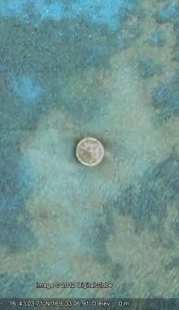
What is this? A structure, a natural formation or something that hover above the ocean?
I found this strange circular structure/object in the water of Johnston Atoll.
This remote place is classified as "Territory not incorporated of the United States" under control and military jurisdiction of Navy, that is does not allow the complete application of the American Constitution. Nearby the atoll, there are also very unusual and symmetrical channels or hidden submerged structures that are artificials. The entire atoll is artificial. In fact, other islands, Akau and Hikina, from 1940' to 1960' growth and built by dradging. The entire area was a nuclear and chemical weapons test site and a waste storage facility JACADS.
Strangely, this area is also incorporated in 2009 in the Pacific Remote Islands Marine National Monument
There were "rumors" of a "Secret Diplomatic Meeting" between, Aliens and governments representetives right in 2009 . The Story
A very remote and mysterious place where to transact secret business....
To Mods: feel free to move in appropriate forum.
Thx
edit on 21-1-2012 by Arken because: (no reason given)
This could be a concrete post for a lighthouse. But it would not make much sense here. Nice thread and links, have to read them..
Interesting! In reading a bit of history that place has been used for everything from nuclear bomb tests, spy satellite launches to chemical weapons
dumping area. Its hard to say what that is, it could honestly be related to any of the things I just listed.
However, I bet there is still enough nastiness around there to keep people at bay.
However, I bet there is still enough nastiness around there to keep people at bay.
There seems to be several of these strategically placed around the world.
Probably radar platforms strategically placed by our military to monitor foreign naval activity - like AWACs.
Probably radar platforms strategically placed by our military to monitor foreign naval activity - like AWACs.
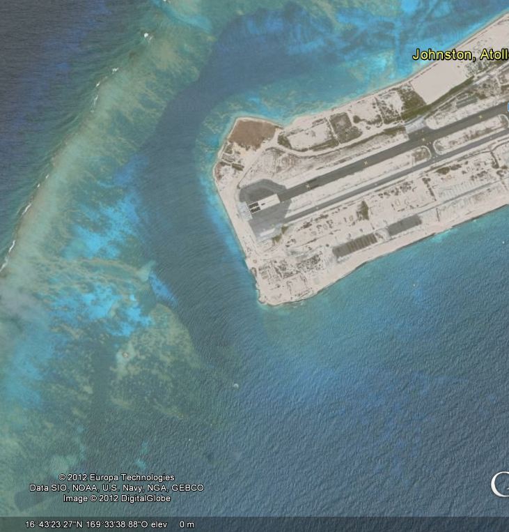
Wow,that's strange...could be some kind of containment boon covering something protruding from the ocean floor....I noticed from the second pic there
is another to the far right.....weird or what?
kewl find
interesting looking place
thanks for bringing it up ...
now I will go read more
interesting looking place
thanks for bringing it up ...
now I will go read more
Never really read much on the atoll until now, I knew it was used for military purposes, but not much more than that.
This is what I learned:
The atoll is no longer under control of the US Navy, it is controlled now by United States Fish and Wildlife Service of the Department of the Interior as part of the Pacific Remote Islands Marine National Monument. President Bush reclassified it in 2009.
The size of the atoll has increased from its original size through coral dredging to make room for the naval infrastructure. (This would for the seemingly man-made features shown in the video, they ARE man made.)
As far as the circular disk, no clue what that could be, but it is probably something related to the dredging or perhaps it is a canister left over frm the chemical weapons incineration that occurred there in 2003.
Thanks Wikipedia for not being blacked out today.
never heard of this location but I can totally see it being some sort of forward-supply base for our submarine/naval fleets - hence the runway.
Looks fairly modernized as well for simply a "former test site"
Looks fairly modernized as well for simply a "former test site"
Ok well I am usually the last person to bring something like this up, but I do believe I have found an anomaly here.
Looking in google maps at some sat images of the atoll, there does appear to be some altering to the image.
In my post above stated that the 'man-made' images in the video were probably because they are manmade structures due to the dredging.
I still think they are, but this is what I found interesting
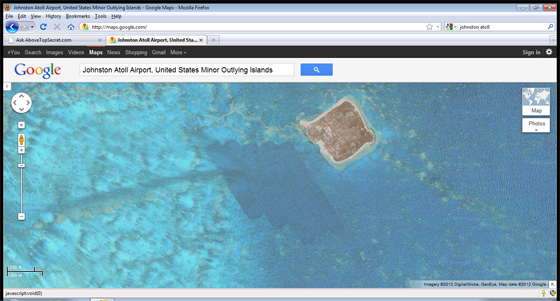
Do these images appear to have brushstrokes in them from photoshop or another imaging program?
These are the two smaller outlying islands from the main atoll where the airstrip is located.
Looking in google maps at some sat images of the atoll, there does appear to be some altering to the image.
In my post above stated that the 'man-made' images in the video were probably because they are manmade structures due to the dredging.
I still think they are, but this is what I found interesting
Do these images appear to have brushstrokes in them from photoshop or another imaging program?
These are the two smaller outlying islands from the main atoll where the airstrip is located.
When they dredge coral to build up the various islands it'll leave scars that would take hundreds or even thousands of years to cover up
completely.Nothing suspicious I can see from here,except evidence of where we raped the seafloor in the interest of progress.
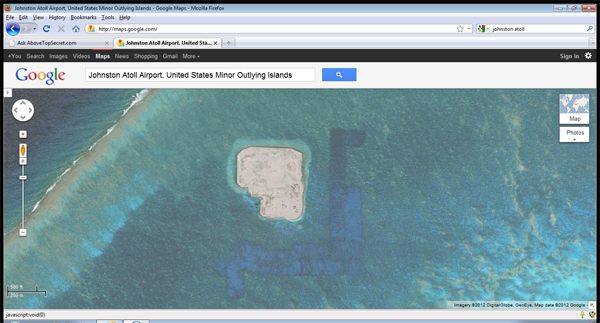
If it had been Photoshopped they'd have gone to a lot more trouble than getting someone with no P/S experience at all to do it.
If it had been Photoshopped they'd have gone to a lot more trouble than getting someone with no P/S experience at all to do it.
edit on
21-1-2012 by Imagewerx because: (no reason given)
This is what it'd look like if it had been Photoshopped,this is about a minutes work with the clone stamp tool....

Floating Heli-pad?... on holidays?
Could be anything really.
Could be anything really.
edit on 21-1-2012 by Qumulys because: (no reason given)
Could be a part of the Pacific SOSUS/IUSS sonar networks. Given that location and it's history, I'd expect to see some oddball stuff in the waters
around it, actually. The tourist attraction that Area 51 has become over the years just has pretty signs people can take pictures of and say they were
there.
A place like this, I'm guessing, has no signs and doesn't give warnings if your in too close. Hence...some weird stuff I'd think is either Sonar related or some other form of security to keep private things truly private.
A place like this, I'm guessing, has no signs and doesn't give warnings if your in too close. Hence...some weird stuff I'd think is either Sonar related or some other form of security to keep private things truly private.
I hope youare not seeing odd white vans parked around your neighbourhood lately Arken.....you may be getting too close.....
This is indeed an interesting place, and it would be nice to get something from fisheries and oceans dept on whats going on out there ....
Shouldnt be a problem right?
OK so whos gonna ask em?
This is indeed an interesting place, and it would be nice to get something from fisheries and oceans dept on whats going on out there ....
Shouldnt be a problem right?
OK so whos gonna ask em?
dredging coral, why would they do that? the atoll is obviously a dirty place and the military have pissed off, Arken may just have hit on something
here, but what?
That's probably where they launched the rockets for the high altitude nuclear tests back in the 50s and 60s.
Originally posted by smurfy
dredging coral, why would they do that? the atoll is obviously a dirty place and the military have pissed off, Arken may just have hit on something here, but what?
They dredged to increase the size of the islands......
familypedia.wikia.com...
It's now nothing more sinister than a nature reserve.
reply to post by Arken
It looks too perfectly made to be a natural formation. I could agree with the lighthouse foundation as it would be a good place for one, but it's almost too perfectly round even for that. There's nothing mysterious about the channel as it could have been made for ships to get in close.
It looks too perfectly made to be a natural formation. I could agree with the lighthouse foundation as it would be a good place for one, but it's almost too perfectly round even for that. There's nothing mysterious about the channel as it could have been made for ships to get in close.
new topics
-
WF Killer Patents & Secret Science Vol. 1 | Free Energy & Anti-Gravity Cover-Ups
General Conspiracies: 21 minutes ago -
Hurt my hip; should I go see a Doctor
General Chit Chat: 1 hours ago -
Israel attacking Iran again.
Middle East Issues: 2 hours ago -
Michigan school district cancels lesson on gender identity and pronouns after backlash
Education and Media: 2 hours ago -
When an Angel gets his or her wings
Religion, Faith, And Theology: 3 hours ago -
Comparing the theology of Paul and Hebrews
Religion, Faith, And Theology: 4 hours ago -
Pentagon acknowledges secret UFO project, the Kona Blue program | Vargas Reports
Aliens and UFOs: 5 hours ago -
Boston Dynamics say Farewell to Atlas
Science & Technology: 5 hours ago -
I hate dreaming
Rant: 5 hours ago -
Man sets himself on fire outside Donald Trump trial
Mainstream News: 7 hours ago
top topics
-
The Democrats Take Control the House - Look what happened while you were sleeping
US Political Madness: 8 hours ago, 18 flags -
In an Historic First, In N Out Burger Permanently Closes a Location
Mainstream News: 10 hours ago, 16 flags -
A man of the people
Medical Issues & Conspiracies: 15 hours ago, 11 flags -
Biden says little kids flip him the bird all the time.
Politicians & People: 7 hours ago, 8 flags -
Man sets himself on fire outside Donald Trump trial
Mainstream News: 7 hours ago, 7 flags -
Pentagon acknowledges secret UFO project, the Kona Blue program | Vargas Reports
Aliens and UFOs: 5 hours ago, 6 flags -
Israel attacking Iran again.
Middle East Issues: 2 hours ago, 5 flags -
Michigan school district cancels lesson on gender identity and pronouns after backlash
Education and Media: 2 hours ago, 4 flags -
4 plans of US elites to defeat Russia
New World Order: 17 hours ago, 4 flags -
Boston Dynamics say Farewell to Atlas
Science & Technology: 5 hours ago, 4 flags
active topics
-
Sheetz facing racial discrimination lawsuit for considering criminal history in hiring
Social Issues and Civil Unrest • 7 • : Caver78 -
Hurt my hip; should I go see a Doctor
General Chit Chat • 9 • : rickymouse -
Silent Moments --In Memory of Beloved Member TDDA
Short Stories • 48 • : Encia22 -
MULTIPLE SKYMASTER MESSAGES GOING OUT
World War Three • 52 • : cherokeetroy -
Israel attacking Iran again.
Middle East Issues • 22 • : Boomer1947 -
WF Killer Patents & Secret Science Vol. 1 | Free Energy & Anti-Gravity Cover-Ups
General Conspiracies • 1 • : WakeofPoseidon -
The Democrats Take Control the House - Look what happened while you were sleeping
US Political Madness • 67 • : WeMustCare -
Thousands Of Young Ukrainian Men Trying To Flee The Country To Avoid Conscription And The War
Other Current Events • 53 • : ghandalf -
Boston Dynamics say Farewell to Atlas
Science & Technology • 5 • : Caver78 -
Biden says little kids flip him the bird all the time.
Politicians & People • 16 • : stelth2