It looks like you're using an Ad Blocker.
Please white-list or disable AboveTopSecret.com in your ad-blocking tool.
Thank you.
Some features of ATS will be disabled while you continue to use an ad-blocker.

New Activity at Mt. Rainier Confirmed to Be Seismic (...or ICE?), Right here on ATS!
page: 1share:
I felt a new thread is warranted, for several reasons:
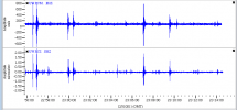
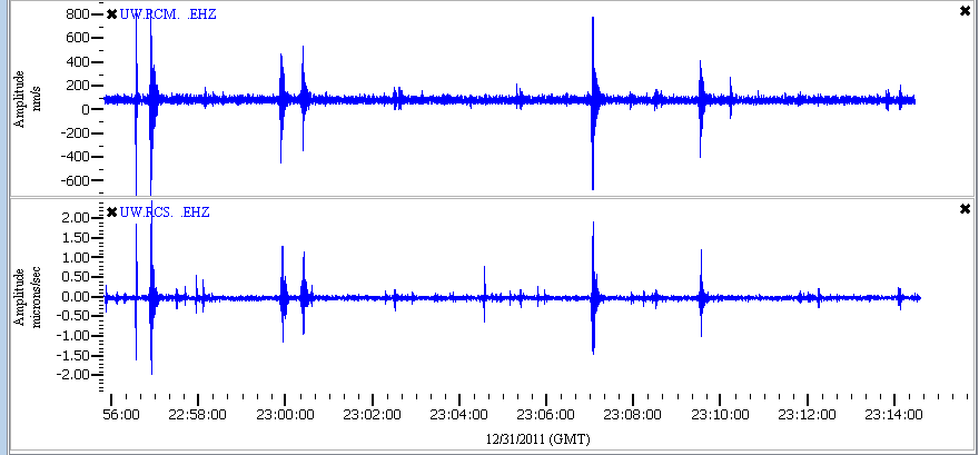
1) Seismic swarms at this volcano merit vigilance. Here is one webicorder at RCS we are watching:
pele.ess.washington.edu:16017...
and here is a GEE readout of two stations:
2) Mount Rainier in Washington is a very dangerous volcano!
en.wikipedia.org...
3) PuterMan, a renown ATS member has analyzed the quakes and has determined they are most likely seismic due to the frequency content:
www.abovetopsecret.com...
This means that we now know, before even the USGS has announced it, that we have a swarm at Rainier. And that is news. This is why ATS rocks!
4) This was discovered recently by ATS member westcoast, who keeps constant watch on the happenings on the "westcoast."
www.abovetopsecret.com...
So we are wondering what this dangerous volcano is going to do next, and ATS members in the area should beware. It is not the first time Ranier has shown activity, and at this point you could say we are watching for any signs of volcanic or harmonic tremor- which can be an indicator of imminent eruption.
1) Seismic swarms at this volcano merit vigilance. Here is one webicorder at RCS we are watching:
pele.ess.washington.edu:16017...
and here is a GEE readout of two stations:
2) Mount Rainier in Washington is a very dangerous volcano!
Mount Rainier[7] is a massive stratovolcano located 54 miles (87 km) southeast of Seattle in the state of Washington, United States. It is the most topographically prominent mountain in the contiguous United States and the Cascade Volcanic Arc, with a summit elevation of 14,411 feet (4,392 m).[1][2] Mt. Rainier is considered one of the most dangerous volcanoes in the world, and it is on the Decade Volcano list.[8] Because of its large amount of glacial ice, Mt. Rainier could potentially produce massive lahars that would threaten the whole Puyallup River valley.[9]
en.wikipedia.org...
3) PuterMan, a renown ATS member has analyzed the quakes and has determined they are most likely seismic due to the frequency content:
www.abovetopsecret.com...
This means that we now know, before even the USGS has announced it, that we have a swarm at Rainier. And that is news. This is why ATS rocks!
4) This was discovered recently by ATS member westcoast, who keeps constant watch on the happenings on the "westcoast."
www.abovetopsecret.com...
So we are wondering what this dangerous volcano is going to do next, and ATS members in the area should beware. It is not the first time Ranier has shown activity, and at this point you could say we are watching for any signs of volcanic or harmonic tremor- which can be an indicator of imminent eruption.
edit on Sat Dec 31st 2011 by TrueAmerican because: (no reason given)
edit on Sat Dec 31st 2011 by TrueAmerican
because: (no reason given)
edit on Sat Dec 31st 2011 by TrueAmerican because: (no reason given)
Good work ATS members.
Will be keeping watch with
you from this thread.
Will be keeping watch with
you from this thread.
reply to post by TrueAmerican
From Smithsonian in Google Earth.
Repeated from an edit on QW 2012
I note that there is little or nothing visible on the next layer of seismos out which would indicate that this is happening on the peak if it is ice or under the peak if seismic.
Mount Rainier, at 4392 m the highest peak in the Cascade Range, forms a dramatic backdrop to the Puget Sound region. Large Holocene mudflows from collapse of this massive, heavily glaciated andesitic volcano have reached as far as the Puget Sound lowlands. The present summit was constructed within a large crater breached to the northeast formed by collapse of the volcano during a major explosive eruption about 5600 years that produced the widespread Osceola Mudflow. Rainier has produced eruptions throughout the Holocene, including about a dozen during the past 2600 years; the largest of these occurred about 2200 years ago. The present-day summit cone is capped by two overlapping craters. Extensive hydrothermal alteration of the upper portion of the volcano has contributed to its structural weakness; an active thermal system has caused periodic melting on flank glaciers and produced an elaborate system of steam caves in the summit icecap. Reported 19th-century eruptions have not left identifiable deposits, but a phreatic eruption may have taken place as recently as 1894.
From Smithsonian in Google Earth.
Repeated from an edit on QW 2012
I note that there is little or nothing visible on the next layer of seismos out which would indicate that this is happening on the peak if it is ice or under the peak if seismic.
Darn...will have to keep an eye on this thread now. My fiance and I were planing on moving up there within the first quarter of 2012. Seattle to be
exact. Don't think this will change are minds but if things get real active then well definitely have to reconsider.
Originally posted by PuterMan
I note that there is little or nothing visible on the next layer of seismos out which would indicate that this is happening on the peak if it is ice or under the peak if seismic.
Either that or they are small enough and deep enough not to be affecting the other seismos in the area like FMW. But if the activity is happening closer to the peak, is that not cause for alarm? We all know what happened when the cork came undone on Mt. St. Helens in 1980.
edit on Sat Dec
31st 2011 by TrueAmerican because: (no reason given)
reply to post by TrueAmerican
TA, you have been looking at these in GEE. What sort of size do you make them?
I am thinking they are sub 1. Nothing is showing on USGS 1+
TA, you have been looking at these in GEE. What sort of size do you make them?
I am thinking they are sub 1. Nothing is showing on USGS 1+
reply to post by PuterMan
All of GEE went out not long after this discovery from wc. And it's still out for me. But from the little I saw, they are microquakes, mostly, and probably not being reported, or only locally. But there are some bigger quakes sigs on RCS between yesterday and today. You not even seeing those?
All of GEE went out not long after this discovery from wc. And it's still out for me. But from the little I saw, they are microquakes, mostly, and probably not being reported, or only locally. But there are some bigger quakes sigs on RCS between yesterday and today. You not even seeing those?
It blows my mind... ATS is sooooo much more beneficial to everyone than facebook is! And you can't even change your status on ATS!
Thanks to Puterman, Westcoast, and TrueAmerican.. keep us posted.
Thanks to Puterman, Westcoast, and TrueAmerican.. keep us posted.
YEA BUDDY! Awesomeness westcoast. And awesome on you for finding and putting it all together. This is why I love ATS, we may not have win after win,
but when we do win. Its a huge boost for everyone here knowing our work is doing good.
reply to post by TrueAmerican
TA, I had to reboot my computer twice, but got GEE back up and running now.
At least the TA stations( my usual ) are up.
I have TAF04D up, and its running now.
TA, I had to reboot my computer twice, but got GEE back up and running now.
At least the TA stations( my usual ) are up.
I have TAF04D up, and its running now.
edit on 31-12-2011 by dragonlover12 because: (no reason given)
Does Gee go out a lot or do you think that is not a coincidence?
If the latter, would mean it's serious enough to want to hide.
They didn't hide past Yellowstone swarms, so......
If the latter, would mean it's serious enough to want to hide.
They didn't hide past Yellowstone swarms, so......
I know this has been posted before, but here is a link to Mt.
Rainier Lahar hazard map. The link also has other pertinent information. I feel it might be best for locals to review this information in light
of the recent activity and the new snow added to the mountain.
ETA: Sorry here's a better link to Rainier info. USGS
A side note: I had a dream last night (induced by Childrens benadrly, I have a cold) that I was working for the USGS ( A dream job for me) and Mt. Rainier was acting up. I was trying to get back to the office to report to my supervisor because the radio wasn't working, but traffic was being weird and I had an intern who was scared.
edit on 31-12-2011 by collietta because: (no reason given)
reply to post by dragonlover12
Yeah, lol, I should follow my own advice and restart GEE.
It appears some of it is back now...
Trying for RCS now, will bbiam.
EDIT: ok, all's back now, got RCS and several other Rainier stations up working... Thanks for that reminder... And sunny, yeah GEE goes out enough to make you mad sometimes.
edit on Sat Dec 31st 2011 by TrueAmerican because: (no reason given)
Very interesting to keep an eye on. Forgive my ignorance, but isn't harmonic waves still seismic only giving a harmonic of the frequency pattern? I
thought all ground shaking was seismic in nature (except for local landslides and the like). I am only asking because I don't know.
Something strange happened here where I live in NE Florida. I was on the laptop and my cable flashed off saying I was not authorized to use this set top box. It gave the number and I pulled out my cell phone and it said something I had never seen a cell phone say. It said "Failed to send Message. Reason Unknown" and was basically locked in that screen. Now one or the other wouldn't suprise me much but both was too odd. Then they both returned to normal operation at the same time about a 20-30 second break in functioning. I thought the next thing was going to be some national emergency broadcast or something. I thought I would mention it here to see if anyone else had any similar oddities with their electronics. BTW, all bills are paid up and have been for the last 20 years with full service. Strange occurences. I will keep an eye on this monster though. Thanks!
Something strange happened here where I live in NE Florida. I was on the laptop and my cable flashed off saying I was not authorized to use this set top box. It gave the number and I pulled out my cell phone and it said something I had never seen a cell phone say. It said "Failed to send Message. Reason Unknown" and was basically locked in that screen. Now one or the other wouldn't suprise me much but both was too odd. Then they both returned to normal operation at the same time about a 20-30 second break in functioning. I thought the next thing was going to be some national emergency broadcast or something. I thought I would mention it here to see if anyone else had any similar oddities with their electronics. BTW, all bills are paid up and have been for the last 20 years with full service. Strange occurences. I will keep an eye on this monster though. Thanks!
edit on 31/12/11 by spirit_horse because: (no reason given)
Thanks TA....I agree it is worth the extra watching. I have seen some similar activity before, hence my other threads, but this is a bit different.
I often see a lot of what looks like micro quakes on RCS...but these are larger and more frequent...the sigs are different. I usually sum most of it
up to ice quakes. I don't think that I have ever seen this many though showing up like this on all three stations.
Here are the links I am using:
PNSN old webis....I still like them best
WEBI2 seismos...new ones
You will want to look at RCS, RCM and STAR
Ugh...first GEE goes down and now it looks like STAR got saturated. Makes me a bit more suspicous.
As to none of these quakes getting listed...yes, they are micro and also remember that not only is it Saturday, but a holiday. These small ones do not register. While you might think there are geologists watching these volcanos around the clock, I have been very surprised by recent emails exchanges to find out that they are NOT and I even gave them info about Glacier peak that they were totally unaware of.
Someone on the other thread mentioned watching Dantes Peak tonight. Anyone curious about what could happen if and when this mountain erupts should watch it. It is basically a documentary on it. (IMO)
Note: other then these odd sigs, there have been NO signs of any kind of pending eruption so please do not take my comments to mean that. I think it warrants extra watching and awareness. Hopefully it will all settle down.
Just watching out for Mt. Pele and Vesuvius. Edgar Cayce has been right on almost every ocassion.
This is the most recent quake listed on Rainier that I could find. Rainier EQ 31 Dec 2011 Mag -0.3
on PNSN.org
Magnitude -0.3? I need someone to explain this, lol. But the depth, at 2.08 miles is interesting.
As an aside, a Happy and Peaceful New Year to All.
Magnitude -0.3? I need someone to explain this, lol. But the depth, at 2.08 miles is interesting.
As an aside, a Happy and Peaceful New Year to All.
reply to post by westcoast
Well one thing seems to be true: that the PNSN has these stations on data delay- or it's taking longer to get the data available at IRIS than most other major networks. Huge gap in GEE.
Well one thing seems to be true: that the PNSN has these stations on data delay- or it's taking longer to get the data available at IRIS than most other major networks. Huge gap in GEE.
edit on Sat Dec 31st 2011 by TrueAmerican because: (no reason given)
reply to post by PuterMan
Also, station STAR is closer to the peak than any, so that makes me wonder if the activity is more on the east side, where RCS is showing it strongest.
Also, station STAR is closer to the peak than any, so that makes me wonder if the activity is more on the east side, where RCS is showing it strongest.
Alaska s Cleveland Volcano has ramped up again....they are along the same plate lines
Connected maybe?
Connected maybe?
new topics
-
University of Texas Instantly Shuts Down Anti Israel Protests
Education and Media: 25 minutes ago -
Any one suspicious of fever promotions events, major investor Goldman Sachs card only.
The Gray Area: 2 hours ago -
God's Righteousness is Greater than Our Wrath
Religion, Faith, And Theology: 7 hours ago -
Electrical tricks for saving money
Education and Media: 10 hours ago -
VP's Secret Service agent brawls with other agents at Andrews
Mainstream News: 11 hours ago
top topics
-
VP's Secret Service agent brawls with other agents at Andrews
Mainstream News: 11 hours ago, 9 flags -
Cats Used as Live Bait to Train Ferocious Pitbulls in Illegal NYC Dogfighting
Social Issues and Civil Unrest: 15 hours ago, 8 flags -
Nearly 70% Of Americans Want Talks To End War In Ukraine
Political Issues: 12 hours ago, 4 flags -
Electrical tricks for saving money
Education and Media: 10 hours ago, 4 flags -
Sunak spinning the sickness figures
Other Current Events: 12 hours ago, 3 flags -
Late Night with the Devil - a really good unusual modern horror film.
Movies: 14 hours ago, 2 flags -
Any one suspicious of fever promotions events, major investor Goldman Sachs card only.
The Gray Area: 2 hours ago, 2 flags -
The Good News According to Jesus - Episode 1
Religion, Faith, And Theology: 17 hours ago, 1 flags -
God's Righteousness is Greater than Our Wrath
Religion, Faith, And Theology: 7 hours ago, 0 flags -
University of Texas Instantly Shuts Down Anti Israel Protests
Education and Media: 25 minutes ago, 0 flags
active topics
-
God's Righteousness is Greater than Our Wrath
Religion, Faith, And Theology • 25 • : andy06shake -
Russia Ukraine Update Thread - part 3
World War Three • 5730 • : Arbitrageur -
Nearly 70% Of Americans Want Talks To End War In Ukraine
Political Issues • 28 • : andy06shake -
VP's Secret Service agent brawls with other agents at Andrews
Mainstream News • 43 • : Hakaiju -
Everest-sized ‘Devil comet’ Pons-Brooks Visible Now
Space Exploration • 17 • : Compendium -
Nakedeye Mother of Dragons Comet Is Here!
Space Exploration • 5 • : Compendium -
HORRIBLE !! Russian Soldier Drinking Own Urine To Survive In Battle
World War Three • 38 • : BernnieJGato -
15 Unhealthiest Sodas On The Market
Health & Wellness • 43 • : JPRCrastney -
University of Texas Instantly Shuts Down Anti Israel Protests
Education and Media • 0 • : FlyersFan -
Sunak spinning the sickness figures
Other Current Events • 9 • : Ohanka