It looks like you're using an Ad Blocker.
Please white-list or disable AboveTopSecret.com in your ad-blocking tool.
Thank you.
Some features of ATS will be disabled while you continue to use an ad-blocker.

Volcano Watch 2012 !
page: 11share:
www.geonet.org.nz...
Tongariro has just been upgraded from level 0 to level 1 - meaning showing signs of volcanic activity after a swarm of eq's starting July 13.
Tongariro has just been upgraded from level 0 to level 1 - meaning showing signs of volcanic activity after a swarm of eq's starting July 13.
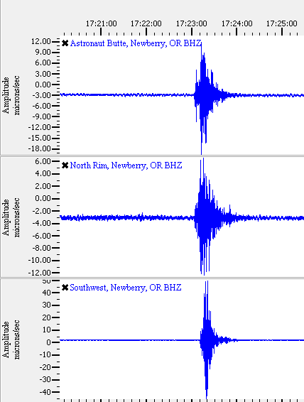
Anyone else notice this small earthquake near Newberry Volcano a few minutes ago?
Iris station SWNB.CC..BHZ
This link is KWBU short period station located approximately 10 km north of SWNB. It looks noisier.
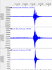
Here is a thumbnail from GEE of CC network broadband stations; SWNB, ASBU and NORM.
It isn't listed on the PNSN recent quakes page or USGS US 'all magnitudes' 7-day page.
Maybe it was a jet......again.
BTW, I realize this earthquake is small, and nothing to get alarmed about. I just like to monitor events near the Cascade volcanoes--you never know when something may develop.
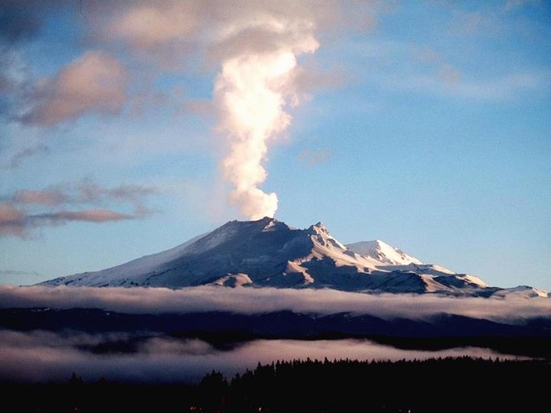
Here is some additional info on Newberry volcano.
Iris station SWNB.CC..BHZ
This link is KWBU short period station located approximately 10 km north of SWNB. It looks noisier.
Here is a thumbnail from GEE of CC network broadband stations; SWNB, ASBU and NORM.
It isn't listed on the PNSN recent quakes page or USGS US 'all magnitudes' 7-day page.
Maybe it was a jet......again.
BTW, I realize this earthquake is small, and nothing to get alarmed about. I just like to monitor events near the Cascade volcanoes--you never know when something may develop.
Here is some additional info on Newberry volcano.
edit on 7/23/2012 by Olivine because: I forgot a forgot the "a" before jet
edit on 7/23/2012 by Olivine because: (no reason
given)
reply to post by Olivine
Just a quick note to say PNSN listed this quake as Mag 2.1 , at the surface, and possible blast/explosion.
Not much happens at Newberry Caldera, and what does, seems to concentrate near the surface. Icequakes from the lakes in the winter, blasting, logging, etc. All is quiet--that's a good thing.
I really wish ATS would let us just edit/add to previous posts...
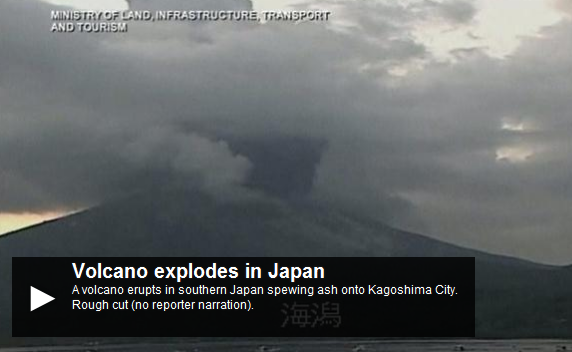
Japanese Volcano erupts, caught on camera awesome shockwave
www.abovetopsecret.com...
by Agit8dChop
started on 7/26/2012 @ 01:51 AM
Yikes.
www.abovetopsecret.com...
by Agit8dChop
started on 7/26/2012 @ 01:51 AM
Originally posted by Agit8dChop
www.news.com.au...
The volcano is spewing ash onto Kagoshima City in southern Japan, with residents forced to walk and drive through thick clouds of ash.
The eruption was filmed live from a number of angles, with the moment of explosion looking eerily like a huge bomb.
that has some power behind it..
Yikes.
www.news.com.au...
edit on 7/26/2012 by this_is_who_we_are because: photo
I've been checking on El Hierro every few days since the most recent swarm of activity ended early this month.
Recent earthquake activity has slowed dramatically, with only 32
earthquakes during the past 2 weeks.
The seismogr ams are quiet.
What I found strange is the deformation. The GPS data had not been updated for a few days, and I expected to see some subsidence when the data was refreshed. Not the case.
All of the stations seem to be holding fairly steady, and at least four (HI03, HI08, HI09, & HI10) are still showing vertical gains over the past 1-2 days.
It appears that the island is not finished just yet.
Earthquake-report.com has more in-depth commentary.
edit on 7/27/2012 by Olivine because: correction
Crater Lake at White Island has recently started to re-fill and gases are now vigorously streaming through it. Airborne gas measurements made yesterday show that the discharge of some sulphur gases has increased. During the past few weeks there has also been some minor volcanic tremor.
more
Alert level has alays been 1, its the Aviation level that has changed.
at the bottom they say
The increased activity at White Island has no connection with the recent earthquakes and changes in gas flux at Tongariro volcano
however IMO it may be the result of the recent activity on the East Cape Ridge, swarms of 4's and 5's for over a week. quaketrails.wordpress.com...
reply to post by muzzy
I have certainly noticed the change of activity at White Island via the web cameras with more steam plumes today. Quite a different picture from last week!
White Island - cameras
I have certainly noticed the change of activity at White Island via the web cameras with more steam plumes today. Quite a different picture from last week!
White Island - cameras
reply to post by slidingdoor
Thanks for posting this. I hope they find everyone safe.
Here is a link to the seismograph at West Tongariro.
The webcam looks dark and covered with rain, ash or some other debris, but here is the link.
Thanks for posting this. I hope they find everyone safe.
Here is a link to the seismograph at West Tongariro.
The webcam looks dark and covered with rain, ash or some other debris, but here is the link.
wow
ashfall prediction map
Aviation level at Red
ashfall prediction map
Aviation level at Red
edit on 6-8-2012 by muzzy because: (no reason given)
wow wow
2 volcanos at Level 2 alert (Minor eruptive activity) at the same time -
White Island page on Geonet
Aviation Alert Level Orange
2 volcanos at Level 2 alert (Minor eruptive activity) at the same time -
White Island page on Geonet
Aviation Alert Level Orange
reply to post by muzzy
Damm scarey stuff Muzzy, looks like I might be 'a running for the hills' very shortly!! We had a small amount of ash particles in the air, could see it through the glaze of the sun this morning. Hopefully if White Island (Whakaari) does erupt again it won't cause a tsunami.
Damm scarey stuff Muzzy, looks like I might be 'a running for the hills' very shortly!! We had a small amount of ash particles in the air, could see it through the glaze of the sun this morning. Hopefully if White Island (Whakaari) does erupt again it won't cause a tsunami.
Originally posted by muzzy
wow
wow indeed
I've been excited all morning after hearing the news, waiting for more information to come out regarding the eruption. I have fond memories of witnessing the 95/96 eruption of Ruapehu, as I was living in Taupo at the time, and I still have family in the area.
From what I gather, the recent eruption is venting from the Te Maari craters, which last erupted in 1897. This was the most recent eruption at Tongariro if you regard Ngaruhoe as a separate volcano, although you could arguably claim that Ngaruhoe is one of the vents of the Tongariro complex. Here is a pdf of the volcanic hazards at Tongariro for those interested. Volcanic Hazards at Tongariro
Also, I've come across this image that was taken this morning.
It will be interesting to see how this eruption unfolds (same goes for White Island, but I find Tongariro a little more exciting). But I hope everyone close to the mountain remains safe.
Also just came across some raw video from the eruption late last night. It's a bit hard to make out what is going on, but still pretty
interesting.
Raw Video
So far the eruption has been classified as a hydrothermal eruption, with an ash cloud produced. It's impossible to tell exactly how the eruption will play out from here. We could see activity start to drop, or we could see ongoing activity with the potential for more violent magmatic eruptions. Fingers crossed that no one gets hurt, but I can't help but be a little bit excited that we're getting another eruption
@muzzy
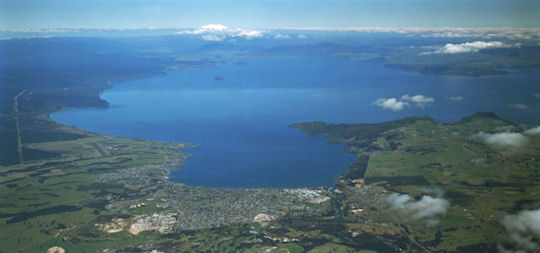
Is that Lake Taupo just above the erupting volcano of yours?
Just wondering.
Nidwin
Is that Lake Taupo just above the erupting volcano of yours?
Just wondering.
Nidwin
Originally posted by Nidwin
@muzzy
Is that Lake Taupo just above the erupting volcano of yours?
Just wondering.
Nidwin
Yep thats the mother of the group alright.
in this (Geonet) image you can see Tongariro across the Taupo caldera lake (photo taken from above the town of Taupo at the north end of the lake)
What struck me about this is on the TV News they interviewed a few locals who live nearby on the shores of Lake Rotoaira and they said they saw redness inside the plume of "hydro thermal ash" so I can't see how its a purely a hydro (water) eruption, there has to be lava involved if there was redness .......
Some of these folks have moved to the local Marae for safety.
reply to post by Curious and Concerned
best picture I've seen of the eruption yet, the TV coverage has been useless exxcept for flyovers showing everything in almost black and white. Its probably the rain that's stifling good picture taking.
That image almost looks like CGI, wheres the rain and clouds?
best picture I've seen of the eruption yet, the TV coverage has been useless exxcept for flyovers showing everything in almost black and white. Its probably the rain that's stifling good picture taking.
That image almost looks like CGI, wheres the rain and clouds?
Originally posted by muzzy
reply to post by Curious and Concerned
best picture I've seen of the eruption yet, the TV coverage has been useless exxcept for flyovers showing everything in almost black and white. Its probably the rain that's stifling good picture taking.
That image almost looks like CGI, wheres the rain and clouds?
Apparently there were some clear patches in the morning, as I've seen a few photos showing relatively clear skies. Those mountains can do some strange things to the local weather though. Here is one of them taken yesterday morning.
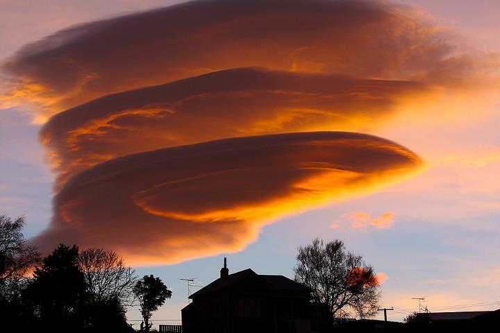
I also believe the media coverage has been rather poor. Some news sites have shown similar photos to that above and called it an ash cloud, when it is actually a classic lenticular cloud formation over Ruapehu, known to some locals as the Rangataua Pet. I've also found it strange that some news sites are reporting that an eruption was "unexpected". An eruption wasn't guaranteed, but it wasn't completely unexpected either. The volcanic alert level had just been raised, after all.
I'm also a little confused as to how this was just a "hydrothermal" eruption. Many witness accounts seem to see some brightness within the plume, and I'm not sure how a purely "hydrothermal" eruption would create such a spectacle.
reply to post by Curious and Concerned
that image isn't of this eruption - sorry! But don't worry - every one has been posting that pic around including the media! What a huge media fail there!
that image isn't of this eruption - sorry! But don't worry - every one has been posting that pic around including the media! What a huge media fail there!
Originally posted by Evltre
reply to post by Curious and Concerned
that image isn't of this eruption - sorry! But don't worry - every one has been posting that pic around including the media! What a huge media fail there!
Thanks for confirming that, didn't look like the picture fitted the facts, The 'ruption was just before midnight and only lasted 10 minutes, so there wouldn't have been a steam cloud that size in the morning eh.
Thats probably why there are no real pictures of the eruption.You would have thought someone would have got something on a cellphone at least, even if youre on welfare you have to have a cell phone to be contactable 99% of cellphone have a camera.
That image looks like the tailend of the 1995 eruption taken from the the Rotoaira side of Tongariro, the plume from this one should be in the right hand side forefront of the first slope, Te Maari crater
new topics
-
God's Righteousness is Greater than Our Wrath
Religion, Faith, And Theology: 3 hours ago -
Electrical tricks for saving money
Education and Media: 6 hours ago -
VP's Secret Service agent brawls with other agents at Andrews
Mainstream News: 8 hours ago -
Sunak spinning the sickness figures
Other Current Events: 8 hours ago -
Nearly 70% Of Americans Want Talks To End War In Ukraine
Political Issues: 9 hours ago -
Late Night with the Devil - a really good unusual modern horror film.
Movies: 10 hours ago
top topics
-
VP's Secret Service agent brawls with other agents at Andrews
Mainstream News: 8 hours ago, 9 flags -
Cats Used as Live Bait to Train Ferocious Pitbulls in Illegal NYC Dogfighting
Social Issues and Civil Unrest: 12 hours ago, 8 flags -
Electrical tricks for saving money
Education and Media: 6 hours ago, 4 flags -
HORRIBLE !! Russian Soldier Drinking Own Urine To Survive In Battle
World War Three: 16 hours ago, 3 flags -
Nearly 70% Of Americans Want Talks To End War In Ukraine
Political Issues: 9 hours ago, 3 flags -
Sunak spinning the sickness figures
Other Current Events: 8 hours ago, 3 flags -
Late Night with the Devil - a really good unusual modern horror film.
Movies: 10 hours ago, 2 flags -
The Good News According to Jesus - Episode 1
Religion, Faith, And Theology: 14 hours ago, 1 flags -
God's Righteousness is Greater than Our Wrath
Religion, Faith, And Theology: 3 hours ago, 0 flags
active topics
-
How ageing is" immune deficiency"
Medical Issues & Conspiracies • 34 • : angelchemuel -
Nearly 70% Of Americans Want Talks To End War In Ukraine
Political Issues • 13 • : Freeborn -
Mood Music Part VI
Music • 3101 • : ThatSmellsStrange -
VP's Secret Service agent brawls with other agents at Andrews
Mainstream News • 41 • : ThatSmellsStrange -
HORRIBLE !! Russian Soldier Drinking Own Urine To Survive In Battle
World War Three • 32 • : DaRAGE -
New whistleblower Jason Sands speaks on Twitter Spaces last night.
Aliens and UFOs • 55 • : baablacksheep1 -
Cats Used as Live Bait to Train Ferocious Pitbulls in Illegal NYC Dogfighting
Social Issues and Civil Unrest • 20 • : Asher47 -
Electrical tricks for saving money
Education and Media • 4 • : Lumenari -
DONALD J. TRUMP - 2024 Candidate for President - His Communications to Americans and the World.
2024 Elections • 514 • : WeMustCare -
The Acronym Game .. Pt.3
General Chit Chat • 7744 • : bally001