It looks like you're using an Ad Blocker.
Please white-list or disable AboveTopSecret.com in your ad-blocking tool.
Thank you.
Some features of ATS will be disabled while you continue to use an ad-blocker.

Quake Watch 2012
page: 9share:
reply to post by muzzy
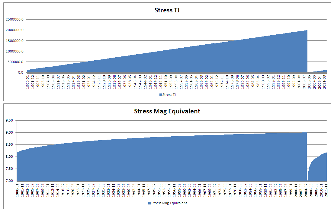
In that particular instance the energy is just the energy of the mag 6.6 as I have not looked at other figures for SCI yet (I don't think there is much though)
The stress level in TJ is a simple progression where the current level is incremented by the 'Periodic Energy'. This figure is normally the total energy released in the period 1900 to 2011 divided by the number of months. The periodic energy for SCI appears to be about 103 TJ per month which is roughly the amount of energy as a Mag 6.3. Periodic energy may not always be that value as the aim is to 'zero' the data on the largest event. If for example I knew there was a mag 9 in 1850 then I would try and reconstruct a current stress energy taking that event as the potential of the area and assuming total stress release at that point.
Removed from this is the aggregate energy for the month, thus if the aggregate energy is < 103 TJ there will be an increase in energy and > 103 will lead to a decrease. The effects of the logarithmic scale are very marked such that the 6.6 today made pretty much no discernible difference to the current stress levels.
If you look at the section of 2011 I have extracted you will see how it works.
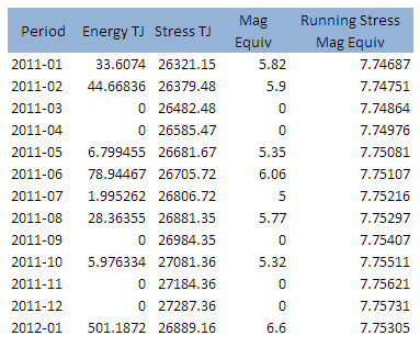
If you look at June you can see that the events for the month did not reduce the over all figure despite being the equivalent of a mag 6 whereas today's event did just reduce the figure as it was 5 times the monthly value BUT it hardly scratched the magnitude equivalent of the stress only dropping it from 7.757 to 7.753 even though that is a difference of 501 TJ of energy.
Obviously it is not a highly accurate tool as data for the earlier years is sparse, but where an area is capable of mag 6.5 plus quakes it should be reasonable. Once I have all the base values then I can start later graphs from a know point and make them easier to see what is going on with less data squashed in.
In that particular instance the energy is just the energy of the mag 6.6 as I have not looked at other figures for SCI yet (I don't think there is much though)
The stress level in TJ is a simple progression where the current level is incremented by the 'Periodic Energy'. This figure is normally the total energy released in the period 1900 to 2011 divided by the number of months. The periodic energy for SCI appears to be about 103 TJ per month which is roughly the amount of energy as a Mag 6.3. Periodic energy may not always be that value as the aim is to 'zero' the data on the largest event. If for example I knew there was a mag 9 in 1850 then I would try and reconstruct a current stress energy taking that event as the potential of the area and assuming total stress release at that point.
Removed from this is the aggregate energy for the month, thus if the aggregate energy is < 103 TJ there will be an increase in energy and > 103 will lead to a decrease. The effects of the logarithmic scale are very marked such that the 6.6 today made pretty much no discernible difference to the current stress levels.
If you look at the section of 2011 I have extracted you will see how it works.
If you look at June you can see that the events for the month did not reduce the over all figure despite being the equivalent of a mag 6 whereas today's event did just reduce the figure as it was 5 times the monthly value BUT it hardly scratched the magnitude equivalent of the stress only dropping it from 7.757 to 7.753 even though that is a difference of 501 TJ of energy.
Obviously it is not a highly accurate tool as data for the earlier years is sparse, but where an area is capable of mag 6.5 plus quakes it should be reasonable. Once I have all the base values then I can start later graphs from a know point and make them easier to see what is going on with less data squashed in.
Magnitude mb 5.2
Region SOUTHERN IRAN
Date time 2012-01-09 19:53:41.0 UTC
Location 27.24 N ; 55.63 E
Depth 40 km
Distances 61 km W Bandar-e 'abbas (pop 317,946 ; local time 23:23:41.7 2012-01-09)
65 km NW Qeshm (pop 16,691 ; local time 23:53:41.7 2012-01-09)
EMSC
with Photo and graphic
A seismic shift in Ohio’s concerns over earthquakes
A little-known state office managed by a seismologist working part time has become the epicenter of an investigation garnering international attention
By Spencer Hunt
The Columbus Dispatch Monday January 9, 2012 6:10 AM
www.dispatch.com/content/stories/local/2012/01/09/a-seismic-shift.html
DELAWARE, Ohio — Most people likely had never heard of the Ohio Seismic Network or the state office over it, the Ohio Geological Survey.
Until New Year’s Eve, when a magnitude 4.0 quake shook Youngstown.
“All of a sudden, the Geological Survey has risen from a totally obscure agency to something where people know who we are,” said Michael Hansen, state seismologist.
Hansen pretty much is the seismic network. The part-time state employee keeps watch over 26 earthquake detectors with an annual budget of $20,000.
After the New Year’s Eve quake, his quiet office in a lab building near the city of Delaware has become the epicenter of an investigation into a string of earthquakes in the Youngstown area that’s drawn international attention.
(...)
reply to post by PuterMan
Seems I have exceeded the 4 hour window of 2 hours to edit the post
Just wanted to add that Iran have it as 5.0 ML
IIEES
(Please let me know if that link does not work as they have changed the site and that may be a session address.)
EMSC actually had it displayed long before them!
Seems I have exceeded the 4 hour window of 2 hours to edit the post
Just wanted to add that Iran have it as 5.0 ML
IIEES
(Please let me know if that link does not work as they have changed the site and that may be a session address.)
EMSC actually had it displayed long before them!
reply to post by PuterMan
I'm just waiting for any 'shallow' quakes to hit Iran in the very near future, and see if the data supports a normal quake or possible NUKE strike!
I'm just waiting for any 'shallow' quakes to hit Iran in the very near future, and see if the data supports a normal quake or possible NUKE strike!
Bloomberg reports on the news that integration of the Massive Ordnance Penetrator (MOP) onto the B-2 "Spirit" stealth bomber has finally been achieved. In fact the US airforce had revealed this at the end of September during a lengthy speech by a general, but nobody (except, perhaps, Iranian military intelligence) particularly noticed until now.
The MOP is a 14-tonne (15 short ton) pencil of heavy steel, containing a heavy explosive charge of 2.5 tonnes. Dropped from a B-2 cruising above 40,000 feet, it hurtles down to strike its target at supersonic speed, punching through many metres of hardened concrete or other overhead protection before exploding. It was specifically developed for the purpose of destroying WMD facilities at the behest of the US Defense Threat Reduction Agency (DTRA), tasked with keeping America safe from such things as foreign nukes.
here's to 2012, hope it is a slow year for earthquakes! time will tell!
Originally posted by research100
here's to 2012, hope it is a slow year for earthquakes! time will tell!
Nah, not me.....lookin for a lil rockin a rollin for 2012
Originally posted by muzzy
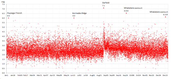
just added another NZ graph to the end of QuakeWatch2011
*this is just a thumbnail to tease, the full size image is linked to on the 2011 Reply
Not sure if its the incomplete data for the last 2 months or what, but the graph shows an overall upward trend in the magnitudes of NZ earthquakes (less low 2's, more 3's and 4's) since the Sumner quake of July 13th.
Note this is ALL of New Zealand, not just Canterbury.

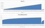
Just did one for 2010, still hard to tell if there is a tendency for overall magnitude rise toward the end of 2011.
2010 only has the 7.1 Darfield quake on land to work with, all the other 6's were offshore, so the bottom line doesn't heave up like after the Atiamuri, Tihoi and Christchurch 6's on land in 2011.
But it sure does heave up for the 7.1 doesn't it!, basically lifted the whole magnitude centre line (thick red part) for about 2 months you can almost see the ground lifting up on the graph
full size > 2010 NZ Timeline Graph
edit on 9-1-2012 by muzzy because:
(no reason given)
Haven't seen this one posted
Magnitude ML 4.6
Region DJIBOUTI
Date time 2012-01-10 04:11:24.0 UTC
Location 11.86 N ; 43.02 E
Depth 4 km
Distances 36 km NW Jibuti (pop 623,891 ; local time 07:11:24.8 2012-01-10)
16 km NE Tajurah (pop 22,193 ; local time 07:11:24.8 2012-01-10)
Source parameters provided by another agency
EMSC
Rainbows
Jane
Right above the Strait of Hormuz
earthquake.usgs.gov...
Magnitude
5.2
Date-Time
Monday, January 09, 2012 at 19:53:37 UTC
Monday, January 09, 2012 at 11:23:37 PM at epicenter
Time of Earthquake in other Time Zones
Location
27.135°N, 55.603°E
Depth
15 km (9.3 miles)
Region
SOUTHERN IRAN
Distances
71 km (44 miles) WSW of Bandar `Abbas, Iran
87 km (54 miles) NE of Bandar-e Lengeh, Iran
113 km (70 miles) NW of Al Khasab, Oman
1036 km (643 miles) SSE of TEHRAN, Iran
Location Uncertainty
horizontal +/- 15.5 km (9.6 miles); depth +/- 2.9 km (1.8 miles)
Parameters
NST=106, Nph=107, Dmin=250.5 km, Rmss=0.91 sec, Gp= 68°,
M-type=body wave magnitude (Mb), Version=9
Source
Magnitude: USGS NEIC (WDCS-D)
Location: USGS NEIC (WDCS-D)
Event ID
usc0007hzx
earthquake.usgs.gov...
Why is my email full of news about fracking causing quakes?
Last year, all I heard was denials and dismissive name calling. Right now, my elected leaders are calling me a radical because I dare to oppose them. So. I guess I'm a radical eco-nut. I was teased relentlessly as a kid. Long ago, I learned how to embrace the name and make it my own. "Sticks and stones may break my bones...."
No wonder I'm a radical loner. Who wants to join a club that thinks tarsands, firey water, spills, and earthquakes, are positives which make for a better civilization?
Not me.
www.washingtonpost.com...
www.cbsnews.com...
www.wfmj.com...
www.usgs.gov...
www.dispatch.com...
www.dailypress.com...
www.washingtonpost.com...
www.telegraph.co.uk...
www.tribtoday.com...
www.inforum.com...
www.wfmj.com...
www.wfmj.com...
www.wytv.com...
www.wytv.com...
www.indystar.com...
And don't forget to catch the propoganda on the Discovery Channel tonight at 10pm.
Licence To Drill
Get it? It's a a play on words. They've changed kill to drill. Actually, I don't really think there's a difference.
I am in a mood to fight. So, I went searching for one. Searched fracking earthquakes on Gooogle. My rage is a hot coal smothered by ashes. But the heat still circulates within the ember.
www.forbes.com...
www.farmanddairy.com...
voices.idahostatesman.com...
news.discovery.com...
www.scientificamerican.com...
www.desmogblog.com...
www.watershedsentinel.ca...
royaldutchshellplc.com...
maddowblog.msnbc.msn.com...
www.dailyfinance.com...
www.youtube.com...
rt.com...
www.whiteoutpress.com...
www.theonion.com...
www.huffingtonpost.com...
www.earth-issues.com...
www.bloomberg.com...
www.thedenverchannel.com...
www.guardian.co.uk...
Don't blame me. I just opened the closet door and they all coming crashing down on my head. Oh, wardrobe for you Brits. I would seem that the main stream press is awake now. Where were they a year ago when we here knew what was happeing.
edit on 10-1-2012 by ericblair4891 because: (no reason given)
Good Post Blair.........
Are all these 5+ quakes north and east of Australia a normal week at the office?
Are all these 5+ quakes north and east of Australia a normal week at the office?
earthquake.usgs.gov...
No tsunami warning yet.
EMSC have just lifted this from 7.1 to 7.5 (both Mw)
www.emsc-csem.org...
Tsunami bulletin now in
Magnitude 7.3 (Preliminary magnitude — update expected within 15 minutes)
Date-Time
Tuesday, January 10, 2012 at 18:37:00 UTC
Wednesday, January 11, 2012 at 12:37:00 AM at epicenter
Location 2.286°N, 93.096°E
Depth 33 km (20.5 miles) set by location program
Region OFF THE WEST COAST OF NORTHERN SUMATRA
Distances
435 km (270 miles) SW (215°) from Banda Aceh, Sumatra, Indonesia
960 km (597 miles) W (265°) from KUALA LUMPUR, Malaysia
Location Uncertainty Error estimate not available
Parameters NST= 8, Nph=0, Dmin=0 km, Rmss=0 sec, Gp=166°,
M-type="moment" magnitude from initial P wave (tsuboi method) (Mi/Mwp), Version=B
Source
NOAA Pacific Tsunami Warning Center
Event ID pt12010000
edit on 10/1/2012 by PuterMan because: (no reason given)
No tsunami warning yet.
edit on 10/1/2012 by PuterMan because: (no reason given)
EMSC have just lifted this from 7.1 to 7.5 (both Mw)
www.emsc-csem.org...
edit on 10/1/2012 by PuterMan because: (no reason given)
Tsunami bulletin now in
000
WEIO23 PHEB 101845
TIBIOX
TSUNAMI BULLETIN NUMBER 001
PACIFIC TSUNAMI WARNING CENTER/NOAA/NWS
ISSUED AT 1845Z 10 JAN 2012
THIS BULLETIN IS FOR ALL AREAS OF THE INDIAN OCEAN.
... TSUNAMI INFORMATION BULLETIN ...
THIS MESSAGE IS FOR INFORMATION ONLY.
THIS BULLETIN IS ISSUED AS ADVICE TO GOVERNMENT AGENCIES. ONLY
NATIONAL AND LOCAL GOVERNMENT AGENCIES HAVE THE AUTHORITY TO MAKE
DECISIONS REGARDING THE OFFICIAL STATE OF ALERT IN THEIR AREA AND
ANY ACTIONS TO BE TAKEN IN RESPONSE.
AN EARTHQUAKE HAS OCCURRED WITH THESE PRELIMINARY PARAMETERS
ORIGIN TIME - 1837Z 10 JAN 2012
COORDINATES - 2.3 NORTH 93.1 EAST
LOCATION - OFF W COAST OF NORTHERN SUMATRA
MAGNITUDE - 7.3
EVALUATION
A DESTRUCTIVE WIDESPREAD TSUNAMI THREAT DOES NOT EXIST BASED ON
HISTORICAL EARTHQUAKE AND TSUNAMI DATA.
HOWEVER - THERE IS A VERY SMALL POSSIBILITY OF A LOCAL TSUNAMI
THAT COULD AFFECT COASTS LOCATED USUALLY NO MORE THAN A HUNDRED
KILOMETERS FROM THE EARTHQUAKE EPICENTER. AUTHORITIES IN THE
REGION NEAR THE EPICENTER SHOULD BE MADE AWARE OF THIS
POSSIBILITY.
THIS WILL BE THE ONLY BULLETIN ISSUED BY THE PACIFIC TSUNAMI
WARNING CENTER FOR THIS EVENT UNLESS ADDITIONAL INFORMATION
BECOMES AVAILABLE.
THE JAPAN METEOROLOGICAL AGENCY MAY ISSUE ADDITIONAL INFORMATION
FOR THIS EVENT. IN THE CASE OF CONFLICTING INFORMATION...THE
MORE CONSERVATIVE INFORMATION SHOULD BE USED FOR SAFETY.
edit on 10/1/2012 by PuterMan because: (no reason given)
reply to post by PuterMan
OHOH....Don't think it was that "Bad Moon Rising" do you?
Will be watching your updates
Rainbows especially to those in Sumatra
Jane
OHOH....Don't think it was that "Bad Moon Rising" do you?
Will be watching your updates
Rainbows especially to those in Sumatra
Jane
No threat of a Pacific-wide tsunami; no tsunami warnings in effect at this time. No word yet on a local
Indonesian government issues tsunami warning following 7.6-magnitude earthquake off Sumatra.
Indonesian government issues tsunami warning following 7.6-magnitude earthquake off Sumatra.
edit on 10-1-2012 by asala because: (no reason
given)
Hey fellow Quake watchers. ;D
I took a break from this site...I have been lurking though.
Anyways... I wanted to give a big bump-in hug to you guys so that I may return here without the search bar.
Peace and love,
Jenn
I took a break from this site...I have been lurking though.
Anyways... I wanted to give a big bump-in hug to you guys so that I may return here without the search bar.
Peace and love,
Jenn
Just a quickly knocked up graph. Don't forget this was the area of Banda Aceh so is capable of a 9. This was a small one for the region.
Looks as if the region still has an 8.1 or so capability. That one hardly scratched the surface.
ETA:
There was a 7.6 here in 2009 and 7.7 in 2010
Looks as if the region still has an 8.1 or so capability. That one hardly scratched the surface.
ETA:
There was a 7.6 here in 2009 and 7.7 in 2010
Date/Time UTC,Latitude,Longitude,Magnitude,Depth(Km),Location
2012-01-10 18:37:01, 2.396, 93.175, 7.3, 29.1, Off W. Coast Of Northern Sumatra
2010-05-09 05:59:42, 3.747, 96.012, 7.2, 45.0, Northern Sumatra. Ind.
2010-04-06 22:15:02, 2.360, 97.131, 7.7, 31.0, Northern Sumatra. Ind.
2009-09-30 10:16:09, -0.725, 99.856, 7.6, 81.0, Southern Sumatra. Ind.
edit on 10/1/2012 by PuterMan because: (no reason given)
new topics
-
George Knapp AMA on DI
Area 51 and other Facilities: 3 hours ago -
Not Aliens but a Nazi Occult Inspired and then Science Rendered Design.
Aliens and UFOs: 3 hours ago -
Louisiana Lawmakers Seek to Limit Public Access to Government Records
Political Issues: 5 hours ago -
The Tories may be wiped out after the Election - Serves them Right
Regional Politics: 6 hours ago -
So I saw about 30 UFOs in formation last night.
Aliens and UFOs: 8 hours ago -
Do we live in a simulation similar to The Matrix 1999?
ATS Skunk Works: 9 hours ago -
BREAKING: O’Keefe Media Uncovers who is really running the White House
US Political Madness: 10 hours ago -
Biden--My Uncle Was Eaten By Cannibals
US Political Madness: 11 hours ago -
"We're All Hamas" Heard at Columbia University Protests
Social Issues and Civil Unrest: 11 hours ago
top topics
-
BREAKING: O’Keefe Media Uncovers who is really running the White House
US Political Madness: 10 hours ago, 23 flags -
Biden--My Uncle Was Eaten By Cannibals
US Political Madness: 11 hours ago, 18 flags -
George Knapp AMA on DI
Area 51 and other Facilities: 3 hours ago, 16 flags -
African "Newcomers" Tell NYC They Don't Like the Free Food or Shelter They've Been Given
Social Issues and Civil Unrest: 16 hours ago, 12 flags -
Russia Flooding
Fragile Earth: 17 hours ago, 7 flags -
"We're All Hamas" Heard at Columbia University Protests
Social Issues and Civil Unrest: 11 hours ago, 7 flags -
Russian intelligence officer: explosions at defense factories in the USA and Wales may be sabotage
Weaponry: 15 hours ago, 6 flags -
Louisiana Lawmakers Seek to Limit Public Access to Government Records
Political Issues: 5 hours ago, 6 flags -
So I saw about 30 UFOs in formation last night.
Aliens and UFOs: 8 hours ago, 5 flags -
The Tories may be wiped out after the Election - Serves them Right
Regional Politics: 6 hours ago, 3 flags
active topics
-
Candidate TRUMP Now Has Crazy Judge JUAN MERCHAN After Him - The Stormy Daniels Hush-Money Case.
Political Conspiracies • 365 • : xuenchen -
"We're All Hamas" Heard at Columbia University Protests
Social Issues and Civil Unrest • 125 • : KrustyKrab -
MULTIPLE SKYMASTER MESSAGES GOING OUT
World War Three • 30 • : Astrocometus -
Biden--My Uncle Was Eaten By Cannibals
US Political Madness • 40 • : Kaiju666 -
Alabama Man Detonated Explosive Device Outside of the State Attorney General’s Office
Social Issues and Civil Unrest • 57 • : watchitburn -
Not Aliens but a Nazi Occult Inspired and then Science Rendered Design.
Aliens and UFOs • 6 • : visitedbythem -
Russian intelligence officer: explosions at defense factories in the USA and Wales may be sabotage
Weaponry • 165 • : andy06shake -
The Tories may be wiped out after the Election - Serves them Right
Regional Politics • 18 • : alldaylong -
Silent Moments --In Memory of Beloved Member TDDA
Short Stories • 43 • : Naftalin -
What do you do to get to sleep and stay asleep ??
Health & Wellness • 108 • : TheGoondockSaint