It looks like you're using an Ad Blocker.
Please white-list or disable AboveTopSecret.com in your ad-blocking tool.
Thank you.
Some features of ATS will be disabled while you continue to use an ad-blocker.

Quake Watch 2012
page: 85share:
I find it highly interesting that the S. American and most recent Japan quake have the EXACT same depth.
Hmmm................go figure.
Hmmm................go figure.
Looks like there was a 3.0 in Virginia according to the Global Incident map. Seems like a lot of quakes but just started following them. Is it normal
or for a better word not uncommon or out of the ordinary to have so many quakes in one day?
reply to post by berkeleygal
good post.
im new to this.
what might want to cause this bounce in mag? at about 75-80 km out?
earthquake.usgs.gov... x.html
im guessing density change in the ground.
think i figured it out.
it was water. the potomac i do believe.
thats the google earth ruler. 80 km on the dot.
good post.
im new to this.
what might want to cause this bounce in mag? at about 75-80 km out?
earthquake.usgs.gov... x.html
im guessing density change in the ground.
edit on 25-3-2012 by omegacorps because: (no reason given)
think i figured it out.
it was water. the potomac i do believe.
thats the google earth ruler. 80 km on the dot.
edit on 26-3-2012 by omegacorps because: (no reason given)
Originally posted by lithegrace
Looks like there was a 3.0 in Virginia according to the Global Incident map. Seems like a lot of quakes but just started following them. Is it normal or for a better word not uncommon or out of the ordinary to have so many quakes in one day?
It looks normal. I see 230 total on the global USGS map.
Usually it's a bit lower than that, but I don't see too much activity as opposed to the norm. The Ring of Fire has definitely been active, though. That Alaska area appears overdue.
I'm a bit worried about the area near the Aleutian trench and the general zone near Central American - Mexico for the next megaquake. Realistically BC-CA is a worry, but I'm a bit focused on the other two areas at present for some reason.
This is my first post here. I've been following seismic activity on my own for a few years, and I was an avid listener in class whenever plate tectonics would come up.
reply to post by PuterMan
Thanks.
I went back on the address (deleting the end part and got to the ftp page itself), geez there are some interesting things on there. hazards.cr.usgs.gov...
Thanks.
I went back on the address (deleting the end part and got to the ftp page itself), geez there are some interesting things on there. hazards.cr.usgs.gov...
reply to post by PuterMan
You got me stumped on that Fiji one.
The only thing I can think of is that its too far north for SNZO.
South of Fiji shows up really well , but not so sure about way up there, its off the main Australian Plate.
You got me stumped on that Fiji one.
The only thing I can think of is that its too far north for SNZO.
South of Fiji shows up really well , but not so sure about way up there, its off the main Australian Plate.
Unless I am wrong, but have there been any aftershocks since the 7.2m Chile quake today? None are showing up on the Live Earthquakes map, but if there
are any on the more localized maps, can anyone confirm?
It just seems odd to have such a large quake with no aftershocks - if there are none.
I could be wrong.
It just seems odd to have such a large quake with no aftershocks - if there are none.
I could be wrong.
edit on 26-3-2012 by Lionhearte because: (no reason given)
reply to post by berkeleygal
We are 29 miles from epicenter of this one, but I missed it because of earplugs & cold medicine! I'd gone to sleep around 10:30 last night, after getting caught up on some threads here. My husband always teases me about reading the forum, & my earthquake apps, but he came upstairs immediately after it happened telling me to check my phone...he was watching Band of Brothers, and at first thought the loud sound was from that, then felt the shaking. He said it lasted roughly 20 seconds or so.
We are 29 miles from epicenter of this one, but I missed it because of earplugs & cold medicine! I'd gone to sleep around 10:30 last night, after getting caught up on some threads here. My husband always teases me about reading the forum, & my earthquake apps, but he came upstairs immediately after it happened telling me to check my phone...he was watching Band of Brothers, and at first thought the loud sound was from that, then felt the shaking. He said it lasted roughly 20 seconds or so.
Magnitude
5.3
Date-Time
Monday, March 26, 2012 at 09:30:19 UTC
Monday, March 26, 2012 at 10:30:19 PM at epicenter
Time of Earthquake in other Time Zones
Location
66.338°N, 174.633°W
Depth
13 km (8.1 miles)
Region
CHUKOTKA, RUSSIA
Distances
226 km (140 miles) NNW of Provideniya, Chukotka, Russia
246 km (152 miles) SE of Iul'tin, Chukotka, Russia
266 km (165 miles) WNW of Little Diomede Island, Alaska
6196 km (3850 miles) NNE of MOSCOW, Russia
Location Uncertainty
horizontal +/- 16.9 km (10.5 miles); depth +/- 6.5 km (4.0 miles)
Parameters
NST=385, Nph=386, Dmin=318.4 km, Rmss=1.01 sec, Gp= 83°,
M-type=body wave magnitude (Mb), Version=A
Source
Magnitude: USGS NEIC (WDCS-D)
Location: USGS NEIC (WDCS-D)
Event ID
usc0008q28
reply to post by radpetey
I went and figured, and figured you were incorrect
Japan 30 Km
Chile 34.8 Km
And then I did a little more figuring. This is a count of numbers for each USGS published depth over a three years (or more possibly) period. (I thought that perhaps the 515,000 earthquakes in the USGS table alone was possibly going a bit too far.
reply to post by Lionhearte
There have been a number of aftershocks but they are not large enough to figure in the USGS lists.
Chile INFORME DE ULTIMOS SISMOS CON MAGNITUD IGUAL O SUPERIOR A 3.0 (1)
There undoubtedly will be some bigger aftershocks but Chile is not nearly as profuse with large aftershocks as some areas.
Of course inevitably there are the theories that the 2010 quake did not dissipate the energy in the Northern region and that this was just the foreshock for a Mag 9.
In my opinion as a non-professional non-seismologist I am not sure that I go along with this however I am not discounting it completely. It based on the Mag 9 of 1960 I believe, but that was actually south of the current event.
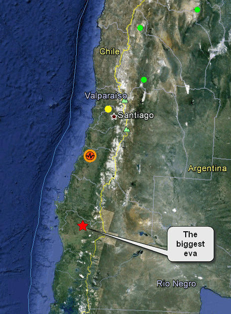
USGS page for the Valdiva Earthquake 1960
There have been a number of aftershocks but they are not large enough to figure in the USGS lists.
Chile INFORME DE ULTIMOS SISMOS CON MAGNITUD IGUAL O SUPERIOR A 3.0 (1)
There undoubtedly will be some bigger aftershocks but Chile is not nearly as profuse with large aftershocks as some areas.
Of course inevitably there are the theories that the 2010 quake did not dissipate the energy in the Northern region and that this was just the foreshock for a Mag 9.
In my opinion as a non-professional non-seismologist I am not sure that I go along with this however I am not discounting it completely. It based on the Mag 9 of 1960 I believe, but that was actually south of the current event.
USGS page for the Valdiva Earthquake 1960
reply to post by muzzy
Mm, -4 from -16 (round figures) = -12 @ ~117 = 1404. So just im pure latitude term s The Fiji quake was 1404 miles further SOUTH than the CEPR as well as being just 1/4th the distance.
Curious I am, and not convinced. May the Force be with you.
The only thing I can think of is that its too far north for SNZO.
Mm, -4 from -16 (round figures) = -12 @ ~117 = 1404. So just im pure latitude term s The Fiji quake was 1404 miles further SOUTH than the CEPR as well as being just 1/4th the distance.
Curious I am, and not convinced. May the Force be with you.
Clintonville is on the map. CNN was there for three days.
I thought Clintonville was already on the map and I thought they called it Little Rock.
www.wsaw.com...
And you know Little Rock was CIA central for the drug trade right?
Getting back to Wisconsin. I love them cheeseheads. I love how excited they are by these "earthquakes".
"I survived the 1.5!"
At first I wondered which industry was at fault. Maybe I should stop going into things with a prejudiced mind. Water extraction seemed plausable at first. But. Wisconsinites are a funny bunch. They like the land they live on and wanted to protect their watershed. Unlike Michigan. Michigan is selling their water rites to many companies.
Like Nestle. Wisconsin has stricter regulations on water rights.
For Bottled Water. Wasteful crap. Coke takes Detroit City water and cleans it first and sells it as good stuff. hmmm - i mean mmmmm....
(Did you know that the St Clair river once caught on fire?) * (I checked and it may have been the Detroit River. Although details are sketchy and everyone could be thinking about the Cuyahoga in Ohio.)
www.environmentalcouncil.org...
Anyway. Whatever was banging in basement in Clintonville was probably natural.
Actually. I don't believe that either. North America is going to split in half.
Right down the middle. From Wisconsin/Minnesota all the way to Lousiana.
The United States of America will literally rip itself in half.
edit on 26-3-2012 by ericblair4891 because: (no reason given)
edit on 26-3-2012 by ericblair4891 because: (no reason
given)
edit on 26-3-2012 by ericblair4891 because: (no reason given)
edit on 26-3-2012 by ericblair4891 because: (no
reason given)
reply to post by ericblair4891
I wonder if there is a way to check the change in water depth of the Missouri and Mississippi Rivers. Are they getting deeper or shallower? If a split is coming, the rivers will tell the tale early.
Given the massive number of caves/voids along the Mississippi here in Missouri, I try to picture a splitting river and water filling up the area.
And I may end up with waterfront property!
In an interesting related comment, our personal sinkhole is bone dry, despite all the rain. I wonder where it drains and if it can back up.
Source parameters not yet reviewed by a seismologist
source(www.emsc-csem.org...
Magnitude mb 5.8
Region SOUTHWEST INDIAN RIDGE
Date time 2012-03-26 16:58:17.0 UTC Location 30.12 S ; 60.66 E
Depth 60 km
Distances 1822 km SE Antananarivo (pop 1,391,433 ; local time 19:58:17.2 2012-03-26) 1138 km S Vascoas-phoenix (pop 106,761 ; local time 20:58:17.2 2012-03-26) 1097 km SE Saint-joseph (pop 33,694 ; local time 20:58:17.2 2012-03-26)
edit on 26-3-2012 by diamondsmith because:
add
edit on 26-3-2012 by diamondsmith because: (poorly constrained
This event has been reviewed by a seismologist.
source(earthquake.usgs.gov...
Magnitude 6.0
Date-Time Monday, March 26, 2012 at 18:12:54 UTC Monday, March 26, 2012 at 11:12:54 AM at epicenter
Location 10.198°N, 104.030°W
Depth 9.9 km (6.2 miles) Region NORTHERN EAST PACIFIC RISE
Distances 863 km (536 miles) SSW (212°) from Acapulco, Guerrero, Mexico
Location Uncertainty horizontal +/- 20.3 km (12.6 miles); depth +/- 2.7 km (1.7 miles)
Parameters NST=315, Nph=315, Dmin=>999 km, Rmss=1.45 sec, Gp= 97°, M-type=regional moment magnitude (Mw), Version=A
edit on 26-3-2012 by diamondsmith because: This
event has been reviewed by a seismologist.
source(quakes.globalincidentmap.com...
Type: Earthquake 47 minutes ago
Magnitude: 5
DateTime: Monday March 26 2012, 17:58:27 UTC
Region: northern East Pacific Rise Depth: 10.3 km
Source: USGS Feed
edit on 26-3-2012 by diamondsmith because: add
Magnitude Mw 6.0
Region NORTHERN EAST PACIFIC RISE
Date time 2012-03-26 18:12:54.0 UTC
Location 10.20 N ; 104.03 W
Depth 10 km
Distances 862 km SW Acapulco (pop 652,136 ; local time 12:12:54.4 2012-03-26)
863 km SW Tecpan (pop 14,638 ; local time 12:12:54.4 2012-03-26)
1153 km SW Mexico city (pop 8,657,050 ; local time 12:12:54.4 2012-03-26)
EMSC
Good ole jolts - appears we are bouncing back and forth
Source
Magnitude 6.0 - NORTHERN EAST PACIFIC RISE
2012 March 26 18:12:54 UTC
DetailsMapsEarthquake Details
This event has been reviewed by a seismologist.
Magnitude 6.0
Date-Time Monday, March 26, 2012 at 18:12:54 UTC
Monday, March 26, 2012 at 11:12:54 AM at epicenter
Location 10.198°N, 104.030°W
Depth 9.9 km (6.2 miles)
Region NORTHERN EAST PACIFIC RISE
Distances 863 km (536 miles) SSW (212°) from Acapulco, Guerrero, Mexico
Location Uncertainty horizontal +/- 20.3 km (12.6 miles); depth +/- 2.7 km (1.7 miles)
Parameters NST=315, Nph=315, Dmin=>999 km, Rmss=1.45 sec, Gp= 97°,
M-type=regional moment magnitude (Mw), Version=A
Source Magnitude: USGS NEIC (WDCS-D)
Location: USGS NEIC (WDCS-D)
Event ID usc0008qdx
Source
edit on 26-3-2012 by Anmarie96 because: Forgot the
dreaded source
edit on 26-3-2012 by Anmarie96 because: (no reason given)
new topics
-
Late Night with the Devil - a really good unusual modern horror film.
Movies: 47 minutes ago -
Cats Used as Live Bait to Train Ferocious Pitbulls in Illegal NYC Dogfighting
Social Issues and Civil Unrest: 2 hours ago -
The Good News According to Jesus - Episode 1
Religion, Faith, And Theology: 4 hours ago -
HORRIBLE !! Russian Soldier Drinking Own Urine To Survive In Battle
World War Three: 6 hours ago -
Bobiverse
Fantasy & Science Fiction: 8 hours ago -
Florida man's trip overseas ends in shock over $143,000 T-Mobile phone bill
Social Issues and Civil Unrest: 9 hours ago -
Former Labour minister Frank Field dies aged 81
People: 11 hours ago
top topics
-
President BIDEN Vows to Make Americans Pay More Federal Taxes in 2025 - Political Suicide.
2024 Elections: 17 hours ago, 21 flags -
Florida man's trip overseas ends in shock over $143,000 T-Mobile phone bill
Social Issues and Civil Unrest: 9 hours ago, 8 flags -
SETI chief says US has no evidence for alien technology. 'And we never have'
Aliens and UFOs: 12 hours ago, 7 flags -
Cats Used as Live Bait to Train Ferocious Pitbulls in Illegal NYC Dogfighting
Social Issues and Civil Unrest: 2 hours ago, 6 flags -
This is our Story
General Entertainment: 15 hours ago, 4 flags -
Former Labour minister Frank Field dies aged 81
People: 11 hours ago, 4 flags -
Bobiverse
Fantasy & Science Fiction: 8 hours ago, 3 flags -
HORRIBLE !! Russian Soldier Drinking Own Urine To Survive In Battle
World War Three: 6 hours ago, 2 flags -
Late Night with the Devil - a really good unusual modern horror film.
Movies: 47 minutes ago, 2 flags -
The Good News According to Jesus - Episode 1
Religion, Faith, And Theology: 4 hours ago, 0 flags
active topics
-
British TV Presenter Refuses To Use Guest's Preferred Pronouns
Education and Media • 138 • : Consvoli -
Florida man's trip overseas ends in shock over $143,000 T-Mobile phone bill
Social Issues and Civil Unrest • 15 • : mysterioustranger -
SETI chief says US has no evidence for alien technology. 'And we never have'
Aliens and UFOs • 35 • : Consvoli -
Late Night with the Devil - a really good unusual modern horror film.
Movies • 1 • : DAVID64 -
Cats Used as Live Bait to Train Ferocious Pitbulls in Illegal NYC Dogfighting
Social Issues and Civil Unrest • 6 • : ColeYounger2 -
Ditching physical money
History • 18 • : annonentity -
Lawsuit Seeks to ‘Ban the Jab’ in Florida
Diseases and Pandemics • 32 • : SchrodingersRat -
President BIDEN Vows to Make Americans Pay More Federal Taxes in 2025 - Political Suicide.
2024 Elections • 91 • : rickymouse -
HORRIBLE !! Russian Soldier Drinking Own Urine To Survive In Battle
World War Three • 21 • : Justoneman -
"We're All Hamas" Heard at Columbia University Protests
Social Issues and Civil Unrest • 279 • : KrustyKrab