It looks like you're using an Ad Blocker.
Please white-list or disable AboveTopSecret.com in your ad-blocking tool.
Thank you.
Some features of ATS will be disabled while you continue to use an ad-blocker.

Quake Watch 2012
page: 84share:
Another addition to the collection of Mag 6.0 quakes. Changed scales from mb to Mw after the
7th day (?) although it does not actually state a scale anywhere - even on the phase data.
Note EMSC and JMO already had this at 6.0 Mw/6.1 ML
This shows as Mw only in the qed.txt file
Date/Time UTC,Latitude,Longitude,Magnitude,Depth(Km),Location
2012-03-14 12:05:00, 35.800, 141.100, 6.1, 10.0, Chiba-Ken Toho-Oki
2012-03-14 12:05:04, 35.710, 140.747, 6.0, 10.0, Nr. E. Coast Of Honshu Japan
2012-03-14 12:05:05, 35.709, 140.737, 5.7, 16.9, Nr. E. Coast Of Honshu. Japan
Note EMSC and JMO already had this at 6.0 Mw/6.1 ML
This shows as Mw only in the qed.txt file
120504.5 35.691N 140.686E 10G 5.7 5.6 A 0.8 24 425 NEAR THE EAST COAST OF HONSHU, JAPAN. MW 6.0
reply to post by PuterMan
I thought I placed a reading for the Pacific- Arctic Ridge also sorry
it was starting to look like circle or ring pattern to me, all around the Pacific.
I thought I placed a reading for the Pacific- Arctic Ridge also sorry
it was starting to look like circle or ring pattern to me, all around the Pacific.
Type: Earthquake
3 hours ago
Magnitude: 5.1
DateTime: Sunday March 25 2012, 10:26:55 UTC
Region: South Sandwich Islands Region
Depth: 60 km
Source: CSEM-EMSC Feed
3 hours ago
Magnitude: 5.1
DateTime: Sunday March 25 2012, 10:26:55 UTC
Region: South Sandwich Islands Region
Depth: 60 km
Source: CSEM-EMSC Feed
Source parameters not yet reviewed by a seismologist
source(www.emsc-csem.org...
Magnitude mb 5.3
Region FIJI REGION
Date time 2012-03-25 13:59:20.5 UTC
Location 18.76 S ; 178.78 W
Depth 462 km
Distances 3033 km E Brisbane (pop 1,843,392 ; local time 23:59:20.5 2012-03-25) 303 km E Suva (pop 199,455 ; local time 01:59:20.5 2012-03-26) 296 km E Nausori (pop 32,786 ; local time 01:59:20.5 2012-03-26) 59 km S Tubou (pop 578 ; local time 01:59:20.5 2012-03-26)
Very deep,
and concerning
edit on 25-3-2012 by diamondsmith because: concerning
Because is building up,
source(quakes.globalincidentmap.com...
Type: Earthquake 33 minutes ago
Magnitude: 4.9
DateTime: Sunday March 25 2012, 14:18:46 UTC
Region: Fiji Region Depth: 548 km Source: CSEM-EMSC Feed
reply to post by PuterMan
Yeah the settings of LISS seem to be for long distance quakes, if that 4.8 had been in Cook Strait for example it would have been barely a wiggle. On that CEPR one the arrival time of the LR waves is spot on 04:37:00. If you look to the left along that line on my marked SNZO you can see the disturbance of the P wave starting at 04:11:22, then after the 2nd "heave" it flattens out and thats the arrival of the S wave at 04:21:30.
All that calculated using the Earthquakes Travel Times Computer
I wouldn't be surprised if USGS use this computer to calculate the travel times for the phase data, although its obviously automated, as the P wave times always match up when you do a manual calculation. I set the phases option to "all branches" to get the S and LR wave arrival times.
My understanding is that because the CEPR quake trace is quite small, its because of the extra distance when compared to the Pac-Ant Ridge. And I think you could probably add at least 0.3 or 0.4 to both USGS's magnitudes (based on previous traces on SNZO).
Indeed Geofon had an extra 0.6 on the Pac-Ant one
geofon.gfz-potsdam.de...
I called it 5.6 last night (posted on 25-3-2012 @ 10:56 PM NZST) when Geofon was off line, good guess
for that unidentified one
the SNZO graph shows
P=22:25:00 + 6 minutes
S=22:31:00 +4 minutes
LR=22:35:00
compare with the Pac Ant one
P=01:12:45 + 5.53 minutes
S=01:18:17 + 4 minutes
LR= 01:22:17
and then the CEPR
P=04:11:22 +10.13 minutes
S=04:21:30 + 15.50 minutes
LR= 04:37:00
so I'd say again same spot as the Pac-Ant 5.7, but less magnitude, or deeper, possibly 5.2.
We'll have to wait the 7 days I guess
Yeah the settings of LISS seem to be for long distance quakes, if that 4.8 had been in Cook Strait for example it would have been barely a wiggle. On that CEPR one the arrival time of the LR waves is spot on 04:37:00. If you look to the left along that line on my marked SNZO you can see the disturbance of the P wave starting at 04:11:22, then after the 2nd "heave" it flattens out and thats the arrival of the S wave at 04:21:30.
All that calculated using the Earthquakes Travel Times Computer
I wouldn't be surprised if USGS use this computer to calculate the travel times for the phase data, although its obviously automated, as the P wave times always match up when you do a manual calculation. I set the phases option to "all branches" to get the S and LR wave arrival times.
My understanding is that because the CEPR quake trace is quite small, its because of the extra distance when compared to the Pac-Ant Ridge. And I think you could probably add at least 0.3 or 0.4 to both USGS's magnitudes (based on previous traces on SNZO).
Indeed Geofon had an extra 0.6 on the Pac-Ant one
2012-03-25 01:05:34, 5.7 , 54.35°S, 135.80°W, 10 , M , MT, Pacific Antarctic Ridge
geofon.gfz-potsdam.de...
I called it 5.6 last night (posted on 25-3-2012 @ 10:56 PM NZST) when Geofon was off line, good guess
for that unidentified one
the SNZO graph shows
P=22:25:00 + 6 minutes
S=22:31:00 +4 minutes
LR=22:35:00
compare with the Pac Ant one
P=01:12:45 + 5.53 minutes
S=01:18:17 + 4 minutes
LR= 01:22:17
and then the CEPR
P=04:11:22 +10.13 minutes
S=04:21:30 + 15.50 minutes
LR= 04:37:00
so I'd say again same spot as the Pac-Ant 5.7, but less magnitude, or deeper, possibly 5.2.
We'll have to wait the 7 days I guess
edit on 25-3-2012 by muzzy because: (no reason given)
reply to post by PuterMan
That qedevents.txt is quite handy, it shows Me, which you don't see much these days, was popular in the 1980's. Always handy to have all the data you can get your hands on
eg
PAPUA, INDONESIA. MW 6.1 (WCMT), 6.2 (GS). ME 6.0 (GS)
OAXACA, MEXICO. MW 7.4 (WCMT), 7.4 (UCMT), 7.3 (GS). ME 7.7 (GS)
NEW GUINEA, PAPUA NEW GUINEA. MW 6.6 (WCMT), 6.6 (UCMT), 6.6 (GS). ME 6.0 (GS). WP 6.7 (PMR)
and this one
18/03/2012 19:50:24 SOUTHERN EAST PACIFIC RISE. MW 5.8 (WCMT), 5.7 (GS)
for some unknown reason I didn't down load SNZO that day or the day after, it would likely have been a decent trace, and useful for what we discussed over yesterdays 2 quakes out there in that area.
So how do you get to that page? is it just weekly? do you need a programme to download it? (I notice the address starts with ftp:// )
edit on
25-3-2012 by muzzy because: (no reason given)
reply to post by muzzy
I just have the full address as a bookmark. Once in your browser simply save it. It is updated regularly, at least once a day.
On forgot to add, I download it every day at midday and I have a file for each day since 11th December 2011 so if you want the file for a day just let me know.
The 11 Dec file goes back to Oct 29th so I am covered from then.
So how do you get to that page? is it just weekly? do you need a programme to download it? (I notice the address starts with ftp:// )
I just have the full address as a bookmark. Once in your browser simply save it. It is updated regularly, at least once a day.
On forgot to add, I download it every day at midday and I have a file for each day since 11th December 2011 so if you want the file for a day just let me know.
The 11 Dec file goes back to Oct 29th so I am covered from then.
edit on 25/3/2012 by PuterMan because: (no reason given)
reply to post by muzzy
I would love to agree with you Muzzy but I still have a problem with that being CEPR
earthquake.usgs.gov...
One pip under but way closer. About 2780 km against 8960 km
So according to your hypothesis there should be a fat wiggle at 11:36
There should at least be something but that trace would be successful in an audition for "Flatliners"
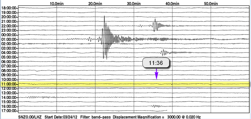
From the calculator for the CEPR
Compare to above
In english
0.4330
2.4100
So the amplitude of the Fiji wave is calculated to be 2.41 against 0.433 - over 5.5 times as great yet it does not show?
Any thoughts on why that might be? Or have I made an error in logic?
I would love to agree with you Muzzy but I still have a problem with that being CEPR
earthquake.usgs.gov...
Magnitude 4.7 - FIJI
2012 March 25 11:27:15 UTC
One pip under but way closer. About 2780 km against 8960 km
Travel Times to YOUR Seismic Station
Based on the information that you submitted:
Station Coordinates : -41.3009987 174.695999
Earthquake Latitude and Longitude: -16.4060001 177.804993
Earthquake Depth (km): 24.2999992
Earthquake Time: 11 27 15
Earthquake Magnitude: 4.69999981
Compute travel times for all branches
Expected 20s period surface wave amplitude [ 2.41E+00 µm] [ 7.57E-01 µm/s]
Expected 1s period body wave amplitude [ 2.00E-02 µm] [ 1.26E-01 µm/s]
Delta Azimuth (degrees clockwise from north)
(deg) eq-to-station station-to-eq
24.95 185.6 7.1
travel arrival time
# code time(s) dy hr mn sec
1 P 321.40 0 11 32 36
2 P 323.28 0 11 32 38
3 pP 328.59 0 11 32 43
4 pP 330.15 0 11 32 45
5 sP 331.81 0 11 32 46
6 sP 333.44 0 11 32 48
7 PnPn 354.75 0 11 33 9
8 PcP 536.00 0 11 36 10
9 S 584.52 0 11 36 59
10 S 591.00 0 11 37 6
11 SPg 591.60 0 11 37 6
12 pS 592.85 0 11 37 7
13 sS 596.89 0 11 37 11
14 sS 602.63 0 11 37 17
15 SnSn 634.93 0 11 37 49
16 ScP 753.29 0 11 39 48
17 PcS 756.30 0 11 39 51
18 ScS 981.66 0 11 43 36
19 PKiKP 997.41 0 11 43 52
20 pPKiKP 1005.62 0 11 44 0
21 sPKiKP 1008.61 0 11 44 3
22 SKiKP 1206.94 0 11 47 21
23 PKKPdf 1906.28 0 11 59 1
24 SKKPdf 2115.82 0 12 2 30
25 PKKSdf 2118.81 0 12 2 33
26 SKKSdf 2328.31 0 12 6 3
27 P'P'df 2415.25 0 12 7 30
28 P'P'ab 2542.65 0 12 9 37
29 S'S'df 3263.00 0 12 21 38
30 LQ 633.31 0 11 37 48
31 LR 702.88 0 11 38 57
So according to your hypothesis there should be a fat wiggle at 11:36
There should at least be something but that trace would be successful in an audition for "Flatliners"
From the calculator for the CEPR
Expected 20s period surface wave amplitude [ 4.33E-01 µm] [ 1.36E-01 µm/s]
Expected 1s period body wave amplitude [ 1.05E-02 µm] [ 6.62E-02 µm/s]
Compare to above
Expected 20s period surface wave amplitude [ 2.41E+00 µm] [ 7.57E-01 µm/s]
Expected 1s period body wave amplitude [ 2.00E-02 µm] [ 1.26E-01 µm/s]
In english
0.4330
2.4100
So the amplitude of the Fiji wave is calculated to be 2.41 against 0.433 - over 5.5 times as great yet it does not show?
Any thoughts on why that might be? Or have I made an error in logic?
edit on 25/3/2012 by PuterMan because: (no reason given)
Magnitude 7.2 offshore Maule. Chile
Location in Google Maps
- Date-Time: Sunday, March 25, 2012 at 22:37:04 UTC
Sunday, March 25, 2012 at 06:37:04 PM at epicenter
- Location: 35.116°S, 72.658°W
- Depth: 10 km (6.2 miles) set by location program
- Region: OFFSHORE MAULE, CHILE
- Distances:
98 km [61 miles] WNW [293°] from Talca, Chile
194 km [121 miles] N [11°] from Concepcion, Chile
244 km [152 miles] SSW [202°] from Valparaiso, Chile
256 km [159 miles] SW [225°] from SANTIAGO, Chile
- Location Uncertainty: Error estimate not available
- Parameters: NST= 9, Nph=0, Dmin=0 km, Rmss=0 sec, Gp=187°,M-type="moment" magnitude from initial P wave (tsuboi method) (Mi/Mwp),
Version=B
- Source: NOAA Pacific Tsunami Warning Center
- Event ID: pt12085000
Derived from Data Source: USGS
Powered by QVSData
NOAA has screwed up the tsunami data. Showing the location but no data.
EMSC
Magnitude mb 6.2
Region MAULE, CHILE
Date time 2012-03-25 22:37:04.5 UTC
Location 35.15 S ; 71.81 W
Depth 5 km
Distances 216 km SW Santiago (pop 4,837,295 ; local time 18:37:04.5 2012-03-25)
33 km NW Talca (pop 197,479 ; local time 18:37:04.5 2012-03-25)
48 km W Molina (pop 28,775 ; local time 18:37:04.5 2012-03-25)
Global view
Source parameters not yet reviewed by a seismologist
USGS has been reviewed
000
WEHW42 PHEB 252245
TIBHWX
HIZ001>003-005>009-012>014-016>021-023>026-260045-
TSUNAMI INFORMATION STATEMENT NUMBER 1
NWS PACIFIC TSUNAMI WARNING CENTER EWA BEACH HI
1245 PM HST SUN MAR 25 2012
TO - CIVIL DEFENSE IN THE STATE OF HAWAII
SUBJECT - TSUNAMI INFORMATION STATEMENT
THIS STATEMENT IS FOR INFORMATION ONLY. NO ACTION REQUIRED.
AN EARTHQUAKE HAS OCCURRED WITH THESE PRELIMINARY PARAMETERS
ORIGIN TIME - 1237 PM HST 25 MAR 2012
COORDINATES - 35.1 SOUTH 72.7 WEST
LOCATION - NEAR COAST OF CENTRAL CHILE
MAGNITUDE - 7.2 MOMENT
EVALUATION
BASED ON ALL AVAILABLE DATA A DESTRUCTIVE PACIFIC-WIDE TSUNAMI IS
NOT EXPECTED AND THERE IS NO TSUNAMI THREAT TO HAWAII. REPEAT. A
DESTRUCTIVE PACIFIC-WIDE TSUNAMI IS NOT EXPECTED AND THERE IS NO
TSUNAMI THREAT TO HAWAII.
THIS WILL BE THE ONLY STATEMENT ISSUED FOR THIS EVENT UNLESS
ADDITIONAL DATA ARE RECEIVED.
$$
Tsunami info
New USGS ID
Waiting for the tensor solutions and phase data. Not in yet.
EMSC now coming back at 7.0 mb
Magnitude mb 7.0
Region MAULE, CHILE
Date time 2012-03-25 22:37:08.0 UTC
Location 35.22 S ; 71.92 W
Depth 47 km
Distances 228 km SW Santiago (pop 4,837,295 ; local time 18:37:08.0 2012-03-25)
32 km NW Talca (pop 197,479 ; local time 18:37:08.0 2012-03-25)
44 km NW San javier (pop 22,427 ; local time 18:37:08.0 2012-03-25)
www.emsc-csem.org...
Chile Ultimos Sismos Sensibles
Informe 2012/03/25 19:37:06 -35.186 -72.235 41.3 6.4 Ml GUC Si Si 24 km al NE de Constitución
Yes that is 6.4 ML
GeoAzur in with a moment tensor @ 7.1 Mw
To: [email protected]
From: [email protected]
Subject: [SCARDEC] Recent Mw=7.1 earthquake, located in MAULE, CHILE
Message-Id:
Date: Mon, 26 Mar 2012 01:20:11 +0200 (CEST)
2012 03 25 22 37 06.0 -35.198 -71.783 39.0 7.1 5 19 99 175 71 87
INDICATIF_SEISME 20120325_223706_MAULE__CHILE
EMSC Full tensor solutions
Alert information for this event is currently under review and will be available soon. Thank you for your patience.
earthquake.usgs.gov...
Several MILLION people in the area exposed.
edit on 25/3/2012 by PuterMan because: (no reason given)
Type: Earthquake
24 minutes ago
Magnitude: 3
DateTime: Sunday March 25 2012, 23:07:50 UTC
Region: Utah
Depth: 0.3 km
Source: USGS Feed
quakes.globalincidentmap.com...
24 minutes ago
Magnitude: 3
DateTime: Sunday March 25 2012, 23:07:50 UTC
Region: Utah
Depth: 0.3 km
Source: USGS Feed
quakes.globalincidentmap.com...
The Pager information found here is still pending, but
there are a lot of people in the area near the epicenter: 197,000 in Talca alone.
I am hoping for the best for the people of Chile.
ETA: Oops, didn't see PM's thread on the above quake. But yes, big population subjected to shaking, and nightfall is quickly approaching.
I am hoping for the best for the people of Chile.
ETA: Oops, didn't see PM's thread on the above quake. But yes, big population subjected to shaking, and nightfall is quickly approaching.
edit on 3/25/2012 by Olivine because: postscript

How quickly I am reminded of the mining accident in Chile last year. I remember watching them rescue the last few while chanting "Chi, Chi, Chi, Le,
Le, Le,". I hope for the best in Chile. I can only imagine what that felt like below ground in the mines of Chile.
Update 01:17 UTC : Maule regional office decided to evacuate the region for PREVENTIVE purpose. People are saying that the ocean has retreated up to
40 meters.
earthquake-report.com...
I thought they said NO tsunami
earthquake-report.com...
I thought they said NO tsunami
reply to post by TryToGetTheTruth
The quake hit three hours ago. Is this a typical time frame for a tidal wave? I thought it would come in sooner than that?
The quake hit three hours ago. Is this a typical time frame for a tidal wave? I thought it would come in sooner than that?
Originally posted by Doodle19815
reply to post by TryToGetTheTruth
The quake hit three hours ago. Is this a typical time frame for a tidal wave? I thought it would come in sooner than that?
I am just following Twitter, and I have no idea what is going on..I thought a wave would have been there by now too, but the sea has gone out. The best I get is here earthquake-report.com...
Interesting diagonal;
CHILE 4 hours ago
JAPAN 32 minutes ago
RUSSIA 29 minutes ago
quakes.globalincidentmap.com...
CHILE 4 hours ago
JAPAN 32 minutes ago
RUSSIA 29 minutes ago
quakes.globalincidentmap.com...
new topics
-
Any one suspicious of fever promotions events, major investor Goldman Sachs card only.
The Gray Area: 1 hours ago -
God's Righteousness is Greater than Our Wrath
Religion, Faith, And Theology: 5 hours ago -
Electrical tricks for saving money
Education and Media: 8 hours ago -
VP's Secret Service agent brawls with other agents at Andrews
Mainstream News: 10 hours ago -
Sunak spinning the sickness figures
Other Current Events: 10 hours ago -
Nearly 70% Of Americans Want Talks To End War In Ukraine
Political Issues: 11 hours ago
top topics
-
VP's Secret Service agent brawls with other agents at Andrews
Mainstream News: 10 hours ago, 9 flags -
Cats Used as Live Bait to Train Ferocious Pitbulls in Illegal NYC Dogfighting
Social Issues and Civil Unrest: 14 hours ago, 8 flags -
Electrical tricks for saving money
Education and Media: 8 hours ago, 4 flags -
Nearly 70% Of Americans Want Talks To End War In Ukraine
Political Issues: 11 hours ago, 3 flags -
Sunak spinning the sickness figures
Other Current Events: 10 hours ago, 3 flags -
Late Night with the Devil - a really good unusual modern horror film.
Movies: 12 hours ago, 2 flags -
The Good News According to Jesus - Episode 1
Religion, Faith, And Theology: 16 hours ago, 1 flags -
Any one suspicious of fever promotions events, major investor Goldman Sachs card only.
The Gray Area: 1 hours ago, 1 flags -
God's Righteousness is Greater than Our Wrath
Religion, Faith, And Theology: 5 hours ago, 0 flags
active topics
-
God's Righteousness is Greater than Our Wrath
Religion, Faith, And Theology • 9 • : andy06shake -
-@TH3WH17ERABB17- -Q- ---TIME TO SHOW THE WORLD--- -Part- --44--
Dissecting Disinformation • 661 • : Justoneman -
SETI chief says US has no evidence for alien technology. 'And we never have'
Aliens and UFOs • 59 • : andy06shake -
HORRIBLE !! Russian Soldier Drinking Own Urine To Survive In Battle
World War Three • 36 • : TheMisguidedAngel -
British TV Presenter Refuses To Use Guest's Preferred Pronouns
Education and Media • 146 • : Consvoli -
Nearly 70% Of Americans Want Talks To End War In Ukraine
Political Issues • 19 • : Consvoli -
Terrifying Encounters With The Black Eyed Kids
Paranormal Studies • 76 • : Consvoli -
Samuel Aun Woer
Religion, Faith, And Theology • 27 • : helebi20 -
Any one suspicious of fever promotions events, major investor Goldman Sachs card only.
The Gray Area • 2 • : Cavemannick -
VP's Secret Service agent brawls with other agents at Andrews
Mainstream News • 42 • : 38181