It looks like you're using an Ad Blocker.
Please white-list or disable AboveTopSecret.com in your ad-blocking tool.
Thank you.
Some features of ATS will be disabled while you continue to use an ad-blocker.

Quake Watch 2012
page: 43share:
reply to post by zworld
Hi zworld. Those top 2 quakes you posted are from The Geysers area. It's the largest geothermal facility in the world. That's why it has so many quakes daily. It is also above the hypothosized slabless window. So the heat is close to the surface. I believe the 4.3 you listed is on the high side magnitude-wise, for the area.
How you doing after the big shake? The background "noise" on the spectrograms and seismos I've been following in your area haven't quieted down yet--keep safe.
ETA: Sorry 'bout that, Puterman. Didn't see you already had mentioned the Geysers.
Hi zworld. Those top 2 quakes you posted are from The Geysers area. It's the largest geothermal facility in the world. That's why it has so many quakes daily. It is also above the hypothosized slabless window. So the heat is close to the surface. I believe the 4.3 you listed is on the high side magnitude-wise, for the area.
How you doing after the big shake? The background "noise" on the spectrograms and seismos I've been following in your area haven't quieted down yet--keep safe.
edit on 2/13/2012 by Olivine because: spelling
ETA: Sorry 'bout that, Puterman. Didn't see you already had mentioned the Geysers.
edit on 2/13/2012 by Olivine because: (no reason
given)
reply to post by PuterMan
Heeelllo Puterman
I was looking at the spikey ones @ 19:07 and 19:08 UTC. The one at 17:44:20 looks earthquakish too, but I was wandering around then--didn't feel anything.
So the ones that look like trains; any chance those could be small shakes from way out to sea? Like maybe Mag 3"s from the Mid-Atlantic Ridge? I've been searching for seismos in near real-time near the ridge with no luck. You have any favorites in that humongous area?
edit on 2/13/2012 by
Olivine because: more spelling issues
reply to post by Olivine
Sorry, just added to my other post - trains. See the bottom of the previous page. Track is 3.36 miles and curves round past the station.
Closest to the MAR are PM.ROSA and II.CMLA (The are almost on it)
IU.BBSR is about half way there
If I was the PNSN I would say those were military jets breaking the sound barrier, and if I was the PNSN I might be right because the sure don't sound like earthquakes.
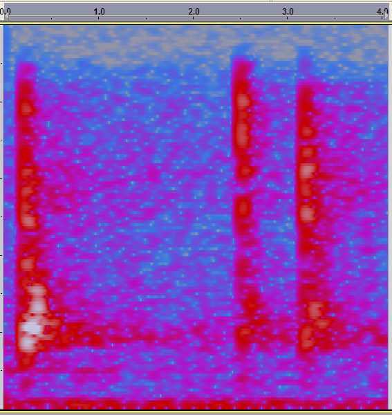
Sound in a few minutes - look back in this post.
dl.dropbox.com...
Sorry has to be a zip because of ATS T & C.
Sorry, just added to my other post - trains. See the bottom of the previous page. Track is 3.36 miles and curves round past the station.
Closest to the MAR are PM.ROSA and II.CMLA (The are almost on it)
IU.BBSR is about half way there
edit on 13/2/2012 by PuterMan because: (no reason given)
If I was the PNSN I would say those were military jets breaking the sound barrier, and if I was the PNSN I might be right because the sure don't sound like earthquakes.
Sound in a few minutes - look back in this post.
edit on 13/2/2012 by PuterMan because: (no reason given)
dl.dropbox.com...
Sorry has to be a zip because of ATS T & C.
edit on 13/2/2012 by PuterMan because: (no reason given)
reply to post by Olivine
Larger but certainly not unknown
There is a list of counts quakes to 2010 on the second page.
www.scribd.com...
I believe the 4.3 you listed is on the high side magnitude-wise, for the area.
Larger but certainly not unknown
There is a list of counts quakes to 2010 on the second page.
www.scribd.com...
With the little bit of action the PNW is getting , is anyone else a tad nervous about the Cascadia Subduction Zone?
I guess it just makes me extra-aware that things are making a little more noise up there "than usual".
Just want some thoughts I am fully aware the Earth has to stretch and move from time to time.
I guess it just makes me extra-aware that things are making a little more noise up there "than usual".
Just want some thoughts I am fully aware the Earth has to stretch and move from time to time.
Puterman, your right, those are strange sounding earthquakes.
Nice find on the link about The Geysers' earthquakes. I couldn't remember ever seeing a Mag 5 or larger in that immediate area, and skimming your link, they don't seem to happen (well not in recent times)
Looking at the focal mechanism given for todays Mag 5.6 near Weitchpec, it looks to be a normal-type fault (extensional). I compared the location with some of my geological maps of the area, and the epicenter given is nearly on top of a long, very old fault (the South Fork fault) from the Jurassic (the exact age is still being debated but safely put at 120-140 Mya (Mya = millions of years ago--when exotic terranes were still attaching to the west coast).
Here is a link to the USGS -- styles of faults page. It has pics of the different types of faults.
Todays quake is most probably related to the subduction zone and all of its accumulated stress, but the normal style of faulting doesn't make me think this was a plate interface quake. Also factoring in the depth of almost 33km, when the estimated plate interface depth at that location is very close to 20km, leads me to think todays quake originated in or possibly below the subducting slab.
edit on 2/13/2012 by Olivine because: (no reason
given)
edit on 2/13/2012 by Olivine because: add a link
edit on 2/13/2012 by Olivine because: spelling
This event has been reviewed by a seismologist.
Magnitude 5.3
Date-Time:
Tuesday, February 14, 2012 at 01:34:41 UTC
Tuesday, February 14, 2012 at 03:34:41 AM at epicenter
Location:
40.160°N, 23.999°E Depth 16.7 km (10.4 miles)
Region:
GREECE
Distances:
93 km (57 miles) SSW of Kavalla,
Greece 104 km (64 miles) ESE of Thessaloniki,
Greece 147 km (91 miles) ENE of Larisa,
Greece 242 km (150 miles) N of ATHENS, Greece
Location Uncertainty: horizontal +/- 12.9 km (8.0 miles); depth +/- 9 km (5.6 miles)
Parameters:
NST= 75, Nph= 79, Dmin=191.5 km, Rmss=1.14 sec, Gp= 54°,
M-type=body wave magnitude (Mb), Version=4
Source
Magnitude: USGS NEIC (WDCS-D)
Location: USGS NEIC (WDCS-D)
Event ID usb0008011
USGS
edit on 13-2-2012 by skitzspiricy because: (no reason
given)
Originally posted by Olivine
How you doing after the big shake?
A couple of small movements, nothing really. But even the 5.6 wasn't much of a shake here in Eureka. Depth and distance. Not even much out on the rez close to where it hit. From a local paper.
Juice, bottles of pasta sauce and other items topple off shelves at Ray's Food Place in Hoopa, but the quake didn't do major damage, said store Manager David Gillan. There were about 10 to 15 customers shopping at the time.
The earthquake occurred about 20 miles beneath the earth's surface, which is typical for Humboldt County's inland earthquakes, said HSU geology professor Lori Dengler. The quake occurred on a fault that is unnamed because it doesn't reach the surface. Humboldt County is full of unnamed faults that either haven't been studied or can't be seen, she said.
Full of unnamed faults. That's reassuring. So is the fact that M. Night Shyamalan is going to film his new science fiction thriller, “After Earth,” here starting soon. He better hurry up or it may be too late and 'after humans'.
ON EDIT. Oooh. That was a rather large aftershock I just felt. Checking it out.
edit on 13-2-2012 by zworld because: (no reason given)
Final upgrade on the Cali quake
earthquake.usgs.gov...
aftershock
earthquake.usgs.gov...
And this is no where near the Geysers!
Magnitude
5.6
Date-Time
Monday, February 13, 2012 at 21:07:02 UTC
Monday, February 13, 2012 at 01:07:02 PM at epicenter
Time of Earthquake in other Time Zones
Location
41.143°N, 123.790°W
Depth
28.2 km (17.5 miles)
Region
NORTHERN CALIFORNIA
Distances
9 km (5 miles) SW (234°) from Weitchpec, CA
28 km (17 miles) NNW (343°) from Willow Creek, CA
29 km (18 miles) ENE (67°) from Westhaven-Moonstone, CA
50 km (31 miles) NE (38°) from Eureka, CA
349 km (217 miles) NW (326°) from Sacramento, CA
Location Uncertainty
horizontal +/- 0.4 km (0.2 miles); depth +/- 1.2 km (0.7 miles)
Parameters
Nph= 47, Dmin=20 km, Rmss=0.27 sec, Gp= 72°,
M-type=regional moment magnitude (Mw), Version=8
Source
California Integrated Seismic Net:
USGS Caltech CGS UCB UCSD UNR
Event ID
nc71734741
earthquake.usgs.gov...
aftershock
Magnitude
2.8
Date-Time
Tuesday, February 14, 2012 at 00:19:07 UTC
Monday, February 13, 2012 at 04:19:07 PM at epicenter
Time of Earthquake in other Time Zones
Location
41.152°N, 123.785°W
Depth
32.7 km (20.3 miles)
Region
NORTHERN CALIFORNIA
Distances
8 km (5 miles) WSW (238°) from Weitchpec, CA
29 km (18 miles) NNW (344°) from Willow Creek, CA
30 km (19 miles) ENE (65°) from Westhaven-Moonstone, CA
51 km (32 miles) NE (38°) from Eureka, CA
350 km (217 miles) NW (326°) from Sacramento, CA
Location Uncertainty
horizontal +/- 0.2 km (0.1 miles); depth +/- 0.6 km (0.4 miles)
Parameters
Nph= 22, Dmin=20 km, Rmss=0.05 sec, Gp= 76°,
M-type=duration magnitude (Md), Version=3
Source
California Integrated Seismic Net:
USGS Caltech CGS UCB UCSD UNR
Event ID
nc71734806
earthquake.usgs.gov...
And this is no where near the Geysers!
OK. Guys,
I respect all of you guys. T.A. has got my feathers in a ruffle. Could someone else chime in here and lend me a hand. Is this really something we need to be concerned about? And if so, could you please let us (the ones who arn't that good at reading the instruments) know what to be looking for.
I respect all of you guys. T.A. has got my feathers in a ruffle. Could someone else chime in here and lend me a hand. Is this really something we need to be concerned about? And if so, could you please let us (the ones who arn't that good at reading the instruments) know what to be looking for.
edit on 14-2-2012 by crappiekat because: sp
Originally posted by muzzy
We just had a 3'ish shake here too at Raumati Beach, 30 seconds ago
whats the time shown on this ATS rig?
says posted on 14-2-2012 @ 10:24 AM, I'm sure it wasn't that late, but I forget now, if it was NZDT then that would have been13-2-2012 21:24 UTC.
can't find anything nearby at that time on Geonet, nearest was
3.99, -36.11597, 177.79086, 2012/2/13 21:25:24, 194 way the heck out by Rumble 4 seamount, so couldn't be that
must have just been a freak gust of wind shook the house to the foundations !
nearestquake to me location wise was
2.445, -41.01844, 175.12315, 2012/2/13 6:43:8, 27km deep,in the Tararua Mts behind us to the east, time doesn't match though
busy 24hrs for NZ though 46 quakes for the 13th UTC, and seven this afternoon, biggest a 4.884 offshore at Tauranga Trough.
bit of activity at both ends of the Volcanic Plateau, 6 to the west of Turangi and 4 at Lake Moawhango NE of Waiouru
I'll look into it again tommorrow, just checked and that time on the post is NZDT, which I set in my settings.
I thought it was earlier.
edit on 14-2-2012 by muzzy because: (no reason given)
This event has been reviewed by a seismologist.
Magnitude 6.0 Date-Time Tuesday, February 14, 2012 at 06:21:58 UTC
Tuesday, February 14, 2012 at 03:21:58 PM at epicenter Time of Earthquake in other Time Zones
Location 36.154°N, 141.494°E Depth 10 km (6.2 miles)
Region NEAR THE EAST COAST OF HONSHU, JAPAN Distances 93 km (57 miles) ESE of Mito, Honshu, Japan 113 km (70 miles) SSE of Iwaki, Honshu, Japan 151 km (93 miles) ESE of Utsunomiya, Honshu, Japan 165 km (102 miles) ENE of TOKYO, Japan
Location Uncertainty horizontal +/- 14.1 km (8.8 miles); depth +/- 2.8 km (1.7 miles) Parameters NST=298, Nph=300, Dmin=298.3 km, Rmss=0.97 sec, Gp=101°, M-type=regional moment magnitude (Mw), Version=8 Source Magnitude: USGS NEIC (WDCS-D) Location: USGS NEIC (WDCS-D) Event ID usb000802f
Source
More on the lighter side of this particular thread . . . but my sister, who is nobody in the seismological world (a nurse for an optometrist) had her
first crazy, destructive, chaotic (apocalyptic some would say ...) dream about life here in the Pacific Northwest. She came over and explained her
dream to me . . .
She said that she was in a car with her daughter, my niece, and that they were trying to get to our parents. She said that the whole road was moving so much that it threw the Jeep around to the point that they could barely stay on the road; but what really spooked her was watching the power poles . . . she said that they, and specifically the lines(the lines and poles really scared her . . . she said they were swaying everywhere), were swaying all over the place, so much so that she was afraid that they would hit them while traveling the road.
What's funny about this is that my sister NEVER has dreams or stories about this kind of thing, although, I realize that means nothing. I just thought I would share her dream with you all . . . just in case it mattered later.
edit on 14-2-2012 by nonnez because: gr
edit on
14-2-2012 by nonnez because: (no reason given)
source(earthquake.usgs.gov...
TextMagnitude 6.5 Date-Time Tuesday, February 14, 2012 at 08:19:58 UTC Tuesday, February 14, 2012 at 07:19:58 PM at epicenter Location 10.387°S, 161.262°E Depth 54.7 km (34.0 miles) Region SOLOMON ISLANDS Distances 74 km (46 miles) W (275°) from Kira Kira, Solomon Islands 176 km (110 miles) SE (126°) from HONIARA, Solomon Islands 192 km (119 miles) SSE (161°) from Auki, Solomon Islands 1543 km (959 miles) E (95°) from PORT MORESBY, Papua New Guinea Location Uncertainty horizontal +/- 14.4 km (8.9 miles); depth +/- 8.7 km (5.4 miles) Parameters Nph= 0, Dmin=0 km, Rmss=1.41 sec, Gp= 61°, M-type=regional moment magnitude (Mw), Version=7 Source Magnitude: USGS NEIC (WDCS-D) Location: NOAA, Pacific Tsunami Warning Center, Honolulu, Hawaii Event ID usb000803b
reply to post by diamondsmith
That will be going up I think. I am guessing 6.7
Are you posting direct from the USGS page. Just wondering why your text as always so difficult to read and always starts with the word text.
That will be going up I think. I am guessing 6.7
Are you posting direct from the USGS page. Just wondering why your text as always so difficult to read and always starts with the word text.
reply to post by PuterMan
Sorry P Man I try to be fast,but I promise I will improve and I will align it as it should be.

This event has been reviewed by a seismologist.
Magnitude
5.1
Date-Time
Tuesday, February 14, 2012 at 10:09:28 UTC
Tuesday, February 14, 2012 at 02:09:28 AM at epicenter
Location
32.141°N, 115.159°W
Depth
31.1 km (19.3 miles)
Region
BAJA CALIFORNIA, MEXICO
Distances
17 km (11 miles) SSW (196°) from Guadalupe Victoria, Baja California, Mexico
51 km (32 miles) SW (225°) from San Luis Río Colorado, Sonora, Mexico
54 km (34 miles) SW (223°) from San Luis, AZ
180 km (112 miles) ESE (103°) from Tijuana, Baja California, Mexico
USGS
source(earthquake.usgs.gov...
Magnitude 5.1
Date-Time Tuesday, February 14, 2012 at 10:09:28 UTC
Tuesday, February 14, 2012 at 02:09:28 AM at epicenter
Location 32.141°N, 115.159°W
Depth 31.1 km (19.3 miles)
Region BAJA CALIFORNIA, MEXICO
Distances 17 km (11 miles) SSW (196°) from Guadalupe Victoria, Baja California, Mexico 51 km (32 miles) SW (225°) from San Luis Río Colorado, Sonora, Mexico 54 km (34 miles) SW (223°) from San Luis, AZ 180 km (112 miles) ESE (103°) from Tijuana, Baja California, Mexico
Location Uncertainty horizontal +/- 2.2 km (1.4 miles); depth +/- 19.6 km (12.2 miles)
Parameters Nph= 19, Dmin=68 km, Rmss=0.18 sec, Gp=252°,
M-type=local magnitude (ML), Version=1
edit on 14-2-2012 by diamondsmith because: add
Magnitude mb 5.5
Region IONIAN SEA
Date time 2012-02-14 13:21:42.5 UTC
Location 37.47 N ; 20.93 E
Depth 2 km
Distances 111 km SW Pátrai (pop 163,360 ; local time 15:21:42.5 2012-02-14)
36 km S Zákinthos (pop 11,541 ; local time 15:21:42.5 2012-02-14)
29 km S Kalamákion (pop 821 ; local time 15:21:42.5 2012-02-14)
EMSC
ETA: USGS hasn't even registered that one... Hm
edit on 14-2-2012 by Hellas because: (no reason given)
new topics
-
Bobiverse
Fantasy & Science Fiction: 1 hours ago -
Florida man's trip overseas ends in shock over $143,000 T-Mobile phone bill
Social Issues and Civil Unrest: 1 hours ago -
Former Labour minister Frank Field dies aged 81
People: 3 hours ago -
SETI chief says US has no evidence for alien technology. 'And we never have'
Aliens and UFOs: 5 hours ago -
This is our Story
General Entertainment: 8 hours ago -
President BIDEN Vows to Make Americans Pay More Federal Taxes in 2025 - Political Suicide.
2024 Elections: 10 hours ago -
Ode to Artemis
General Chit Chat: 11 hours ago
top topics
-
President BIDEN Vows to Make Americans Pay More Federal Taxes in 2025 - Political Suicide.
2024 Elections: 10 hours ago, 14 flags -
Should Biden Replace Harris With AOC On the 2024 Democrat Ticket?
2024 Elections: 16 hours ago, 6 flags -
One Flame Throwing Robot Dog for Christmas Please!
Weaponry: 15 hours ago, 6 flags -
Don't take advantage of people just because it seems easy it will backfire
Rant: 15 hours ago, 4 flags -
Ditching physical money
History: 14 hours ago, 4 flags -
SETI chief says US has no evidence for alien technology. 'And we never have'
Aliens and UFOs: 5 hours ago, 4 flags -
Ode to Artemis
General Chit Chat: 11 hours ago, 3 flags -
This is our Story
General Entertainment: 8 hours ago, 3 flags -
Former Labour minister Frank Field dies aged 81
People: 3 hours ago, 3 flags -
VirginOfGrand says hello
Introductions: 16 hours ago, 2 flags
active topics
-
So this is what Hamas considers 'freedom fighting' ...
War On Terrorism • 257 • : TheWoker -
President BIDEN Vows to Make Americans Pay More Federal Taxes in 2025 - Political Suicide.
2024 Elections • 48 • : CriticalStinker -
Marjorie Taylor Greene Files Motion to Vacate Speaker Mike Johnson
US Political Madness • 65 • : WeMustCare -
Election Year 2024 - Interesting Election-Related Tidbits as They Happen.
2024 Elections • 71 • : WeMustCare -
The Reality of the Laser
Military Projects • 36 • : Zaphod58 -
Breaking Baltimore, ship brings down bridge, mass casualties
Other Current Events • 475 • : ArMaP -
Bobiverse
Fantasy & Science Fiction • 1 • : TzarChasm -
SETI chief says US has no evidence for alien technology. 'And we never have'
Aliens and UFOs • 22 • : Ophiuchus1 -
Police clash with St George’s Day protesters at central London rally
Social Issues and Civil Unrest • 43 • : SprocketUK -
Mood Music Part VI
Music • 3097 • : TheWoker