It looks like you're using an Ad Blocker.
Please white-list or disable AboveTopSecret.com in your ad-blocking tool.
Thank you.
Some features of ATS will be disabled while you continue to use an ad-blocker.

Quake Watch 2012
page: 34share:
The death tall from Filipino earthquake is rising,and very strange they had large waves that hit some towns.
source(blogs.voanews.com...
TextFilipino officials say a strong earthquake has rocked the central Philippines, killing at least 43 people and causing widespread damage and power outages.officials say there is no concern of a tsunami, although some coastal towns nearby were hit by large waves.
Originally posted by angelchemuel
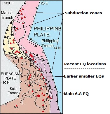
Solidum told ABS-CBNnews.com that the cause of the earthquake was due to subduction.
The following diagram shows where the subducting parts of the tectonics occur in the Philippines. It is interesting that the earlier quakes were mid way between the eastern subduction zone and the main quake. These weren't tremors, but Im beginning to see a pattern. It seems that small quakes near a subduction zone often preclude bigger quakes by up to 24 hours (?)
Concerning my earlier post I was mistaken on timeline of the tremors, as the tremor page is in UTC/GMT and not PST. Soooo....
The actual times for the mid swarm place all of them before the main EQ off BC at 8:05 PM on the 4th. Converting UTC/GMT to PST the first tremor between the onshore swarm and the big quake hit at 11:07 PM the night before the quake, and the rest of the swarm between noon and 1 PM, seven plus hours before the main quake. So the series of tremors began onshore with one occurring offshore, then silence onshore, a series offshore and then the big one.
Haven't had time to compare with any other onshore/offshore tremor series.
It's gotten pretty silent for more than 7 hours now after that big one don't you guys think?
Turkey seems pretty active.. maybe foreshocks
2012-02-06 20:36:27.7
18min ago
39.52 N 33.12 E 5 2.9 CENTRAL TURKEY
2012-02-06 20:24:32.5
30min ago
39.83 N 30.53 E 5 2.8 WESTERN TURKEY
2012-02-06 20:15:51.8
39min ago
38.48 N 39.26 E 9 2.4 EASTERN TURKEY
2012-02-06 19:29:54.7
1hr 25min ago
38.83 N 43.57 E 21 2.4 EASTERN TURKEY
2012-02-06 19:26:03.0
1hr 29min ago
38.70 N 43.46 E 2 3.0 EASTERN TURKEY
2012-02-06 18:39:15.0
2hr 15min ago
38.78 N 43.57 E 5 2.6 EASTERN TURKEY
2012-02-06 17:29:14.0
3hr 25min ago
39.76 N 43.61 E 5 2.5 EASTERN TURKEY
2012-02-06 16:43:41.9
4hr 11min ago
40.68 N 36.88 E 4 2.7 CENTRAL TURKEY
edit on 6-2-2012 by Hellas because: (no reason given)
reply to post by ur44lois
I have no idea, sorry. But the whole geology of the area has been under a lot of stress since before christmas with widespread flooding. I would expect some landslides if the eq's are happening close to the sodden areas.
Personally, I have said several times here on ATS, I think the next big event will be in this region, and could possibly trigger a chain reaction. But I am no volcanologist or seismologist. True american I did ask you a couple of wekks ago if you could throw your eye over this region
And just to get the quirky out of the way......to explain the 'silence'....maybe 'they' have shaken Manila enough into submission?
Rainbows
Jane
Originally posted by Hellas
Magnitude mb 5.7
Region VANUATU
Date time 2012-02-05 16:40:45.8 UTC
Location 17.82 S ; 167.28 E
Depth 40 km
Distances 1180 km W Suva (pop 199,455 ; local time 04:40:45.8 2012-02-06)
109 km W Vila (pop 35,901 ; local time 03:40:45.8 2012-02-06)
EMSC
ETA: Upgraded to 6.3 !!
!! ?? Probably not an upgrade as this was a change from mb to Mw, i.e. change of magnitude scale not of magnitude (probably)
Beware calling changes in scale upgrades. They may be, but first you should check the scientific data and average the mb values from the P wave. The S wave calculation, Mw usually, never comes out first although there are times it is the first value published but if that is the case the version number will usually be 7 or greater.
Apologies for the edumacation lesson.
reply to post by PuterMan
It was 5.7 mb, then got to a 6.3 mw and now it's 6.1 mw as you can see at the link.
ETA: I understand your point and you're right.
It was 5.7 mb, then got to a 6.3 mw and now it's 6.1 mw as you can see at the link.
ETA: I understand your point and you're right.
edit on 6-2-2012 by Hellas because: (no reason given)
reply to post by zworld
Yes, after the event. So now do all swarms precede Mag 9 earthquakes? No they don't.
That out of the way I have been sat on this since September/October of last year since TA asked the question and I need a clever mathematical person to tell me that me calcs are wrong.
Cascadia is well past due for a mag 9 I believe. The geologists say there is a 15% chance of a large earthquake in the next 50 years. Just how exactly do they work that out??
Let's look at some very simple maths.
in 1200 there was a mag 9 quake. The geologists say that exhausted the stress on the fault.
In 1600 there was a mag 9 quake. In 1700 there was a mag 9 quake. A mag 9 quake is 1,998,000 (approx) TJ of energy so just before 1200 there had to be that much stress in the system.
The decade(+) 2000-2010 (11 years) averaged out at a release of 6,132 TJ of energy however we need to find out what value should be input into the system in order to produce two mag 9 earthquakes before 1900, and not at even spreads.
What you have to find is the best match to give as near zero as possible after 1700, on the assumption that 1200 reduced the load to zero.
This is the figure I have come up with.
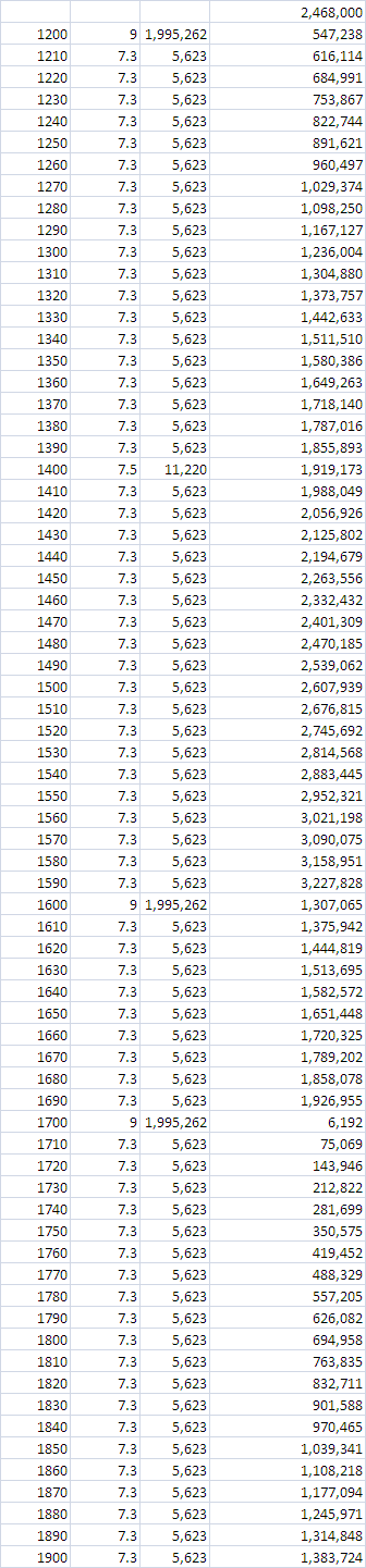
So in order to arrive at the figure we want the stress building in the system such that the input and total output is 0 or there about in 1900. Sorry to repeat but I am trying to be clear on this. This means 74,500 TJ per decade which is massive. The first figure on the list is an 8.65 over the value for a 9 and is needed to keep the figures right.
Now look at the value that we can assume was present as built up stress by 1900 (i.e. since 1700) The stress figure takes account of releases purely by virtue of the fact that the mag 9 earthquakes happened and because I have allowed a mag 7.3 every decade between 1200 to 1900 as that keeps the figure to the lowest in 1700 and gives us a start point for 1900 onwards. A 7.3 is 5,623 TJ of energy. I can't get close to zero using ANY other combinations.
I can't load the next image as it is too big for ATS @ 1MB and over 25,000 pixels long.
If we start with the stress value we have already calculated as the starting point for the load, we are now looking at ACTUAL values. Obviously earlier years may be on the low side but I am ONLY looking at mag 6+ quakes here so it should make little difference. That image is monthly. From 1200 to 1900 gives a monthly stress of 742 TJ per month which is 8900 annually.
That image show that IF this is the stress build then Cascadia reached the required 2 million TJ around 1938. See the revised date
below.
Having said that the first figures would suggest that the region CAN go as much as 3 million TJ before shooting it's load. Using the actual quakes including the 8.1, the stress levels COULD possibly be as high as 2.5 million TJ over the required minimum stress and halfway between the min and known max.
500,000 TJ is the equivalent of a mag 8.6 so theoretically there could be a mag 8.6 foreshock and then still the potential for a mag 9 main shock if it got to that level - and it can,
I sincerely hope I am very very wrong and I would love someone to point out the error in my calcs.
If you want the spreadsheet you can get it here. Cascadia1900-2011.xlsx
I feel relieved to have got that off my chest!!
OK, I found an error (great how publishing makes you find the errors!!), and it does make a difference in that the values are lower.I am not
going to change the images I have updated the one you see. Doing the other now. I have updated the spreadsheet so just download that.
The new figure means Cascadia went past the minimum mag 9 stress potential in 1998 so it is possible any time forwards,
Randomly generating year sets (copying previous years at random) takes it to 2.25 Million TJ by 2036. We are well over a mag 9 in well under 50 years by then.
By the way from 1900 to 2011 the average magnitude equivalent of the stress released was a 6.8 per year.
A 7.3 is 6 times stronger than a 6.8 so 1 7.3 per decade is a bit less than current stress release BUT if you increase the stress release to meet that figure it still makes very little difference. Let's say you double the release. That simply moves the 2 million point from 1998 to 2007. It does not seem to matter what combination you use the point has passed.
Its known that the Tohoku quake was preceded by a swarm.
Yes, after the event. So now do all swarms precede Mag 9 earthquakes? No they don't.
That out of the way I have been sat on this since September/October of last year since TA asked the question and I need a clever mathematical person to tell me that me calcs are wrong.
Cascadia is well past due for a mag 9 I believe. The geologists say there is a 15% chance of a large earthquake in the next 50 years. Just how exactly do they work that out??
Let's look at some very simple maths.
in 1200 there was a mag 9 quake. The geologists say that exhausted the stress on the fault.
In 1600 there was a mag 9 quake. In 1700 there was a mag 9 quake. A mag 9 quake is 1,998,000 (approx) TJ of energy so just before 1200 there had to be that much stress in the system.
The decade(+) 2000-2010 (11 years) averaged out at a release of 6,132 TJ of energy however we need to find out what value should be input into the system in order to produce two mag 9 earthquakes before 1900, and not at even spreads.
What you have to find is the best match to give as near zero as possible after 1700, on the assumption that 1200 reduced the load to zero.
This is the figure I have come up with.
So in order to arrive at the figure we want the stress building in the system such that the input and total output is 0 or there about in 1900. Sorry to repeat but I am trying to be clear on this. This means 74,500 TJ per decade which is massive. The first figure on the list is an 8.65 over the value for a 9 and is needed to keep the figures right.
Now look at the value that we can assume was present as built up stress by 1900 (i.e. since 1700) The stress figure takes account of releases purely by virtue of the fact that the mag 9 earthquakes happened and because I have allowed a mag 7.3 every decade between 1200 to 1900 as that keeps the figure to the lowest in 1700 and gives us a start point for 1900 onwards. A 7.3 is 5,623 TJ of energy. I can't get close to zero using ANY other combinations.
I can't load the next image as it is too big for ATS @ 1MB and over 25,000 pixels long.
If we start with the stress value we have already calculated as the starting point for the load, we are now looking at ACTUAL values. Obviously earlier years may be on the low side but I am ONLY looking at mag 6+ quakes here so it should make little difference. That image is monthly. From 1200 to 1900 gives a monthly stress of 742 TJ per month which is 8900 annually.
Having said that the first figures would suggest that the region CAN go as much as 3 million TJ before shooting it's load. Using the actual quakes including the 8.1, the stress levels COULD possibly be as high as 2.5 million TJ over the required minimum stress and halfway between the min and known max.
500,000 TJ is the equivalent of a mag 8.6 so theoretically there could be a mag 8.6 foreshock and then still the potential for a mag 9 main shock if it got to that level - and it can,
I sincerely hope I am very very wrong and I would love someone to point out the error in my calcs.
If you want the spreadsheet you can get it here. Cascadia1900-2011.xlsx
I feel relieved to have got that off my chest!!
OK, I found an error (great how publishing makes you find the errors!!), and it does make a difference in that the values are lower.
The new figure means Cascadia went past the minimum mag 9 stress potential in 1998 so it is possible any time forwards,
Randomly generating year sets (copying previous years at random) takes it to 2.25 Million TJ by 2036. We are well over a mag 9 in well under 50 years by then.
edit on 6/2/2012 by PuterMan because: (no reason given)
By the way from 1900 to 2011 the average magnitude equivalent of the stress released was a 6.8 per year.
A 7.3 is 6 times stronger than a 6.8 so 1 7.3 per decade is a bit less than current stress release BUT if you increase the stress release to meet that figure it still makes very little difference. Let's say you double the release. That simply moves the 2 million point from 1998 to 2007. It does not seem to matter what combination you use the point has passed.
edit on 6/2/2012 by PuterMan because: (no reason given)
Just for interest sake, I subscribe to a psychic that does weekly predictions, and though he's never 100% correct, he does get many right. This week
he mentioned the following:
I predict a major tremor will strike California near the middle of this month.
I really hope this is one of those times that he's WRONG.
I predict a major tremor will strike California near the middle of this month.
I really hope this is one of those times that he's WRONG.
Originally posted by SpaceJockey1
Just for interest sake, I subscribe to a psychic that does weekly predictions, and though he's never 100% correct, he does get many right. This week he mentioned the following:
I predict a major tremor will strike California near the middle of this month.
I really hope this is one of those times that he's WRONG.
That's interesting. I've read a few "theories" and prophecies since early Jan that have targeted the west coast of the US. Peeling back before 2012 there are dozens of videos and such doing the same. I think it's largely confined to select groups of the population in NA dreaming these things. So many people in the country, it has to happen. I don't doubt all psychic feelings though. I just think we get hints that synchronize at times, while most of it is all cloudy and fragmented.
I am interested though. I've never had a dream of an earthquake nor have I ever experienced one. I had a dream of a tsunami late last year that was chilling. The location wasn't revealed but the most clear part of the dream was after the tsunami waves. I was using one of those glider suits to travel over the Pacific ocean as water swells attacked little islands, so I assume from this ending that it was somewhere near the ring of fire. .
There was a feeling of devastating in my dream. I awoke in a bit of a panic, dehydrated after sleeping for almost 30 hours. Definitely an intense experience considering I never took a sleeping pill or anything. I've never slept that much in my entire life and I can't recall even waking up, just a complete descent to dream world for hours.
I read somewhere (not sure if it was posted here), of these two women in Mexico who were going to a meeting or presentation of something to do with astronomy. They arrive and the building was blocked off. They found another way in the building and there was this conference going on between many people from around the world saying that Ensenada could be wiped out by waves. I don't know how legit it is, but another for the list.
Seem to be a lot of tremors and a few larger quakes near the Caribbean plate that stealth by near Baja and Ensenada to near Guatemala City. Imagining the plates at work is creepy.
edit on 6/2/12 by murkraz because: (no reason given)
reply to post by The Great Day
Got a link to a picture showing some Active Faults of Negros and Cebu.
Still problems exist here. Poor maping of fault lines. Just have a look at this picture.
www.philippinenewsdaily.com...
Got a link to a picture showing some Active Faults of Negros and Cebu.
Still problems exist here. Poor maping of fault lines. Just have a look at this picture.
The 6.9-magnitude earthquake that jolted Western and Central Visayas Monday, February 6, 2012 has led to the discovery of a new fault line by Phivolcs. Aside from the active Marikina Fault line, Phivolcs found out from yesterday’s tremor that another unmapped fault line is lying beneath the Island of Negros down to Cebu. The government volcanologists yesterday said the new fault line’s unexpected movement has triggered the strong tremor to occur yesterday. Because of this, Phivolcs is expected to release an updated fault line map in the country.
www.philippinenewsdaily.com...
M 4.9, NEGROS - CEBU REGION, PHILIPPINES February 7, 2012 04:05:38 UTC February 7, 2012 12:05:38 local time at epicenter Lat: 10.2967 Lon: 123.1899 Depth: 10 km (6.2 mi)
The quakes are moving towards Kanlaon Volcano (just 14-15km from the epicenter), so just to let it be known. A controversy was sparked in the Philippines when 20 earthquakes were felt soon after drilling for a new geothermal prospect on Kanlaon Volcano. As said before,most of its eruptions produce VEI 1 or 2 explosive events with minor ash and phreatic explosions, but it has erupted at least 5 times in the last decade.
PHIVOLCS thinks that the volcano is not headed towards eruption and that the tremors – whatever the cause – are not the result of the drillings as part of the Northern Negros Geothermal Production Field.
Do anyone here know for sertain whether drilling into areas of active magmatism might actually cause volcanism?
Originally posted by PuterMan
reply to post by zworld
Its known that the Tohoku quake was preceded by a swarm.
Yes, after the event. So now do all swarms precede Mag 9 earthquakes? No they don't.
PuterMan, do you have knowledge of a Japanese site that monitors tremors like PNSN. Ive been looking. Would love the link if so.
ON EDIT: Nevermind, I found it. Its called HiNet. www.hinet.bosai.go.jp...
By the way, I shouldn't have said swarm. Any cluster or even single tremor could be predictive. The article I read stated preceded by but Im going to go through HiNet and see whats shaking (no pun intended).
edit on 7-2-2012 by zworld because: (no reason given)
Is there anyone who knows Japanese. Im trying to find how to manipulate this page to show a readout of March 9th, 10th, 11th and 12th, 2011, to see if
there are any patterns of tremors before or after the Tohoku EQ. Japan looks like it gets many times the tremor activity we get here in the CSZ. I
dont know Japanese so this may be wrong but the last two days had over 80,000 tremors and that's about the average, with the majority on the eastern
seaboard of Japan. The longest ETS ever lasted 5 years and was at Tokai south of Fukushima.
Would love to figure out where I need to enter what to get different dates.
www.hinet.bosai.go.jp...
Would love to figure out where I need to enter what to get different dates.
www.hinet.bosai.go.jp...
reply to post by zworld
good find.
No I don't read japanese, and I'm sure I looked at that site before, but never could figure out how it worked, I've never seen these maps before.
If you click on the various options in the drop down boxes you can get 24hrs, 7 days and 30 days, but you probably know that.
Holy cow, they get a truckload don't they, I had no idea it was 380/day (last 24hrs)
I decided to download the 30 day map, it had N=15823 on it
by the time I did that and saved it to Dropbox and went back to the page it had N=16252
maybe it was just update time, surely they didn't just have 400 odd more in 10 minutes
here be the 30 day the map
well it was
edit on 7-2-2012 by muzzy because: (no reason given)
reply to post by Roald
Wow new fault line goes right down the spine of Cebu Island past the Philippines second biggest city. That city would get flattened if it got a direct hit, wife still feeling aftershocks on Lapu-Lapu.....feeling dizzy when it happens.
Wow new fault line goes right down the spine of Cebu Island past the Philippines second biggest city. That city would get flattened if it got a direct hit, wife still feeling aftershocks on Lapu-Lapu.....feeling dizzy when it happens.
reply to post by The Great Day
said on the TV News here in New Zealand that there had been 200 aftershocks (and that was 3.5 hrs ago).
only 27 shown on Philippine Institute of Volcanology and Seismology @ this point in time
said on the TV News here in New Zealand that there had been 200 aftershocks (and that was 3.5 hrs ago).
only 27 shown on Philippine Institute of Volcanology and Seismology @ this point in time
edit on 7-2-2012 by muzzy because: (no reason given)
reply to post by zworld
This page seems to be about the slip.
www.hinet.bosai.go.jp...
Can't see anywhere on the page you linked where you get more than 30 days of data.
This page seems to be about the slip.
www.hinet.bosai.go.jp...
Can't see anywhere on the page you linked where you get more than 30 days of data.
edit on 7/2/2012 by PuterMan because: (no reason given)
Magnitude 5.3, Tuesday, February 7 2012 at 11:21 pm (NZDT), 30 km west of Taumarunui, North Island, New Zealand
Depth 250km
Felt Map: www.geonet.org.nz...
Depth 250km
Felt Map: www.geonet.org.nz...
new topics
-
Louisiana Lawmakers Seek to Limit Public Access to Government Records
Political Issues: 2 hours ago -
The Tories may be wiped out after the Election - Serves them Right
Regional Politics: 3 hours ago -
So I saw about 30 UFOs in formation last night.
Aliens and UFOs: 5 hours ago -
Do we live in a simulation similar to The Matrix 1999?
ATS Skunk Works: 6 hours ago -
BREAKING: O’Keefe Media Uncovers who is really running the White House
US Political Madness: 6 hours ago -
Biden--My Uncle Was Eaten By Cannibals
US Political Madness: 7 hours ago -
"We're All Hamas" Heard at Columbia University Protests
Social Issues and Civil Unrest: 7 hours ago -
The good, the Bad and the Ugly!
Diseases and Pandemics: 9 hours ago
top topics
-
BREAKING: O’Keefe Media Uncovers who is really running the White House
US Political Madness: 6 hours ago, 21 flags -
Biden--My Uncle Was Eaten By Cannibals
US Political Madness: 7 hours ago, 18 flags -
African "Newcomers" Tell NYC They Don't Like the Free Food or Shelter They've Been Given
Social Issues and Civil Unrest: 13 hours ago, 12 flags -
Two Serious Crimes Committed by President JOE BIDEN that are Easy to Impeach Him For.
US Political Madness: 15 hours ago, 8 flags -
911 emergency lines are DOWN across multiple states
Breaking Alternative News: 15 hours ago, 7 flags -
"We're All Hamas" Heard at Columbia University Protests
Social Issues and Civil Unrest: 7 hours ago, 7 flags -
Russia Flooding
Fragile Earth: 14 hours ago, 6 flags -
Russian intelligence officer: explosions at defense factories in the USA and Wales may be sabotage
Weaponry: 12 hours ago, 5 flags -
So I saw about 30 UFOs in formation last night.
Aliens and UFOs: 5 hours ago, 4 flags -
Do we live in a simulation similar to The Matrix 1999?
ATS Skunk Works: 6 hours ago, 3 flags
active topics
-
Revolution in advertising: the Russians launched a unique satellite
Science & Technology • 73 • : purplemer -
"We're All Hamas" Heard at Columbia University Protests
Social Issues and Civil Unrest • 81 • : hangedman13 -
Candidate TRUMP Now Has Crazy Judge JUAN MERCHAN After Him - The Stormy Daniels Hush-Money Case.
Political Conspiracies • 353 • : YourFaceAgain -
Do we live in a simulation similar to The Matrix 1999?
ATS Skunk Works • 17 • : purplemer -
Biden--My Uncle Was Eaten By Cannibals
US Political Madness • 36 • : YourFaceAgain -
So I saw about 30 UFOs in formation last night.
Aliens and UFOs • 14 • : Ophiuchus1 -
Sol Et Luna - TIME2024
Short Stories • 9 • : Encia22 -
British TV Presenter Refuses To Use Guest's Preferred Pronouns
Education and Media • 59 • : Consvoli -
Former NYT Reporter Attacks Scientists For Misleading Him Over COVID Lab-Leak Theory
Education and Media • 8 • : Consvoli -
MULTIPLE SKYMASTER MESSAGES GOING OUT
World War Three • 27 • : Zaphod58