It looks like you're using an Ad Blocker.
Please white-list or disable AboveTopSecret.com in your ad-blocking tool.
Thank you.
Some features of ATS will be disabled while you continue to use an ad-blocker.

Quake Watch 2012
page: 283share:
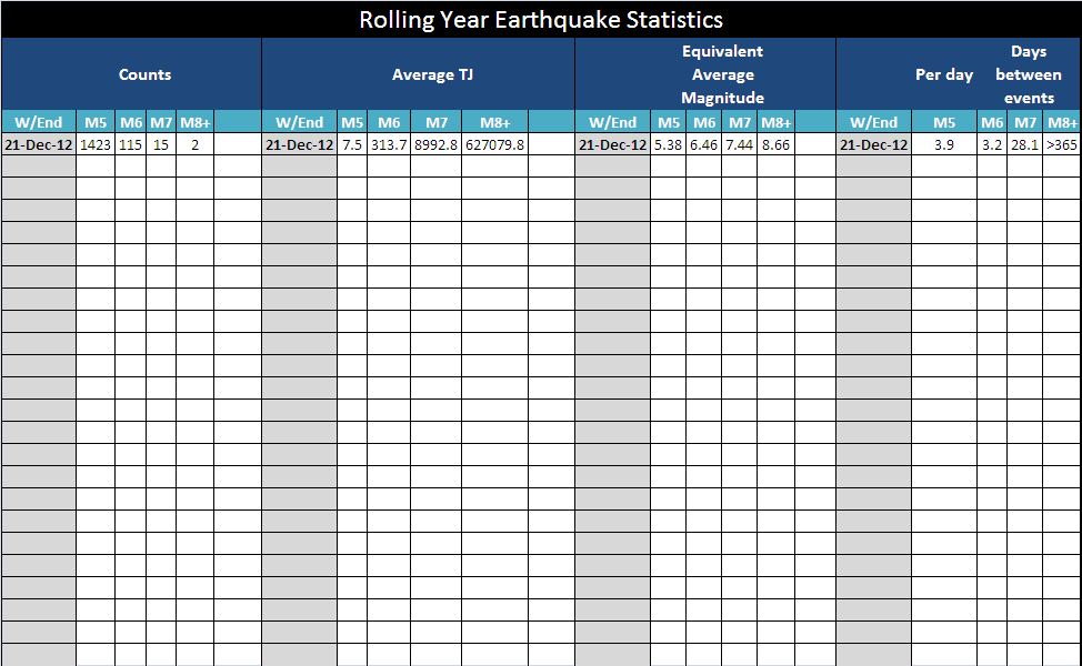
A taster of the Weekly Geophysical report that will be coming to ATS soon. Just thought you might like to see the earthquake stats. These are for a
rolling 365 day period compiled weekly.
I shall use this post as an explanation of this part of the report, so.....
There are 4 sections:
Mag 8 and 9 if present are added in the same band.
Any of these figures may change slightly as magnitudes are re-jigged by USGS. As the quakes drop off the front (older than 365 days) the averages will change according to the new rolling year value. Once there are a few weekly values I shall plot the values so we can see how the rolling year values are trending. This will become a useful figure after about 6 months have gone by.
I shall use this post as an explanation of this part of the report, so.....
There are 4 sections:
- The count of the number of quakes in the past 365/6 days for each mag band
- The approximate average TeraJoules per quake for each mag band
- The equivalent of this energy as a magnitude (not the same as averaging the magnitudes)
- The number of days on average between events, except Mag 5 band where it is the number of events in a day on average.
Mag 8 and 9 if present are added in the same band.
Any of these figures may change slightly as magnitudes are re-jigged by USGS. As the quakes drop off the front (older than 365 days) the averages will change according to the new rolling year value. Once there are a few weekly values I shall plot the values so we can see how the rolling year values are trending. This will become a useful figure after about 6 months have gone by.
edit on 23/12/2012 by PuterMan because: Darn it can I not get just ONE post without a spelling error? Humph!
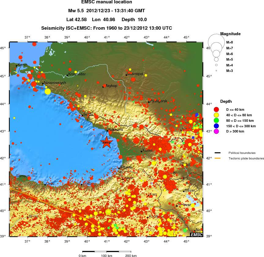
Kinda in a unusual spot if you look at the quake history in that area.
Earthquake Details
This event has been reviewed by a seismologist.
Magnitude
5.8
Date-Time
Sunday, December 23, 2012 at 13:31:42 UTC
Sunday, December 23, 2012 at 05:31:42 PM at epicenter
Time of Earthquake in other Time Zones
Location
42.470°N, 41.007°E
Depth
18.7 km (11.6 miles)
Region
BLACK SEA, OFFSHORE GEORGIA
Distances
46 km (28 miles) SW of Och'amch'ire, Georgia
59 km (36 miles) S of Sokhumi, Georgia
62 km (38 miles) WSW of Gali, Georgia
65 km (40 miles) WNW of P'ot'i, Georgia
USGS
Somehow I have a bad feeling. It seems a bit too quiet the last 2 days. I don't know, maybe Puterman can shed some light. I am missing a few 5.5+
ones...
reply to post by PuterMan
I love it, PM! Especially the "days since last event" column; so when we are feeling "it's eerily quiet", we can easily see if that is actually the case.
Will this be a daily update in the Quake Watch thread, or will it be on your site?
I love it, PM! Especially the "days since last event" column; so when we are feeling "it's eerily quiet", we can easily see if that is actually the case.
Will this be a daily update in the Quake Watch thread, or will it be on your site?
reply to post by lurksoften
It was revised down 5.5
Earthquake Details
This event has been reviewed by a seismologist.
Magnitude
5.5
Date-Time
Sunday, December 23, 2012 at 13:31:39 UTC
Sunday, December 23, 2012 at 05:31:39 PM at epicenter
Time of Earthquake in other Time Zones
Location
42.417°N, 41.064°E
Depth
10 km (6.2 miles) set by location program
Region
BLACK SEA, OFFSHORE GEORGIA
Distances
46 km (28 miles) SW of Och'amch'ire, Georgia
59 km (36 miles) S of Sokhumi, Georgia
62 km (38 miles) WSW of Gali, Georgia
65 km (40 miles) WNW of P'ot'i, Georgia
USGS
Colombia maps 2012
14 maps
RSNC have recorded 12,856 events and ANSShave 506 mag 5+ going back to 1963
or maybe the title should be
" what the heck is going on at LOS SANTOS, SANTANDER"
its a Gypsum mining area, but the depths don't add up 140-150km, surely they don't mine gypsum that deep, it would be hot as Hades at that depth
there are hundreds of quakes there every month
edit on 23-12-2012 by muzzy because: (no reason given)
reply to post by lurksoften
yeah not much in that area from historic times either (pre 1900) Utsu
been a few aftershocks (8), RAS will log them, too small for USGS
map of them so far, they seem to be heading towards the coast of Georgia
www.ceme.gsras.ru...
damn RAS has gone off line
yeah not much in that area from historic times either (pre 1900) Utsu
been a few aftershocks (8), RAS will log them, too small for USGS
map of them so far, they seem to be heading towards the coast of Georgia
www.ceme.gsras.ru...
edit on 23-12-2012 by muzzy because: (no reason given)
damn RAS has gone off line
edit on 23-12-2012 by muzzy because: (no reason given)
reply to post by muzzy
Close to several centres of activity however.
This is one for a European organisation. The USGS is useless fro this sort of area.
Close to several centres of activity however.
Prov,Date/Time UTC,Latitude,Longitude,Magnitude,Depth(Km),Location
emsc,2012-12-23 22:05:13, 42.338, 40.965, 3.0, 2.0, Black Sea Offshore Georgia
emsc,2012-12-23 19:32:57, 42.372, 40.977, 3.3, 2.0, Black Sea Offshore Georgia
emsc,2012-12-23 19:12:47, 42.343, 40.996, 2.6, 15.0, Black Sea Offshore Georgia
emsc,2012-12-23 18:22:00, 42.342, 40.962, 2.9, 10.0, Black Sea Offshore Georgia
emsc,2012-12-23 18:00:09, 42.439, 41.026, 2.7, 20.0, Black Sea Offshore Georgia
emsc,2012-12-23 17:32:38, 42.455, 41.011, 2.5, 15.0, Black Sea Offshore Georgia
emsc,2012-12-23 16:49:45, 42.471, 41.158, 2.8, 30.0, Black Sea Offshore Georgia
emsc,2012-12-23 15:18:35, 42.358, 40.881, 3.9, 2.0, Black Sea Offshore Georgia
emsc,2012-12-23 15:15:23, 42.407, 41.049, 3.3, 25.0, Black Sea Offshore Georgia
emsc,2012-12-23 15:09:15, 42.354, 40.821, 3.4, 2.0, Black Sea Offshore Georgia
emsc,2012-12-23 14:18:43, 42.387, 40.871, 3.8, 10.0, Black Sea Offshore Georgia
emsc,2012-12-23 13:54:04, 42.334, 41.019, 3.5, 10.0, Black Sea Offshore Georgia
emsc,2012-12-23 13:50:43, 42.385, 41.070, 3.1, 30.0, Black Sea Offshore Georgia
emsc,2012-12-23 13:48:43, 42.337, 40.948, 3.3, 2.0, Black Sea Offshore Georgia
emsc,2012-12-23 13:42:50, 42.347, 40.578, 3.1, 20.0, Black Sea Offshore Georgia
emsc,2012-12-23 13:31:40, 42.580, 40.987, 5.5, 10.0, Black Sea Offshore Georgia
This is one for a European organisation. The USGS is useless fro this sort of area.
edit on 23/12/2012 by PuterMan because: (no reason given)
Originally posted by Olivine
reply to post by PuterMan
I love it, PM! Especially the "days since last event" column; so when we are feeling "it's eerily quiet", we can easily see if that is actually the case.
Will this be a daily update in the Quake Watch thread, or will it be on your site?
Hi Olivine, thanks. What it actually is is "The number of days on average between events, except Mag 5 band where it is the number of events in a day on average. " but yup I like the idea of days since last event so I shall add another table for that.
There will be a full version on my site and a restricted version on ATS, purely because of the serious limitations that have been imposed on the length of a post, and I hate posts spit up across many. It will be in a weekly geophysical thread along the lines of the T-xx and counting that I have been running.
There are 8000 characters in the first one and I have hardly even got going yet. One liners? Pshhhhhhh!
reply to post by aLLeKs
It probably depends upon who you look at, and this is a difficulty with reporting as well.
USGS for today and the previous 7 days - Mag 5 band
19 events.
EMSC for the same parameters
26 events - a difference of 7 which at the Mag 5 level is quite substantial considering USGS say they gather everything over 4.5. I have not check but it is probably some < 5 on USGS that have sneaked into 5+ on EMSC.
contined in next post due to severe limitations on creative expression!
It probably depends upon who you look at, and this is a difficulty with reporting as well.
USGS for today and the previous 7 days - Mag 5 band
Prov,Date/Time UTC,Latitude,Longitude,Magnitude,Depth(Km),Location
usgs,2012-12-23 13:31:39, 42.417, 41.063, 5.5, 10.0, Black Sea. Offshore Georgia
usgs,2012-12-23 12:52:23, 4.171, 126.633, 5.2, 31.9, Kepulauan Talaud. Ind.
usgs,2012-12-23 06:38:57, 38.504, 44.844, 5.2, 10.5, Turkey-Iran Border Region
usgs,2012-12-23 00:29:55, -13.079, 167.113, 5.2, 211.0, Vanuatu
usgs,2012-12-22 18:07:17, 19.172, 121.088, 5.1, 29.0, Babuyan Isls. Region. Philippines
usgs,2012-12-22 16:41:44, 22.430, 94.753, 5.5, 126.6, Myanmar
usgs,2012-12-22 04:42:37, 49.862, 155.144, 5.1, 117.2, Kuril Isls.
usgs,2012-12-22 03:50:03, 5.234, 94.266, 5.2, 10.0, Northern Sumatra. Ind.
usgs,2012-12-21 14:43:37, 29.842, 142.215, 5.0, 20.3, Izu Isls. Japan Region
usgs,2012-12-21 08:07:18, 38.601, 141.911, 5.0, 35.3, Nr. E. Coast Of Honshu. Japan
usgs,2012-12-20 21:47:30, 0.546, 126.232, 5.6, 31.2, Molucca Sea
usgs,2012-12-20 19:38:46, -20.773, -174.088, 5.0, 45.1, Tonga
usgs,2012-12-19 16:02:20, -20.472, -174.331, 5.0, 9.9, Tonga
usgs,2012-12-18 18:36:24, 36.678, 142.013, 5.1, 33.5, Off E. Coast Of Honshu. Japan
usgs,2012-12-18 08:12:24, 13.028, -89.991, 5.1, 57.5, Offshore El Salvador
usgs,2012-12-17 22:52:23, 37.765, 143.597, 5.0, 47.3, Off E. Coast Of Honshu. Japan
usgs,2012-12-17 17:46:48, -3.968, -104.037, 5.1, 15.7, Central East Pacific Rise
usgs,2012-12-17 17:41:36, -4.107, -104.416, 5.1, 35.7, Central East Pacific Rise
usgs,2012-12-17 00:28:55, 49.749, 155.952, 5.6, 38.9, Kuril Isls.
19 events.
EMSC for the same parameters
Prov,Date/Time UTC,Latitude,Longitude,Magnitude,Depth(Km),Location
emsc,2012-12-23 13:31:40, 42.580, 40.987, 5.5, 10.0, Black Sea Offshore Georgia
emsc,2012-12-23 12:52:25, 4.225, 126.722, 5.2, 49.0, Kepulauan Talaud Ind.
emsc,2012-12-23 00:29:57, -13.089, 167.148, 5.2, 230.0, Vanuatu
emsc,2012-12-22 18:07:19, 19.126, 121.221, 5.1, 50.0, Babuyan Isl Region Philippines
emsc,2012-12-22 16:41:45, 22.469, 94.801, 5.5, 133.0, Myanmar
emsc,2012-12-22 16:02:45, -5.976, -76.578, 5.0, 40.0, Northern Peru
emsc,2012-12-22 04:42:37, 49.864, 155.137, 5.1, 123.0, Kuril Isls.
emsc,2012-12-22 03:50:03, 5.259, 94.167, 5.3, 10.0, Northern Sumatra Ind.
emsc,2012-12-22 03:24:34, 22.047, 121.481, 5.4, 16.0, Taiwan Region
emsc,2012-12-22 02:04:23, -2.826, 119.859, 5.1, 40.0, Sulawesi Ind.
emsc,2012-12-21 14:43:35, 29.718, 142.264, 5.0, 10.0, Izu Isls. Japan Region
emsc,2012-12-21 08:07:18, 38.683, 141.732, 5.1, 35.0, Nr. E. Coast Of Honshu Japan
emsc,2012-12-21 01:45:18, -20.768, -174.020, 5.0, 30.0, Tonga
emsc,2012-12-20 21:47:30, 0.615, 126.309, 5.6, 30.0, Molucca Sea
emsc,2012-12-20 19:38:45, -20.672, -174.079, 5.0, 40.0, Tonga
emsc,2012-12-19 16:08:30, 28.861, 171.684, 5.7, 10.0, North Pacific Ocean
emsc,2012-12-19 16:02:19, -20.573, -174.124, 5.0, 10.0, Tonga
emsc,2012-12-19 11:51:51, -18.991, -175.532, 5.0, 223.0, Tonga
emsc,2012-12-19 10:25:57, -28.915, 61.948, 5.0, 10.0, S.West Indian Ridge
emsc,2012-12-18 18:36:21, 36.701, 142.024, 5.1, 10.0, Off E. Coast Of Honshu Japan
emsc,2012-12-18 08:12:25, 13.095, -89.918, 5.0, 70.0, Offshore El Salvador
emsc,2012-12-17 22:52:22, 37.764, 143.574, 5.0, 38.0, Off E. Coast Of Honshu Japan
emsc,2012-12-17 17:46:47, -4.010, -104.142, 5.7, 10.0, Central East Pacific Rise
emsc,2012-12-17 17:41:32, -4.130, -104.557, 5.8, 10.0, Central East Pacific Rise
emsc,2012-12-17 11:28:43, -30.912, -178.122, 5.0, 2.0, Kermadec Isls. Nz
emsc,2012-12-17 00:28:56, 49.793, 155.913, 5.6, 44.0, Kuril Isls.
26 events - a difference of 7 which at the Mag 5 level is quite substantial considering USGS say they gather everything over 4.5. I have not check but it is probably some < 5 on USGS that have sneaked into 5+ on EMSC.
contined in next post due to severe limitations on creative expression!
Even Potsdam manage 23
BTW, EMSC is good for South American quakes since unlike both Potsdam and USGS it has a feed from Chile, Peru and Argentina that I am aware of. There may be others.
South America is the new Europe!
Prov,Date/Time UTC,Latitude,Longitude,Magnitude,Depth(Km),Location
gfzp,2012-12-23 13:31:41, 42.590, 40.980, 5.8, 8.0, Black Sea
gfzp,2012-12-23 12:52:22, 4.250, 126.740, 5.2, 27.0, Talaud Isls. Ind.
gfzp,2012-12-23 00:29:58, -13.150, 167.080, 5.1, 230.0, Vanuatu Isls.
gfzp,2012-12-22 18:07:15, 19.130, 121.230, 5.0, 10.0, Philippine Isls. Region
gfzp,2012-12-22 16:41:46, 22.420, 94.730, 5.4, 131.0, Myanmar
gfzp,2012-12-22 04:42:38, 49.820, 155.270, 5.0, 125.0, Kuril Isls.
gfzp,2012-12-22 03:50:04, 5.150, 94.110, 5.1, 10.0, Northern Sumatra. Ind.
gfzp,2012-12-21 14:43:36, 29.700, 142.220, 5.0, 12.0, S.East Of Honshu. Japan
gfzp,2012-12-21 08:07:20, 38.630, 141.810, 5.1, 49.0, Nr. E. Coast Of Honshu. Japan
gfzp,2012-12-21 01:45:15, -20.690, -173.730, 5.1, 10.0, Tonga Isls.
gfzp,2012-12-20 21:47:33, 0.590, 126.270, 5.3, 52.0, Northern Molucca Sea
gfzp,2012-12-20 19:38:40, -20.710, -173.710, 5.1, 10.0, Tonga Isls.
gfzp,2012-12-20 09:31:36, 37.950, 143.950, 5.0, 10.0, Off E. Coast Of Honshu. Japan
gfzp,2012-12-19 16:02:18, -21.210, -173.850, 5.0, 10.0, Tonga Isls.
gfzp,2012-12-19 11:51:52, -18.980, -175.640, 5.0, 225.0, Tonga Isls.
gfzp,2012-12-19 10:25:57, -29.090, 62.040, 5.0, 10.0, S.West Indian Ridge
gfzp,2012-12-18 18:36:25, 36.710, 141.990, 5.1, 33.0, Nr. E. Coast Of Honshu. Japan
gfzp,2012-12-18 08:12:25, 13.190, -89.860, 5.0, 63.0, El Salvador
gfzp,2012-12-17 22:52:22, 37.860, 143.500, 5.0, 32.0, Off E. Coast Of Honshu. Japan
gfzp,2012-12-17 17:46:49, -4.130, -104.070, 5.1, 10.0, Central East Pacific Rise
gfzp,2012-12-17 17:41:33, -4.160, -104.480, 5.9, 10.0, Central East Pacific Rise
gfzp,2012-12-17 11:28:51, -30.800, -178.240, 5.1, 63.0, Kermadec Isls. Nz
gfzp,2012-12-17 00:28:57, 49.710, 156.150, 5.5, 47.0, Kuril Isls.
BTW, EMSC is good for South American quakes since unlike both Potsdam and USGS it has a feed from Chile, Peru and Argentina that I am aware of. There may be others.
South America is the new Europe!
edit on 23/12/2012 by PuterMan because: (no reason given)
reply to post by Olivine
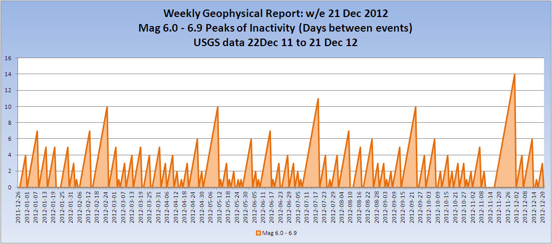
Here is an interesting chart of your suggestion. Days since last activity (or Peaks Of Inactivity) for Mag 6.0 to 6.9 quakes.
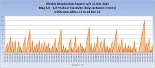
@Phoenix - notice any patterns?
Weekly Geophysical report thread started now. All suggestions welcome and will be considered depending on time available. See my signature for link.
Here is an interesting chart of your suggestion. Days since last activity (or Peaks Of Inactivity) for Mag 6.0 to 6.9 quakes.
@Phoenix - notice any patterns?
Weekly Geophysical report thread started now. All suggestions welcome and will be considered depending on time available. See my signature for link.
edit on 24/12/2012 by PuterMan because: (no reason given)
reply to post by PuterMan
I really like it PM. Your new weekly update thread will become a great resource for us. Thanks.
I really like it PM. Your new weekly update thread will become a great resource for us. Thanks.
Earthquake at 8:28a.m. measured at 4.1 magnitude. Cook Inlet has been very active with over a dozen minor tremors since midnight.
This was in Anchorage Alaska.
This was in Anchorage Alaska.
edit on 24-12-2012 by sandman441 because: (no reason given)
reply to post by PuterMan
Thats a good indicator of a trend of something if I ever did see one.
So how does it match up with anything else I wonder? moon phases, solar flares etc
its a pretty regular pattern
like I used to say about NZ quakes its when there is nothing happening that may be more important than counting the actual 5's or whatever. I used to see a drop in numbers on Geonet and soon after there would be a mag 5+, but since the SeisComp3 was introduced the numbers are around average 50 preliminary events per day, so you can't really see a drop off any more. And since the geologist at Geonet said the number of reviewed quakes cannot be an indicator either, because it is more about the duty officers mood and field of interest on which ones are reviewed.
I know your quandary about which network to use, as always each one is different, and the title should always be "# quakes recorded by XYZ Network" not a "this is all the mag 5's in the World" type name. The there is the is it a 4.9 or a 5.0 issue. But you know that.
I notice your EMSC had 3 decimal places, how did you get that?
One reason I have never used EMSC much is the grid like icon pattern you end up with on the maps using their 2 decimal place Lat/Long
I haven't had any EMSC or GFZ data on QVS DataPro for over a month, I think its broken.
edit on 24-12-2012 by muzzy because: (no reason
given)
I know there is 6 days left yet but;
Chile 2012
14 maps
mag1= 54
mag2= 1,391
mag3= 2,680
mag4= 641
mag5= 79
mag6= 7
mag7= 0
Total number= 4852
TTNT= 613,188.789 energy released
not as many total as say Japan, Greece, Colombia, NZ or Turkey, but look at the # of 5's and 6's, and thats without a 7 to push up the numbers with aftershocks.
There are obviously more 1's than they show, too bad they don't publish those, I bet you could add a couple of 00's to that grand total if they did.
I'll be tabling and graphing that soon, Dec way down on the other months, could be they haven't loaded everything to the database yet, or it could be the tension building.
I used the search facility www.sismologia.cl... they had quite a few more than on the daily lists.
edit on 24-12-2012 by muzzy because: (no reason given)
reply to post by muzzy
This is the data/no data quandary. If you miss a day or two and go past the collection count it stops collecting data. You need to do a single provider download in the Data centre to get it going again. I think I am going to have to change it so it does not do that unless you are on the service mode.
You should get a question asking it it is OK to continue with no existing values. Answer yes.
EMSC has 4 decimal places when you download and extract the KML version of the data which is what QVSData does. The KML is the only listing that has their reference numbers in it without doing a screen scrape. The listing of USGS, EMSC and GFZ is rounded to 3 decimals on that output which is the 'forum' list. The CSV to clipboard output will show 5 decimal places if available (GeoNet).
ETA: The little buttony things decided to take Christmas off on the Chile maps.
I haven't had any EMSC or GFZ data on QVS DataPro for over a month, I think its broken.
This is the data/no data quandary. If you miss a day or two and go past the collection count it stops collecting data. You need to do a single provider download in the Data centre to get it going again. I think I am going to have to change it so it does not do that unless you are on the service mode.
You should get a question asking it it is OK to continue with no existing values. Answer yes.
I notice your EMSC had 3 decimal places, how did you get that?
EMSC has 4 decimal places when you download and extract the KML version of the data which is what QVSData does. The KML is the only listing that has their reference numbers in it without doing a screen scrape. The listing of USGS, EMSC and GFZ is rounded to 3 decimals on that output which is the 'forum' list. The CSV to clipboard output will show 5 decimal places if available (GeoNet).
edit on 24/12/2012 by PuterMan because: (no reason given)
ETA: The little buttony things decided to take Christmas off on the Chile maps.
edit on 24/12/2012 by PuterMan because: (no reason given)
Hey puterman, I just had a few... ok a lot... of drinks with my family, because of christmas. but thank you for your work... but still it seems really
quiet... ok I only watch 5+ ones at usgs but still,... way to quiet
Happy Christmas all.
I have asked Muzzy to host Quake Watch 2013. As a major contributor to the thread it is only right and proper that he should have a go at the helm.
I hope that he will agree and that we will see the Quake Watch 2013 thread up and running in a day or so.
I have asked Muzzy to host Quake Watch 2013. As a major contributor to the thread it is only right and proper that he should have a go at the helm.
I hope that he will agree and that we will see the Quake Watch 2013 thread up and running in a day or so.
reply to post by PuterMan
OK I'll give that a try, need to get it up and running to do the end of December data for USGS mainly.
Yeah the Internet was pretty busy yesterday, stuff like that ( map popups) takes forever to work.
Seems to be working OK this end now.
OK I'll give that a try, need to get it up and running to do the end of December data for USGS mainly.
Yeah the Internet was pretty busy yesterday, stuff like that ( map popups) takes forever to work.
Seems to be working OK this end now.
new topics
-
Are you ready for the return of Jesus Christ? Have you been cleansed by His blood?
Religion, Faith, And Theology: 34 minutes ago -
Chronological time line of open source information
History: 1 hours ago -
A man of the people
Diseases and Pandemics: 3 hours ago -
Ramblings on DNA, blood, and Spirit.
Philosophy and Metaphysics: 3 hours ago -
4 plans of US elites to defeat Russia
New World Order: 4 hours ago -
Thousands Of Young Ukrainian Men Trying To Flee The Country To Avoid Conscription And The War
Other Current Events: 8 hours ago -
12 jurors selected in Trump criminal trial
US Political Madness: 11 hours ago -
Iran launches Retalliation Strike 4.18.24
World War Three: 11 hours ago -
Israeli Missile Strikes in Iran, Explosions in Syria + Iraq
World War Three: 11 hours ago
top topics
-
George Knapp AMA on DI
Area 51 and other Facilities: 17 hours ago, 26 flags -
Israeli Missile Strikes in Iran, Explosions in Syria + Iraq
World War Three: 11 hours ago, 17 flags -
Thousands Of Young Ukrainian Men Trying To Flee The Country To Avoid Conscription And The War
Other Current Events: 8 hours ago, 6 flags -
Iran launches Retalliation Strike 4.18.24
World War Three: 11 hours ago, 6 flags -
Not Aliens but a Nazi Occult Inspired and then Science Rendered Design.
Aliens and UFOs: 17 hours ago, 5 flags -
12 jurors selected in Trump criminal trial
US Political Madness: 11 hours ago, 4 flags -
4 plans of US elites to defeat Russia
New World Order: 4 hours ago, 2 flags -
A man of the people
Diseases and Pandemics: 3 hours ago, 2 flags -
Chronological time line of open source information
History: 1 hours ago, 2 flags -
Ramblings on DNA, blood, and Spirit.
Philosophy and Metaphysics: 3 hours ago, 1 flags
active topics
-
4 plans of US elites to defeat Russia
New World Order • 25 • : FlyersFan -
Are you ready for the return of Jesus Christ? Have you been cleansed by His blood?
Religion, Faith, And Theology • 4 • : TheGoodNews -
Thousands Of Young Ukrainian Men Trying To Flee The Country To Avoid Conscription And The War
Other Current Events • 7 • : Xtrozero -
BREAKING: O’Keefe Media Uncovers who is really running the White House
US Political Madness • 16 • : Hakaiju -
Fossils in Greece Suggest Human Ancestors Evolved in Europe, Not Africa
Origins and Creationism • 65 • : Xtrozero -
The Tories may be wiped out after the Election - Serves them Right
Regional Politics • 24 • : crayzeed -
A man of the people
Diseases and Pandemics • 7 • : TheMichiganSwampBuck -
Israeli Missile Strikes in Iran, Explosions in Syria + Iraq
World War Three • 54 • : CarlLaFong -
12 jurors selected in Trump criminal trial
US Political Madness • 30 • : RazorV66 -
Meet Catturd who has been swatted 3 times
General Conspiracies • 22 • : 7dayhome