It looks like you're using an Ad Blocker.
Please white-list or disable AboveTopSecret.com in your ad-blocking tool.
Thank you.
Some features of ATS will be disabled while you continue to use an ad-blocker.

Quake Watch 2012
page: 274share:
I really don't get how USGS get 6.3Mw for this mornings Atiamuri, NI quake
GNS 5.7748ML = UGS 6.3Mw
yet that one back on July 3rd S of Taranaki, NI
GNS 7.145ML = UGS 6.3 Mw link
anyway heres the location and 16 aftershocks according to GNS up till noon today( midnight UTC)
strange quake, by looking at the felt reports on Geonet the energy went south, but looking at the locations of the aftershocks, they went north . Ying/Yang ?
interactive map
screenshot (thumb)
GNS 5.7748ML = UGS 6.3Mw
yet that one back on July 3rd S of Taranaki, NI
GNS 7.145ML = UGS 6.3 Mw link
edit on 7-12-2012 by muzzy because: (no reason given)
anyway heres the location and 16 aftershocks according to GNS up till noon today( midnight UTC)
strange quake, by looking at the felt reports on Geonet the energy went south, but looking at the locations of the aftershocks, they went north . Ying/Yang ?
interactive map
screenshot (thumb)

edit on 7-12-2012 by muzzy because: (no reason given)
a few misconceptions cropping up in todays posts that need clarifying
reply to post by 1/2 Nephilim
sure the NZ quake is on the Ring of Fire, but its not the Kermadec Trench by any means, the edge of the Pacific Plate where it was is above the sea having been uplifted over millions of years by earthquakes (and still rising)
reply to post by Hellmutt
there is no such place as Mount Taupo, that blew up 26,500 years ago and left a big hole, that is now filled with water and called Lake Taupo.
sure enough the quakes today were in the Taupo Volcanic Zone, but that stretches from Mt Ruapehu right up through to White Island offshore.
The quakes today were on the fringes of the Mamaku Plateau which is more related to Lake (caldera) Rotorua which erupted 240,000 years ago.
its all in the link you posted.
in fact todays 5.77ML was not even on a recognized Fault
think of the depth peoples, 175km deep is tectonic, not volcanic
the crust is barely that thick through the TVZ, so odds are a chunk of the Pacific Plate just fell off into the Earths core (all those East Cape quakes showed the movement of the plate west last month, it had to come sooner or later)
here is a cross section of the North Island at that latitude
subduction subduction subduction
see the cluster at 120-180km? as it happens this was Jan 2011 and there was a 5 in the same area then
dl.dropbox.com...
reply to post by 1/2 Nephilim
sure the NZ quake is on the Ring of Fire, but its not the Kermadec Trench by any means, the edge of the Pacific Plate where it was is above the sea having been uplifted over millions of years by earthquakes (and still rising)
reply to post by Hellmutt
That quake was just 38 km (24 miles) from Mount Taupo.
Taupo Volcanic Zone
there is no such place as Mount Taupo, that blew up 26,500 years ago and left a big hole, that is now filled with water and called Lake Taupo.
sure enough the quakes today were in the Taupo Volcanic Zone, but that stretches from Mt Ruapehu right up through to White Island offshore.
The quakes today were on the fringes of the Mamaku Plateau which is more related to Lake (caldera) Rotorua which erupted 240,000 years ago.
its all in the link you posted.
in fact todays 5.77ML was not even on a recognized Fault
think of the depth peoples, 175km deep is tectonic, not volcanic
the crust is barely that thick through the TVZ, so odds are a chunk of the Pacific Plate just fell off into the Earths core (all those East Cape quakes showed the movement of the plate west last month, it had to come sooner or later)
here is a cross section of the North Island at that latitude
subduction subduction subduction
see the cluster at 120-180km? as it happens this was Jan 2011 and there was a 5 in the same area then
dl.dropbox.com...
edit on 7-12-2012 by muzzy because: (no reason given)
reply to post by muzzy
Thank you muzzy for those clarifications, always good to here your voice of reason.
Any volcanoes gona blow up on the 21st.
P
Thank you muzzy for those clarifications, always good to here your voice of reason.
Any volcanoes gona blow up on the 21st.
P
reply to post by muzzy
Absolutely. A coulomb stress analysis of that would be interesting. Don't suppose GeoNet have those unfortunately.
Re the magnitudes are you sure it is GeoNet that are right. Whilst EMSC and USGS are often in unison, GFZ Potsdam are not yet all three say Mag 6.3. GeoNet is the voice in the wilderness.
Seeing as how an M5.77 ML is also around the same in Mw if the memory serves right, then that is a massive potential difference. Call that 5.8 and then it is ~5.6 times stronger for the M6.3. This a BIG margin.
To make that a little clearer think of it in kilotons of TNT
GeoNet 5.7 = 7.56 kTons
USGS et al 6.3 = 42.5 kTons
@Phoenix
Famous last words. Nope! Please see my disclaimer. No claims for failure of the world to end will be entertained.
the energy went south, but looking at the locations of the aftershocks, they went north . Ying/Yang ?
Absolutely. A coulomb stress analysis of that would be interesting. Don't suppose GeoNet have those unfortunately.
Re the magnitudes are you sure it is GeoNet that are right. Whilst EMSC and USGS are often in unison, GFZ Potsdam are not yet all three say Mag 6.3. GeoNet is the voice in the wilderness.
Seeing as how an M5.77 ML is also around the same in Mw if the memory serves right, then that is a massive potential difference. Call that 5.8 and then it is ~5.6 times stronger for the M6.3. This a BIG margin.
To make that a little clearer think of it in kilotons of TNT
GeoNet 5.7 = 7.56 kTons
USGS et al 6.3 = 42.5 kTons
@Phoenix
Any volcanoes gona blow up on the 21st.
Famous last words. Nope! Please see my disclaimer. No claims for failure of the world to end will be entertained.
edit on 8/12/2012 by PuterMan because: (no reason given)
reply to post by deometer
I have to disagree with prophetboy12 that this is a foreshock and I don't think there is ANY chance of a Mag 9 off Japan in this area for many decades to come.
Whilst the theory goes that you can get a 1 mag lower quake after a main shock I have shown on this thread before that this is never to date at least the case with Magnitude 9 earthquakes. Aftershocks of Mag 9 quakes are always 2 band below.
My feeling is that due to the location this is an aftershock of the Mag 9.
reply to post by prophetboy12
I will have a look later. I have to go now to see SWMBO who is AWOL in Galway.
edit on 8/12/2012 by PuterMan because: (no reason given)
Fracking quakes?
2.4 8km SE of Ash Flat, Arkansas 2012-12-08 07:29:37 36.165°N 91.544°W 14.1
2.6 12km SSE of Boley, Oklahoma 2012-12-08 04:05:12 35.389°N 96.444°W 4.9
2.8 28km NNE of Snyder, Texas 2012-12-08 01:16:48 32.965°N 100.833°W 4.9
2.0 15km ENE of Walhalla, South Carolina 2012-12-08 00:06:40 34.831°N 82.918°W 7.7
2.8 5km SW of Timpson, Texas 2012-12-07 14:38:37 31.867°N 94.426°W 5.0
Times are adjusted for me to UTC -5:00 (US Eastern)
earthquake.usgs.gov...
5.1 near Taiwan
Type: Earthquake
3 hours ago
Magnitude: 5.1
DateTime: Saturday December 8 2012, 14:26:55 UTC
Region: Taiwan Region
Depth: 289 km
Source: CSEM-EMSC Feed
5.7 in New Guinea
Type: Earthquake
59 minutes ago
Magnitude: 5.7
DateTime: Saturday December 8 2012, 16:35:17 UTC
Region: near the south coast of New Guinea, Papua New Guinea
Depth: 10.7 km
Source: USGS Feed
quakes.globalincidentmap.com...
Type: Earthquake
3 hours ago
Magnitude: 5.1
DateTime: Saturday December 8 2012, 14:26:55 UTC
Region: Taiwan Region
Depth: 289 km
Source: CSEM-EMSC Feed
5.7 in New Guinea
Type: Earthquake
59 minutes ago
Magnitude: 5.7
DateTime: Saturday December 8 2012, 16:35:17 UTC
Region: near the south coast of New Guinea, Papua New Guinea
Depth: 10.7 km
Source: USGS Feed
quakes.globalincidentmap.com...
Originally posted by PuterMan
Re the magnitudes are you sure it is GeoNet that are right. Whilst EMSC and USGS are often in unison, GFZ Potsdam are not yet all three say Mag 6.3. GeoNet is the voice in the wilderness.
Seeing as how an M5.77 ML is also around the same in Mw if the memory serves right, then that is a massive potential difference. Call that 5.8 and then it is ~5.6 times stronger for the M6.3. This a BIG margin.
To make that a little clearer think of it in kilotons of TNT
GeoNet 5.7 = 7.56 kTons
USGS et al 6.3 = 42.5 kTons
yes maybe they got it wrong, that one last year 5km SW, that I mentioned, was originally a 5.8 too, they changed it a few months later to:
REF:3456063
LAT/LONG: -38.40702, 176.00034
UTC: 2011/1/27 15:2:47
NZDT: 2011/1/28 4:2:47
DEPTH: 150km
MAG: 6.351ML (revised)
didn't feel that one though, could have been the timing of it 4:00am
further to post by muzzy
page on the Gulf of Alaska , 2012/11/12, 6.3Mw and aftershocks
6 maps
Network Plots
Main event and aftershocks
History2012
History last 10 years
History 1899 to 2012 All
History 1899 to 2012 5+
interesting how in the historical data there is a clearly defined North/South Fault running up from Pratt Seamount, although you can't see anything on the seabed
I used ANSS circular search, so you end up with a big circle of quakes on the maps, probably should use a closed polygon so it fits the rectangular map better, but circles are easier. and you don't know the borders required until you see the data mapped anyway
Originally posted by muzzy
further to post by muzzy
page on the Gulf of Alaska , 2012/11/12, 6.3Mw and aftershocks
6 maps
Network Plots
Main event and aftershocks
History2012
History last 10 years
History 1899 to 2012 All
History 1899 to 2012 5+
interesting how in the historical data there is a clearly defined North/South Fault running up from Pratt Seamount, although you can't see anything on the seabed
I used ANSS circular search, so you end up with a big circle of quakes on the maps, probably should use a closed polygon so it fits the rectangular map better, but circles are easier. and you don't know the borders required until you see the data mapped anyway
Oops! My mistake.
edit on 12/8/2012 by sled735 because: (no reason given)
just about to add o/s Honshu 7.4 to the World 7+ map and did a preliminary download of data from NIED (JMA's feeder)
early days yet, only 35 hours, but quite a few aftershocks.
I downloaded all of Japan, then eliminated the other islands and also Western Honshu, the result is what is left, all since the 7.4 quake.
interactive map
zoom out to see how it affected the whole of Honshu, although some of those little blue ones are probably background seismicity and would have happened anyway.
couple of screenshots (click image for larger view)
just having a play around with the kml files
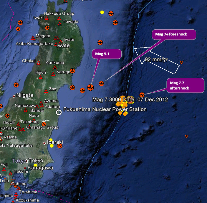
here is a map of the fore and aftershocks of the March 2011 mega quake mixed with the 7.4 and aftershocks from yesterday (just the Off East Coast Of Honshu. Japan ones)
9.0 marked by red star, yesterdays quakes have a 7 on the icons ( for 07/12/2012 )
mix map
early days yet, only 35 hours, but quite a few aftershocks.
I downloaded all of Japan, then eliminated the other islands and also Western Honshu, the result is what is left, all since the 7.4 quake.
interactive map
zoom out to see how it affected the whole of Honshu, although some of those little blue ones are probably background seismicity and would have happened anyway.
couple of screenshots (click image for larger view)


edit on 8-12-2012 by muzzy because: (no reason given)
just having a play around with the kml files
here is a map of the fore and aftershocks of the March 2011 mega quake mixed with the 7.4 and aftershocks from yesterday (just the Off East Coast Of Honshu. Japan ones)
9.0 marked by red star, yesterdays quakes have a 7 on the icons ( for 07/12/2012 )
mix map
edit on 8-12-2012 by muzzy because: (no reason given)
4.8 in Vanuatu, looks like it's the same line as the others.
Type: Earthquake
36 minutes ago
Magnitude: 4.8
DateTime: Saturday December 8 2012, 21:46:08 UTC
Region: Vanuatu
Depth: 134.9 km
Source: USGS Feed
Type: Earthquake
36 minutes ago
Magnitude: 4.8
DateTime: Saturday December 8 2012, 21:46:08 UTC
Region: Vanuatu
Depth: 134.9 km
Source: USGS Feed
forgot to add on post by muzzy
the 50% opacity grey icons without numbers are events in the "foreshocks" to the Mag 9.0, the rest are aftershocks coloured by size
that series of "foreshocks" was a lot closer to Honshu, and this latest quake and aftershock series is also at a different angle.
I don't believe this one is an aftershock of the 9.0, although they can go on for years, its way out on the Pacific Plate
BTW that file of the 9.0 is not the same as the one on the Japan 9.0 page which is just for 9 hours after the 9.0, I can't recall but I think its USGS data so you might as well ignore it due to inaccuracies
I just grabbed it from the list on Dropbox, I have 3 versions.
I might make a 4th version, with elasped time in the tags, if I can find the original csv file.
edit on 8-12-2012 by muzzy because: (no reason
given)
more on post by muzzy
4th and 5th versions of the Tohoku 9.0 quake.
I'm sure I did this before, but didn't have the data on file, so had to download it from NIED.
The 7.3 foreshock (and aftershocks of that, with elapsed time from the 7.3 AND "time before" (opposite of "elapsed" what ever the word is ) the 9.0 marked on each tag.
Also the 9.0 aftershocks for the first 72 hours (warning: file is 2.5MB) may take a wile to load the maps.
I may have been wrong about the 7.3 the other day not being an aftershock of the 9.0.
The 72 hr map shows 3 mag 6's and a 7.3 out there on the Pacific Plate in the same area so it is quite likely the recent quake IS an aftershock.
Thanks to the 3 people who went and had a look at the page yesterday !
Hopefully the page opens for ya, I had trouble the first try, had to refresh the page to get the 2nd map to come on.
edit on 9-12-2012 by muzzy because: (no reason given)
reply to post by muzzy
From previous post
And this one
Did I not say that Mr Muzzy?
Why, I even gave you a little map showing the positions. Tut tut
Seriously though, yes I do believe this is an aftershock of the Mag 9.
From previous post
I don't believe this one is an aftershock of the 9.0, although they can go on for years, its way out on the Pacific Plate
And this one
I may have been wrong about the 7.3 the other day not being an aftershock of the 9.0.
Did I not say that Mr Muzzy?
Why, I even gave you a little map showing the positions. Tut tut
Seriously though, yes I do believe this is an aftershock of the Mag 9.
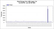
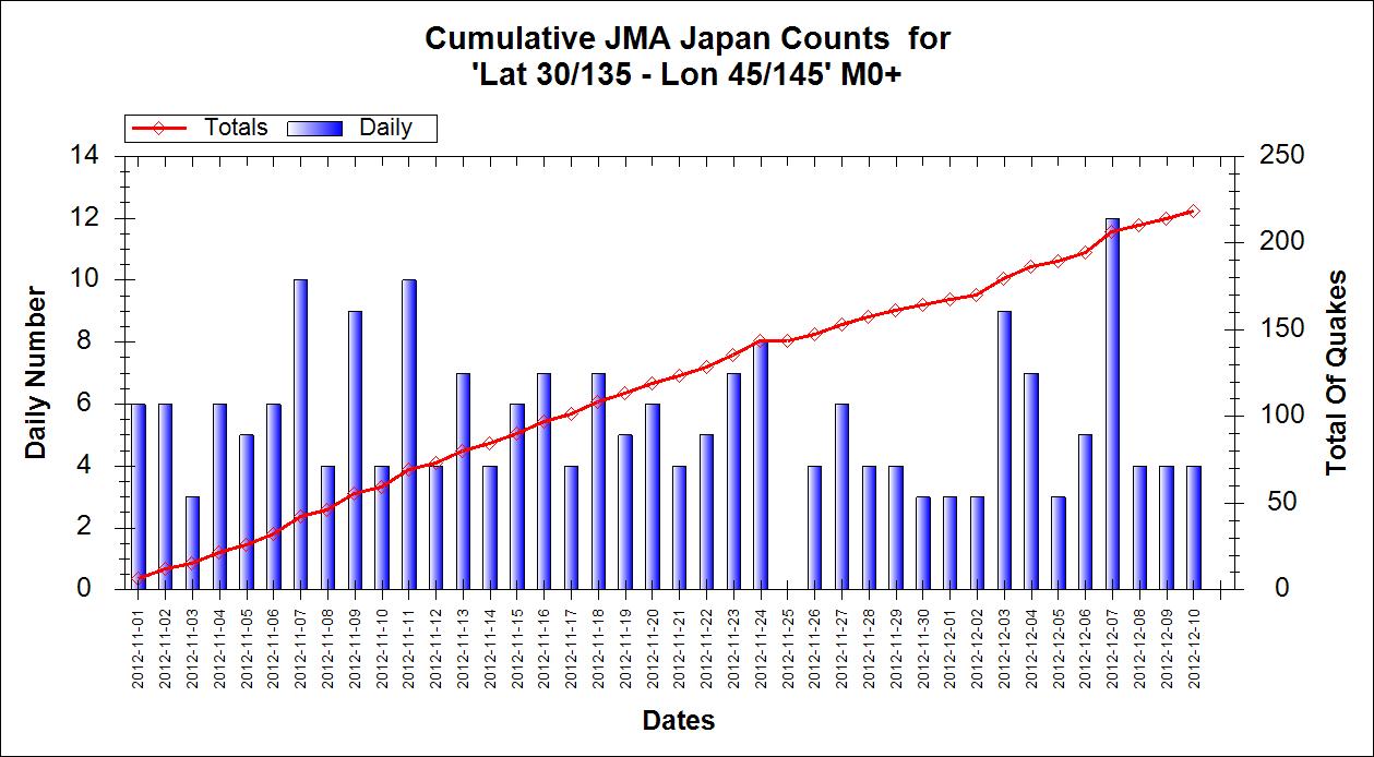
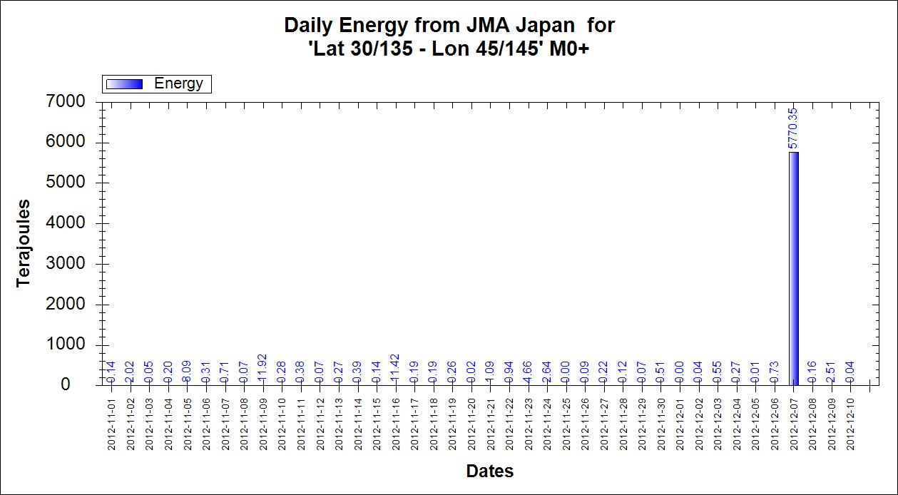
Is it just my feeling or did it somehow calm down arround Japan after the 7.3?
There are less quakes than normally on the JMA map which I watch several times a day
There are less quakes than normally on the JMA map which I watch several times a day
reply to post by aLLeKs
It is probably just your feeling as there were quiet periods before but here are some charts so you can decide for yourself.
Number of Quakes daily

Daily Energy - I have put bar labels on as the days other than the M7+ are swamped by that quake, but this allows you to see the values. All in Terajoules based on Mw so slightly out as JMA uses ML and I have not got the time to convert. The values will be proportionately the same.
It is probably just your feeling as there were quiet periods before but here are some charts so you can decide for yourself.
Number of Quakes daily
Daily Energy - I have put bar labels on as the days other than the M7+ are swamped by that quake, but this allows you to see the values. All in Terajoules based on Mw so slightly out as JMA uses ML and I have not got the time to convert. The values will be proportionately the same.
Earthquake Details
This event has been reviewed by a seismologist.
Magnitude
7.1
Date-Time
Monday, December 10, 2012 at 16:53:09 UTC
Tuesday, December 11, 2012 at 01:53:09 AM at epicenter
Location
6.522°S, 129.813°E
Depth
157.7 km (98.0 miles)
Region
BANDA SEA
Distances
236 km (147 miles) NW (313°) from Saumlaki, Tanimbar Islands, Indonesia
365 km (226 miles) SSE (150°) from Ambon, Moluccas, Indonesia
493 km (307 miles) W (260°) from Dobo, Aru Islands, Indonesia
520 km (323 miles) ENE (64°) from DILI, East Timor
Source
EMSC
Also one more GEOFON Banda Sea Dec 10 16:53 PM 7.0 164.0
Source
This event has been reviewed by a seismologist.
Magnitude
7.1
Date-Time
Monday, December 10, 2012 at 16:53:09 UTC
Tuesday, December 11, 2012 at 01:53:09 AM at epicenter
Location
6.522°S, 129.813°E
Depth
157.7 km (98.0 miles)
Region
BANDA SEA
Distances
236 km (147 miles) NW (313°) from Saumlaki, Tanimbar Islands, Indonesia
365 km (226 miles) SSE (150°) from Ambon, Moluccas, Indonesia
493 km (307 miles) W (260°) from Dobo, Aru Islands, Indonesia
520 km (323 miles) ENE (64°) from DILI, East Timor
Source
EMSC
Also one more GEOFON Banda Sea Dec 10 16:53 PM 7.0 164.0
EVALUATION A DESTRUCTIVE TSUNAMI WAS NOT GENERATED BASED ON EARTHQUAKE AND HISTORICAL TSUNAMI DATA. THIS EARTHQUAKE IS LOCATED TOO DEEP INSIDE THE EARTH TO GENERATE A TSUNAMI IN THE INDIAN OCEAN.
Source
edit on 10-12-2012 by lurksoften because: (no reason given)
edit on 10-12-2012 by lurksoften because: (no reason
given)
Just had a pop up saying there has been a major 7.2 quake in the Banda Sea Indonesia.
edit on 10-12-2012 by liverlad because: (no reason
given)
reply to post by liverlad
Yep.
Type: Earthquake
27 minutes ago
Magnitude: 7.1
DateTime: Monday December 10 2012, 16:53:09 UTC
Region: Banda Sea
Depth: 157.7 km
Source: USGS Feed
quakes.globalincidentmap.com...
Yep.
Type: Earthquake
27 minutes ago
Magnitude: 7.1
DateTime: Monday December 10 2012, 16:53:09 UTC
Region: Banda Sea
Depth: 157.7 km
Source: USGS Feed
quakes.globalincidentmap.com...
new topics
-
God's Righteousness is Greater than Our Wrath
Religion, Faith, And Theology: 2 hours ago -
Electrical tricks for saving money
Education and Media: 5 hours ago -
VP's Secret Service agent brawls with other agents at Andrews
Mainstream News: 6 hours ago -
Sunak spinning the sickness figures
Other Current Events: 7 hours ago -
Nearly 70% Of Americans Want Talks To End War In Ukraine
Political Issues: 7 hours ago -
Late Night with the Devil - a really good unusual modern horror film.
Movies: 9 hours ago -
Cats Used as Live Bait to Train Ferocious Pitbulls in Illegal NYC Dogfighting
Social Issues and Civil Unrest: 10 hours ago
top topics
-
VP's Secret Service agent brawls with other agents at Andrews
Mainstream News: 6 hours ago, 9 flags -
Florida man's trip overseas ends in shock over $143,000 T-Mobile phone bill
Social Issues and Civil Unrest: 17 hours ago, 8 flags -
Cats Used as Live Bait to Train Ferocious Pitbulls in Illegal NYC Dogfighting
Social Issues and Civil Unrest: 10 hours ago, 8 flags -
Electrical tricks for saving money
Education and Media: 5 hours ago, 4 flags -
Bobiverse
Fantasy & Science Fiction: 17 hours ago, 3 flags -
HORRIBLE !! Russian Soldier Drinking Own Urine To Survive In Battle
World War Three: 14 hours ago, 3 flags -
Nearly 70% Of Americans Want Talks To End War In Ukraine
Political Issues: 7 hours ago, 3 flags -
Sunak spinning the sickness figures
Other Current Events: 7 hours ago, 3 flags -
Late Night with the Devil - a really good unusual modern horror film.
Movies: 9 hours ago, 2 flags -
The Good News According to Jesus - Episode 1
Religion, Faith, And Theology: 12 hours ago, 1 flags
active topics
-
Cats Used as Live Bait to Train Ferocious Pitbulls in Illegal NYC Dogfighting
Social Issues and Civil Unrest • 20 • : Asher47 -
Nearly 70% Of Americans Want Talks To End War In Ukraine
Political Issues • 12 • : Asher47 -
VP's Secret Service agent brawls with other agents at Andrews
Mainstream News • 39 • : Asher47 -
Electrical tricks for saving money
Education and Media • 4 • : Lumenari -
New whistleblower Jason Sands speaks on Twitter Spaces last night.
Aliens and UFOs • 54 • : Ophiuchus1 -
DONALD J. TRUMP - 2024 Candidate for President - His Communications to Americans and the World.
2024 Elections • 514 • : WeMustCare -
The Acronym Game .. Pt.3
General Chit Chat • 7744 • : bally001 -
Truth Social goes public, be careful not to lose your money
Mainstream News • 128 • : Astyanax -
Sunak spinning the sickness figures
Other Current Events • 5 • : glen200376 -
SETI chief says US has no evidence for alien technology. 'And we never have'
Aliens and UFOs • 44 • : MikeDeGrasseTyson