It looks like you're using an Ad Blocker.
Please white-list or disable AboveTopSecret.com in your ad-blocking tool.
Thank you.
Some features of ATS will be disabled while you continue to use an ad-blocker.

Quake Watch 2012
page: 268share:
reply to post by PuterMan
Fascinating! You would of course have to check for mundane causes such as building new freeways and such but there are a few straight lines the do not belong there.
I watched a discovery channel show on tunneling through the Alps (I think it was the Alps) and it occurred to me that if you wanted a very big underground facility you only need to start one of these massive tunneling machines and you can tunnel for Kilometer after Kilometer (or Mile after Mile).
To keep it secret is a lot easier as there is only one entrance and if that was in an old open cut mine, well, it would not be difficult. Underground noises anyone. Perhaps I should create a dedicated thread.
Puterman, want to do some more digging say Continental US. (before they take the data down, ROFL)
P
edit on 21/11/2012 by pheonix358 because: (no reason given)
Puterman and other interested parties it is here. www.abovetopsecret.com... Saves messing up this thread.
P
P
21 November 2012, 1:45 pm NZDT (00:45:00 UTC) - Eruption at Tongariro/Te Maari Craters; Volcanic Alert Level is raised to Level 2; Aviation Colour
Code is changed to Red
posted the video over on ATS Volcano Watch 2012 this morning, but took me a while to find the earthquakes to go with it.
GNS (Geonet) scientists were saying on TV and in the newspaper that there was no warning, THIS IS NOT TRUE, there were 3 quakes (below mag 1) at Te Maari crater early that morning (the day before UTC), about an hour apart, classic volcanic earthquake timing
being >mag 1 they might be hard to see on the map depending on what type you view it in as >1 icons are very faint
Tongariro volcanic earthquakes at Te Maari crater the day before the eruption
if you can't see them click on 5th, 6th and 8th icon on the left column list and a popup tag will show each one
and twenty minutes before the eruption itself a mag 1.64ML, but 5.74km to the north of Te Maari Craters
NZ map of 21st UTC, day of the eruption
data from the Geonet SeisComP3 beta search query for UTC 20-21 * clicking this will open an Excel file with the data in csv format. I'm not sure what happens if you don't have Excel.
posted the video over on ATS Volcano Watch 2012 this morning, but took me a while to find the earthquakes to go with it.
GNS (Geonet) scientists were saying on TV and in the newspaper that there was no warning, THIS IS NOT TRUE, there were 3 quakes (below mag 1) at Te Maari crater early that morning (the day before UTC), about an hour apart, classic volcanic earthquake timing
ID, WHEN, LAT,LONG,MAG, DEPTH, WHERE
2012p876074, 20/11/2012 03:32:14, -39.131, 175.6486, 0.92ML, 5.3km, Tongariro Northern Circuit
2012p876182, 20/11/2012 04:29:47, -39.1232, 175.6496, 0.63ML, 5.2km, Tongariro Alpine Crossing
2012p876321, 20/11/2012 05:44:17, -39.1292, 175.6522, 0.59ML, 5.0km, Tongariro Alpine Crossing
being >mag 1 they might be hard to see on the map depending on what type you view it in as >1 icons are very faint
Tongariro volcanic earthquakes at Te Maari crater the day before the eruption
if you can't see them click on 5th, 6th and 8th icon on the left column list and a popup tag will show each one
and twenty minutes before the eruption itself a mag 1.64ML, but 5.74km to the north of Te Maari Craters
2012p878425, 21/11/2012 00:24:51, -39.0792, 175.6425, 1.64ML, 1km, Tongariro Alpine Crossing
NZ map of 21st UTC, day of the eruption
data from the Geonet SeisComP3 beta search query for UTC 20-21 * clicking this will open an Excel file with the data in csv format. I'm not sure what happens if you don't have Excel.
edit on 22-11-2012 by muzzy because: (no reason given)
Strange tiny one just through.
M 2.0 - Islay Argyll/Bute on Thu, 22/11/2012 19:46 GMT.
M 2.0 - Islay Argyll/Bute on Thu, 22/11/2012 19:46 GMT.
earthquake.usgs.gov/earthquakes/eventpage/usc000dx8s
j.r.c.b. - Shaking just felt all around south jersey...
www.abovetopsecret.com/forum/thread901886/pg1
edit on 23-11-2012 by wujotvowujotvowujotvo because: (no reason given)
Well, in less than an hour, the 6.1 in Tonga will drop off of the list.
Then there will be a week long, totally black list.
Cue the anticipatory background music!!!
Wait...for it...do, do, do, do.....do, do, do, do.........
WOQ
Then there will be a week long, totally black list.
Cue the anticipatory background music!!!
Wait...for it...do, do, do, do.....do, do, do, do.........
WOQ
3.0 7km NE of Sevierville, Tennessee 2012-11-24 06:03:13 35.922°N 83.507°W 5.0
And has this one been posted yet?
2.0 3km WNW of Belfast, Maine 2012-11-23 23:25:22 44.442°N 69.042°W 4.8
Oh, and the source, USGS earthquake.usgs.gov...
And has this one been posted yet?
2.0 3km WNW of Belfast, Maine 2012-11-23 23:25:22 44.442°N 69.042°W 4.8
Oh, and the source, USGS earthquake.usgs.gov...
edit on 11/24/2012 by Nyiah because: (no reason given)
Originally posted by Nyiah
3.0 7km NE of Sevierville, Tennessee 2012-11-24 06:03:13 35.922°N 83.507°W 5.0
And has this one been posted yet?
2.0 3km WNW of Belfast, Maine 2012-11-23 23:25:22 44.442°N 69.042°W 4.8
Oh, and the source, USGS earthquake.usgs.gov...edit on 11/24/2012 by Nyiah because: (no reason given)
Thank you for that info. I don't live too far from Sevierville, but I didn't feel anything here. My brother lives in that area. I'll have to call him today to see if he felt it.
Do you think there will be more to follow?
One in Missouri:
2.4 9km E of Malden, Missouri 2012-11-24 08:46:11 36.559°N 89.858°W 9.1
USGS earthquake.usgs.gov...
PuterMan, out of curiosity, do these Midwestern/Eastern states tend to get this much activity, as we've been seeing lately, or is there an uptick in activity going on? I'm curious if you might have a handy timeline graph for the Midwestern/Eastern US at your ready
NZ energy released level for month of Nov 2012 looking to be the lowest for 4 years at 958TTNT
see graphs at bottom of this page
could be something 5ish coming up before the end of the month?
deep quake off the East Coast of the North Island under the PPlate the other day, small, but unusually deep for there, Gisborne Knolls.
about 75km east of the 6.8 that did a bit of damage in Dec 2008
see graphs at bottom of this page
could be something 5ish coming up before the end of the month?
deep quake off the East Coast of the North Island under the PPlate the other day, small, but unusually deep for there, Gisborne Knolls.
about 75km east of the 6.8 that did a bit of damage in Dec 2008
Ref: 2012p883199
Status: automatic
Lat/Long: -38.7719 179.4475
When: 22/11/2012 18:47:27 UTC
Depth: 552.5 km
Mag: 3.06 ML
Location: Gisborne Knolls
Region: East Of North Island. N.Z.
Energy Released: 0.587 tonnes of TNT
Source:SeisComP3
I've been watching live Eq's map .....greece has been having small quakes every 15-20 minutes for quite a while now....is there volcanic activity
there also?
reply to post by ujustneverknow
Greece has about 45-50 quakes per day, mostly below Mag 3, say 1400-1600 a month so when you divide that back down that could be 4 per hour.
So your quake every 15-20 minutes is about right.
What magnitude are you looking at there?
I give it some coverage here. I gave up plotting every quake its too much work when you ain't gettin paid for it, so just do 3+ once every month for archival purposes now.
There are no active volcano's right now, but the Aegean has a long history of volcanic activity in the past(Thera in particular)
edit on
25-11-2012 by muzzy because: (no reason given)
ty Puterman !
I know it's an active area , the mags are around 2.2 .
I just noticed a cluster today that stuck out from the rest,lol.
I need to not watch that map so much!
I know it's an active area , the mags are around 2.2 .
I just noticed a cluster today that stuck out from the rest,lol.
I need to not watch that map so much!
Originally posted by ujustneverknow
ty Puterman !
I know it's an active area , the mags are around 2.2 .
I just noticed a cluster today that stuck out from the rest,lol.
I need to not watch that map so much!
'twas Muzzy the Map that responded to you not PM the Plot.
On another subject dear to our hearts, well the above mentioned anyway, here is the description of magnitudes from REV
A number that characterizes the relative size of an earthquake. Magnitude is based on measurement of the maximum motion recorded by a seismograph. Several scales have been defined, but the most commonly used are (1) local magnitude (ML), commonly referred to as "Richter magnitude," (2) surface-wave magnitude (Ms), (3) body-wave magnitude (Mb), and (4) moment magnitude (Mw). Scales 1-3 have limited range and applicability and do not satisfactorily measure the size of the largest earthquakes. The moment magnitude (Mw) scale, based on the concept of seismic moment, is uniformly applicable to all sizes of earthquakes but is more difficult to compute than the other types. All magnitude scales should yield approximately the same value for any given earthquake.
REV glossary
Emphasis by me. Shame they don't go the extra mile and publish all quakes in Mw.
Interestingly it says at the bottom of the page: Most definitions on this page provided by the USGS.
You may also like to note that the entry for the Mag 5.9 Mw off Chile a couple of days ago is Mag 6.1 in REV.
I have been aware of this site for a long time and I quite like it. I must get back to using ti but it is al time, time, time!
reply to post by ujustneverknow
Is it this series of earthquakes that caught your eye?
off Bozburun Aciklari, Mulga, Turkey
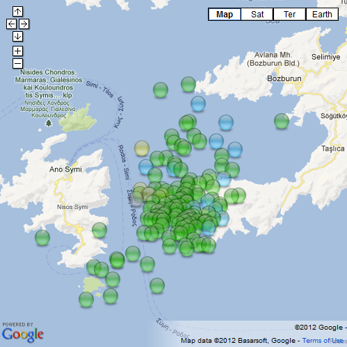
EMSC call this spot "Dodecanese Islands, Greece" and the Greeks describe the area as " N of Rhodos"
The National Observatory of Athens show a few on their Live last 24 hrs Map and EMSC have some (but I don't like EMSC much because they only have 2 decimal points in their lat/long and that makes it look like a grid (vague locations)) .
The best coverage of this series is provided by koeri - Bogazici University Kandilli Observatory and Earthquake Research Institute of Turkey.
interactive version of that map here
Seems to have started with a 4.4 ML at 9.04pm on the 24th UTC and just carried on from there, 139 events so far.
Hard to say if this is technically speaking a "Swarm", the 4.4 stands out as a higher magnitude event and it was the initial event, so these could just be aftershocks of that, although 139 aftershocks from a 4.4 seems a lot.
Perhaps there is a Mag 6 in the pipeline ( fault), although this area doesn't have a history of foreshock build up like the San Andreas does.
60 tonnes of TNT energy released in the 4.4L , next biggest a 4.3 (42TTNT) then two 4.0's (15TTNT), a few 3's but most of them 2's. All up at the time I downloaded the data 152 TTNT has been released, equal to a single 4.67ML quake.
Interesting though, pretty quiet elsewhere.
Is it this series of earthquakes that caught your eye?
off Bozburun Aciklari, Mulga, Turkey
EMSC call this spot "Dodecanese Islands, Greece" and the Greeks describe the area as " N of Rhodos"
The National Observatory of Athens show a few on their Live last 24 hrs Map and EMSC have some (but I don't like EMSC much because they only have 2 decimal points in their lat/long and that makes it look like a grid (vague locations)) .
The best coverage of this series is provided by koeri - Bogazici University Kandilli Observatory and Earthquake Research Institute of Turkey.
interactive version of that map here
Seems to have started with a 4.4 ML at 9.04pm on the 24th UTC and just carried on from there, 139 events so far.
Hard to say if this is technically speaking a "Swarm", the 4.4 stands out as a higher magnitude event and it was the initial event, so these could just be aftershocks of that, although 139 aftershocks from a 4.4 seems a lot.
Perhaps there is a Mag 6 in the pipeline ( fault), although this area doesn't have a history of foreshock build up like the San Andreas does.
60 tonnes of TNT energy released in the 4.4L , next biggest a 4.3 (42TTNT) then two 4.0's (15TTNT), a few 3's but most of them 2's. All up at the time I downloaded the data 152 TTNT has been released, equal to a single 4.67ML quake.
Interesting though, pretty quiet elsewhere.
edit on 25-11-2012 by muzzy because: (no reason given)
reply to post by PuterMan
yeah that would make it more clear ( less confusing)
Italy (INGV) seem to be the only ones who convert everything (down to mag 3) into Mw, (on their historical data)
yeah that would make it more clear ( less confusing)
Italy (INGV) seem to be the only ones who convert everything (down to mag 3) into Mw, (on their historical data)
5.5 earthquake, 296km SSE of Turpan, China. Nov 26 13:33 at epicenter depth 20km
2012-11-26 05:33:50 UTC
2012-11-26 13:33:50 UTC+08:00 at epicenter
2012-11-26 00:33:50 UTC-05:00 system time
Location
40.419°N 90.374°E depth=19.9km (12.3mi)
Nearby Cities
296km (184mi) SSE of Turpan, China
368km (229mi) SW of Hami, China
385km (239mi) ESE of Korla, China
440km (273mi) SSE of Urunchi, China
1340km (833mi) E of Bishkek, Kyrgyzstan
Originally posted by pheonix358
reply to post by FreebirdGirl
It is not the frac quakes you need to look for, they are all over the place right under the frac wells.
It is the man made quakes that could lead to straight line indications of sub surface building. That is, if it is actually ongoing. It could also account for strange sounds and similar mysteries that are occurring. Perhaps frac quakes are a cover for this activity.
P
Thanks Pheonix
Was wondering if someone could have a look at this post and
this post in the
Tremors felt 45 miles away from Bayou Corne Sinkhole! thread and answer the questions
regarding sesimometers and how accurate/sensitve the units in question are.
Additionally, if anyone has a way to go back and check and or display historical data for the reported rumblings and find any signatures it would add greatly to the understanding in the thread.
You guys rock!
Additionally, if anyone has a way to go back and check and or display historical data for the reported rumblings and find any signatures it would add greatly to the understanding in the thread.
You guys rock!
new topics
-
University of Texas Instantly Shuts Down Anti Israel Protests
Education and Media: 1 hours ago -
Any one suspicious of fever promotions events, major investor Goldman Sachs card only.
The Gray Area: 3 hours ago -
God's Righteousness is Greater than Our Wrath
Religion, Faith, And Theology: 8 hours ago -
Electrical tricks for saving money
Education and Media: 11 hours ago
top topics
-
VP's Secret Service agent brawls with other agents at Andrews
Mainstream News: 12 hours ago, 10 flags -
Cats Used as Live Bait to Train Ferocious Pitbulls in Illegal NYC Dogfighting
Social Issues and Civil Unrest: 16 hours ago, 8 flags -
Nearly 70% Of Americans Want Talks To End War In Ukraine
Political Issues: 13 hours ago, 4 flags -
Sunak spinning the sickness figures
Other Current Events: 13 hours ago, 4 flags -
Electrical tricks for saving money
Education and Media: 11 hours ago, 4 flags -
Late Night with the Devil - a really good unusual modern horror film.
Movies: 15 hours ago, 2 flags -
Any one suspicious of fever promotions events, major investor Goldman Sachs card only.
The Gray Area: 3 hours ago, 2 flags -
University of Texas Instantly Shuts Down Anti Israel Protests
Education and Media: 1 hours ago, 1 flags -
God's Righteousness is Greater than Our Wrath
Religion, Faith, And Theology: 8 hours ago, 0 flags
active topics
-
Nearly 70% Of Americans Want Talks To End War In Ukraine
Political Issues • 35 • : FlyersFan -
University of Texas Instantly Shuts Down Anti Israel Protests
Education and Media • 3 • : CriticalStinker -
Sunak spinning the sickness figures
Other Current Events • 13 • : Xtrozero -
Any one suspicious of fever promotions events, major investor Goldman Sachs card only.
The Gray Area • 7 • : seekshelter -
Hate makes for strange bedfellows
US Political Madness • 42 • : network dude -
-@TH3WH17ERABB17- -Q- ---TIME TO SHOW THE WORLD--- -Part- --44--
Dissecting Disinformation • 663 • : MetalThunder -
Russia Ukraine Update Thread - part 3
World War Three • 5731 • : Freeborn -
President BIDEN Vows to Make Americans Pay More Federal Taxes in 2025 - Political Suicide.
2024 Elections • 137 • : CriticalStinker -
I think this life means something.
Philosophy and Metaphysics • 59 • : seekshelter -
Late Night with the Devil - a really good unusual modern horror film.
Movies • 5 • : chiefsmom