It looks like you're using an Ad Blocker.
Please white-list or disable AboveTopSecret.com in your ad-blocking tool.
Thank you.
Some features of ATS will be disabled while you continue to use an ad-blocker.

Quake Watch 2012
page: 267share:
I'm surprised no one has submitted these to the thread yet, considering the locations.
1.6 7km SW of Lilbourn, Missouri 2012-11-19 07:29:02 36.544°N 89.669°W 4.7
2.6 12km SW of Cordova, Alabama 2012-11-19 10:20:10 33.690°N 87.293°W 1.0
2.3 3km ESE of Mansfield, Texas 2012-11-19 23:50:35 32.552°N 97.111°W 5.0
earthquake.usgs.gov...
I know they're not much to get excited about being such low magnitudes, but one if them is certainly worth noting, considering it's location.
reply to post by kdog1982
Hi KD, no I had not seen it. Very luminescent. Not being grumpy or anything but why did they not make the bottom of the axis Mag 5 which would have shown up that variance much better.
I may do one myself when I can get my spacing routine working again.
Hi KD, no I had not seen it. Very luminescent. Not being grumpy or anything but why did they not make the bottom of the axis Mag 5 which would have shown up that variance much better.
I may do one myself when I can get my spacing routine working again.
reply to post by Nyiah
I got excited about the Alabama earthquake. But it wasn't an earthquake. It was a mining blast.
The Missouri quake is a small, very regular one. (the regular-or "normal" earthquakes are now the exceptions)
And for the lone star quake. It was a frackquake. On google maps you find that the epicenter is right near a bunch of injection wells. And a Pier One Imports if you need some clothings.
I mean, they're not even trying hard to hide the mess. You got the wells right inside municipal boundries. But that's what you get when there is no democracies at the state level. Texas is a Republican dictatorship. And in Texas, the Republican Party is run by the oil boys. So, zoning laws, are mere paper formalities. These papers, are about as precious, and as strong as, toliet paper.
Oh, Oklahoma. I think there was one day where there wasn't an earthquake. Yes, on the 18th, there wasn't an earthquake.
I'm going to say Muzzy is right and some of the "6's" were only in the high "5's". But that being said, there still was a big clustering of 5.5+s and then a bit of a lull. So, even if we are around the normal averages, they don't come in steady drips, they come in waves.
Hmm. I'm wrong. I really thought Virginia would reply to Colorado. There's been another one near Trindad, but nothing in the east.
To add, I must admit that I'm not sure about the wells in that Texas frackquake. It's hard to distinguish between a production well and and injection well. There was a pond, so, I thought maybe they were drilling for gas. (do you know why there are no starlings in my backyard? the european sparrows chase them away) But, what if the pands are where they dump excess water that still needs to be swept under the carpet. Oh, I don't know. The fracking images on google are years old so there may be more wells in the area.
Also, I've revised my thoughts on the whole liquified natural gas theory. Yes, much of it still is valid. But my claculations are short because I forgot one very gigantic number. How could I forget that giant amount. Duh.
I'll expand on this in my crazy corner at some point soon. If you want to jump ahead all you have to do is read up on the oil production in the Dakotahs. To see their future you only have to look north to Alberta and the oilsands and soon many towns in the new oil boom will resemble Fort McMurray.
en.wikipedia.org...
sorry, reading. "Fort McMurray is a multicultural community, attracting people from all corners of Canada and the world. Albertans make up almost half the number of migrants to Fort McMurray, followed by 17% of people originating from the province of Newfoundland and Labrador.[citation needed] A report in 1986 noted that 13.8% of Fort McMurray's population was from Newfoundland."
[ask yourself, where did the newfie's first originate?
it seems not to be their first migration]
I got excited about the Alabama earthquake. But it wasn't an earthquake. It was a mining blast.
The Missouri quake is a small, very regular one. (the regular-or "normal" earthquakes are now the exceptions)
And for the lone star quake. It was a frackquake. On google maps you find that the epicenter is right near a bunch of injection wells. And a Pier One Imports if you need some clothings.
I mean, they're not even trying hard to hide the mess. You got the wells right inside municipal boundries. But that's what you get when there is no democracies at the state level. Texas is a Republican dictatorship. And in Texas, the Republican Party is run by the oil boys. So, zoning laws, are mere paper formalities. These papers, are about as precious, and as strong as, toliet paper.
Oh, Oklahoma. I think there was one day where there wasn't an earthquake. Yes, on the 18th, there wasn't an earthquake.
I'm going to say Muzzy is right and some of the "6's" were only in the high "5's". But that being said, there still was a big clustering of 5.5+s and then a bit of a lull. So, even if we are around the normal averages, they don't come in steady drips, they come in waves.
Hmm. I'm wrong. I really thought Virginia would reply to Colorado. There's been another one near Trindad, but nothing in the east.
To add, I must admit that I'm not sure about the wells in that Texas frackquake. It's hard to distinguish between a production well and and injection well. There was a pond, so, I thought maybe they were drilling for gas. (do you know why there are no starlings in my backyard? the european sparrows chase them away) But, what if the pands are where they dump excess water that still needs to be swept under the carpet. Oh, I don't know. The fracking images on google are years old so there may be more wells in the area.
Also, I've revised my thoughts on the whole liquified natural gas theory. Yes, much of it still is valid. But my claculations are short because I forgot one very gigantic number. How could I forget that giant amount. Duh.
I'll expand on this in my crazy corner at some point soon. If you want to jump ahead all you have to do is read up on the oil production in the Dakotahs. To see their future you only have to look north to Alberta and the oilsands and soon many towns in the new oil boom will resemble Fort McMurray.
en.wikipedia.org...
edit on 20-11-2012 by ericblair4891 because: (no reason given)
sorry, reading. "Fort McMurray is a multicultural community, attracting people from all corners of Canada and the world. Albertans make up almost half the number of migrants to Fort McMurray, followed by 17% of people originating from the province of Newfoundland and Labrador.[citation needed] A report in 1986 noted that 13.8% of Fort McMurray's population was from Newfoundland."
[ask yourself, where did the newfie's first originate?
it seems not to be their first migration]
edit on 20-11-2012 by ericblair4891 because: (no reason given)
edit on 20-11-2012 by ericblair4891 because: (no reason
given)
www.youtube.com...
Four. Four fuc frackin' frackquakes in one day. Only one showing up on the usgs and others. but, the state is rocking.
www.okgeosurvey1.gov...
Very soon now me thinks a big fault will crack and we'll get a 4+ it's been too low for too long due to glut. but for some reason, they're pumping or dumping big time in Okie. you can tell what areas are producing just by following the earthquakes.
big foot prints.
big foot
saskquatch
monster
earthquake.usgs.gov...
edit on 20-11-2012 by ericblair4891 because: (no reason given)
Hello,
I find myself at 4274 North Boulevard Street, (am i kidding- boulevard street- a redundant redunadancy) Edmond Oklahoma. 8km north of Edmond really.
I had to look around here and I think I found something big. It's a whole yard of pipe. At least I think it's pipe. I've been trying to figure it out. I'm sure they ain't rails. They ain't building anymore railroads and you don't need that much space cause rails are very uniform and can be made to order on short demand. It has to be a yard for pipe. It's massive.
Quakes and pipe seem to go in hand.
Why am I still looking?
The address is really , about, 4464North Boulevard Street, (why do i feel like i could get shot here?)
the name on the sign is fuzzy
All apologies. It's no shadowy conspiracy. They're listed. Turner Bros. Edmond Pipe yard. Man is it big. sorry again.
I find myself at 4274 North Boulevard Street, (am i kidding- boulevard street- a redundant redunadancy) Edmond Oklahoma. 8km north of Edmond really.
I had to look around here and I think I found something big. It's a whole yard of pipe. At least I think it's pipe. I've been trying to figure it out. I'm sure they ain't rails. They ain't building anymore railroads and you don't need that much space cause rails are very uniform and can be made to order on short demand. It has to be a yard for pipe. It's massive.
Quakes and pipe seem to go in hand.
Why am I still looking?
The address is really , about, 4464North Boulevard Street, (why do i feel like i could get shot here?)
the name on the sign is fuzzy
edit on 20-11-2012 by ericblair4891 because: (no reason given)
All apologies. It's no shadowy conspiracy. They're listed. Turner Bros. Edmond Pipe yard. Man is it big. sorry again.
edit on 20-11-2012 by ericblair4891 because: (no reason given)
reply to post by ericblair4891
So your trying to say that the USGS site isn't listing all the quakes near the fracking sites. Go figure, it's probably coming down from the top.
So your trying to say that the USGS site isn't listing all the quakes near the fracking sites. Go figure, it's probably coming down from the top.
reply to post by rickymouse
I think that you may find it is quite normal not to include man made events. They do not seem to list things such as man made explosions. You may find they simply do not, and never have listed man made events and frac quakes are man made so there is no desire to list them.
This approach is historical and directives from on high would have reinforced the current SOP rather than create a new one.
The question that someone with the right contacts could answer is do they simply eliminate the frac quakes or do they transfer them to an internal file called 'man made events.'
Would be nice to have access to that file. These are geologists, they may well provide that information to anyone that asks for it. Now after that information is published they will be told not to provide it again but then, even that would be useful to prove deceit from above.
P
Magnitude 3.6 - Illinois
Locati on in Google Maps
- Date-Time: Tuesday, November 20, 2012 @ 23:28:22 UTC
- Earthquake location: 38.446°N, 87.868°W,
- Earthquake depth: 5.0 km
- Distances:
10km (6mi) WNW of Mount Carmel, Illinois
39km (24mi) SW of Vincennes, Indiana
58km (36mi) NNW of Evansville, Indiana
65km (40mi) WSW of Washington, Indiana
208km (129mi) SW of Indianapolis, Indiana
- Event ID: usc000dvxy
Derived from Event Data Source: USGS
Powered by QVSData
reply to post by pheonix358
Catch 22 for them.
If frac quakes are man made they don't list but to not list is to admit they are man made and they are not so happy to do that.
and frac quakes are man made
Catch 22 for them.
If frac quakes are man made they don't list but to not list is to admit they are man made and they are not so happy to do that.
edit on 20/11/2012 by PuterMan because: put so so instead of not so. Duh!
reply to post by PuterMan
Is it that they remove them from the list and the data goes to data heaven or do they save them to another file. It would be worth the question. How good are your contacts?
P
Is it that they remove them from the list and the data goes to data heaven or do they save them to another file. It would be worth the question. How good are your contacts?
P
reply to post by pheonix358
Well explosions are recorded - by which I mean mine blasts - in the ANSS catalogue, but I have to say that I have never investigated what they have in there.
I decided to go and have a look.
Here are the entries for blasts for today
Source
Looked those up. Very odd the one apparently in a built up area.
ETA: There seems to be something wrong with these. The two San Francisco ones are 100 metres deep (tunnelling? - is there a project going on) but the New Brunswick one is 11.6 km deep. A blast that deep? Don't think so.
Looks as if the 'blast' entry is the same time as the 1.5 quake so I think that one can be discounted as an erroneous entry.
Well explosions are recorded - by which I mean mine blasts - in the ANSS catalogue, but I have to say that I have never investigated what they have in there.
I decided to go and have a look.
Here are the entries for blasts for today
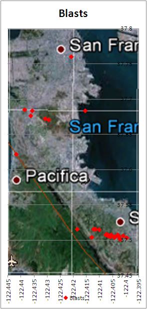
Date Time Lat Lon Depth Mag Magt Nst Gap Clo RMS SRC Event ID
----------------------------------------------------------------------------------------------
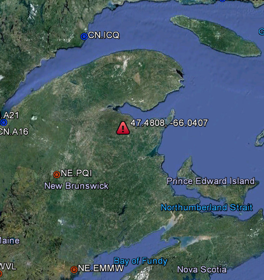
2012/11/20 15:33:28.01 47.4808 -66.0407 11.90 2.62 ML 6 205 10 0.14 NE
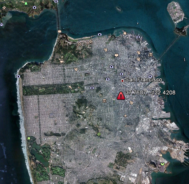
2012/11/20 18:42:22.73 37.7607 -122.4208 0.01 1.90 Unk 9 314 8 0.07 NC 71890226
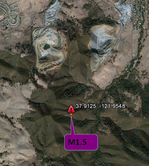
2012/11/20 18:50:24.17 37.9125 -121.9548 0.01 1.47 Md 9 81 4 0.02 NC 71890231
Source
Looked those up. Very odd the one apparently in a built up area.
ETA: There seems to be something wrong with these. The two San Francisco ones are 100 metres deep (tunnelling? - is there a project going on) but the New Brunswick one is 11.6 km deep. A blast that deep? Don't think so.
Looks as if the 'blast' entry is the same time as the 1.5 quake so I think that one can be discounted as an erroneous entry.
edit on 20/11/2012 by PuterMan because: (no reason given)
reply to post by PuterMan
Just to throw in some conspiracy stuff, oh come on, this is ATS after all.
Many threads exist on the NWO (whomever they are) building underground shelters. The easy way to do this is via tunneling machines. At some stages they have to blast their way through. It may be interesting to see if these man made events (low order quakes) have a pattern to them. Eg, do they follow straight lines. That depth is possible if someone is building something.
Getting back to reality, if they keep data on man made explosions do they have a separate file of frac quakes?
P
I just wanted to post this about the Illinois quake.. the 3.6
Per Earthquake Report. com
I also noticed Indiana, Illinois and even Co. felt rumblings last night into this morning as well... per the same site.. The "I felt it reports"
The two in Oklahoma I am assuming were too small to be felt.
Always keeping an eye out on the New Madrid. It was 100 years ago we had major EQ.
I am alert... tired, but alert.
Per Earthquake Report. com
EMSC Illinois Nov 20 23:28 PM 3.6 5.0 MAP I Felt It Unknown - Loud though. Crossville, IL - Very Quick and LOUD... Heard it coming. Slammed walls knocked a few pictures off. Only lasted a second or two. phillipstown - Heard it coming. Barely felt it.
I also noticed Indiana, Illinois and even Co. felt rumblings last night into this morning as well... per the same site.. The "I felt it reports"
The two in Oklahoma I am assuming were too small to be felt.
Always keeping an eye out on the New Madrid. It was 100 years ago we had major EQ.
I am alert... tired, but alert.
Originally posted by pheonix358
reply to post by PuterMan
Just to throw in some conspiracy stuff, oh come on, this is ATS after all.
Many threads exist on the NWO (whomever they are) building underground shelters. The easy way to do this is via tunneling machines. At some stages they have to blast their way through. It may be interesting to see if these man made events (low order quakes) have a pattern to them. Eg, do they follow straight lines. That depth is possible if someone is building something.
Getting back to reality, if they keep data on man made explosions do they have a separate file of frac quakes?
P
Interesting theory- do these fracs lead to Denver?
reply to post by FreebirdGirl
It is not the frac quakes you need to look for, they are all over the place right under the frac wells.
It is the man made quakes that could lead to straight line indications of sub surface building. That is, if it is actually ongoing. It could also account for strange sounds and similar mysteries that are occurring. Perhaps frac quakes are a cover for this activity.
P
reply to post by pheonix358
Your search parameters are:
catalog=ANSS
start_time=2000/01/01,00:00:00
end_time=2012/11/21,13:44:30
minimum_latitude=37.5
maximum_latitude=37.8
minimum_longitude=-122.5
maximum_longitude=-122.3
minimum_magnitude=0
maximum_magnitude=10
event_type=B
SF within the confines shown above
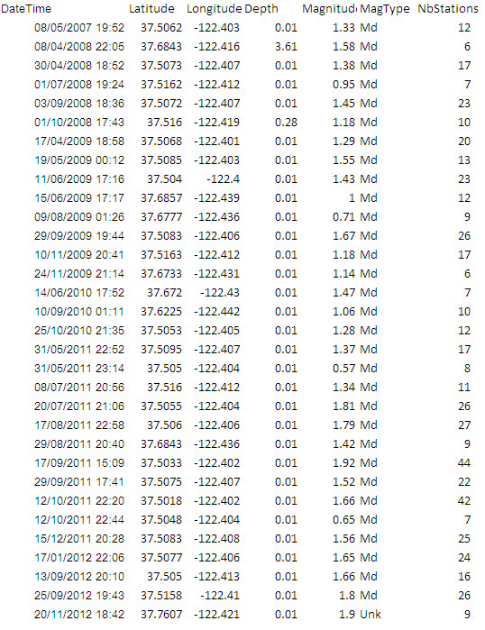
Do do do do......
But bear in mind these do not show the date sequence, but never the less very curious.
Your search parameters are:
catalog=ANSS
start_time=2000/01/01,00:00:00
end_time=2012/11/21,13:44:30
minimum_latitude=37.5
maximum_latitude=37.8
minimum_longitude=-122.5
maximum_longitude=-122.3
minimum_magnitude=0
maximum_magnitude=10
event_type=B
SF within the confines shown above
Do do do do......
But bear in mind these do not show the date sequence, but never the less very curious.
Chile just had another mag 6.1. It looks to be right at the shore.
USGS
Here is a map of the earthquakes in the area magnitude 6.0 and higher since just 01-01-2010.
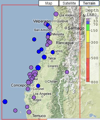
This link shows the table of eq's on the map above. It includes the mag 8.8 from February 2010.
Map and table data courtesy of IRIS earthquake browser
USGS
Here is a map of the earthquakes in the area magnitude 6.0 and higher since just 01-01-2010.
This link shows the table of eq's on the map above. It includes the mag 8.8 from February 2010.
Map and table data courtesy of IRIS earthquake browser
edit on 11/21/2012 by Olivine because: adding
reply to post by Olivine
I saw your post and thought, Mm my alert did not go off, or I missed it - possible as it was mealtime.
I see it is down to a 5.9 now. Tsk, don't want another 6 now do we.
Location in Google Maps
Derived from Event Data Source: USGS
Powered by QVSData
I saw your post and thought, Mm my alert did not go off, or I missed it - possible as it was mealtime.
I see it is down to a 5.9 now. Tsk, don't want another 6 now do we.
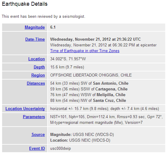
Magnitude 5.9 - Offshore Libertador O’Higgins. Chile
Location in Google Maps
- Date-Time: Wednesday, November 21, 2012 @ 21:36:22 UTC
- Earthquake location: 34.016°S, 72.017°W,
- Earthquake depth: 15.7 km
- Distances:
59km (36mi) SW of San Antonio, Chile
63km (39mi) SW of Cartagena, Chile
81km (50mi) WSW of Melipilla, Chile
90km (55mi) NW of Santa Cruz, Chile
141km (87mi) WSW of Santiago, Chile
- Event ID: usc000dwip
Derived from Event Data Source: USGS
Powered by QVSData
Originally posted by PuterMan
reply to post by Olivine
I see it is down to a 5.9 now. Tsk, don't want another 6 now do we.
I was thinkin the same thing Puterman
Funnything to add,.
there just so happened to be three M class flares since last night..
new topics
-
The functionality of boldening and italics is clunky and no post char limit warning?
ATS Freshman's Forum: 36 minutes ago -
Meadows, Giuliani Among 11 Indicted in Arizona in Latest 2020 Election Subversion Case
Mainstream News: 1 hours ago -
Massachusetts Drag Queen Leads Young Kids in Free Palestine Chant
Social Issues and Civil Unrest: 1 hours ago -
Weinstein's conviction overturned
Mainstream News: 2 hours ago -
Supreme Court Oral Arguments 4.25.2024 - Are PRESIDENTS IMMUNE From Later Being Prosecuted.
Above Politics: 4 hours ago -
Krystalnacht on today's most elite Universities?
Social Issues and Civil Unrest: 4 hours ago -
Chris Christie Wishes Death Upon Trump and Ramaswamy
Politicians & People: 4 hours ago -
University of Texas Instantly Shuts Down Anti Israel Protests
Education and Media: 7 hours ago -
Any one suspicious of fever promotions events, major investor Goldman Sachs card only.
The Gray Area: 9 hours ago
top topics
-
Krystalnacht on today's most elite Universities?
Social Issues and Civil Unrest: 4 hours ago, 8 flags -
Weinstein's conviction overturned
Mainstream News: 2 hours ago, 6 flags -
Supreme Court Oral Arguments 4.25.2024 - Are PRESIDENTS IMMUNE From Later Being Prosecuted.
Above Politics: 4 hours ago, 5 flags -
Electrical tricks for saving money
Education and Media: 16 hours ago, 5 flags -
University of Texas Instantly Shuts Down Anti Israel Protests
Education and Media: 7 hours ago, 5 flags -
Meadows, Giuliani Among 11 Indicted in Arizona in Latest 2020 Election Subversion Case
Mainstream News: 1 hours ago, 3 flags -
Chris Christie Wishes Death Upon Trump and Ramaswamy
Politicians & People: 4 hours ago, 2 flags -
Any one suspicious of fever promotions events, major investor Goldman Sachs card only.
The Gray Area: 9 hours ago, 2 flags -
Massachusetts Drag Queen Leads Young Kids in Free Palestine Chant
Social Issues and Civil Unrest: 1 hours ago, 2 flags -
God's Righteousness is Greater than Our Wrath
Religion, Faith, And Theology: 13 hours ago, 1 flags
active topics
-
Weinstein's conviction overturned
Mainstream News • 19 • : Vermilion -
Candidate TRUMP Now Has Crazy Judge JUAN MERCHAN After Him - The Stormy Daniels Hush-Money Case.
Political Conspiracies • 762 • : Oldcarpy2 -
Supreme Court Oral Arguments 4.25.2024 - Are PRESIDENTS IMMUNE From Later Being Prosecuted.
Above Politics • 52 • : CarlLaFong -
The functionality of boldening and italics is clunky and no post char limit warning?
ATS Freshman's Forum • 4 • : PorkChop96 -
University of Texas Instantly Shuts Down Anti Israel Protests
Education and Media • 158 • : Threadbarer -
-@TH3WH17ERABB17- -Q- ---TIME TO SHOW THE WORLD--- -Part- --44--
Dissecting Disinformation • 675 • : Thoughtful3 -
Meadows, Giuliani Among 11 Indicted in Arizona in Latest 2020 Election Subversion Case
Mainstream News • 3 • : network dude -
Any one suspicious of fever promotions events, major investor Goldman Sachs card only.
The Gray Area • 9 • : xuenchen -
President BIDEN Vows to Make Americans Pay More Federal Taxes in 2025 - Political Suicide.
2024 Elections • 145 • : ImagoDei -
Massachusetts Drag Queen Leads Young Kids in Free Palestine Chant
Social Issues and Civil Unrest • 7 • : nugget1