It looks like you're using an Ad Blocker.
Please white-list or disable AboveTopSecret.com in your ad-blocking tool.
Thank you.
Some features of ATS will be disabled while you continue to use an ad-blocker.

Quake Watch 2012
page: 264share:
reply to post by PuterMan
Yes, yes, yes!
I mean no, no, no!
Right date, different quakes.
The 8.2 & 8.6 near Sumatra!!!
Thanks for tying it together for me!
I must try to pry myself off of ATS earlier & get more sleep!
WOQ
Yes, yes, yes!
I mean no, no, no!
Right date, different quakes.
The 8.2 & 8.6 near Sumatra!!!
Thanks for tying it together for me!
I must try to pry myself off of ATS earlier & get more sleep!
WOQ
reply to post by pheonix358
Yes, of course I do and yes you could say my sense of humour is all over the place. I cannot be worrying about everything to the point of getting ulcers, and I sleep sound at night.
I might still be laughing at the end of the world, mainly because we are so full of our self importance as a species whereas in the great scheme of the Universe we are a bit of an irrelevance.
Cascadia WILL go, but I don't think Alaska is the key to that. I don't think that you will be hearing the screams from Australia, just yet, which I think was how you put it?
I may be wrong but I don't believe the M7.7 above the Cascadia fault, or the recent M6 in Alaska have affected the dynamics of the Cascadia zone. In a way I wish they had provided some stress relief, but I think that is not the case.
Cascadia has a few points to go before it reaches full Mag 9 potential, possibly until as long away as 2161, a date reached by extrapolating known events forward. Now that does NOT mean that there could not be a Mag 8.8 or anything under that as it would appear from my extrapolations that there is the potential there for that already, something I have already mentioned on this thread more than once.
You need to bear in mind with these things that there is a massive difference between an 8.8 and a 9. The M9 is twice a strong, but putting that in perspective we are talking about around 1,000,000 TERAJOULES of stress energy that would result in a Mag 9 instead of a Mag 8.8. Round about 239 Megtons of TNT or almost 5 times the largest thermonuclear weapon ever built if that helps visualise it better, and that is just the difference.
You suggested that the stress had reach the SW of the Pacific and would result in a strong event in May, but it did not. That is not to say you were wrong, just that it maybe is taking a little longer. I still expect there to be a stong quake around Vanuatu possibly before the end of the year. There was a 7.1 in Feb. but I think it is due another.
I can't make any prediction as to where the next Mag 9 will occur but it is my feeling that it will not be for possibly as much as 2 decades or more maybe even four - basically not until we move in towards the peak of the next 55/56 year solar cycle. I do hope I am right.
In the meantime I would request that, at least on the 21st December 2012 in the light of your recent findings, you please keep Shadow under control. I would hate to see a whole series of earthquakes on that day. Yes my sense of humour. Sorry!
The question is, do you still remember the conversation and why I have been watching for these. Cause if you did remember, you probably wouldn't be laughing, although you sense of humor is up and down all over the place!
Yes, of course I do and yes you could say my sense of humour is all over the place. I cannot be worrying about everything to the point of getting ulcers, and I sleep sound at night.
I might still be laughing at the end of the world, mainly because we are so full of our self importance as a species whereas in the great scheme of the Universe we are a bit of an irrelevance.
Cascadia WILL go, but I don't think Alaska is the key to that. I don't think that you will be hearing the screams from Australia, just yet, which I think was how you put it?
I may be wrong but I don't believe the M7.7 above the Cascadia fault, or the recent M6 in Alaska have affected the dynamics of the Cascadia zone. In a way I wish they had provided some stress relief, but I think that is not the case.
Cascadia has a few points to go before it reaches full Mag 9 potential, possibly until as long away as 2161, a date reached by extrapolating known events forward. Now that does NOT mean that there could not be a Mag 8.8 or anything under that as it would appear from my extrapolations that there is the potential there for that already, something I have already mentioned on this thread more than once.
You need to bear in mind with these things that there is a massive difference between an 8.8 and a 9. The M9 is twice a strong, but putting that in perspective we are talking about around 1,000,000 TERAJOULES of stress energy that would result in a Mag 9 instead of a Mag 8.8. Round about 239 Megtons of TNT or almost 5 times the largest thermonuclear weapon ever built if that helps visualise it better, and that is just the difference.
You suggested that the stress had reach the SW of the Pacific and would result in a strong event in May, but it did not. That is not to say you were wrong, just that it maybe is taking a little longer. I still expect there to be a stong quake around Vanuatu possibly before the end of the year. There was a 7.1 in Feb. but I think it is due another.
I can't make any prediction as to where the next Mag 9 will occur but it is my feeling that it will not be for possibly as much as 2 decades or more maybe even four - basically not until we move in towards the peak of the next 55/56 year solar cycle. I do hope I am right.
In the meantime I would request that, at least on the 21st December 2012 in the light of your recent findings, you please keep Shadow under control. I would hate to see a whole series of earthquakes on that day. Yes my sense of humour. Sorry!
edit on 13/11/2012 by PuterMan because: (no reason given)
2.6 37km NNE of Amboy, Washington 2012-11-13 19:52:00 46.194°N 122.184°W km.1.2
Mount St. Helens Area...yikes
Mount St. Helens Area...yikes
reply to post by PuterMan
Yes, I am very aware of the system used to measure quakes. On the Eastern seaboard it is not only a matter of how powerful the quake is but rather the combination of Power / Depth / Location. As they say in real estate, location, location, location.
I am more concerned with the loss of life that will occur. If the plate is springing back, then the quakes in the Gulf of Alaska is right where I thought they should be. Next should be a medium level swarm off BC Canada and then a series of powerful quakes moving South through the population centers.
This is not a prediction. Let's face it, we all no diddly squat about predicting these events. By stating what one person believes through study and observation allows us to say at a later stage either, hay, that person is onto something or else, no, didn't pan out.
The point is, either of those scenarios is very useful as we follow trends and tick off those that don't pan out.
I am staying away from human terms. It will happen. It will not be pleasant.
P
edit on 13/11/2012 by pheonix358 because: (no reason given)
4.7 in Bella Bella, BC (i guess this would be an aftershock from the Massett quake?)
earthquake.usgs.gov...
2nd most southward of these aftershocks since they started. Aftershocks, please stay away from cascadia!
earthquake.usgs.gov...
2nd most southward of these aftershocks since they started. Aftershocks, please stay away from cascadia!
edit on 13-11-2012 by
phoenixlights321 because: (no reason given)
edit on 13-11-2012 by phoenixlights321 because: (no reason given)
7hr 15min ago ago we almost had agreement at last on magnitude for an earthquake
no agreement on depth or location though
one objection
and I tend to agree with ldeo, just look at the size of that baby on NZSO, when I first seen it I thought it was another 6
compare to this 6 from Tonga on 26-12-2011
and this 5.6 from S of Tonga on 25-04-2012
no agreement on depth or location though
net, mag, timeUTC, lat, long , depth, where
usgs - 5.4 mb, 2012/11/13 23:23:49, -21.042, -175.934, 27.1, TONGA
gfz- 5.4mb, 2012-11-13 23:23:48, -20.93, -175.78, 10, Tonga Islands
emsc - 5.4mb, 2012-11-13 23:23:46.0, -21.06 , 175.90, 10, TONGA
ras- 5.4mb, 2012-11-13 23:23:48.8, -21.36, -175.78, 33, Tonga Islands
one objection
ldeo- 5.6, Mw? 2012 11 13 23 23 52.0, -20.75, -175.75, 33.0, TONGA ISLANDS
and I tend to agree with ldeo, just look at the size of that baby on NZSO, when I first seen it I thought it was another 6
compare to this 6 from Tonga on 26-12-2011
and this 5.6 from S of Tonga on 25-04-2012
reply to post by muzzy
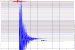
That one appears to be about 272 pixels peak to trough, but the top may be cut off. The depth will have decreased the trace.
The South of Tonga quake was actually the 24th
Peak to trough that one is 272 pixels but is closer to the surface.
The latest one is 221 pixels so considerably smaller, which makes 5.4 seem right or thereabouts. In addition 5.4 is ~5.74 Mw
Just saying!
Oh and don't forget that LDEO is based on surface waves whereas the others (mb) will be on the P wave.
Prov,Date/Time UTC,Latitude,Longitude,Magnitude,Depth(Km),Location
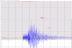
usgs,2011-12-26 04:48:08, -16.154, -173.798, 6.0, 78.6, Tonga
That one appears to be about 272 pixels peak to trough, but the top may be cut off. The depth will have decreased the trace.
The South of Tonga quake was actually the 24th
Prov,Date/Time UTC,Latitude,Longitude,Magnitude,Depth(Km),Location
usgs,2012-04-24 15:15:37, -24.207, -175.980, 5.6, 8.7, South Of Tonga
Peak to trough that one is 272 pixels but is closer to the surface.
The latest one is 221 pixels so considerably smaller, which makes 5.4 seem right or thereabouts. In addition 5.4 is ~5.74 Mw
Just saying!
Oh and don't forget that LDEO is based on surface waves whereas the others (mb) will be on the P wave.
I was going to wait and write and dump a bunch of links. But can't get brain around it and so I haven't. I had to pipe up when the whole of the
Americas were speaking. Now, I want to note the tinyest and briefest of respite ever. Almost imperceptively so. We're hanging on a hanging moon in a
cradle of a phony twilight's eclipse. Rock abye baby. In the tree tops.
If Cascadia pops at any moment I wouldn't be surprised at all. The siemic waves travelling up and down the spine are passing each other like cars on a giant north/south highway. I like the neuron idea better. But the traffic idea applies as well. How could Cascadia not be squeeze and nuzzled? Push from Japan. Knocked on the head and kicked in the bum.
Adding to say, that I cannot forget Mexico had a good jolt not too long ago.
South America is as south america does. It's activity is bascially normal and even if they got a 7M it would still be in normal range. But me no think so. South America has already adjusted back with the 8.8M. It's North America's turn. The quiet areas of North Amercia is active. Long stretches go by with nothing on the map between Alasaka and Washington State, and British Columbia. Then that gulf in Alaska. Central America. This is a list that is going away. Not a list that is trending toward a quiet restfull state. Cascdia has had a few modest bumps but nothing very energetic. These plate all nestled around Senior Juan or whomever, are - must be putting massive stresses at every end. And where's that energy being transferred. Under North America.
And this won't wait decades to spring. Less than a year.
edit on 14-11-2012 by ericblair4891 because: (no reason given)
6.2 Chile. No details yet
www.emsc-csem.org...
GFZ Potsdam give the same magnitude.
Location in Google Maps
Derived from Event Data Source: USGS
Powered by QVSData
There seems to be some confusion. EMSC sayoff shore near coast (they changed it to on land), USGS shows it on land.
2012-11-14 19:02:03, -29.110, -71.270, 6.2, 30.0, Nr. Coast Of Central Chile [EMSC Map]
EMSC are now in agreement with USGS @6.1. How sweet!
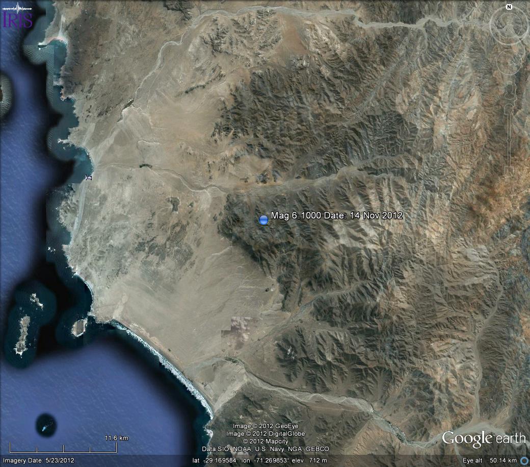
It looks relatively uninhabited and barren except for Caleta Carrizalillo (Middle left - the bed sign)

PAGER GREEN. 20k population MMI V and 632k MMI IV
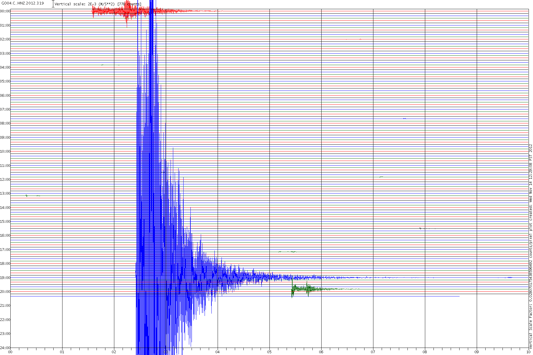
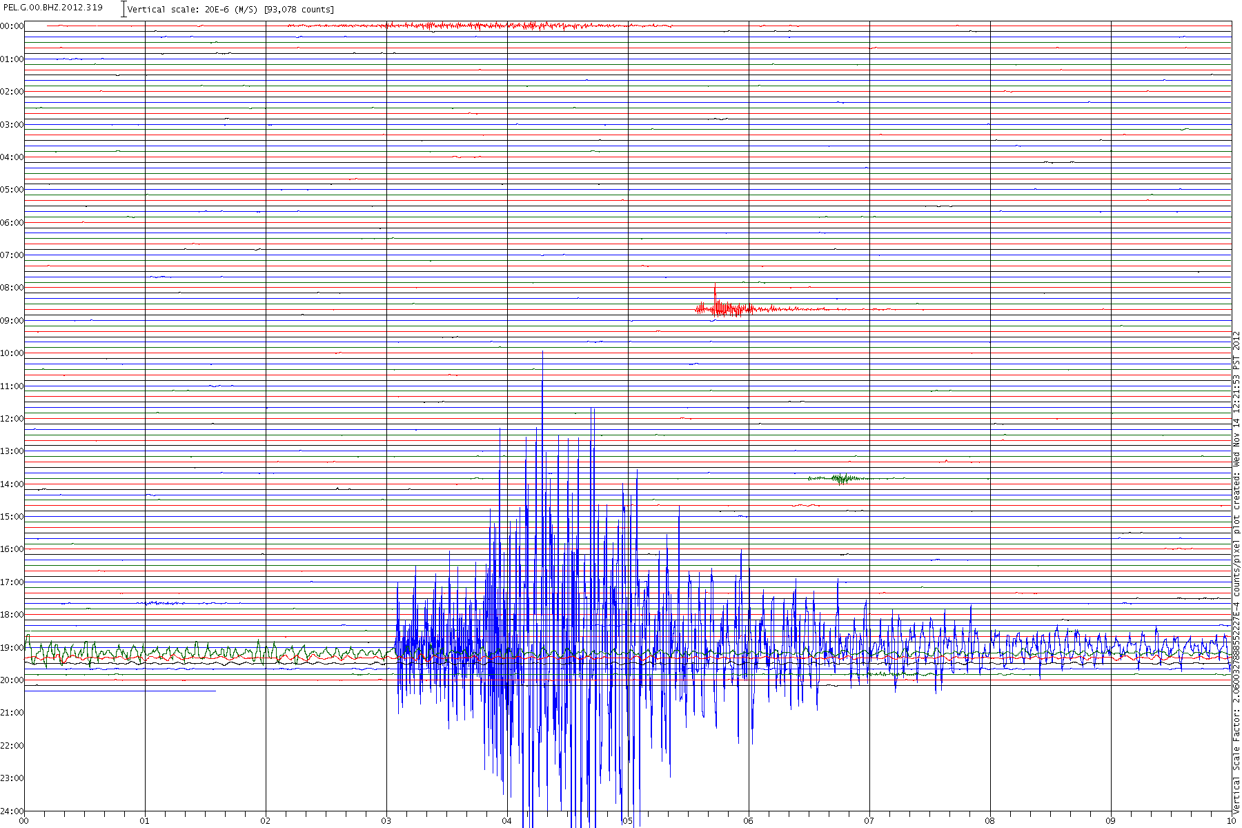
Seismogram: PEL.G.00.BHZ.2012.319
Here are some big ones for you
This one got bent out of shape! It was almost on top of the quake

Same as the linked one above
www.emsc-csem.org...
Magnitude M 6.2
Region OFFSHORE ATACAMA, CHILE
Date time 2012-11-14 19:01:58.0 UTC
Location 29.08 S ; 71.92 W
Depth 2 km
Distances 502 km NW Santiago (pop 4,837,295 ; local time 16:01:58.0 2012-11-14)
126 km SW Vallenar (pop 44,895 ; local time 16:01:58.0 2012-11-14)
112 km NW La serena (pop 154,521 ; local time 16:01:58.0 2012-11-14)
68 km W Andacollo (pop 9,872 ; local time 16:01:58.0 2012-11-14)
GFZ Potsdam give the same magnitude.
Magnitude 6.1 - Coquimbo. Chile
Location in Google Maps
- Date-Time: Wednesday, November 14, 2012 @ 19:02:05 UTC
- Earthquake location: 29.157°S, 71.272°W,
- Earthquake depth: 61.8 km
- Distances:
82km (50mi) SW of Vallenar, Chile
83km (51mi) N of La Serena, Chile
88km (54mi) N of Coquimbo, Chile
111km (68mi) NNW of Vicuna, Chile
480km (298mi) N of Santiago, Chile
- Event ID: usc000dski
Derived from Event Data Source: USGS
Powered by QVSData
There seems to be some confusion. EMSC say
2012-11-14 19:02:03, -29.110, -71.270, 6.2, 30.0, Nr. Coast Of Central Chile [EMSC Map]
EMSC are now in agreement with USGS @6.1. How sweet!
It looks relatively uninhabited and barren except for Caleta Carrizalillo (Middle left - the bed sign)
PAGER GREEN. 20k population MMI V and 632k MMI IV
Seismogram: PEL.G.00.BHZ.2012.319
Here are some big ones for you
This one got bent out of shape! It was almost on top of the quake
Same as the linked one above
edit on 14/11/2012 by PuterMan because: (no reason given)
There has been a swarm off the east coast of New Zealand overnight - in a subduction fault zone... where my family are from and a lot still live....
This is following hot on the heels of this press release from NIWA about the hundreds of new faults they've found offshore of our coast lines :
Niwa press release
related newspaper article
A ''swarm'' of earthquakes rocked the East Cape last night, including one felt as far away as Wellington and Taranaki.
Between 8.15pm yesterday and 6.55am today, 15 quakes were recorded around the East Cape, many east of Tolaga Bay, Geonet duty seismologist Caroline Little said.
The largest, a 4.5 magnitude shake at 5.21am, east of Tolaga Bay, was felt in Lower Hutt and Taranaki, she said.
Among the 15 quakes was a light intensity 3.3 magnitude quake at 10.24pm last night, followed by a moderate intensity 3.6 quake at 4.40am today, both east of Tolaga Bay.
The cluster of quakes in the same subduction zone - especially those near Tolaga Bay - were described as a ''swarm'' of earthquakes.
It was impossible to say if more were coming, Little said.
There was no risk of tsunami as a result of the quakes.
This is following hot on the heels of this press release from NIWA about the hundreds of new faults they've found offshore of our coast lines :
Niwa press release
related newspaper article
reply to post by Evltre
Where is Muzzy the Map when he is needed?
Looks like she is cracking up Jim!
Where is Muzzy the Map when he is needed?
Looks like she is cracking up Jim!
On the subject of earthquakes, I have to ask you, the experts: have you ever heard of "earthquake clouds" and, if so, have you ever seen any
first-hand?
I ask because while walking home from dropping my son off at school today, I saw the most unbelievable clouds. They were diamonds almost, with cross hatching in them, with the squares/diamonds all turned next to each other, like a fabric or even a tapestry. I was on the phone with my husband at the time and actually hung up with him so I could take a picture. Almost one hour later, they were still there, though in a different spot, just like a regular cloud. They weren't contrails and didn't fade or puff apart like they do, either. They were so strange looking, I did a search and found a site that has the exact clouds I saw:
www.terraresearch.net...
That is how I came up with the idea that I might be seeing earthquake clouds, since this is what they were classified as on that site. I have pictures but need to find my memory card to transfer the pics from my phone to my laptop, since I don't have bluetooth, but the site's pics show almost exactly what I took pictures of. I will upload them later, maybe to a separate thread, but wanted to ask opinions here first. So.... do you believe that earthquake clouds exist and, if so, what do they signify? Does this mean an earthquake is imminent in my area? I'm in CO, by the way.
Thanks!
ETA: I found this site, too, so turns out that this has been a theory for a very, very long time. Ancient chinese drew and described the cloud patterns that heralded quakes, usually within a day:
(Scroll down to page 5 on the site)
www.docstoc.com...
edit on 14-11-2012 by mountaingirl1111 because: (no reason given)
reply to post by mountaingirl1111
Upload those suckers.....and lets have a look!!
I have witnessed every one of those cloud anomalies in Memphis Tn. in the last 1.5 years........
And we have not shaken yet. However, we are all.....I am sure.....chompin' at the bit to see these goodies.
Upload those suckers.....and lets have a look!!
I have witnessed every one of those cloud anomalies in Memphis Tn. in the last 1.5 years........
And we have not shaken yet. However, we are all.....I am sure.....chompin' at the bit to see these goodies.
reply to post by mountaingirl1111
Sounds just like the vision disturbance I get with a migraine!
Yes I have heard of earthquake clouds. Do I believe in them? I don't think so. I see those sort of clouds and many others around here and we don't have earthquakes except the 4 off the coast a while ago and one a couple of years ago in Clare - and some tiddlers in the North on the extension of the Great Glen fault.
ETA (Scroll down to page 5 on the site) Wasn't able to do that and I am not going to log in to Facebook just to download. I HATE sites that demand that.
I ask because while walking home from dropping my son off at school today, I saw the most unbelievable clouds. They were diamonds almost, with cross hatching in them, with the squares/diamonds all turned next to each other, like a fabric or even a tapestry.
Sounds just like the vision disturbance I get with a migraine!
Yes I have heard of earthquake clouds. Do I believe in them? I don't think so. I see those sort of clouds and many others around here and we don't have earthquakes except the 4 off the coast a while ago and one a couple of years ago in Clare - and some tiddlers in the North on the extension of the Great Glen fault.
ETA (Scroll down to page 5 on the site) Wasn't able to do that and I am not going to log in to Facebook just to download. I HATE sites that demand that.
edit on 14/11/2012 by PuterMan because: (no reason given)
At the moment, I feel as if we're due for something big and or really strange. Or, I need to calm the freak down probably the latter.
The British Columbia government has woke up and smelled the coffee. I'll say nothing. Because it's not nearly enough.
The West Coast should be acting as if it can happen tomorrow.
news.nationalpost.com...
The British Columbia government has woke up and smelled the coffee. I'll say nothing. Because it's not nearly enough.
The West Coast should be acting as if it can happen tomorrow.
news.nationalpost.com...
reply to post by ericblair4891
I agree with you but i am just not sure its going to happen on west coast when and if the big one hits.
I agree with you but i am just not sure its going to happen on west coast when and if the big one hits.
Chile has 597 seismic detectors sitting in warehouses
Published November 12, 2012 / EFE
latino.foxnews.com/latino/politics/2012/11/12/chile-has-57-seismic-detectors-sitting-in-warehouses/
Published November 12, 2012 / EFE
latino.foxnews.com/latino/politics/2012/11/12/chile-has-57-seismic-detectors-sitting-in-warehouses/
The Chilean government has allowed 597 devices for detecting seismic events to sit in warehouses for the past 2 1/2 years, opposition lawmakers said Monday.
Chile, with 16.6 million people, is the world's most seismically active country, but lacks an adequate detection network.
Christian Democratic legislators Matias Walker and Ricardo Rincon said that they asked the Controller General's Office for a statement about the warehousing of 597 seismic detectors acquired toward the end of the 2006-2010 administration of President Michelle Bachelet.
Walker told reporters that the equipment can detect the location of earthquake epicenters and, thus, had it been installed, could have been able to provide warning about potential tsunamis along Chile's long coastline.
He added that the funds to purchase the 597 detectors were approved in the 2008 budget, and that amount was increased in subsequent years to $18 million, in total, so that the equipment could be installed throughout Chile.
He said that the system would have been allocated to the Seismological Service of the University of Chile although the Onemi emergency management agency had asked the government to be able to operate them, "but currently they are sitting in a warehouse."
Rincon said that the Controller General's Office should investigate the acquisition of the machines, given that their installation has been delayed by at least four years, which suggests that whenever they are actually put into operation they will already be obsolete.
The last big earthquake to hit Chile was a magnitude-8.8 monster that struck on Feb. 27, 2010.
The quake - and a subsequent tsunami - killed more than 500 people, left 800,000 with property damage and resulted in economic losses of $30 billion. EFE
reply to post by Evltre
Indeed, I counted 16 in 24 hours
map here
nothing to be concerned about though, as we say here on ATS its "normal", and I'm not joking either, take a look at my NZ Mag 3+ page and scroll back through the months, this "swarm" has been going on since Sept, and is probably related to the swarm that ran from June to August just out NE of there on the Pacific Plate.
I have mentioned this swarm a couple of times over that period here on ATS Quake Watch.
These happen quite regularly, in past years "offshore Matata" in the Bay of Plenty was the name that was cropping up every day, but that one had thousands in it and went on for months and months.
These off the East Coast NI, Tolaga Bay ones seem to be more spread out time wise.
If those 16 were Mag 4's or 5's then I'd be a wee bit concerned, but even then not overly so, take a look at this "swarm" off Auckland in the Summer (Dec/Jan) of 1984/85 , it was after a 6.3 Edgecumbe quake in March of that year ( not the bad one though, that was in 1987).
That NIWA press release is a bit of a overblown publicity dud .
That info has been available since 2010 and if you look on Canterbury Quake Live he has had them marked on the map since about March 2011.
and I've had some of the the Cook Strait ones marked on a map on my NZ blog since 2009
cook strait faults
Let me know when they issue a KMZ file of them all , that I could use on my maps.
Mag 2's are interesting if there are enough of them, take a look at the NZ Last 30 days Map centred on the same Tolaga Bay spot, and that was before I add todays 16, which I will do in the next hour or so.
In fact if you want to follow that area I started breaking NZ into regions, its a back-burner project right now, but I may get around to doing the rest of Sept and then Oct this weekend.
Right now the two Tolaga Bay/Gisborne relevant maps show nothing much at all for JulyAug, but that will all change for Sept/ Oct, if you click on the 1603 East Cape Ridge Off NI N.Z tab you will see swarm there moving SW in Sept towards offshore Tolaga Bay.
Indeed, I counted 16 in 24 hours
map here
nothing to be concerned about though, as we say here on ATS its "normal", and I'm not joking either, take a look at my NZ Mag 3+ page and scroll back through the months, this "swarm" has been going on since Sept, and is probably related to the swarm that ran from June to August just out NE of there on the Pacific Plate.
I have mentioned this swarm a couple of times over that period here on ATS Quake Watch.
These happen quite regularly, in past years "offshore Matata" in the Bay of Plenty was the name that was cropping up every day, but that one had thousands in it and went on for months and months.
These off the East Coast NI, Tolaga Bay ones seem to be more spread out time wise.
If those 16 were Mag 4's or 5's then I'd be a wee bit concerned, but even then not overly so, take a look at this "swarm" off Auckland in the Summer (Dec/Jan) of 1984/85 , it was after a 6.3 Edgecumbe quake in March of that year ( not the bad one though, that was in 1987).
That NIWA press release is a bit of a overblown publicity dud .
That info has been available since 2010 and if you look on Canterbury Quake Live he has had them marked on the map since about March 2011.
and I've had some of the the Cook Strait ones marked on a map on my NZ blog since 2009
cook strait faults
Let me know when they issue a KMZ file of them all , that I could use on my maps.
edit on 14-11-2012 by muzzy because: (no reason given)
Mag 2's are interesting if there are enough of them, take a look at the NZ Last 30 days Map centred on the same Tolaga Bay spot, and that was before I add todays 16, which I will do in the next hour or so.
edit on 14-11-2012 by muzzy because: (no reason given)
In fact if you want to follow that area I started breaking NZ into regions, its a back-burner project right now, but I may get around to doing the rest of Sept and then Oct this weekend.
Right now the two Tolaga Bay/Gisborne relevant maps show nothing much at all for JulyAug, but that will all change for Sept/ Oct, if you click on the 1603 East Cape Ridge Off NI N.Z tab you will see swarm there moving SW in Sept towards offshore Tolaga Bay.
edit on 15-11-2012 by muzzy because: (no reason given)
5.7 earthquake, 168km SE of Lorengau, Papua New Guinea. Nov 15 18:21 at epicenter (depth 9.9km)
2012-11-15 08:21:49 UTC
2012-11-15 18:21:49 UTC+10:00 at epicenter
2012-11-15 03:21:49 UTC-05:00 system time
Location
3.250°S 148.176°E depth=9.9km (6.2mi)
Nearby Cities
168km (104mi) SE of Lorengau, Papua New Guinea
300km (186mi) WSW of Kavieng, Papua New Guinea
335km (208mi) NW of Kimbe, Papua New Guinea
342km (213mi) NE of Madang, Papua New Guinea
693km (431mi) N of Port Moresby, Papua New Guinea
new topics
-
2024 Pigeon Forge Rod Run - On the Strip (Video made for you)
Automotive Discussion: 28 minutes ago -
Gaza Terrorists Attack US Humanitarian Pier During Construction
Middle East Issues: 54 minutes ago -
The functionality of boldening and italics is clunky and no post char limit warning?
ATS Freshman's Forum: 2 hours ago -
Meadows, Giuliani Among 11 Indicted in Arizona in Latest 2020 Election Subversion Case
Mainstream News: 2 hours ago -
Massachusetts Drag Queen Leads Young Kids in Free Palestine Chant
Social Issues and Civil Unrest: 2 hours ago -
Weinstein's conviction overturned
Mainstream News: 4 hours ago -
Supreme Court Oral Arguments 4.25.2024 - Are PRESIDENTS IMMUNE From Later Being Prosecuted.
Above Politics: 5 hours ago -
Krystalnacht on today's most elite Universities?
Social Issues and Civil Unrest: 5 hours ago -
Chris Christie Wishes Death Upon Trump and Ramaswamy
Politicians & People: 6 hours ago -
University of Texas Instantly Shuts Down Anti Israel Protests
Education and Media: 8 hours ago
top topics
-
Krystalnacht on today's most elite Universities?
Social Issues and Civil Unrest: 5 hours ago, 8 flags -
Weinstein's conviction overturned
Mainstream News: 4 hours ago, 6 flags -
University of Texas Instantly Shuts Down Anti Israel Protests
Education and Media: 8 hours ago, 5 flags -
Supreme Court Oral Arguments 4.25.2024 - Are PRESIDENTS IMMUNE From Later Being Prosecuted.
Above Politics: 5 hours ago, 5 flags -
Meadows, Giuliani Among 11 Indicted in Arizona in Latest 2020 Election Subversion Case
Mainstream News: 2 hours ago, 4 flags -
Massachusetts Drag Queen Leads Young Kids in Free Palestine Chant
Social Issues and Civil Unrest: 2 hours ago, 3 flags -
Any one suspicious of fever promotions events, major investor Goldman Sachs card only.
The Gray Area: 10 hours ago, 2 flags -
Chris Christie Wishes Death Upon Trump and Ramaswamy
Politicians & People: 6 hours ago, 2 flags -
Gaza Terrorists Attack US Humanitarian Pier During Construction
Middle East Issues: 54 minutes ago, 2 flags -
God's Righteousness is Greater than Our Wrath
Religion, Faith, And Theology: 15 hours ago, 1 flags
active topics
-
2024 Pigeon Forge Rod Run - On the Strip (Video made for you)
Automotive Discussion • 3 • : TheInvisibleRedneck -
Breaking Baltimore, ship brings down bridge, mass casualties
Other Current Events • 488 • : xuenchen -
Krystalnacht on today's most elite Universities?
Social Issues and Civil Unrest • 3 • : StudioNada -
Candidate TRUMP Now Has Crazy Judge JUAN MERCHAN After Him - The Stormy Daniels Hush-Money Case.
Political Conspiracies • 772 • : matafuchs -
University of Texas Instantly Shuts Down Anti Israel Protests
Education and Media • 178 • : theatreboy -
Gaza Terrorists Attack US Humanitarian Pier During Construction
Middle East Issues • 10 • : CarlLaFong -
The functionality of boldening and italics is clunky and no post char limit warning?
ATS Freshman's Forum • 8 • : grey580 -
Fossils in Greece Suggest Human Ancestors Evolved in Europe, Not Africa
Origins and Creationism • 84 • : whereislogic -
Ditching physical money
History • 21 • : SprocketUK -
Meadows, Giuliani Among 11 Indicted in Arizona in Latest 2020 Election Subversion Case
Mainstream News • 4 • : ElitePlebeian2