It looks like you're using an Ad Blocker.
Please white-list or disable AboveTopSecret.com in your ad-blocking tool.
Thank you.
Some features of ATS will be disabled while you continue to use an ad-blocker.

Quake Watch 2012
page: 260share:
One tiny step in the right direction.
phys.org...#
Thanks for the video SageTurkey! That ground is hot.
I have to say, I'm with Puterman; how on earth did you stay on the road?!! Toward the beginning when you were travelling through the burned area and the hairpin curve, I thought, "there must be a passenger filming this". Later on, it was obvious I was wrong!
The new chair of the U.S. Nuclear Regulatory Commission says she supports a push to re-evaluate the earthquake risks at nuclear power plants.
phys.org...#
Thanks for the video SageTurkey! That ground is hot.
I have to say, I'm with Puterman; how on earth did you stay on the road?!! Toward the beginning when you were travelling through the burned area and the hairpin curve, I thought, "there must be a passenger filming this". Later on, it was obvious I was wrong!
reply to post by PuterMan
yeah I seen that and looked at the GFZ map, quite an isolated spot, not on any known faults.
I kind of miss doing the LDEO map, they seem to cover the Southern Ocean better than anyone.
I'll grab the LISS SNZO graph and save it, shows up well on the 06:00:00 line right now.
I have still been saving the SNZO graphs but haven't had time to process the P,S and LR arrival times yet.
reply to post by PuterMan
Thankyou
Thats handy that you have put the list somewhere, I've put a link to that page at the bottom of my Yellowstone page I used to do lists on Notepad and put a link to the html version of the file on the page too, but noticed hardly anyone was looking at them so abandoned that.
Yeah it does take up a bit of time, that is why I've reverted to just doing 3+ and monthly except for NZ, but it sure is easier using QVS DataPro for most of the pages now.
Immediate posts of quakes are not my focus, as most readers of ATS Quake Watch will know 99% of the time the first estimates are wrong with magnitudes, locations and depths anyway, I have assumed the stance that anything less than 72 hours old is suspect, or is only good +/- 50km as far as location goes.
edit on 9-11-2012 by muzzy because: (no reason given)
There are some strange occurrences of earthquakes around the earth. I haven't seen this pattern in the six or more years I have been watching the
USGS site. I have seen the numbers go up and down and normal stuff like that. Are we getting a warning that something is going to move around South
America? I better stock up on coffee.
reply to post by muzzy
I have just added 2011, 2010, 2009 and the ANSS version of 2009 (slight difference in numbers) and 2008 ANSS.
Of course I am not suggesting you should map all those
I have just added 2011, 2010, 2009 and the ANSS version of 2009 (slight difference in numbers) and 2008 ANSS.
Of course I am not suggesting you should map all those
edit on 9/11/2012 by PuterMan because: r, I dropped an r. It is a keyboard thing you know. Nothing to do with digital dyslexia.
reply to post by PuterMan
I'll probably map those eventually, below 1000 events the multiple maps are slowish to open anyway, but beyond that, one map with say 2500 events will stop all the rest from opening too, until it completes, it seems a quirk of the Wordpress/GoogleMaps combo.
Just thinking of the upsurge in Yellowstone quakes during Oct and then the Queen Charlotte Is. 7.7 I wonder if YS is the other end of the Juan de Fuca/ old Fallon Plate and thats where it dives into the Core?
Probably not connected though, as the QCI quake was a strike slip event I believe, so not related to Subduction.
reply to post by muzzy
I don't know Muzzy - often wondered myself if the hot spot created a fracture creating a to be other plate.. seems feazable. The whole of the area between the west coast and yellowstone has seen some massive changes of the history of earth that we can document... sorry I can't link them now, -- WestCoast posted a beautiful link last year about the glasiers and such melting and the ice breaks and water flooding.. very well could be a fracture.. water and heat does that..
I'm just sitting here in panic mode with what is going on in Assumption Parish - Gulf of Mexico - New Madrid - = Oil Drilling, Fracking = Disaster in the works - = shakes head and is thankful I haven't had a headache in awhile :-/
Mobile Bay, Mississippi. 2.7, 5km = 3 miles,188.........
Right outside that bay. I don;t think I've seen anything there before.
I've been watching this area more than most because of the sinkhole situation in Bayou Corne, LA. I know this is Mississippi.
Could this be connected? I've been following the other threads about, LA, and I gotta say, it sounds kinda spooky down there.
Any thoughts?
reply to post by crappiekat
Hi, Crappiekat!
Did you notice that when it was first posted,
it was listed as Alabama? It does look more east of the border
to me on the map:
earthquake.usgs.gov...
I went & looked at the historic seismicity of Alabama when it first showed up.
Guess I'm going to have to go back & look for Mississippi now!!!
The Geysers, CA has been quite busy during the last week!l!
earthquake.usgs.gov...
WOQ
edit on 10-11-2012 by wasobservingquietly because: (no reason given)
reply to post by wasobservingquietly
Good grief. I thought I was goofey.
Yes, thats the spot.
I don't know, it just seems odd.
Good grief. I thought I was goofey.
Yes, thats the spot.
I don't know, it just seems odd.
edit on 10-11-2012 by crappiekat because: usg
edit on 10-11-2012 by crappiekat because: spelling. really bad
reply to post by crappiekat
Yes, they are very active. Is there a connection?
Sorry, screwed that up.
Was replying to OQ. goofed up.
Yes, they are very active. Is there a connection?
Sorry, screwed that up.
Was replying to OQ. goofed up.
edit on 10-11-2012 by crappiekat because: lack of computer skills
reply to post by crappiekat
It caught my attention too.
Not much listed historically for Alabama or Mississippi.
The biggest ones were a 4.6 & 5.1, I believe.
Don't quote me or ask me which is which though!!!
It's waaay past my bed time!
Couldn't tear myself away when I saw no eq activity
for over 4 1/2 hours! Even though that should be a good thing,
it always makes me nervous!
WOQ
edit on 10-11-2012 by wasobservingquietly because: (no reason given)
Originally posted by sageturkey
Originally posted by muzzy
Yellowstone way up in numbers, 93 for Oct,
Wow, that is a big jump!
I just spent 2 weeks working at the Yellowstone Canyon Lodge in early October, driving by the mud volcano areas in the morning was quite impressive. It seemed that everywhere I looked I could see geothermal activity for miles around. It did seem to me to be above average activity, although I don't have a lot of visual history to go on.
I can tell you though, there's nothing like being there to really drive the point home of just how massive and potentially catastrophic the whole complex is.
Excuse the poor quality and dirty windshield, but here's a short vid of a few of my morning drives to work. You can click on the YouTube link below the vid to see more. Hope it gives those who have never been there a 1st person perspective and greater respect of the power of our little Supervolcano. I didn't get to Old Faithful to clean-off the webcam and wave to all of you ATS'ers, sorry (Throwback from a 2009 conversation in the "What's going on at Yellowstone?" thread...)
edit on 9-11-2012 by sageturkey because: Added comments
Wow...impressive. I drove through the park (all the way across) about four years ago. We stopped at the mud pots and a couple of other spots, but I really don't recall seeing so much steam right up alongside the road like that. Or steaming out in the fields. I imagine it all goes through cycles, and perhaps is more visisble on cooler days (we were there in the summer), so maybe that is why? I'd be really interested in hearing from someone there all the time.
reply to post by crappiekat
No connection other than that they are both in the 30's latitude.
I just noticed it looked pretty active when I was checking the 1.0+ list,
looking for other, smaller ones around the GOM.
WOQ
No connection other than that they are both in the 30's latitude.
I just noticed it looked pretty active when I was checking the 1.0+ list,
looking for other, smaller ones around the GOM.
WOQ
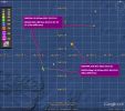
They just had a 4.1 aftershock off the coast of Vancouver, so here are the 3 quakes. Looks like they are moving east. [uphill?]
neic.usgs.gov...
I took a look at a plate chart and there was a smaller plate called the "explorer" above the Juan de fuca.
To me it looks like these are on the explorer plate, but you folks would know for sure.
neic.usgs.gov...
I took a look at a plate chart and there was a smaller plate called the "explorer" above the Juan de fuca.
To me it looks like these are on the explorer plate, but you folks would know for sure.
reply to post by wasobservingquietly
Thanks for the pointer to the Geysers. It made me realise that the 7 day listing I use does not differentiate that and calls it all Northern California so I have had to create a box for it.
Makes me more determined that I must get round to writing the code for a swarm detector one day - I think I called it a swarmalyser the other day.
reply to post by Aircooled
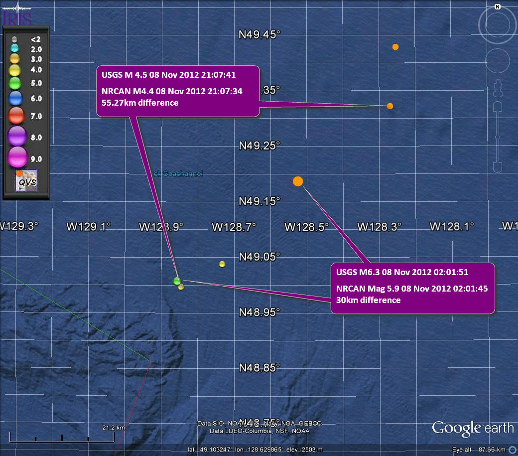
I guess the problem here is that who do you believe? The USGS and Canada have very different positions for two of these quakes and the third is not on Canada yet.
These would seem to be within the Explorer plate. This page on the west valley segment of the JDF plate is about a 2001 swarm in that same area. Note one sentence:
Emphasis is mine.
Also, a bit splattered with dots...
You can just make out the explorer plate on the image.
Here is some better detail on the JDF microplate(s)
I guess the problem here is that who do you believe? The USGS and Canada have very different positions for two of these quakes and the third is not on Canada yet.
These would seem to be within the Explorer plate. This page on the west valley segment of the JDF plate is about a 2001 swarm in that same area. Note one sentence:
After the initial event, activity increased and epicenters propagated southward to within 5 km of known hydrothermal vents and drill holes
Emphasis is mine.
Also, a bit splattered with dots...
You can just make out the explorer plate on the image.
Here is some better detail on the JDF microplate(s)
edit on 10/11/2012 by PuterMan because: (no reason given)
Turkey looks so busy I could start a new thread suggesting Iran has a HAARP of its own. ROFL
I have never seen it quite this busy.
P
I have never seen it quite this busy.
P
Originally posted by crappiekat
Mobile Bay, Mississippi. 2.7, 5km = 3 miles,188.........
Right outside that bay. I don;t think I've seen anything there before.
I've been watching this area more than most because of the sinkhole situation in Bayou Corne, LA. I know this is Mississippi.
Could this be connected? I've been following the other threads about, LA, and I gotta say, it sounds kinda spooky down there.
Any thoughts?
This freaks me out too. The coordinates for the Deepwater incident are 28N 88W. This earthquake (30.111°N, 88.073°W) is about 120 miles from that location. For reference the coordinates of the sinkhole are 30.0146° N, 91.1551° W. I don't know half what a lot of you guys know on this thread. But my woman's intuition tells me something is happening in this area and it's not good. PuterMan any ideas?
edit on 10-11-2012 by FreebirdGirl
because: (no reason given)
edit on 10-11-2012 by FreebirdGirl because: (no reason given)
edit on 10-11-2012 by
FreebirdGirl because: (no reason given)
Not connected with anything in particular but as I was browsing and wilfing on from the JDF plate I came across this map of
The Oil and Gas Wells of West Virginia
The mass of colour is made up of tiny dots and each dot is a well. Drag the cursor across the map to zoom in on an area.
There are a mind boggling amount oil/gas wells in that patch!
The mass of colour is made up of tiny dots and each dot is a well. Drag the cursor across the map to zoom in on an area.
There are a mind boggling amount oil/gas wells in that patch!
new topics
-
Who guards the guards
US Political Madness: 1 hours ago -
Has Tesla manipulated data logs to cover up auto pilot crash?
Automotive Discussion: 3 hours ago -
whistleblower Captain Bill Uhouse on the Kingman UFO recovery
Aliens and UFOs: 8 hours ago -
1980s Arcade
General Chit Chat: 10 hours ago -
Deadpool and Wolverine
Movies: 11 hours ago
top topics
-
Lawsuit Seeks to ‘Ban the Jab’ in Florida
Diseases and Pandemics: 15 hours ago, 20 flags -
Starburst galaxy M82 - Webb Vs Hubble
Space Exploration: 17 hours ago, 13 flags -
CIA botched its handling of sexual assault allegations, House intel report says
Breaking Alternative News: 13 hours ago, 8 flags -
15 Unhealthiest Sodas On The Market
Health & Wellness: 17 hours ago, 6 flags -
whistleblower Captain Bill Uhouse on the Kingman UFO recovery
Aliens and UFOs: 8 hours ago, 6 flags -
1980s Arcade
General Chit Chat: 10 hours ago, 4 flags -
Deadpool and Wolverine
Movies: 11 hours ago, 4 flags -
Teenager makes chess history becoming the youngest challenger for the world championship crown
Other Current Events: 12 hours ago, 3 flags -
Who guards the guards
US Political Madness: 1 hours ago, 1 flags -
Has Tesla manipulated data logs to cover up auto pilot crash?
Automotive Discussion: 3 hours ago, 0 flags
active topics
-
Candidate TRUMP Now Has Crazy Judge JUAN MERCHAN After Him - The Stormy Daniels Hush-Money Case.
Political Conspiracies • 622 • : Lazy88 -
Scientists Say Even Insects May Be Sentient
Science & Technology • 55 • : AdultMaleHumanUK -
"We're All Hamas" Heard at Columbia University Protests
Social Issues and Civil Unrest • 201 • : TheWoker -
-@TH3WH17ERABB17- -Q- ---TIME TO SHOW THE WORLD--- -Part- --44--
Dissecting Disinformation • 610 • : Justoneman -
Lawsuit Seeks to ‘Ban the Jab’ in Florida
Diseases and Pandemics • 24 • : VariedcodeSole -
23,000 Dead People Registered Within a Two Week Period In One State
US Political Madness • 40 • : IndieA -
whistleblower Captain Bill Uhouse on the Kingman UFO recovery
Aliens and UFOs • 7 • : pianopraze -
CIA botched its handling of sexual assault allegations, House intel report says
Breaking Alternative News • 6 • : watchitburn -
They Killed Dr. Who for Good
Rant • 63 • : grey580 -
House Overwhelmingly Passes Funding for Ukraine, Israel and Taiwan
US Political Madness • 58 • : IndieA