It looks like you're using an Ad Blocker.
Please white-list or disable AboveTopSecret.com in your ad-blocking tool.
Thank you.
Some features of ATS will be disabled while you continue to use an ad-blocker.

Quake Watch 2012
page: 253share:
reply to post by MonkeyFishFrog
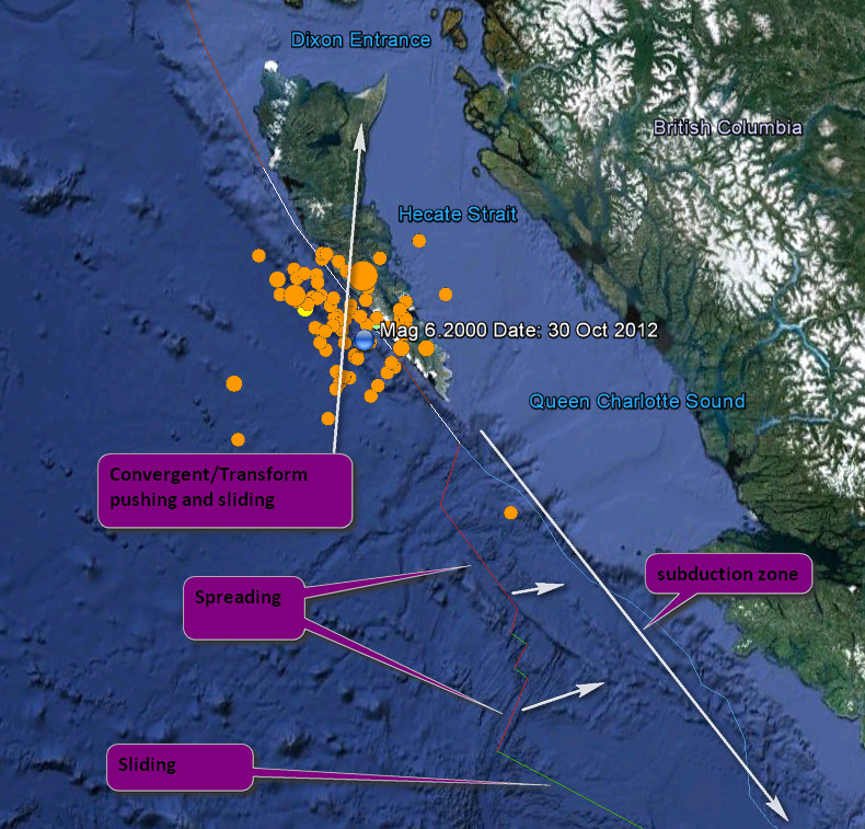
When you refer to the fault lines of the Pacific plate could you be a bit more specific? The Pacific plate is vast stretching down to New Zealand. NZ has seen some recent activity, as has Vanuatu.
I am guessing that you are are meaning the southern part of the plate as relates to North America, which is only a small edge of the plate in the grand scheme.
There is a difference between the subducting plate boundary against Canada/USA(Washington,Oregon, and just into Northern California), and the southern section which is that transform fault of the San Andreas. Narrowing it further I will take it that you are actually meaning the southern end of the Cascadia subduction zone, which has had a few recently but granted not the same intensity as this current activity on the Northern end - although the actual area active at present is just beyond the subduction zone and is a convergent/transform boundary meaning it is coming together and sliding past in simplest terms.
This is just my uneducated take on the sort of movements going on in the area and I am guessing the directions without looking them up *smack*

Some of this stress will be transferred further down, but may have little immediate effect. We are not seeing subduction zone movement here but hey I am not the one to be talking about this. Mr Vidale, if you are cruising past, perhaps would chip in with your extensive knowledge of the actions in this area.
When you refer to the fault lines of the Pacific plate could you be a bit more specific? The Pacific plate is vast stretching down to New Zealand. NZ has seen some recent activity, as has Vanuatu.
I am guessing that you are are meaning the southern part of the plate as relates to North America, which is only a small edge of the plate in the grand scheme.
There is a difference between the subducting plate boundary against Canada/USA(Washington,Oregon, and just into Northern California), and the southern section which is that transform fault of the San Andreas. Narrowing it further I will take it that you are actually meaning the southern end of the Cascadia subduction zone, which has had a few recently but granted not the same intensity as this current activity on the Northern end - although the actual area active at present is just beyond the subduction zone and is a convergent/transform boundary meaning it is coming together and sliding past in simplest terms.
This is just my uneducated take on the sort of movements going on in the area and I am guessing the directions without looking them up *smack*
Some of this stress will be transferred further down, but may have little immediate effect. We are not seeing subduction zone movement here but hey I am not the one to be talking about this. Mr Vidale, if you are cruising past, perhaps would chip in with your extensive knowledge of the actions in this area.
edit on 30/10/2012 by PuterMan because: Ah, the inevitable speeling erra
reply to post by PuterMan
Thank you for your reply. Next time I will try to make sure that I am a bit more specific but you were dead on with the area I was referring to. I live in the Cascadia Subduction Zone and was worried about the activity we're seeing along the Queen Charlotte fault.
Thank you for your reply. Next time I will try to make sure that I am a bit more specific but you were dead on with the area I was referring to. I live in the Cascadia Subduction Zone and was worried about the activity we're seeing along the Queen Charlotte fault.
Just me noting a cluster.
29th, 4 quakes within 10hours.
18+ hours without one
other reading
1. "Don't panic."
In other words, (the boy scout's words), "be prepared."
www.vancouversun.com...
adding...
www.youtube.com...
I found the movie Uncanny. Thank you you tube.
Most times earthquakes cause little damage or injury. But, they can scare you to death. So, again, don't panic.
www.sciencefriday.com...
29th, 4 quakes within 10hours.
18+ hours without one
other reading
1. "Don't panic."
In other words, (the boy scout's words), "be prepared."
www.vancouversun.com...
edit on 30-10-2012 by ericblair4891 because: (no reason given)
adding...
www.youtube.com...
I found the movie Uncanny. Thank you you tube.
Most times earthquakes cause little damage or injury. But, they can scare you to death. So, again, don't panic.
www.sciencefriday.com...
edit on 30-10-2012 by ericblair4891 because: (no reason given)
4.9/5.3/5.2 quake 15 km west of Te Kaha, East Cape New Zealand, depending who you read.
Geonet 4.9ML in the Bay of Plenty
GFZ 5.3mb
UGS 5.2mb
both UGS and GFZ seem confused as to what is offshore and onshore "Off E. Coast of N. Island, N.Z." when
the quake was on land in those 2 cases
EMSC have it 5.2mb 100km to the east actually off the East Coast
just for the record, because they are bound to change it later
Geonet 4.9ML in the Bay of Plenty
GFZ 5.3mb
UGS 5.2mb
both UGS and GFZ seem confused as to what is offshore and onshore "Off E. Coast of N. Island, N.Z." when
the quake was on land in those 2 cases
EMSC have it 5.2mb 100km to the east actually off the East Coast
edit
on 30-10-2012 by muzzy because: got a ] wrong
just for the record, because they are bound to change it later
UGS=5.2 2012/10/30 13:12:29 -37.949 177.681 67.8 OFF EAST COAST OF THE NORTH ISLAND, N.Z.
GFZ=2012-10-30 13:12:29 5.3 37.91°S 177.64°E 50 M Off E. Coast of N. Island, N.Z.
edit on 30-10-2012 by muzzy because: (no reason
given)
reply to post by muzzy
Was wondering the same thing read off shore but when i looked at the map saw it was on land lol
Was wondering the same thing read off shore but when i looked at the map saw it was on land lol
Deep boom heard coming from underground in Los Angeles.
Was heard at 6:48 pm this evening pacific time. Was strong enough to rattle some windows here.
repost from this thread
www.abovetopsecret.com...
Was heard at 6:48 pm this evening pacific time. Was strong enough to rattle some windows here.
repost from this thread
www.abovetopsecret.com...
Originally posted by lurksoften
reply to post by dreamfox1
any links from local media covering this curious......
As of yet ....nothing but silence from the media.
Still very quiet along Japan fault-lines...seems ominous to me given that most other regions are showing some regular activity, except for Japan.
My 14 day window prediction for a 7+ happening there soon, was made just prior to the 7.7 Queen Charlotte quake. I'm counting down to the 7th of November for my prediction to either happen or expire. Hopefully the later of course, but all this 'quietness' there, worries me.
My 14 day window prediction for a 7+ happening there soon, was made just prior to the 7.7 Queen Charlotte quake. I'm counting down to the 7th of November for my prediction to either happen or expire. Hopefully the later of course, but all this 'quietness' there, worries me.
Originally posted by muzzy
reply to post by Ironclad
Geez Mate, there isn't a quieter place in the World for earthquakes and erupting volcanoes than Australia.
If you can put up with the Fires and the Flies and the PM, I'd be counting my blessings and just get on with the Rugby training
400 quakes since the 5.6 eh?
A link to this data anywhere ?
edit on 27-10-2012 by muzzy because: (no reason given)
Your're kidding right?
Try looking up Australian Volcanoes and Fault Lines and Yea there are plenty of links and data on the Gippy quake and the 100's of small aftershocks since (do a search yourself)..
Didn't you even read my first post?
Thee are over 40 potential active Volcanoes across Victoria and Eastern SA. They include Mount Gambier (a Marr Volcano which is around 2000 years overdue), Mt Macedon (A Cone Volcanoe), actually Macedon and Hanging Rock are a two-for (one being a inactive shield and the other as I said, a cone), Mount Major, Aberfeldy and a host of others.
Also I did state that Victoria is in an "Active", mountain building stage and the ranges in Southern Gippsland (south of Moe/Trafalgar and the Souther part of the Tarra Bulga), has risen nearly 10m in the last 100,000 years. The Mornington Peninsula has risen 16 meters in the same time.The faults in Gippy are thrust faults or stress faults, meaning that as magma and pressure push the crust upward in weak/exposed spots to form mountains. When the pressure hits a brittle spot of "say Shale and Granite, rather than more pliable materials", They can crack open and form large faults.
Recent quakes in this area have been at 0.0km depth...!!
Dunno where you get your info from that AU is the safest place in the world, cause your dead wrong!! It's as active as any country with multiple volcanoes, just because they havn't errupted since folks have lived here don't mean they cant or won't..
While most AU most recent Volcanoes are classed as "inactive", the are far deom dead...
There are over 400 already dead Volcanoes across Vic and then the fourty or so that are in-active. The last erruption were at Gambier 5000 years ago and Aberfeldy, around 12,000 years, there are a few other recent erruptions, but I can't remember them off the top of my head.
And YES, 5000 years and 12000 years can be considered very recent in terms of age and activity. Victorias oldest and extinct volcanoes became extinct when continental drift, moved them away from the active zone over several million years. The most recent volcanoes however have moved only a few 100 meters and are still very much over the active points.
You really need to research before you comment on posts, by ppls who actually know something about what they are talking..lol
Growing up, mom and dad and maybe your primary school trachers might have told you that australia is the safest place on earth. They prolly didn't know any better. But the reality is that AU has the potential to outshine any other major volcanic provence on the planet, due to the fact that many of our volcanoes are in heavily populated areas. The potential for loss of life is much greater than other places, whos inhabitance know better than to build a house on top of a keg of TNT.
edit on 10/31/2012 by Ironclad because: (no reason given)
Originally posted by PuterMan
reply to post by Mister1k
OK, you have (yet another) thread on the (supposed) plate break up. Define precisely which part is breaking from which please, preferably with a properly marked up diagram, because all the BS I have seen before now is talking about a boundary that already exists. The so called Indo-Australian plate is two plates the Australian plate and the Indian plate, as I have pointed out in this thread before.
Sure not a problem, since you must have read a little on my only thread on the subject. Just thought I would chime in here. So you must have read the Science News article with the diagram.Here>
and here is the NEW plate diagram.Bottom of the page.Science News-Tectonic And I'll quote from the article.
Seven huge plates dominate the plate tectonic scene. At least eight smaller plates show up on most maps, mostly on the margins of oceans where Earth’s crust is thinner and more prone to fracture. But some of these plates, big and small, are in the process of breaking up (see main story), and in a few cases may have already done so. Several scientists argue that the Indo-Australian plate, which is the third largest plate and is in the midst of a drawn-out breakup, has already shed one fragment, a smaller plate dubbed Capricorn, on its southwest edge. Global-positioning satellite data show that the southwest part of the larger plate is not moving in exactly the same direction as the northwest and east. That, some geologists argue, suggests that Capricorn has already broken away.
I've seen a lot of maps with a separate Indian and Australian plates,but the consensus is the Indo-Australian plate is the third largest plate.All the software out there Eq3d, xquake, shows one single plate as well.
Data glitches? I think not. JMHO.
Station 46403, 52.3 north latitude in Alaska buoy, has had two separate events since yesterday.
The 7.7 Queen Charlotte quake epicenter lies on 52.7 north latitude.
Was it giving glitchy data too?
This smells just like Japan.
March 09,2011 7.3 Japan, swarm for a day and a half,quiet for half a day and then bang March 11th the 9 pointer not far from the 7.3 location.
78 quakes at Queen Charlotte location since the 7.7,with a couple 6s and nothing under a 4.0, nothing! Last quake lunch time yesterday. There was also a buoy event preceding this 7.7 quake.Archived.
Just a hunch call it then,but the West Coast is vulnerable in my opinion.
2.5M Missouri. IT comes about 42 hours after the 10 hour period which saw four good thumps. My cluster studies are sporatic, narrow, and not
comprehensive. This is why I admire Muzzy's and Puter's efforts. It's not that I'm not keeping track. It's that I'm lazy- just like math teachers
said. I always got the answer but never showed my worked. Hell, (oh, happy halloween everyone- tommorow I'll be one year old- it was last halloween
robin bit the dust) Hell, I never even kept a notebook as required. I even passed grade 10 English when I failed to had in the Hamlet essay. At the
begining of the year, Mr. Z said it was impossible to pass his course without handing it in. I did the impossible.
My tangent is even annoying me. So. I will keep a crude timetable as to whether or not the east is in an on, or off position. I'll be watching more intently because me thinks the off again on again pattern of quakes - shhh-
I think eastern Alaska and the Yukon in Canada are replying to the shakes coming from Haidi Gwaii.
www.theglobeandmail.com...
adding
The Italian 6 is not a simple case. I still can see both sides of the argument and the issues are complex. In 1938 a hurricane hit New England. The weather service took no responsibility and said even if they had released a warning, "New Englanders would listened because they weren't hurricane educated like those folks in Florida." I'm paraphrasing. The issue is not about not predicting the exact magnitude and location and time of the quake. It is about educating the public, assessing risk and provide current and new information and data as it becomes available.
Again, on the surface the case seems ludicrious. But, what happens if the earhquake happen in the southeast United States right near an injection well? Shouldn't the geologists and public officals be held accountable?
In the Italian decision I stll think a jail sentence is wrong. The officials were not being completely negligent. They were being arrogant and difficult. That's cause for dismissal only.
Here's another argument for the defence to use. Suppose they did issue a warning. And let's say the people were on the verge of panic, lives were disrupted and peopled stressed. This can cause death. Old peoples don't move so well. Let's say the officals spent the money and made plans for an disaster to come. And let's say, nothing happened.
Would you gamble and decided to act as if the earthquake was certain to come in a specific time period?
No. You don't panic. You educate yourself and make a emergency plan that fits all emergencies. And if there is an earthquake risk. You continue to make buildings earthquake ready. Because if you live in an earthquake region there should be constant retrofitting of older buildings. A place like Italian where buildings are ancient, this activity should keep the whole country employed.
Anyway, I'm glad for the verdict. Yes, I think the officals are going through hell. I'm not forgetting their personal plights. But this is a professional debate that needs to happen and happen now. Cascadia anyone? Fracking in siesmic zones anyone? When the risks are ignored, I want to know who's going to be held accountable.
www.huffingtonpost.com...
Here's something frightening for all hallow's eve.
www.desmogblog.com...
I just realized I live in the most spoiled country in the world. Don't get me wrong. I love my country. Even sworn and oath and did a bit of basic training for our queen. Oh, Canada, I stand on guard for thee. But, we are stinking rich. Our biggest trouble is getting the money to flow fast enough. We're trying to build more tubes to keep the black goo moving. WE NEED MORE PIPELINES. Gosh. This is all I'm hearing about. That and the strike. The commercials. I used to not have a tv. now i do. ug.(i know i could not watch- but it's part of the study, i need to know how it's changed.) The oil sands commercials are repugnant. Oil sand is apparently a magically substance. Because somehow it's transforming Canada and solving all bad things. I swear I even heard it said that oil sands make rainbows. Wait, I say that. Whenever I hear that oil sands give some much back to the community. Yup, that fish sure has some extra stuff in it when the First Peoples catch them downstream. Ummm, you can really tatse the cancers in the metro-sexual fish.
stop robin.
yes, mother.
might watch pyscho tonight.
my mom stop showering when she saw it when it first played. from then on, she only took baths
My tangent is even annoying me. So. I will keep a crude timetable as to whether or not the east is in an on, or off position. I'll be watching more intently because me thinks the off again on again pattern of quakes - shhh-
I think eastern Alaska and the Yukon in Canada are replying to the shakes coming from Haidi Gwaii.
www.theglobeandmail.com...
adding
The Italian 6 is not a simple case. I still can see both sides of the argument and the issues are complex. In 1938 a hurricane hit New England. The weather service took no responsibility and said even if they had released a warning, "New Englanders would listened because they weren't hurricane educated like those folks in Florida." I'm paraphrasing. The issue is not about not predicting the exact magnitude and location and time of the quake. It is about educating the public, assessing risk and provide current and new information and data as it becomes available.
Again, on the surface the case seems ludicrious. But, what happens if the earhquake happen in the southeast United States right near an injection well? Shouldn't the geologists and public officals be held accountable?
In the Italian decision I stll think a jail sentence is wrong. The officials were not being completely negligent. They were being arrogant and difficult. That's cause for dismissal only.
Here's another argument for the defence to use. Suppose they did issue a warning. And let's say the people were on the verge of panic, lives were disrupted and peopled stressed. This can cause death. Old peoples don't move so well. Let's say the officals spent the money and made plans for an disaster to come. And let's say, nothing happened.
Would you gamble and decided to act as if the earthquake was certain to come in a specific time period?
No. You don't panic. You educate yourself and make a emergency plan that fits all emergencies. And if there is an earthquake risk. You continue to make buildings earthquake ready. Because if you live in an earthquake region there should be constant retrofitting of older buildings. A place like Italian where buildings are ancient, this activity should keep the whole country employed.
Anyway, I'm glad for the verdict. Yes, I think the officals are going through hell. I'm not forgetting their personal plights. But this is a professional debate that needs to happen and happen now. Cascadia anyone? Fracking in siesmic zones anyone? When the risks are ignored, I want to know who's going to be held accountable.
edit on 31-10-2012 by ericblair4891 because: (no reason given)
www.huffingtonpost.com...
edit on 31-10-2012 by ericblair4891 because: (no reason given)
Here's something frightening for all hallow's eve.
www.desmogblog.com...
edit on 31-10-2012 by ericblair4891 because: (no reason given)
I just realized I live in the most spoiled country in the world. Don't get me wrong. I love my country. Even sworn and oath and did a bit of basic training for our queen. Oh, Canada, I stand on guard for thee. But, we are stinking rich. Our biggest trouble is getting the money to flow fast enough. We're trying to build more tubes to keep the black goo moving. WE NEED MORE PIPELINES. Gosh. This is all I'm hearing about. That and the strike. The commercials. I used to not have a tv. now i do. ug.(i know i could not watch- but it's part of the study, i need to know how it's changed.) The oil sands commercials are repugnant. Oil sand is apparently a magically substance. Because somehow it's transforming Canada and solving all bad things. I swear I even heard it said that oil sands make rainbows. Wait, I say that. Whenever I hear that oil sands give some much back to the community. Yup, that fish sure has some extra stuff in it when the First Peoples catch them downstream. Ummm, you can really tatse the cancers in the metro-sexual fish.
stop robin.
yes, mother.
might watch pyscho tonight.
my mom stop showering when she saw it when it first played. from then on, she only took baths
edit on 31-10-2012 by ericblair4891 because: (no reason given)
Originally posted by ericblair4891
... (oh, happy halloween everyone- tommorow I'll be one year old- it was last halloween robin bit the dust) ...
Happy Anniversary Eric! And a spooky Halloween to you and all of ATS.
Oh yeah, another small EQ out toward the spreading ridge of the Gorda Plate, offshore, Oregon. USGS mag 4.2
reply to post by Mister1k
The problem is that the area that shows where the break up is supposed to be occurring already has a plate boundary AS I have showed before.
Yes I have read the the thread and I have read the papers and it is BS as far as I am concerned as there is no Indo -Australian plate but 2 plates the Indian plates and the Australian plate.
that does not make it right. Programmers program what they are told to program, unless they are analyst programmers, and programmers make mistakes as well. I know because I am one.
No one is denying that!!
The problem is that the area that shows where the break up is supposed to be occurring already has a plate boundary AS I have showed before.
Yes I have read the the thread and I have read the papers and it is BS as far as I am concerned as there is no Indo -Australian plate but 2 plates the Indian plates and the Australian plate.
All the software out there Eq3d, xquake, shows one single plate as well.
that does not make it right. Programmers program what they are told to program, unless they are analyst programmers, and programmers make mistakes as well. I know because I am one.
Just a hunch call it then,but the West Coast is vulnerable in my opinion.
No one is denying that!!
edit on 31/10/2012 by PuterMan because: (no reason given)
reply to post by PuterMan
Hmm...so I jumped on here to get yours and any others opinion that want to give it, on the relative quiet in the Queen Charlotte swarm.
First...I want to point out there there HAVE been quakes under 4.0, they just don't list them on the USGS map. having said that, I find it rather disturbing that there was a nice regular rythm going of after-shocks above 4.0 since the 7.7,,,,,,,until yesterday at 10:30am. That last quake, a 4.0 was also the most shallow of the swarm at less than a mile deep. Puterman, I recall a trending of the shocks in Japan right before the big one of them getting shallower....do you have that info handy?? I'll go digging if not.
What do you think about it? The closest station I can get on GEE hasn't shown anything for close to 24 hrs. The local canadian ones are showing lots of 'noise', but obviously nothing bigger than a 3 or so. The canadian site is WAY behind on listing their quakes.
reply to post by westcoast
What was curious was that those 2 4's were up in central alaska and had some 3's and 2's mixed in there.
Not sure about smaller eq but not many larger than 3's in the area of that 7.7 since about 24hours ago.
But there was that 6.2 yesterday i believe followed by a 5.0.
What was curious was that those 2 4's were up in central alaska and had some 3's and 2's mixed in there.
Not sure about smaller eq but not many larger than 3's in the area of that 7.7 since about 24hours ago.
But there was that 6.2 yesterday i believe followed by a 5.0.
reply to post by westcoast
Hey Westcoast
I've been watching Bella Bella, BC in GEE, and only noticed 2 or possibly 3 small rumbles from Queen Charlotte today. They looked really small, though--my guess was 2.5-3.0 range. The abrupt shut-off of 4-5 range quakes is an eyebrow raiser.
Keep watching...
Hey Westcoast
I've been watching Bella Bella, BC in GEE, and only noticed 2 or possibly 3 small rumbles from Queen Charlotte today. They looked really small, though--my guess was 2.5-3.0 range. The abrupt shut-off of 4-5 range quakes is an eyebrow raiser.
Keep watching...
Darn. I knew they'd slip in a tiny quake that I didn't see. Tennessee 1.5M . I would go mad trying to catalouge and having to update and change all
the revisions. I couldn't even find the tiny thing on the siesmo helicoders.
reply to post by westcoast
Well you know first off I would say that it is not a swarm. This was a clear mainshock and a few good aftershocks whereas to my way of thinking a swarm has no initial main shock and generally the quakes are low end of similar sizes. That is just my take on it.
On the assumption that it is a mainshock and aftershocks I think the problem for us is as you say that USGS does not list under Mag 4. I don't have any historical data that would have the low end values after a similar size main shock. Noted that Canada are playing it cautious in their promulgation of quakes so it may be a while before we get a better picture. The last quakes I have were before 0642 UTC and the last one for that area was 0310 UTC so there must be some catching up to do.
This data comes from the JSON file and differs from the web site sometimes.
There was a Mag 6.3 in September of last year and the aftershocks were all small. I am posting the list in another post as there is not enough room in this one.
the Queen Charlotte swarm
Well you know first off I would say that it is not a swarm. This was a clear mainshock and a few good aftershocks whereas to my way of thinking a swarm has no initial main shock and generally the quakes are low end of similar sizes. That is just my take on it.
On the assumption that it is a mainshock and aftershocks I think the problem for us is as you say that USGS does not list under Mag 4. I don't have any historical data that would have the low end values after a similar size main shock. Noted that Canada are playing it cautious in their promulgation of quakes so it may be a while before we get a better picture. The last quakes I have were before 0642 UTC and the last one for that area was 0310 UTC so there must be some catching up to do.
Prov,Date/Time UTC,Latitude,Longitude,Magnitude,Depth(Km),Location
nrcan,2012-10-30 03:10:38, 52.730, -132.880, 3.1, 20.0, 91 Km Wsw Of Sandspit Bc
nrcan,2012-10-30 03:08:28, 52.910, -132.360, 2.9, 20.0, 52 Km Wsw Of Sandspit Bc
nrcan,2012-10-30 02:55:08, 52.220, -132.120, 4.8, 19.2, 116 Km Ssw Of Sandspit Bc
nrcan,2012-10-30 02:48:58, 52.130, -132.320, 5.6, 18.6, 129 Km Ssw Of Sandspit Bc
nrcan,2012-10-28 23:24:36, 52.510, -132.200, 4.1, 13.9, 86 Km Ssw Of Sandspit Bc
nrcan,2012-10-28 18:54:16, 52.480, -132.790, 6.3, 20.0, 107 Km Sw Of Sandspit Bc. [F]
nrcan,2012-10-28 14:41:00, 52.500, -132.340, 3.9, 18.4, 90 Km Sw Of Sandspit Bc
nrcan,2012-10-28 13:09:12, 52.250, -132.170, 4.7, 28.6, 114 Km Ssw Of Sandspit Bc
nrcan,2012-10-28 06:16:48, 52.190, -131.260, 5.2, 2.8, 123 Km Sse Of Sandspit Bc
nrcan,2012-10-28 05:47:02, 52.220, -131.660, 4.4, 1.0, 115 Km S Of Sandspit Bc
nrcan,2012-10-28 05:21:31, 52.390, -131.820, 4.3, 30.1, 95 Km S Of Sandspit Bc
nrcan,2012-10-28 05:15:09, 52.190, -132.260, 4.4, 21.4, 121 Km Ssw Of Sandspit Bc
nrcan,2012-10-28 04:53:14, 52.640, -131.970, 4.3, 1.0, 68 Km Ssw Of Sandspit Bc
nrcan,2012-10-28 04:51:47, 52.530, -132.060, 4.3, 12.5, 81 Km Ssw Of Sandspit Bc
nrcan,2012-10-28 04:49:10, 52.480, -131.880, 4.4, 15.8, 86 Km S Of Sandspit Bc
nrcan,2012-10-28 04:40:58, 52.350, -132.340, 5.1, 10.0, 106 Km Ssw Of Sandspit Bc
nrcan,2012-10-28 04:29:49, 52.520, -131.800, 3.7, 20.0, 81 Km S Of Sandspit Bc
nrcan,2012-10-28 04:21:52, 52.520, -131.850, 4.0, 20.0, 80 Km S Of Sandspit Bc
nrcan,2012-10-28 03:52:18, 52.320, -132.020, 4.7, 20.0, 104 Km Ssw Of Sandspit Bc
nrcan,2012-10-28 03:38:10, 52.510, -132.030, 4.5, 20.0, 83 Km Ssw Of Sandspit Bc
nrcan,2012-10-28 03:32:39, 52.520, -131.780, 4.2, 20.0, 81 Km S Of Sandspit Bc
nrcan,2012-10-28 03:04:06, 52.560, -132.290, 7.7, 20.0, 83 Km Sw Of Sandspit Bc. [F]
nrcan,2012-10-25 09:15:24, 53.170, -132.880, 3.2, 20.0, 71 Km W Of Sandspit Bc
This data comes from the JSON file and differs from the web site sometimes.
There was a Mag 6.3 in September of last year and the aftershocks were all small. I am posting the list in another post as there is not enough room in this one.
new topics
-
VP's Secret Service agent brawls with other agents at Andrews
Mainstream News: 51 minutes ago -
Sunak spinning the sickness figures
Other Current Events: 1 hours ago -
Nearly 70% Of Americans Want Talks To End War In Ukraine
Political Issues: 1 hours ago -
Late Night with the Devil - a really good unusual modern horror film.
Movies: 3 hours ago -
Cats Used as Live Bait to Train Ferocious Pitbulls in Illegal NYC Dogfighting
Social Issues and Civil Unrest: 4 hours ago -
The Good News According to Jesus - Episode 1
Religion, Faith, And Theology: 6 hours ago -
HORRIBLE !! Russian Soldier Drinking Own Urine To Survive In Battle
World War Three: 8 hours ago -
Bobiverse
Fantasy & Science Fiction: 11 hours ago -
Florida man's trip overseas ends in shock over $143,000 T-Mobile phone bill
Social Issues and Civil Unrest: 11 hours ago
top topics
-
Florida man's trip overseas ends in shock over $143,000 T-Mobile phone bill
Social Issues and Civil Unrest: 11 hours ago, 8 flags -
SETI chief says US has no evidence for alien technology. 'And we never have'
Aliens and UFOs: 15 hours ago, 7 flags -
Cats Used as Live Bait to Train Ferocious Pitbulls in Illegal NYC Dogfighting
Social Issues and Civil Unrest: 4 hours ago, 7 flags -
VP's Secret Service agent brawls with other agents at Andrews
Mainstream News: 51 minutes ago, 4 flags -
Former Labour minister Frank Field dies aged 81
People: 14 hours ago, 4 flags -
HORRIBLE !! Russian Soldier Drinking Own Urine To Survive In Battle
World War Three: 8 hours ago, 3 flags -
Bobiverse
Fantasy & Science Fiction: 11 hours ago, 3 flags -
Nearly 70% Of Americans Want Talks To End War In Ukraine
Political Issues: 1 hours ago, 3 flags -
Sunak spinning the sickness figures
Other Current Events: 1 hours ago, 3 flags -
Late Night with the Devil - a really good unusual modern horror film.
Movies: 3 hours ago, 2 flags
active topics
-
The Reality of the Laser
Military Projects • 42 • : Zaphod58 -
President BIDEN Vows to Make Americans Pay More Federal Taxes in 2025 - Political Suicide.
2024 Elections • 121 • : Zanti Misfit -
HORRIBLE !! Russian Soldier Drinking Own Urine To Survive In Battle
World War Three • 27 • : RickyD -
Nearly 70% Of Americans Want Talks To End War In Ukraine
Political Issues • 7 • : Consvoli -
Sunak spinning the sickness figures
Other Current Events • 1 • : Justoneman -
Mood Music Part VI
Music • 3100 • : TheDiscoKing -
VP's Secret Service agent brawls with other agents at Andrews
Mainstream News • 12 • : xuenchen -
Ditching physical money
History • 19 • : 20241105 -
Breaking Baltimore, ship brings down bridge, mass casualties
Other Current Events • 484 • : ThatSmellsStrange -
SETI chief says US has no evidence for alien technology. 'And we never have'
Aliens and UFOs • 39 • : SchrodingersRat