It looks like you're using an Ad Blocker.
Please white-list or disable AboveTopSecret.com in your ad-blocking tool.
Thank you.
Some features of ATS will be disabled while you continue to use an ad-blocker.

Quake Watch 2012
page: 251share:
Originally posted by muzzy
here is Oct, centred on the 5.0 goo.gl...
zoom out and have a look around, there are little swarms all over the place, L'Aqulla still twitching, as is Emilia-Romagna
I'll go ahead and split those Pollino quakes into fore and after shocks and do a page on it during the week.
My apologies for being so eager to get this out without cross checking it.
Now when I split the Oct file into before and after the Pollino 5.0 I see that some of the location names don't match where they actually are, there are Pollino names on some of the L'Aquilla icons for example.
This must have been at one stage where I used the "sort" filter and missed selecting the "where" column that has the location address.
Sorry about that
The icons are in the right spots, Lat/Long and the mags and TTNT are right, its just the addresses may be wrong.
Human error
I was trying to sort by name but its too hard as the Italian addresses start with a street name rather than the nearest town (or Park in this case)
I've started filtering it by Lat and Long and eliminate those outside the box area.
edit on 28-10-2012 by muzzy because: (no reason
given)
WOW 6.4 after shock again
just a bit west of the 7.7
Starting to think the next one will be bigger 90% change i give it
just a bit west of the 7.7
Starting to think the next one will be bigger 90% change i give it
edit on 28-10-2012 by Trillium because: (no reason given)
The depths of these 2 recent aftershocks are different from the vast majority of the preceding events. The average depth of all the other
earthquakes in the vicinity has been around 10.1 km; with one as shallow as 7.7 km and the previous deepest EQ was the Mag 7.7 at 17.5 km depth.
source
That area seems to be undergoing some serious ripping and rearranging.
Here is the spectrogram from the Campbell River, BC station, which I believe is over 350 km away from the center of this earthquake activity.
Very energetic past 16+ hours...
Ack! Add an even deeper aftershock to the list-- 47.2 km depth:
(same source as above)
M Location TimeUTC Lat Lon D km
5.2 134km SSW of Masset, Canada 2012-10-28 19:16:51 52.844°N 132.605°W 20.0
5.4 151km SSW of Masset, Canada 2012-10-28 19:03:24 52.742°N 132.901°W 32.8
source
That area seems to be undergoing some serious ripping and rearranging.
Here is the spectrogram from the Campbell River, BC station, which I believe is over 350 km away from the center of this earthquake activity.
Very energetic past 16+ hours...
edit on 10/28/2012 by Olivine because: forgot source of quote, and I added a pic link.
Ack! Add an even deeper aftershock to the list-- 47.2 km depth:
5.1 166km S of Masset, Canada 2012-10-28 19:16:55 52.544°N 132.580°W 47.2
(same source as above)
edit on 10/28/2012 by Olivine because: (no reason given)
Wondering where everyone is? Worried and stressed a bit, need factual data that I can understand in lamans terms...
Originally posted by antar
Wondering where everyone is? Worried and stressed a bit, need factual data that I can understand in lamans terms...
Maybe overhere
www.abovetopsecret.com...
or it the east coast evacuation
edit on 28-10-2012 by Trillium because: (no reason given)
reply to post by Trillium
Thanks Trill, I did find that one thank you, this one sometimes seems to have less banter/speculation and more current updates thats all.
Stay alert/Safe
Thanks Trill, I did find that one thank you, this one sometimes seems to have less banter/speculation and more current updates thats all.
Stay alert/Safe
Other than the Canadian after-shocks, the rest of the world seems awfully quiet at present.
Hopefully that's a good thing?
Hopefully that's a good thing?
A little while ago, I posted in the other thread a list of the quake & aftershocks thus far. I figured a full list would be useful in this thread as
well, so here y'all go.
And another just posted, so we have the main, and 54 aftershocks now:
4.7 190km S of Masset, Canada 2012-10-28 18:41:29 52.314°N 132.329°W 15.0
As a recap, here's the list of quakes thus far, for the past 7 days, all mags, in the 7.7's area:
earthquake.usgs.gov...
7.7 139km S of Masset, Canada 2012-10-27 23:04:10 52.769°N 131.927°W 17.5
4.8 202km S of Masset, Canada 2012-10-27 23:52:24 52.199°N 131.986°W 10.9
5.1 237km SSW of Masset, Canada 2012-10-28 00:25:17 52.019°N 133.370°W 10.1
4.6 140km SSW of Masset, Canada 2012-10-28 00:33:51 52.906°N 133.120°W 10.0
4.7 162km SSW of Masset, Canada 2012-10-28 00:41:05 52.592°N 132.670°W 10.0
4.3 180km S of Masset, Canada 2012-10-28 00:54:46 52.403°N 132.439°W 10.1
4.5 178km S of Masset, Canada 2012-10-28 01:02:49 52.409°N 132.165°W 10.3
4.3 169km S of Masset, Canada 2012-10-28 01:15:12 52.499°N 132.222°W 10.1
4.3 211km S of Masset, Canada 2012-10-28 01:21:36 52.139°N 131.571°W 10.0
4.1 248km S of Masset, Canada 2012-10-28 01:38:38 51.786°N 132.312°W 10.1
4.2 181km SSE of Masset, Canada 2012-10-28 01:47:08 52.429°N 131.451°W 10.1
4.5 139km SSW of Masset, Canada 2012-10-28 01:51:17 52.815°N 132.714°W 10.3
5.0 203km SSE of Masset, Canada 2012-10-28 02:16:53 52.268°N 131.212°W 11.5
4.4 231km S of Masset, Canada 2012-10-28 03:02:19 51.941°N 131.836°W 10.8
4.6 212km S of Masset, Canada 2012-10-28 03:12:14 52.109°N 132.221°W 10.0
4.9 140km S of Masset, Canada 2012-10-28 03:16:37 52.775°N 132.456°W 11.3
5.0 198km SSE of Masset, Canada 2012-10-28 03:25:22 52.270°N 131.493°W 10.6
4.3 216km S of Masset, Canada 2012-10-28 04:22:04 52.066°N 132.073°W 10.0
4.2 277km SSW of Masset, Canada 2012-10-28 04:47:38 51.634°N 133.314°W 10.0
4.2 215km S of Masset, Canada 2012-10-28 05:15:48 52.102°N 131.653°W 10.0
5.1 200km S of Masset, Canada 2012-10-28 05:17:27 52.216°N 132.006°W 10.4
4.4 178km SSE of Masset, Canada 2012-10-28 05:22:49 52.467°N 131.439°W 10.7
4.6 196km S of Masset, Canada 2012-10-28 05:36:36 52.258°N 132.343°W 10.3
4.4 221km S of Masset, Canada 2012-10-28 05:41:16 52.029°N 132.187°W 10.0
4.4 127km S of Masset, Canada 2012-10-28 05:45:39 52.886°N 132.392°W 10.2
4.1 127km S of Masset, Canada 2012-10-28 05:52:58 52.892°N 131.733°W 10.0
4.3 123km S of Masset, Canada 2012-10-28 06:04:37 52.924°N 132.395°W 10.3
4.3 171km S of Masset, Canada 2012-10-28 06:10:27 52.482°N 132.248°W 10.3
4.5 145km SSW of Masset, Canada 2012-10-28 06:23:09 52.753°N 132.678°W 10.2
4.7 157km S of Masset, Canada 2012-10-28 06:45:50 52.621°N 132.500°W 10.2
4.3 170km S of Masset, Canada 2012-10-28 06:50:32 52.484°N 131.945°W 10.3
4.0 172km S of Masset, Canada 2012-10-28 06:59:14 52.477°N 131.769°W 9.7
4.3 183km SSE of Masset, Canada 2012-10-28 07:17:22 52.400°N 131.565°W 10.6
4.8 180km S of Masset, Canada 2012-10-28 07:27:46 52.395°N 132.161°W 11.1
4.7 175km S of Masset, Canada 2012-10-28 07:53:21 52.438°N 132.201°W 10.5
4.1 161km S of Masset, Canada 2012-10-28 08:09:43 52.568°N 132.065°W 10.0
4.0 148km S of Masset, Canada 2012-10-28 08:18:00 52.689°N 131.870°W 9.8
4.1 127km S of Masset, Canada 2012-10-28 08:38:46 52.870°N 132.204°W 10.1
4.8 176km S of Masset, Canada 2012-10-28 09:09:14 52.432°N 131.882°W 10.2
4.1 190km SW of Bella Bella Islands, Canada 2012-10-28 09:45:48 51.127°N 130.305°W 10.0
4.2 154km S of Masset, Canada 2012-10-28 10:04:27 52.635°N 132.403°W 10.0
4.0 164km SSE of Masset, Canada 2012-10-28 10:14:28 52.588°N 131.440°W 7.7
4.4 177km S of Masset, Canada 2012-10-28 11:06:55 52.417°N 132.169°W 10.0
4.0 166km S of Masset, Canada 2012-10-28 11:10:34 52.516°N 132.066°W 10.0
4.3 135km S of Masset, Canada 2012-10-28 11:24:22 52.803°N 132.113°W 10.0
4.0 185km SSE of Masset, Canada 2012-10-28 11:42:21 52.404°N 131.422°W 10.0
4.4 191km S of Masset, Canada 2012-10-28 11:44:59 52.309°N 132.408°W 10.0
4.4 177km S of Masset, Canada 2012-10-28 11:48:45 52.427°N 132.261°W 10.0
5.1 184km S of Masset, Canada 2012-10-28 12:17:04 52.380°N 131.664°W 15.0
6.3 159km SSW of Masset, Canada 2012-10-28 14:54:21 52.633°N 132.701°W 8.2
5.4 151km SSW of Masset, Canada 2012-10-28 15:03:24 52.742°N 132.901°W 32.8
5.5 190km S of Masset, Canada 2012-10-28 15:09:56 52.315°N 131.860°W 14.8
5.1 166km S of Masset, Canada 2012-10-28 15:16:55 52.544°N 132.580°W 47.2
4.6 158km S of Masset, Canada 2012-10-28 17:38:19 52.602°N 131.893°W 24.7
I have the time set for me for UTC -4:00(System Time), so keep that in mind when looking at the times.
That's 54. The main quake, plus 53 aftershocks in what, 19 hours?
And another just posted, so we have the main, and 54 aftershocks now:
4.7 190km S of Masset, Canada 2012-10-28 18:41:29 52.314°N 132.329°W 15.0
Originally posted by SpaceJockey1
Other than the Canadian after-shocks, the rest of the world seems awfully quiet at present.
Hopefully that's a good thing?
I noticed that, too. I vaguely remember the eastern Pacific being very quiet post-Fukushima, so yes, hopefully a good sign.
reply to post by Aircooled
Well it is behind that is for sure as the JSON file only goes as far as 14:46 and the time is now 23:15. It has been struggling to catch up all day. We shall see if it catches up in a day or two. Maybe they are just checking everything before posting. After all USGS do that at Yellowstone so it is not an unusual situation.
Well it is behind that is for sure as the JSON file only goes as far as 14:46 and the time is now 23:15. It has been struggling to catch up all day. We shall see if it catches up in a day or two. Maybe they are just checking everything before posting. After all USGS do that at Yellowstone so it is not an unusual situation.
reply to post by Nyiah
They zapped this one out of your list
By the way there was a 4.7 recorded by the USGS on the 13th @19:46:09
They zapped this one out of your list
4.2 277km SSW of Masset, Canada 2012-10-28 04:47:38 51.634°N 133.314°W 10.0
By the way there was a 4.7 recorded by the USGS on the 13th @19:46:09
Unity_99
The straight of Hectate, is a Goddess, Associated NYC, and Occult Magick Ritual For NWO
www.abovetopsecret.com/forum/thread894339/pg1
EMSC-CSEM
USGS
The straight of Hectate, is a Goddess, Associated NYC, and Occult Magick Ritual For NWO
www.abovetopsecret.com/forum/thread894339/pg1
EMSC-CSEM
www.emsc-csem.org/Earthquake/earthquake.php?id=290409
2012-10-29 00:18:50.7 52.64 N 130.99 W 10 4.1 HECATE STRAIT REGION, CANADA
www.emsc-csem.org/Earthquake/earthquake.php?id=290407
2012-10-28 23:55:02.5 53.01 N 131.28 W 10 4.1 HECATE STRAIT REGION, CANADA
USGS
earthquake.usgs.gov/earthquakes/recenteqsww/Quakes/usb000dg6p.php
4.1 2012/10/29 00:18:51 52.637 -130.987 10.0 HECATE STRAIT REGION, CANADA
earthquake.usgs.gov/earthquakes/recenteqsww/Quakes/usb000dg6b.php
4.1 2012/10/28 23:55:02 53.010 -131.283 10.1 HECATE STRAIT REGION, CANADA
I am a little questioned.
See this 7.xx quake in Canada is inland, mountain range et all, on average 12km from the main shore line. Yes, there are lagoons and water close by, but all are nearly enclosed with narrow openings to the open sea. Google Earth and have a look.
Now with 12 km distance to open sea on the West side; why did this quake cause a Tsunami that even reach to Hawai?
The only explanation must be that there was a uplift/drop in a large portion of the sea bed km's away from the epicentre. Makes me wonder if it is realy done and not just foreplay. The spread of aftershocks might indicate that a large portion of the crust have been disturbed. Might also be there were quite a verticall movement; most experience reports states shifting - horizontal.
edit on 28/10/2012 by Aromaz because: (no reason given)
Here is a 4.0 in the same area as the 5.3 last week.
I have an uneducated bad feeling about this area in particular....Well h#@!, the whole West coast for that matter.
earthquake.usgs.gov...
Interesting days we live in. But get used to it, because this is chicken little compared to what will befall the earth in the next decade or so!
I have an uneducated bad feeling about this area in particular....Well h#@!, the whole West coast for that matter.
earthquake.usgs.gov...
Interesting days we live in. But get used to it, because this is chicken little compared to what will befall the earth in the next decade or so!
abridged by me
Originally posted by kennvideo
2012-10-28 03:04:11 UTC
Location
52.863°N 131.942°W depth=19.0km (11.8mi)
Nearby Cities
128km (80mi) S of Masset, Canada
194km (121mi) SW of Prince Rupert, Canada
I see they (USGS) have moved it 6 miles south and 5 miles SW
2012-10-28 03:04:10 UTC
Location
52.769°N 131.927°W depth=17.5km (10.9mi)
Nearby Cities
139km (86mi) S of Masset, Canada
202km (126mi) SSW of Prince Rupert, Canada
Had a look at the felt reports, only 46 at Prince Rupert and 47 Kitimat, but 85 from Vancouver
I get 62 aftershocks at Mon Oct 29 5:50:29 UTC 2012 on USGS
Originally posted by Trillium
WOW 6.4 after shock again
just a bit west of the 7.7
Starting to think the next one will be bigger 90% change i give it
We'll see soon enough, I say 10% chance, now that we have had the "one of one point less magnitude" aftershock.
I predict an aftershock series of approx. 150-200 in the first 72 hours, the question is will USGS stick with it?
The Canadian site has only got 17 www.earthquakescanada.nrcan.gc.ca...
reply to post by Aromaz
I too was curious as to why this on land quake produced a tsunami that reached that far. In fact curious as to why it produced a tsunami at all. We sat here wondering about this yesterday.
I am of the opinion as I have stated on this thread, that a Cascadia Mag 9 is a possibility as it is by all accounts overdue and the stress levels are ready for it soon. (Not sure how this has affected that but not much I am guessing)
I am still of the opinion that this could occur in the next few years, but having said that it would destroy all the 9/56 solar influenced cycles if it did. Maybe if is just getting ready for somewhere around the 2050/60 mark.
@radpetey
You mean freezing cold temperatures, very few if any sunspots, a possible sudden onset ice-age, a decline in earthquake and volcano activity as we move down the other side of this last 9/56 cycle? Or were you thinking something a bit more hot and bumpy?
I too was curious as to why this on land quake produced a tsunami that reached that far. In fact curious as to why it produced a tsunami at all. We sat here wondering about this yesterday.
I am of the opinion as I have stated on this thread, that a Cascadia Mag 9 is a possibility as it is by all accounts overdue and the stress levels are ready for it soon. (Not sure how this has affected that but not much I am guessing)
I am still of the opinion that this could occur in the next few years, but having said that it would destroy all the 9/56 solar influenced cycles if it did. Maybe if is just getting ready for somewhere around the 2050/60 mark.
@radpetey
this is chicken little compared to what will befall the earth in the next decade or so!
You mean freezing cold temperatures, very few if any sunspots, a possible sudden onset ice-age, a decline in earthquake and volcano activity as we move down the other side of this last 9/56 cycle? Or were you thinking something a bit more hot and bumpy?
edit on 29/10/2012 by PuterMan because: (no reason given)
Memphis just rolled a moment ago. Nothing showing up on the helicorders yet at UofM. house creaking and it felt just like a rolling as I was on the
couch.
Now there it is....folkworm.ceri.memphis.edu...
Now there it is....folkworm.ceri.memphis.edu...
edit on 29-10-2012 by
InherentDistrust because: (no reason given)
reply to post by InherentDistrust
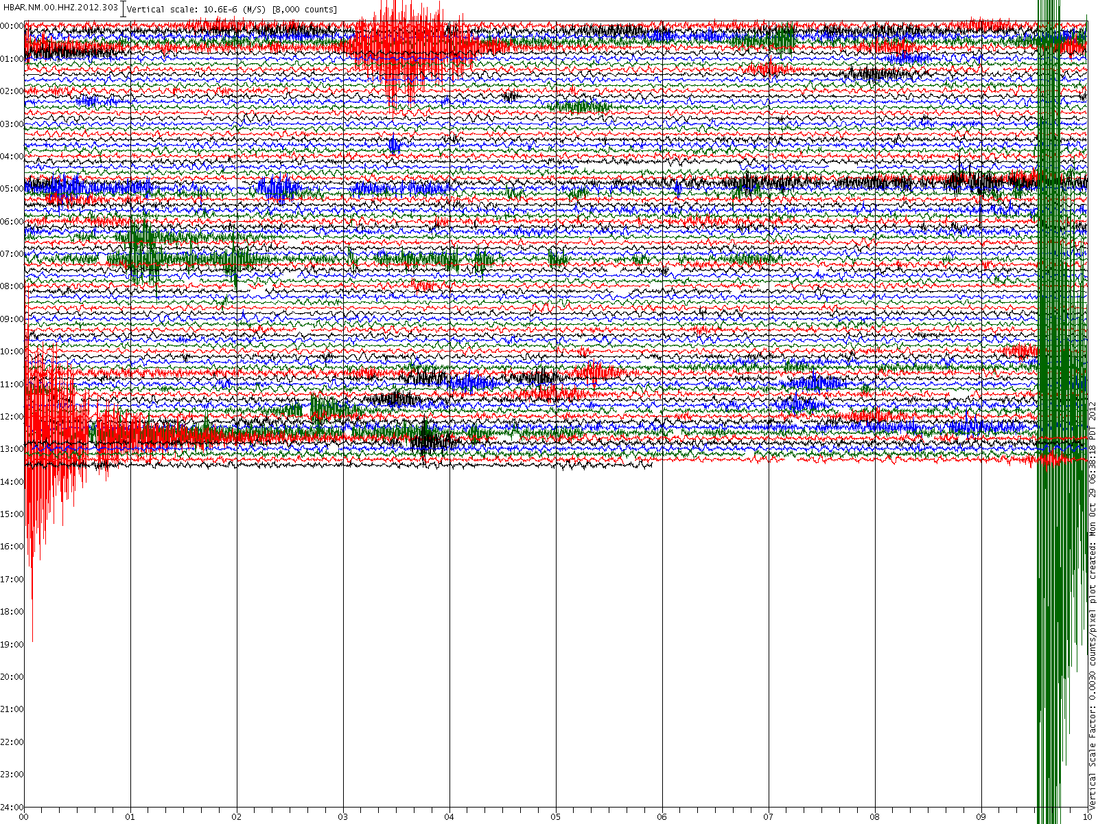
So far tracked it across to here HBAR.NM.00.HHZ.2012.303 and still getting bigger traces. That one is close to Memphis airport.
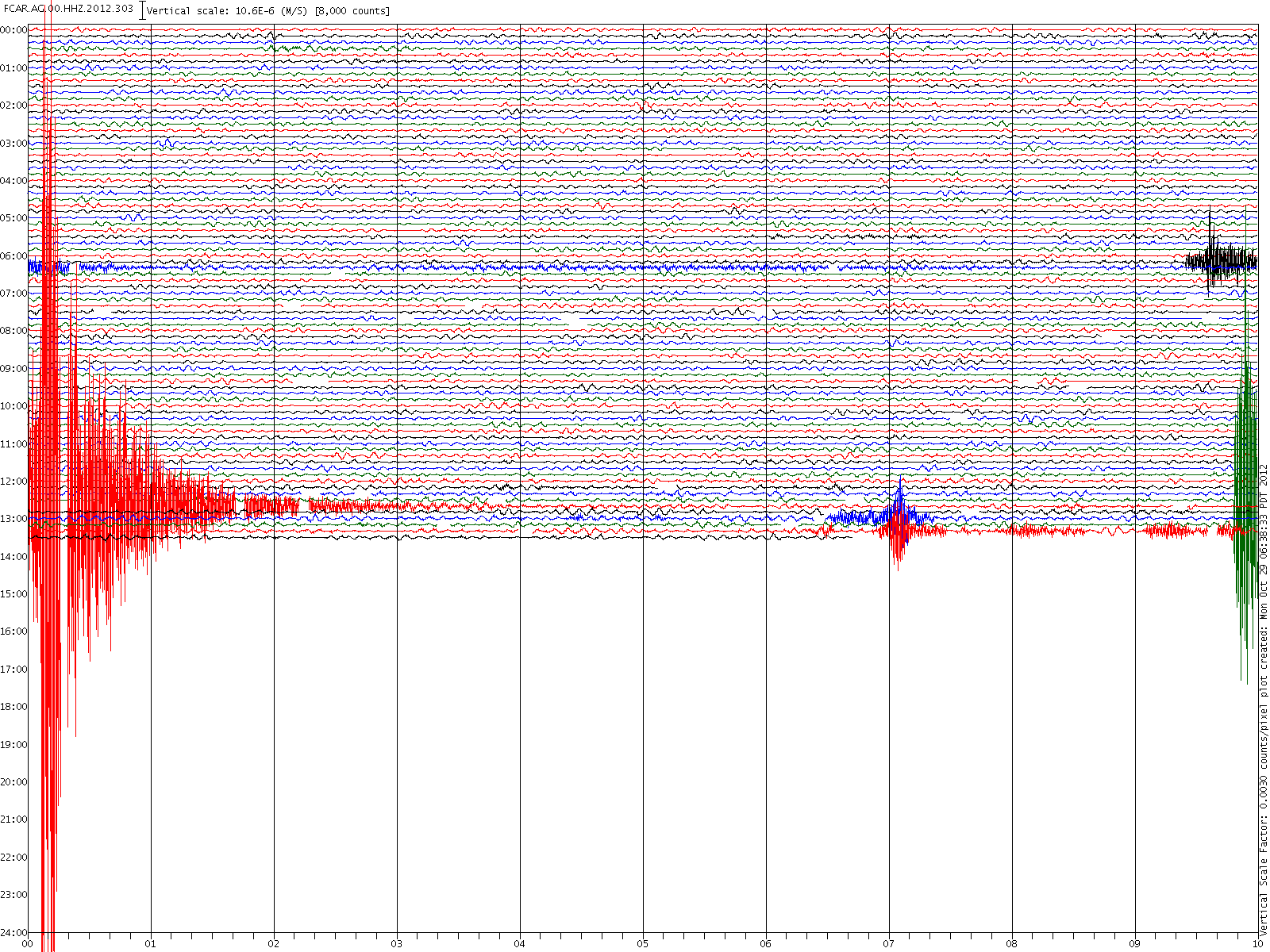
Massive trace on Ozark Folk Center: FCAR.AG.00.HHZ.2012.303
Here you are - Mag 3.9 ARKANSAS. I thought it might be.
www.emsc-csem.org...
And now USGS
Locati on in Google Maps
Derived from Event Data Source: USGS
Powered by QVSData
I love playing with the seismograms!
Those two look as if they are about the same but here the are at exactly the same 'scale' and you can see that the quake was closer to HBAR than FCAR (Ozark). By the way these are 1200 x 1600 images of the seismo. Not blown up, created at that size. (I have pushed these up to 1600 x 2000 so far but I am not sure how much bigger they can go)
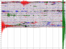
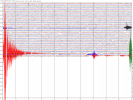
It starts about 15 seconds later at FCAR which is easy to see on these large scale images.
So far tracked it across to here HBAR.NM.00.HHZ.2012.303 and still getting bigger traces. That one is close to Memphis airport.
Massive trace on Ozark Folk Center: FCAR.AG.00.HHZ.2012.303
edit on 29/10/2012 by PuterMan because: (no reason given)
Here you are - Mag 3.9 ARKANSAS. I thought it might be.
www.emsc-csem.org...
And now USGS
Magnitude 3.9 - Arkansas
Locati on in Google Maps
- Date-Time: Monday, October 29, 2012 @ 12:39:22 UTC
- Earthquake location: 35.213°N, 90.652°W,
- Earthquake depth: 5.1 km
- Distances:
9km (5mi) SW of Parkin, Arkansas
26km (16mi) NNE of Forrest City, Arkansas
41km (25mi) W of Marion, Arkansas
43km (26mi) W of West Memphis, Arkansas
158km (98mi) ENE of Little Rock, Arkansas
- Event ID: usb000dgim
Derived from Event Data Source: USGS
Powered by QVSData
I love playing with the seismograms!
Those two look as if they are about the same but here the are at exactly the same 'scale' and you can see that the quake was closer to HBAR than FCAR (Ozark). By the way these are 1200 x 1600 images of the seismo. Not blown up, created at that size. (I have pushed these up to 1600 x 2000 so far but I am not sure how much bigger they can go)
It starts about 15 seconds later at FCAR which is easy to see on these large scale images.
edit on 29/10/2012 by PuterMan because: (no reason
given)
new topics
-
Former NYT Reporter Attacks Scientists For Misleading Him Over COVID Lab-Leak Theory
Education and Media: 1 hours ago -
Why did Phizer team with nanobot maker
Medical Issues & Conspiracies: 1 hours ago -
Pro Hamas protesters at Columbia claim hit with chemical spray
World War Three: 1 hours ago -
Elites disapearing
Political Conspiracies: 3 hours ago -
A Personal Cigar UFO/UAP Video footage I have held onto and will release it here and now.
Aliens and UFOs: 3 hours ago -
Go Woke, Go Broke--Forbes Confirms Disney Has Lost Money On Star Wars
Movies: 5 hours ago -
Freddie Mercury
Paranormal Studies: 6 hours ago -
Nirvana - Immigrant Song
Music: 10 hours ago -
British TV Presenter Refuses To Use Guest's Preferred Pronouns
Education and Media: 11 hours ago
top topics
-
British TV Presenter Refuses To Use Guest's Preferred Pronouns
Education and Media: 11 hours ago, 16 flags -
Go Woke, Go Broke--Forbes Confirms Disney Has Lost Money On Star Wars
Movies: 5 hours ago, 12 flags -
Pro Hamas protesters at Columbia claim hit with chemical spray
World War Three: 1 hours ago, 9 flags -
Trump To Hold Dinner with President of Poland At Trump Tower Tonight
2024 Elections: 14 hours ago, 8 flags -
Tucker Carlson interviews Christian pastor from Bethlehem.
Middle East Issues: 13 hours ago, 7 flags -
Elites disapearing
Political Conspiracies: 3 hours ago, 7 flags -
A family from Kansas with six children moved to the Moscow region
Other Current Events: 17 hours ago, 6 flags -
Freddie Mercury
Paranormal Studies: 6 hours ago, 6 flags -
A Personal Cigar UFO/UAP Video footage I have held onto and will release it here and now.
Aliens and UFOs: 3 hours ago, 5 flags -
Nirvana - Immigrant Song
Music: 10 hours ago, 4 flags
active topics
-
Max Loughan Boy Genius Or Something More?
Science & Technology • 67 • : fluctz -
British TV Presenter Refuses To Use Guest's Preferred Pronouns
Education and Media • 47 • : ImagoDei -
Trump To Hold Dinner with President of Poland At Trump Tower Tonight
2024 Elections • 36 • : ImagoDei -
Elites disapearing
Political Conspiracies • 14 • : AwakeNotWoke -
Freddie Mercury
Paranormal Studies • 1 • : AwakeNotWoke -
Why did Phizer team with nanobot maker
Medical Issues & Conspiracies • 1 • : AwakeNotWoke -
Pro Hamas protesters at Columbia claim hit with chemical spray
World War Three • 6 • : DBCowboy -
Former NYT Reporter Attacks Scientists For Misleading Him Over COVID Lab-Leak Theory
Education and Media • 1 • : Dandandat3 -
Gold and silver prices....woo hoo
History • 75 • : SchrodingersRat -
-@TH3WH17ERABB17- -Q- ---TIME TO SHOW THE WORLD--- -Part- --44--
Dissecting Disinformation • 512 • : cherokeetroy