It looks like you're using an Ad Blocker.
Please white-list or disable AboveTopSecret.com in your ad-blocking tool.
Thank you.
Some features of ATS will be disabled while you continue to use an ad-blocker.

Quake Watch 2012
page: 235share:
reply to post by wasobservingquietly
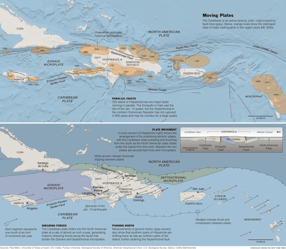
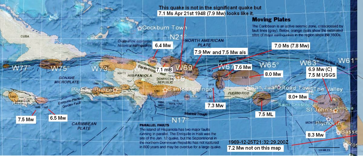
I thought it would be an interesting exercise to work out the magnitudes. Four and a half hours later I am not even half way through and have to stop - and in addition have found many that are not even mentioned on that map.
Compare the few on the map with this Haiti quake publication
I have started and I shall finish some time, but not today! Forgive me therefore for posting a part done map - but at least it gives an idea of the sort of magnitudes they are including.
I had always intended to look more closely at this area so thanks for kick-starting the project! (I think )
PS the map does not look the same as above because I have overlaid the lat/lon grid.
edit on 6/10/2012 by PuterMan because: (no reason given)
reply to post by PuterMan
hey Puterman i know ya said you were not done yet with that map but were the current swarm has been i didnt see a major eq located on that map. Has there been a major eq there in the past?
hey Puterman i know ya said you were not done yet with that map but were the current swarm has been i didnt see a major eq located on that map. Has there been a major eq there in the past?
PuterMan, this YouTube guy is showing the seismometers for Louisiana sinkhole area have been put off line. Do you have any idea why this would be
done? Anything to worry about?
edit on 6-10-2012 by Saucerwench because: x
reply to post by PuterMan
Thanks for picking up the ball & running with it!
Okay, maybe not running....
Or maybe running & then getting sidelined!!! Ha, ha!
I couldn't get the Haiti Quake Publication to open, it kept freezing my computer.
It said a drawing error has occurred.
Not enough memory left already???!!! I must clean house, er computer!
I was able to use the thumbnail though to at least see the magnitudes there.
So 6.4 to 8.3 range using the magnitudes as listed.
I'll be interested to see what else you find!
WOQ
reply to post by wujotvowujotvowujotvo
Thanks for posting the maps from that link.
That's going to be one of my New year's resolutions.....
to learn how to do some of those things.
Especially emoticons!
WOQ
Hey, it worked this time!!! I did it all by myself!!!
Thanks for posting the maps from that link.
That's going to be one of my New year's resolutions.....
to learn how to do some of those things.
Especially emoticons!
WOQ
Hey, it worked this time!!! I did it all by myself!!!
edit on 6-10-2012 by wasobservingquietly because: (no reason given)
5.3 earthquake, 6km ESE of Basqal, Azerbaijan. Oct 7 16:42 at epicenter (depth 41km).
2012-10-07 11:42:50 UTC
2012-10-07 16:42:50 UTC+05:00 at epicenter
2012-10-07 07:42:50 UTC-04:00 system time
Location
40.737°N 48.470°E depth=40.9km (25.4mi)
Nearby Cities
6km (4mi) ESE of Basqal, Azerbaijan
18km (11mi) NW of Shamakhi, Azerbaijan
19km (12mi) NNE of Aghsu, Azerbaijan
26km (16mi) E of Ismayilli, Azerbaijan
126km (78mi) WNW of Baku, Azerbaijan
How can we stop frackquakes ?
At the time of the Arkansas swarm, Susan and her neighbours should take the matter to court.
Sue the frackers.
www.ohio.com...
What's the Dakotas got to do with Texas?
Well, the Dakotas are a lot like Texas. Both have increasing rates of earthquakes and they love to drill wells.
www.duluthnewstribune.com...
www.huffingtonpost.com...
www.wday.com...
Here's something to read.
news.co.cr...
More reading...
www.nwpr.org...
I was going to say something about Louisiana but Puterman pretty much summed it up. It looks like they'll be storing gas in all kinds of interesting places. The gas boys are keen on finding new ways to create unintended consequences and cause natural disasters.
Just for own sake due to obsessive watching, I'm thinking rain in China and/or Asia may increase, as do the rains...(raining harder=dirtier air)
english.eastday.com...
edit on 7-10-2012 by ericblair4891 because: (no reason given)
M5.8 - 103km NE of Calama, Chile 2012-10-08 01:50:25 UTC
earthquake.usgs.gov...
A little shake up to post.
edit on 7-10-2012 by timetothink because: (no reason given)
5.8 earthquake, 103km NE of Calama, Chile. Oct 7 22:50 at epicenter (depth 115km).
2012-10-08 01:50:25 UTC
2012-10-07 22:50:25 UTC-03:00 at epicenter
2012-10-07 21:50:25 UTC-04:00 system time
Location
21.769°S 68.262°W depth=115.3km (71.7mi)
Nearby Cities
103km (64mi) NE of Calama, Chile
203km (126mi) E of Tocopilla, Chile
208km (129mi) SW of Uyuni, Bolivia
213km (132mi) SW of Colchani, Bolivia
583km (362mi) S of La Paz, Bolivia
Earthquake Details
This event has been reviewed by a seismologist.
Magnitude
6.0
Date-Time
Monday, October 08, 2012 at 06:26:22 UTC
Monday, October 08, 2012 at 12:26:22 AM at epicenter
Location
25.182°N, 109.622°W
Depth
10.1 km (6.3 miles)
Region
GULF OF CALIFORNIA
Distances
93 km (58 miles) SSW (209°) from Ahome, Sinaloa, Mexico
93 km (58 miles) SW (225°) from Los Mochis, Sinaloa, Mexico
102 km (63 miles) SW (232°) from Juan José Ríos, Sinaloa, Mexico
1089 km (676 miles) SE (137°) from Tijuana, Baja California, Mexico
Location Uncertainty
horizontal +/- 17.8 km (11.1 miles); depth +/- 4.2 km (2.6 miles)
Parameters
NST=535, Nph=535, Dmin=440.8 km, Rmss=1 sec, Gp=122°,
M-type=regional moment magnitude (Mw), Version=B
Source
Magnitude: USGS NEIC (WDCS-D)
Location: USGS NEIC (WDCS-D)
Event ID
usc000d3ne
reply to post by Saucerwench
Unfortunately people who make these sort of YT videos have little knowledge. To assume that the seismometers have 'been taken off line' is jumping to conclusions as the inference is that it was done intentionally. I do not believe that to be that case.
This trace shows something happened LA01.GS.00.BHZ.2012.279
The seismo is now back on line: LA01.GS.00.BHZ.2012.282
It got sick and someone made it better. It just took a bit of time and it came back on the 7th: LA01.GS.00.BHZ.2012.281
In the meantime LA09 was functional: LA09.GS.00.BHZ.2012.281 for the 7th, LA09.GS.00.BHZ.2012.281 for the 6th and LA09.GS.00.BHZ.2012.279 for the 5th which interestingly also shows some sort of problem but the instrument survived the trauma, took an aspirin and carried on. LA02 was also OK. I have not checked the others.
There are 6 (I think) seismos there yet this YT jockey singles out ONE and infers there is no coverage. I won't print what I think of people like that!
By the way since we are discussing the sinkhole this may be of interest.
Gas trapped near sinkhole
edit on 8/10/2012 by PuterMan because: (no reason given)
Banda Sea Mag 6.4 EMSC
www.emsc-csem.org...
More details in a mo.
Locat ion in Google Maps
Derived from Event Data Source: USGS
Powered by QVSData
EMSC also down to 6.3
Geofon also have 6.3 - manually revised.
and an aftershock
www.emsc-csem.org...
www.emsc-csem.org...
More details in a mo.
Magnitude 6.3 - Banda Sea
Locat ion in Google Maps
- Date-Time: Monday, October 08, 2012 @ 11:43:35 UTC
- Earthquake location: 4.442°S, 129.165°E,
- Earthquake depth: 34.7 km
- Distances:
112km (69mi) SSE of Saparua, Indonesia
125km (77mi) SSE of Amahai, Indonesia
136km (84mi) SE of Ambon, Indonesia
419km (260mi) WNW of Tual, Indonesia
604km (375mi) NE of Dili, East Timor
- Event ID: usc000d3rv
Derived from Event Data Source: USGS
Powered by QVSData
EMSC also down to 6.3
Geofon also have 6.3 - manually revised.
and an aftershock
www.emsc-csem.org...
edit on 8/10/2012 by PuterMan because: (no reason given)
reply to post by ericblair4891
A lot of good wilfing in your links!
I didn't know this about the fracking video:
The Fracking Song
By Bob Downing Published: December 23, 2011
On Dec. 7, Time magazine named "My Water's On Fire Tonight (The Fracking Song)" one of its Top 10 most-creative videos of 2011.
The 2-minute, 33-second video was creative by a team of New York University students at Studio 20 NYU.
www.ohio.com...
Another fracking animation video:
www.ohio.com...
Isn't working for some reason. It's after the first video.
Love this one. Two frack feuding grannies!!!
www.ohio.com...
New movie on fracking due out in December
The trailers are out for for Gus Van Sant’s dramatic movie Promised Land.
The film stars Matt Damon and Frances McDormand as an oil company sales team sent in to snap up oil leases in a dying farm town.
It’s been slated to open in limited release on Dec. 28.
The script was written by Damon and John Krasinki (NBC’s The Office), who co-stars as a community activist.
Van Sant directed Damon in Good Will Hunting.
www.ohio.com...
Hey, did you see the picture & audio interview of John Vidale in your link?
Click on top right to get second picture. Silent Earthquakes Ripple Under Cascadia:
www.nwpr.org...
I was lost in there for quite awhile. Good stuff!!!
WOQ
edit on 8-10-2012 by wasobservingquietly because: (no reason given)
Originally posted by wasobservingquietly
Found the trailer for 'Promised Land':
www.imdb.com...
Looks like it should be good.
WOQ
Anybody here familiar with`the 70's tv soap Dallas? Well it's back on channel 5 here in the UK...and guess what..Bobby Ewings son Christopher is all growed up and trying to 'invent' a new way to get at gas without causing eq's!!!! Will be interesting to see where they go with this storyline.
OK, I'll go get my first brew of the day now.
Rainbows
Jane
Magnitude Mw 6.4
Region BALLENY ISLANDS REGION
Date time 2012-10-09 12:32:04.0 UTC
Location 61.03 S ; 153.96 E
Depth 10 km
Distances 2657 km S Melbourne (pop 3,730,206 ; local time 22:32:04.4 2012-10-09)
1996 km SW Dunedin (pop 114,347 ; local time 01:32:04.4 2012-10-10)
1873 km SW Invercargill (pop 47,287 ; local time 01:32:04.4 2012-10-10)
EMSC
Originally posted by Hellas
Magnitude Mw 6.4
Region BALLENY ISLANDS REGION
Date time 2012-10-09 12:32:04.0 UTC
Location 61.03 S ; 153.96 E
Depth 10 km
Distances 2657 km S Melbourne (pop 3,730,206 ; local time 22:32:04.4 2012-10-09)
1996 km SW Dunedin (pop 114,347 ; local time 01:32:04.4 2012-10-10)
1873 km SW Invercargill (pop 47,287 ; local time 01:32:04.4 2012-10-10)
EMSC
UPDATE
Magnitude mb 5.5
Region BALLENY ISLANDS REGION
Date time 2012-10-09 12:32:03.0 UTC
Location 61.21 S ; 153.78 E
Depth 8 km
Distances 2673 km S Melbourne (pop 3,730,206 ; local time 22:32:03.5 2012-10-09)
2017 km SW Dunedin (pop 114,347 ; local time 01:32:03.5 2012-10-10)
1894 km SW Invercargill (pop 47,287 ; local time 01:32:03.5 2012-10-10)
reply to post by Hellas
Curious that. First they say 6.4 Mw, now they say 5.6 mb which is way under a mag 6 Mw let alone a 6.4.
USGS still sticking at 6.4 for the time being.
Update on that. EMSC and USGS not changed positions yet.
Potsdam have just come in with a manually revised Mag 6.6 Mw
SCARDEC also have Mag 6.6 Mw
Something definitely wrong with the EMSC revision down to 5.6 mb
edit on 9/10/2012 by PuterMan because: (no reason given)
reply to post by PuterMan
aaand back up again
www.emsc-csem.org...
aaand back up again
Magnitude Mw 6.4
Region BALLENY ISLANDS REGION
Date time 2012-10-09 12:32:02.0 UTC
Location 61.11 S ; 154.15 E
Depth 2 km
Distances 2669 km S Melbourne (pop 3,730,206 ; local time 22:32:02.2 2012-10-09)
1996 km SW Dunedin (pop 114,347 ; local time 01:32:02.2 2012-10-10)
1874 km SW Invercargill (pop 47,287 ; local time 01:32:02.2 2012-10-10)
www.emsc-csem.org...
new topics
-
WF Killer Patents & Secret Science Vol. 1 | Free Energy & Anti-Gravity Cover-Ups
General Conspiracies: 1 minutes ago -
Hurt my hip; should I go see a Doctor
General Chit Chat: 50 minutes ago -
Israel attacking Iran again.
Middle East Issues: 1 hours ago -
Michigan school district cancels lesson on gender identity and pronouns after backlash
Education and Media: 2 hours ago -
When an Angel gets his or her wings
Religion, Faith, And Theology: 2 hours ago -
Comparing the theology of Paul and Hebrews
Religion, Faith, And Theology: 3 hours ago -
Pentagon acknowledges secret UFO project, the Kona Blue program | Vargas Reports
Aliens and UFOs: 4 hours ago -
Boston Dynamics say Farewell to Atlas
Science & Technology: 4 hours ago -
I hate dreaming
Rant: 5 hours ago -
Man sets himself on fire outside Donald Trump trial
Mainstream News: 7 hours ago
top topics
-
The Democrats Take Control the House - Look what happened while you were sleeping
US Political Madness: 8 hours ago, 18 flags -
In an Historic First, In N Out Burger Permanently Closes a Location
Mainstream News: 10 hours ago, 16 flags -
A man of the people
Medical Issues & Conspiracies: 15 hours ago, 11 flags -
Biden says little kids flip him the bird all the time.
Politicians & People: 7 hours ago, 8 flags -
Man sets himself on fire outside Donald Trump trial
Mainstream News: 7 hours ago, 7 flags -
Pentagon acknowledges secret UFO project, the Kona Blue program | Vargas Reports
Aliens and UFOs: 4 hours ago, 6 flags -
Israel attacking Iran again.
Middle East Issues: 1 hours ago, 5 flags -
Michigan school district cancels lesson on gender identity and pronouns after backlash
Education and Media: 2 hours ago, 4 flags -
4 plans of US elites to defeat Russia
New World Order: 17 hours ago, 4 flags -
Boston Dynamics say Farewell to Atlas
Science & Technology: 4 hours ago, 4 flags
active topics
-
WF Killer Patents & Secret Science Vol. 1 | Free Energy & Anti-Gravity Cover-Ups
General Conspiracies • 0 • : 727Sky -
Boston Dynamics say Farewell to Atlas
Science & Technology • 5 • : Caver78 -
Hurt my hip; should I go see a Doctor
General Chit Chat • 7 • : randomtangentsrme -
Biden says little kids flip him the bird all the time.
Politicians & People • 16 • : stelth2 -
When an Angel gets his or her wings
Religion, Faith, And Theology • 2 • : stelth2 -
MULTIPLE SKYMASTER MESSAGES GOING OUT
World War Three • 51 • : Zaphod58 -
Israel attacking Iran again.
Middle East Issues • 19 • : stelth2 -
Pentagon acknowledges secret UFO project, the Kona Blue program | Vargas Reports
Aliens and UFOs • 7 • : Ophiuchus1 -
-@TH3WH17ERABB17- -Q- ---TIME TO SHOW THE WORLD--- -Part- --44--
Dissecting Disinformation • 549 • : cherokeetroy -
In an Historic First, In N Out Burger Permanently Closes a Location
Mainstream News • 9 • : VariedcodeSole