It looks like you're using an Ad Blocker.
Please white-list or disable AboveTopSecret.com in your ad-blocking tool.
Thank you.
Some features of ATS will be disabled while you continue to use an ad-blocker.

Quake Watch 2012
page: 217share:
reply to post by muzzy
From the IRIS Education and Outreach PDF file on how earthquakes are located we get
Google has recently started obfuscating their links to pdf files with masses of irrelevant information, presumably concerned with the gathering of intel, and making it impossible to copy a proper link to pass on, however the link in green below their rubbish should work. - www.mgs.md.gov...
Another broken down step by step version of this can be found here
Note that they are in effect quoting 10 km/sec as the interval speed on the assumption that these waves always travel at the same speed. They do not. That is a major simplification. The further away from the event the more likely you are to get attenuation of the signal and damping of the speed. In addition to this not all strata in the earth pass the signal at the same speed and indeed the signals going through the earth centre change considerably.
In order to illustrate what I am saying download and have a read of this article which contains this abstract: (I have removed all Googles rubbish from that link so hope it works)
This article on Earthquake Location Accuracy (Google rubbish removed) says in it's abstract
It is also a good read. (30 pages) Page 28 however contains the answer to your dilema Muzzy.
Sorry - run out of space. See next post
From the IRIS Education and Outreach PDF file on how earthquakes are located we get
From observing and analyzing many earthquakes, we know the relationship between the S-P time and the distance between the station and the earthquake. We can therefore convert each measured S-P time to
distance. A time interval of 1.5 minutes corresponds to a distance of 900 kilometers, 3 minutes to 1800 kilometers, and 5 minutes to 3300 kilometers.
Google has recently started obfuscating their links to pdf files with masses of irrelevant information, presumably concerned with the gathering of intel, and making it impossible to copy a proper link to pass on, however the link in green below their rubbish should work. - www.mgs.md.gov...
Another broken down step by step version of this can be found here
Note that they are in effect quoting 10 km/sec as the interval speed on the assumption that these waves always travel at the same speed. They do not. That is a major simplification. The further away from the event the more likely you are to get attenuation of the signal and damping of the speed. In addition to this not all strata in the earth pass the signal at the same speed and indeed the signals going through the earth centre change considerably.
In order to illustrate what I am saying download and have a read of this article which contains this abstract: (I have removed all Googles rubbish from that link so hope it works)
The hypocenters of 43 earthquakes on Kilauea Volcano were analyzed in detail in order to examine the accuracy of hypocenters determined with data from tripartite arrays and to look for evidence of zones of abnormally high or low velocity in a region of complex crustal structure. Ten vertical and two horizontal seismometers were operated on the south flank of Kilauea within the seismic network of the Hawaiian Volcano Observatory. A number of combinations of the temporary stations were treated as separate tripartite arrays. The sides of each tripartite array were 1 to 2 km long. Azimuths and apparent velocities of P-wave fronts observed at these arrays generally agreed well with the values predicted from hypocenters calculated using data from as many as 20 stations. Some observed azimuths differed from the predicted values by over 40° and some apparent velocities differed by nearly a factor of 2. These differences are consistent with the travel-time residuals found when the hypocenters are located with all available data. They can be attributed to local zones of abnormally high or low velocity or to changes in the thicknesses of the assumed crustal layers. Waves that travel through the east and southwest rift zones arrive relatively early and the waves traveling through the Kaoiki fault zone arrive late. Refraction data were compiled to obtain a new average crustal structure. When small tripartite arrays are used to locate shallow earthquakes, a crustal structure with a linear increase in velocity should be assumed in order to calculate unique hypocenters and to obtain less scatter in a group of hypocenters.
This article on Earthquake Location Accuracy (Google rubbish removed) says in it's abstract
Abstract Earthquake location catalogs are not an exact representation of the true earthquake locations. They contain random error, for example from errors in the arrival time picks, as well as systematic biases. The most important source of systematic errors in earthquake locations is the inherent dependence of earthquake locations on the assumed seismic velocity structure of the Earth. Random errors may be accounted for in formal uncertainty estimates, but systematic biases are not, and they must be considered based on knowledge about how the earthquakes were located. In this article we discuss earthquake location methods and methods for estimating formal uncertainties; we consider systematic biases in earthquake location catalogs; and we give readers guidance on how to identify good-quality earthquake locations.
It is also a good read. (30 pages) Page 28 however contains the answer to your dilema Muzzy.
Sorry - run out of space. See next post
Global centroid catalogs are also sometimes used in statistical studies. The earthquake centroid, the center of moment, is often offset rom the hypocenter by several 10s of km or more, so the locations from the centroid catalogs are not directly comparable to hypocenter location catalogs. It is important to choose the catalog appropriate for the scientific question at hand: if one is interested in where earthquakes nucleate, a hypocenter catalog is preferable; while if one is interested in where the most slip occurs, a centroid catalog is more appropriate. The location uncertainty of centroid catalogs is similar to that of other global location catalogs.
reply to post by Doodle19815
I took a look but don't think it worth getting involved. Not impressed by her description of herself.
3 hours? By boat, train, plane, pony express, shank's pony, as the crow flies?
If we consider an average of 30 mph or 48 kph then 3 hour would be 144 km or ~14 seconds for the waves. @2 hours only 96 km or ~9 seconds. Depending on the geology of the area it is indeed possible for her to have felt a 2.6. But moved the couch? Not so sure about that.
The other problem is that the time of the earthquake suggested was Monday, September 03, 2012 at 07:12:32 AM at epicenter so not exactly late at night on Saturday.
I was sitting on my duff Saturday night
Hi PM,
U being one of the most LEVEL HEADED ones around here, I wonder whether you concur with some or all of the following?
U being one of the most LEVEL HEADED ones around here, I wonder whether you concur with some or all of the following?
There are now five regions of the world where seismic tension is registering higher than normal: California, the Virgin Islands of the Caribbean plate, Alaska, the Philippines, and Indonesia. Any of these regions are primed for the eruption of large-scale seismic events. People in high-risk seismic zones should remain alert for the potential occurrence of potentially hazardous seismic or volcanic episodes./ex]edit on 5-9-2012 by SpaceJockey1 because: Oops spelling
Earthquake Details
This event has been reviewed by a seismologist.
Magnitude
7.6
Date-Time
Wednesday, September 05, 2012 at 14:42:10 UTC
Wednesday, September 05, 2012 at 08:42:10 AM at epicenter
Location
10.120°N, 85.347°W
Depth
40.8 km (25.4 miles)
Region
COSTA RICA
Distances
60 km (38 miles) SSE (167°) from Liberia, Costa Rica
127 km (79 miles) SSW (209°) from San Carlos, Nicaragua
141 km (88 miles) W (276°) from SAN JOSE, Costa Rica
Location Uncertainty
horizontal +/- 13.6 km (8.5 miles); depth +/- 6.2 km (3.9 miles)
Parameters
NST=737, Nph=737, Dmin=135.8 km, Rmss=1.42 sec, Gp= 18°,
M-type=(unknown type), Version=F
Source
Magnitude: USGS NEIC (WDCS-D)
Location: USGS NEIC (WDCS-D)
Event ID
usc000cfsd
USGS
edit on 5-9-2012 by lurksoften because: (no reason
given)
Just saw that... not even 5 minutes before I was looking at the real time quake map. Stepped away to get some breakfast and boom. This is tragic.
Praying for all those in the area. Please no tsunami....
reply to post by SpaceJockey1
Can you give us the source for this? Thanks.
My heart goes out to all people in the affected area.
Can you give us the source for this? Thanks.
My heart goes out to all people in the affected area.
It looks like this earthquake was originally reported offshore and a bit deeper. Now USGS
shows the epicenter on land and only 20km deep.
So, we shouldn't expect a tsunami, but the shaking was potentially life-threatening.
Still waiting on Pager info...
reply to post by PuterMan
Thank you Puterman--bookmarked the direct last-page link.
So, we shouldn't expect a tsunami, but the shaking was potentially life-threatening.
Still waiting on Pager info...
reply to post by PuterMan
Thank you Puterman--bookmarked the direct last-page link.
Tsunami from this quake in Costa Rica not likely, quake is about 8km inland from sea shore. Very shallow and only 8 km from the very beautiful
Samara. Depends on the movement directions, this could have caused some severe damage and possibly life lost. Fortunately not high population
(Include tourist probbaly around 10,000) neither high buildings. At this early morning time, most people would be up and around as well.
edit on 5/9/2012 by Aromaz because: (no reason given)
000
WEHW42 PHEB 051451
TIBHWX
HIZ001>003-005>009-012>014-016>021-023>026-051651-
TSUNAMI INFORMATION STATEMENT NUMBER 1
NWS PACIFIC TSUNAMI WARNING CENTER EWA BEACH HI
451 AM HST WED SEP 05 2012
TO - CIVIL DEFENSE IN THE STATE OF HAWAII
SUBJECT - TSUNAMI INFORMATION STATEMENT
THIS STATEMENT IS FOR INFORMATION ONLY. NO ACTION REQUIRED.
AN EARTHQUAKE HAS OCCURRED WITH THESE PRELIMINARY PARAMETERS
ORIGIN TIME - 0442 AM HST 05 SEP 2012
COORDINATES - 9.9 NORTH 85.5 WEST
LOCATION - OFF COAST OF COSTA RICA
MAGNITUDE - 7.9 MOMENT
EVALUATION
THE PACIFIC TSUNAMI WARNING CENTER HAS ISSUED AN EXPANDING
REGIONAL TSUNAMI WARNING AND WATCH FOR PARTS OF THE PACIFIC
LOCATED CLOSER TO THE EARTHQUAKE. AN EVALUATION OF THE PACIFIC
WIDE TSUNAMI THREAT IS UNDERWAY AND THERE IS A POSSIBILITY THAT
HAWAII COULD BE ELEVATED TO A WATCH OR WARNING STATUS.
IF TSUNAMI WAVES IMPACT HAWAII THEIR ESTIMATED EARLIEST ARRIVAL
TIME IS
0243 PM HST WED 05 SEP 2012
THIS WILL BE THE ONLY STATEMENT ISSUED FOR THIS EVENT UNLESS
ADDITIONAL DATA ARE RECEIVED.
Source
Revised magnitude, location, and depth again.
REVIEWED
Event ID
usc000cfsd
Data pulled from USGS technical page.
ETA:
Pager info now posted.
Thankfully the magnitude has come down and the estimated population exposed to the highest intensity shaking is relatively low (32k).
Preferred Location Parameters
Magnitude
7.6 Mww
Location
10.120°N, 85.347°W
± 13.6 km
Depth
40.8 km
± 6.2 km
REVIEWED
Event ID
usc000cfsd
Data pulled from USGS technical page.
ETA:
Pager info now posted.
Thankfully the magnitude has come down and the estimated population exposed to the highest intensity shaking is relatively low (32k).
edit on
9/5/2012 by Olivine because: (no reason given)
Hmmm... quite near the opposite point on Earth from the previous 7+ quake in Phllippines.
All my family is there. Phones were down but I was able to contact a cousin via FB chat. She is near the capital and she said it was felt very
strong there. I finally saw a post from my mother on FB so I think both her and my dad are fine. I'm waiting to see what the damage was though!
reply to post by Aromaz
Opposite and just as strong at the end of geomagnetic storm. Large sunspot growing at incredible speed. Connection?
Opposite and just as strong at the end of geomagnetic storm. Large sunspot growing at incredible speed. Connection?
reply to post by favouriteslave
You were the first person I thought about when I opened the comp and saw the news. Take good care and know my prayers are with your family.
You were the first person I thought about when I opened the comp and saw the news. Take good care and know my prayers are with your family.
reply to post by SpaceJockey1
Only just come back in to find this one. I guess as far as your comment goes it depends who was the source. I am not sure that I would agree with all of those areas.
California, - no the current activity is cyclical and normal
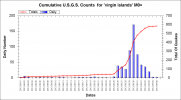
the Virgin Islands of the Caribbean plate, - so there is/was a small swarm. Not particularly significant. Vanuatu will kick off before that area. See the Virgins....
Alaska, - may be volcanic therefore not relevant
the Philippines, - well it was but that rather unusual Mag 7 may have cured that for a while
and Indonesia. - and always Indonesia. Where is the additional activity over and above the normal? I won't put up a chart for that as 'Indonesia' does not define the area properly, but when I do put in Indonesia for this year guess what? I get the normal straight line. There happens to have been a slight increase yesterday, but it doe not affect the graph.
And what is normal? Normal now, normal in the 1980s, normal in the 13th century, normal in 20,000 BCE - oh right, of course normal as defined the the extremely short term collective Internet memory. Pssssssh!
Bit like the stock market - the share prices are rising, the share prices are falling all for the sake of a few points of an hour or two. Look at the bigger picture, the longer history. One day of a slight increase does not an increase in seismicity make.
I see GFZ Potsdam have the Costa Rica as 7.4.
Only just come back in to find this one. I guess as far as your comment goes it depends who was the source. I am not sure that I would agree with all of those areas.
There are now five regions of the world where seismic tension is registering higher than normal:
California, - no the current activity is cyclical and normal
the Virgin Islands of the Caribbean plate, - so there is/was a small swarm. Not particularly significant. Vanuatu will kick off before that area. See the Virgins....
Alaska, - may be volcanic therefore not relevant
the Philippines, - well it was but that rather unusual Mag 7 may have cured that for a while
and Indonesia. - and always Indonesia. Where is the additional activity over and above the normal? I won't put up a chart for that as 'Indonesia' does not define the area properly, but when I do put in Indonesia for this year guess what? I get the normal straight line. There happens to have been a slight increase yesterday, but it doe not affect the graph.
And what is normal? Normal now, normal in the 1980s, normal in the 13th century, normal in 20,000 BCE - oh right, of course normal as defined the the extremely short term collective Internet memory. Pssssssh!
Bit like the stock market - the share prices are rising, the share prices are falling all for the sake of a few points of an hour or two. Look at the bigger picture, the longer history. One day of a slight increase does not an increase in seismicity make.
I see GFZ Potsdam have the Costa Rica as 7.4.
edit on 5/9/2012 by PuterMan because: Ah, the inevitable speeling erra
Okay so everyone is fine as far as I know. I talked to my cousin via FB and she said it was felt strongly there and finally a post from my mother and
a call from my father. He described it from the second floor of their house as a "fun ride" But if you have ever been there you know most housing is
built to withstand earthquakes of this size! So far all my family is ok but my cousin took pics of a road in Alajuela that is impassable due to
Rock/landslide. My mom said this "Diana if you tried calling and couldn't get through its probably because your dad was on the phone talking to faily.
So far the phones are working within the country. The house was really swaying and a few things in the house were swinging back and forth. It seemed
like more than 40 seconds. It scared the crap out of the dog. There were after shocks in Cartago, but we didn't feel them here...Mom"
www.facebook.com...
and
www.facebook.com...
www.facebook.com...
and
www.facebook.com...
edit on 5-9-2012 by
favouriteslave because: added pic
reply to post by prophetboy12
There are currently no large sunspots. It is the internet memory thing again. What is currently on the Sun is extremely small especially since we are so close to Solar Max. Here is a big one There is currently nothing anything like that. (And here is another)
I have been keeping the records for sunspots and earthquakes for some time no a still cannot see a provable connection beyond circumstance. (Which does not mean I do not believe it, just that I can't prove it)
edit on 5/9/2012 by PuterMan because: To add more "stuff" 'cos "stuff" is good.
new topics
-
Comparing the theology of Paul and Hebrews
Religion, Faith, And Theology: 23 minutes ago -
Pentagon acknowledges secret UFO project, the Kona Blue program | Vargas Reports
Aliens and UFOs: 1 hours ago -
Boston Dynamics say Farewell to Atlas
Science & Technology: 1 hours ago -
I hate dreaming
Rant: 2 hours ago -
Man sets himself on fire outside Donald Trump trial
Mainstream News: 4 hours ago -
Biden says little kids flip him the bird all the time.
2024 Elections: 4 hours ago -
The Democrats Take Control the House - Look what happened while you were sleeping
US Political Madness: 4 hours ago -
Sheetz facing racial discrimination lawsuit for considering criminal history in hiring
Social Issues and Civil Unrest: 4 hours ago -
In an Historic First, In N Out Burger Permanently Closes a Location
Mainstream News: 6 hours ago -
MH370 Again....
Disaster Conspiracies: 7 hours ago
top topics
-
In an Historic First, In N Out Burger Permanently Closes a Location
Mainstream News: 6 hours ago, 14 flags -
The Democrats Take Control the House - Look what happened while you were sleeping
US Political Madness: 4 hours ago, 11 flags -
Thousands Of Young Ukrainian Men Trying To Flee The Country To Avoid Conscription And The War
Other Current Events: 17 hours ago, 8 flags -
A man of the people
Medical Issues & Conspiracies: 12 hours ago, 8 flags -
Man sets himself on fire outside Donald Trump trial
Mainstream News: 4 hours ago, 7 flags -
Biden says little kids flip him the bird all the time.
2024 Elections: 4 hours ago, 6 flags -
4 plans of US elites to defeat Russia
New World Order: 13 hours ago, 4 flags -
Pentagon acknowledges secret UFO project, the Kona Blue program | Vargas Reports
Aliens and UFOs: 1 hours ago, 4 flags -
Sheetz facing racial discrimination lawsuit for considering criminal history in hiring
Social Issues and Civil Unrest: 4 hours ago, 3 flags -
Are you ready for the return of Jesus Christ? Have you been cleansed by His blood?
Religion, Faith, And Theology: 9 hours ago, 3 flags
active topics
-
12 jurors selected in Trump criminal trial
US Political Madness • 109 • : ImagoDei -
Boston Dynamics say Farewell to Atlas
Science & Technology • 2 • : theatreboy -
The Democrats Take Control the House - Look what happened while you were sleeping
US Political Madness • 37 • : Mahogani -
The defamation of Mary Magdalene
Religion, Faith, And Theology • 15 • : Solvedit -
A man of the people
Medical Issues & Conspiracies • 9 • : tarantulabite1 -
Silent Moments --In Memory of Beloved Member TDDA
Short Stories • 47 • : Naftalin -
Thousands Of Young Ukrainian Men Trying To Flee The Country To Avoid Conscription And The War
Other Current Events • 38 • : DBCowboy -
George Knapp AMA on DI
Area 51 and other Facilities • 28 • : theshadowknows -
Pentagon acknowledges secret UFO project, the Kona Blue program | Vargas Reports
Aliens and UFOs • 4 • : Ophiuchus1 -
Comparing the theology of Paul and Hebrews
Religion, Faith, And Theology • 0 • : DISRAELI2