It looks like you're using an Ad Blocker.
Please white-list or disable AboveTopSecret.com in your ad-blocking tool.
Thank you.
Some features of ATS will be disabled while you continue to use an ad-blocker.

Quake Watch 2012
page: 215share:
Originally posted by this_is_who_we_are
reply to post by kennvideo
No.worries. I was just putting my 2 cents in. What are the chances of another big one in the same area any time soon? That may be a stupid question, but I just had to ask. I know little about earthquakes and plate tectonics and the like.
I talked to the guy from Brighthouse, my cable company, in the Philippines as I said above. They are all tuned to the TV and radio he said. I know that Brighthouse overnight is routed to theor Phil offices, so I figured I'd ask and post the results of our talk here. He's on the northern most island and these are occurring SE of his area, but they still feel them.
Saturday September 1 2012, 10:38:41 UTC 23 minutes ago offshore Atacama, Chile 5.0 39.3 USGS Feed
2012-09-01 10:38:41 UTC
2012-09-01 05:38:41 UTC-05:00 at epicenter
2012-09-01 06:38:41 UTC-04:00 system time
Nearby Cities
99km (62mi) W of Copiapo, Chile
156km (97mi) SW of Diego de Almagro, Chile
160km (99mi) NNW of Vallenar, Chile
217km (135mi) SSW of Taltal, Chile
695km (432mi) N of Santiago, Chile
edit on 1-9-2012 by kennvideo because: info
Saturday September 1 2012, 11:02:56 UTC 27 minutes ago Sulawesi, Indonesia 4.7 137.8USGS
2012-09-01 11:02:56 UTC
2012-09-01 19:02:56 UTC+08:00 at epicenter
2012-09-01 07:02:56 UTC-04:00 system time
Nearby Cities
50km (31mi) SSE of Bilungala, Indonesia
73km (45mi) SSE of Gorontalo, Indonesia
115km (71mi) NNE of Luwuk, Indonesia
227km (141mi) SW of Tomohon, Indonesia
971km (603mi) NNW of Dili, East Timo
Saturday September 1 2012, 10:57:34 UTC 32 minutes ago northern Yukon Territory, Canada 4.4 10.1 USGS
2012-09-01 10:57:34 UTC
2012-09-01 03:57:34 UTC-07:00 at epicenter
2012-09-01 06:57:34 UTC-04:00 system time
Nearby Cities
78km (48mi) SW of Fort McPherson, Canada
575km (357mi) ENE of Badger, Alaska
581km (361mi) ENE of Fairbanks, Alaska
583km (362mi) ENE of College, Alaska
688km (428mi) N of Whitehorse, Canada
Saturday September 1 2012, 11:55:30 UTC 22 minutes ago offshore El Salvador 4.6 35.2 USGS Feed
2012-09-01 11:55:30 UTC
2012-09-01 05:55:30 UTC-06:00 at epicenter
2012-09-01 07:55:30 UTC-04:00 system time
Nearby Cities
85km (53mi) SSW of Puerto El Triunfo, El Salvador
97km (60mi) SSW of Usulutan, El Salvador
102km (63mi) S of Zacatecoluca, El Salvador
105km (65mi) SSW of San Rafael Oriente, El Salvador
128km (80mi) SSE of San Salvador, El Salvador
edit on 1-9-2012 by kennvideo because: info
Saturday September 1 2012, 12:27:19 UTC 27 minutes ago Philippine Islands region 4.8 34.7 USGS Feed
2012-09-01 12:27:19 UTC
2012-09-01 20:27:19 UTC+08:00 at epicenter
2012-09-01 08:27:19 UTC-04:00 system time
Nearby Cities
106km (66mi) ENE of San Isidro, Philippines
150km (93mi) ESE of Guiuan, Philippines
170km (106mi) NNE of Tandag, Philippines
170km (106mi) ENE of Placer, Philippines
797km (495mi) SE of Manila, Philippines
Saturday September 1 2012, 15:54:41 UTC 19 minutes ago offshore El Salvador 4.5 35.1 USGS
2012-09-01 15:54:41 UTC
2012-09-01 09:54:41 UTC-06:00 at epicenter
2012-09-01 11:54:41 UTC-04:00 system time
Nearby Cities
79km (49mi) SSW of Chirilagua, El Salvador
89km (55mi) SSE of Puerto El Triunfo, El Salvador
93km (58mi) S of Usulutan, El Salvador
96km (60mi) S of San Rafael Oriente, El Salvador
162km (101mi) SE of San Salvador, El Salvador
I'm like a dog with a bone, I won't let go until all the meat has been gnawed off
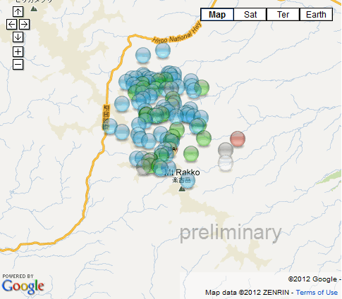
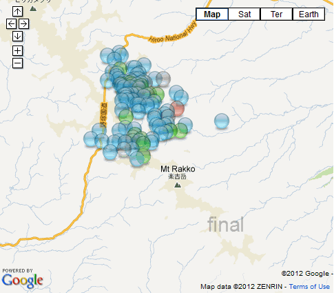
Hiroo, Hokkaido - Final data in from JMA
They (NIED and JMA) had 3 goes at the location and magnitudes
this map shows where (and where the othes thought it was) RAS the closest to JMA throughout.
goo.gl...
With all the aftershocks for 72 hours finalized they have shifted a bit, actually the whole bunch moved to the NW
this little animated gif shows the difference quite well
I didn't post the actual animation here as I know how annoying those can be, but here are the screenshots used in it.
I rewrote my page on the event, its a bit like a dog chasing its tail, you end up going around in circles for the first 72 hours, which seems a standard timeline for most strong quake aftershock series to taper out.
Hiroo, Hokkaido 5.8Mw
Timeline graph to be added yet
No use rushing in and plotting a bunch of early estimates for these, I like to give it at least 24 hrs before the first map, that way you get some
idea where the aftershocks are headed
Did a quick map for El Salvador 7.4 aftershocks yesterday for EQR, did 72 hours worth, used EMSC data this time. Haven't done the Network locations or history yet for that one.
27/08/2012 offshore Central America 7.4 aftershocks
and one for the Philippines, just the first 12 hours, Geofon data
31/8/2012 Philippines 7.6 aftershocks
I haven't done an ANSS History for this one yet, but heres Utsu's in the meantime, nothing in that spot, so a fresh rupture (since 2003 and 6+ anyway)
Utsu Philippines 1619AD to 2003AD
* I did it for Iran quake last month as a test, "time elapsed since Main Shock" entry on each aftershock tag, was hard work, as after the first 24hrs the formula didn't work . Just tried it again for Hiroo and by accident managed to get the format for the number of hours elapsed to roll over to the 2nd and 3rd days.
Its [h]:mm:ss, not hh:mm:ss
So I'll probably do it from now on on all my aftershock maps
Did a quick map for El Salvador 7.4 aftershocks yesterday for EQR, did 72 hours worth, used EMSC data this time. Haven't done the Network locations or history yet for that one.
27/08/2012 offshore Central America 7.4 aftershocks
and one for the Philippines, just the first 12 hours, Geofon data
31/8/2012 Philippines 7.6 aftershocks
I haven't done an ANSS History for this one yet, but heres Utsu's in the meantime, nothing in that spot, so a fresh rupture (since 2003 and 6+ anyway)
Utsu Philippines 1619AD to 2003AD
edit on 1-9-2012 by muzzy because: (no reason given)
* I did it for Iran quake last month as a test, "time elapsed since Main Shock" entry on each aftershock tag, was hard work, as after the first 24hrs the formula didn't work . Just tried it again for Hiroo and by accident managed to get the format for the number of hours elapsed to roll over to the 2nd and 3rd days.
Its [h]:mm:ss, not hh:mm:ss
So I'll probably do it from now on on all my aftershock maps
edit on 1-9-2012 by muzzy because: (no reason given)
Probably meaningless; but the average EQ size seems to bit high as of late. A lot of 4's and 5's.
further to post by muzzy
Timeline Graph added
all done from memory, lost my Excel Template for doing these.
Interesting how this quake graph didn't have the curve on the underside of the first few hours like most of the others I have done. compare
no mucking about, just got on with it right away, first aftershock was within 5 minutes, first mag 1 within 08 minutes and 6 seconds.
Could be the accuracy of the JMA that accounts for that.
reply to post by IZombie
a couple of mag 7's and the ensuing aftershocks in the last week would push those numbers up, About 29 alone for off El Salvador and still counting the Philippines ones
a couple of mag 7's and the ensuing aftershocks in the last week would push those numbers up, About 29 alone for off El Salvador and still counting the Philippines ones
edit on 1-9-2012 by muzzy because: (no reason given)
Originally posted by muzzy
No use rushing in and plotting a bunch of early estimates for these, I like to give it at least 24 hrs before the first map, that way you get some idea where the aftershocks are headed
Did a quick map for El Salvador 7.4 aftershocks yesterday for EQR, did 72 hours worth, used EMSC data this time. Haven't done the Network locations or history yet for that one.
27/08/2012 offshore Central America 7.4 aftershocks
done a page on that one now
Off Coast of Central America, 7.4Mw, 27/08/2012
aftershocks, network plots, historic quakes, etc........ starting to build a template for these
While I was doing that I dug up another bone
I have looked for this every now and again when something hits Central America, had it on favorites a few computers ago, but lost it. Just spent a good couple of hours trying to decipher Nicaragua's INETER earthquake site (I knew it came from in there somewhere). Finally found it webserver2.ineter.gob.ni...
Its a rolling list of earthquake events last 10 days for Central America.
I'll probably redo that aftershock map with this Ineter data, I like to use the local network when I can.
after I cut the lawn
reply to post by muzzy
Seems to be more than just the aftershocks tho. All of the quakes everywhere seem to be hitting 4/5+, unlike previously where there was mostly
Seems to be more than just the aftershocks tho. All of the quakes everywhere seem to be hitting 4/5+, unlike previously where there was mostly
reply to post by muzzy
Yum!! I shall have to add that to the list of future downloads in the program.
Its a rolling list of earthquake events last 10 days for Central America.
Yum!! I shall have to add that to the list of future downloads in the program.
reply to post by muzzy
1987 in the immediate area
Centennial catalog
Which of course does NOT mean that there were no earlier events, just that they did not get recorded in writing or folklore.
but heres Utsu's in the meantime, nothing in that spot, so a fresh rupture (since 2003 and 6+ anyway)
1987 in the immediate area
1987-06-06T18:40:29.470Z, 10.713, 126.051, 6.5 Mw, 17km
Centennial catalog
Which of course does NOT mean that there were no earlier events, just that they did not get recorded in writing or folklore.
Note to those waiting patiently in anticipation of the new release of the QVSData program...........
.....um hello anyone out there?
Oh well. Sorry it is delayed because the Australians have a problem with writing sensible XML files. I have found an alternative method, which actually will be much better as it happens, but it will be a couple of days to fix it.
Additionally there seems to be a possible problem with Vista (why am I nor surprised?). I shall address this as well.
Magnitude 3.3 earthquake shakes Los Angeles, quake centered close to Beverly Hills - USGS
2012-09-03 10:26:56 UTC
2012-09-03 03:26:56 UTC-07:00 at epicenter
2012-09-03 06:26:56 UTC-04:00 system time
Nearby Cities
0km (0mi) E of Beverly Hills, California
3km (2mi) WSW of West Hollywood, California
6km (4mi) WSW of Hollywood, California
6km (4mi) N of Culver City, California
572km (355mi) SSE of Sacramento, California
edit on 3-9-2012 by kennvideo because: info
Twitter Alerts U.S. Geological Survey to Philippines Quake
By Douglas MacMillan - Aug 31, 2012 9:17 PM GMT
www.bloomberg.com/news/2012-08-31/twitter-beats-u-s-geological-survey-to-philippines-quake-news.html
By Douglas MacMillan - Aug 31, 2012 9:17 PM GMT
www.bloomberg.com/news/2012-08-31/twitter-beats-u-s-geological-survey-to-philippines-quake-news.html
Twitter Inc., the microblogging service that lets more than 140 million users send short messages on everything from the mundane to the life-altering, tipped off the U.S. Geological Survey to the 7.6-magnitude earthquake that hit near the coast of the Philippines today.
The Reston, Virginia-based agency detected tweets about the earthquake one minute and seven seconds after the seismic event, which occurred at about 8:47 p.m. local time, Paul Earle, a USGS seismologist, said in a telephone interview.
(...)
The USGS occasionally receives false alarms from its prototype system, such as when Twitter users post messages about the song “Earthquake” by British musician Labrinth.
“It’s not foolproof,” Earle said.
EMBARGOED BY Nature
FOR RELEASE ON Wednesday, August 29, 2012 10:00 AM PDT
Wednesday, August 29, 2012
Scripps Researchers Pinpoint Hot Spots as Earthquake Trigger Points
Small droplets of friction-generated melts weaken faults and can lead to 'megaquakes'
Scripps Institution of Oceanography / University of California, San Diego
scrippsnews.ucsd.edu/Releases/?releaseID=1286
www.nature.com/nature/journal/v488/n7413/full/nature11370.html
‘Melt welt’ mechanism of extreme weakening of gabbro at seismic slip rates
* Kevin M. Brown
* Yuri Fialko
Institute of Geophysics and Planetary Physics, Scripps Institution of Oceanography, University of California, San Diego, La Jolla, California 92093, USA
Nature 488, 638–641 (30 August 2012) | doi:10.1038/nature11370
Received 14 December 2011 | Accepted 29 June 2012 | Published online 29 August 2012
Laboratory studies of frictional properties of rocks at slip velocities approaching the seismic range (~0.1–1 m s−1), and at moderate normal stresses (1–10 MPa), have revealed a complex evolution of the dynamic shear strength, with at least two phases of weakening separated by strengthening at the onset of wholesale melting1, 2, 3, 4. The second post-melting weakening phase is governed by viscous properties of the melt layer and is reasonably well understood5, 6. The initial phase of extreme weakening, however, remains a subject of much debate. Here we show that the initial weakening of gabbro is associated with the formation of hotspots and macroscopic streaks of melt (‘melt welts’), which partially unload the rest of the slip interface. Melt welts begin to form when the average rate of frictional heating exceeds 0.1–0.4 MW m−2, while the average temperature of the shear zone is well below the solidus (250–450 °C). Similar heterogeneities in stress and temperature are likely to occur on natural fault surfaces during rapid slip, and to be important for earthquake rupture dynamics.
Subject terms:
* Earth sciences
* Geophysics
* Geology
* Materials science
new topics
-
VP's Secret Service agent brawls with other agents at Andrews
Mainstream News: 36 minutes ago -
Sunak spinning the sickness figures
Other Current Events: 1 hours ago -
Nearly 70% Of Americans Want Talks To End War In Ukraine
Political Issues: 1 hours ago -
Late Night with the Devil - a really good unusual modern horror film.
Movies: 3 hours ago -
Cats Used as Live Bait to Train Ferocious Pitbulls in Illegal NYC Dogfighting
Social Issues and Civil Unrest: 4 hours ago -
The Good News According to Jesus - Episode 1
Religion, Faith, And Theology: 6 hours ago -
HORRIBLE !! Russian Soldier Drinking Own Urine To Survive In Battle
World War Three: 8 hours ago -
Bobiverse
Fantasy & Science Fiction: 11 hours ago -
Florida man's trip overseas ends in shock over $143,000 T-Mobile phone bill
Social Issues and Civil Unrest: 11 hours ago
top topics
-
Florida man's trip overseas ends in shock over $143,000 T-Mobile phone bill
Social Issues and Civil Unrest: 11 hours ago, 8 flags -
SETI chief says US has no evidence for alien technology. 'And we never have'
Aliens and UFOs: 15 hours ago, 7 flags -
Cats Used as Live Bait to Train Ferocious Pitbulls in Illegal NYC Dogfighting
Social Issues and Civil Unrest: 4 hours ago, 7 flags -
Former Labour minister Frank Field dies aged 81
People: 13 hours ago, 4 flags -
Bobiverse
Fantasy & Science Fiction: 11 hours ago, 3 flags -
Nearly 70% Of Americans Want Talks To End War In Ukraine
Political Issues: 1 hours ago, 2 flags -
Late Night with the Devil - a really good unusual modern horror film.
Movies: 3 hours ago, 2 flags -
VP's Secret Service agent brawls with other agents at Andrews
Mainstream News: 36 minutes ago, 2 flags -
HORRIBLE !! Russian Soldier Drinking Own Urine To Survive In Battle
World War Three: 8 hours ago, 2 flags -
Sunak spinning the sickness figures
Other Current Events: 1 hours ago, 0 flags
active topics
-
Ditching physical money
History • 19 • : 20241105 -
VP's Secret Service agent brawls with other agents at Andrews
Mainstream News • 11 • : budzprime69 -
Breaking Baltimore, ship brings down bridge, mass casualties
Other Current Events • 484 • : ThatSmellsStrange -
SETI chief says US has no evidence for alien technology. 'And we never have'
Aliens and UFOs • 39 • : SchrodingersRat -
Truth Social goes public, be careful not to lose your money
Mainstream News • 127 • : xuenchen -
15 Unhealthiest Sodas On The Market
Health & Wellness • 42 • : ThatSmellsStrange -
President BIDEN Vows to Make Americans Pay More Federal Taxes in 2025 - Political Suicide.
2024 Elections • 120 • : ImagoDei -
Nearly 70% Of Americans Want Talks To End War In Ukraine
Political Issues • 6 • : budzprime69 -
HORRIBLE !! Russian Soldier Drinking Own Urine To Survive In Battle
World War Three • 25 • : Freeborn -
Definitive 9.11 Pentagon EVIDENCE.
9/11 Conspiracies • 422 • : Zanti Misfit