It looks like you're using an Ad Blocker.
Please white-list or disable AboveTopSecret.com in your ad-blocking tool.
Thank you.
Some features of ATS will be disabled while you continue to use an ad-blocker.

Quake Watch 2012
page: 18share:
Originally posted by crazydaisy
In N. Indiana and our house just shook,
felt like a quake for sure but didn't last long.
Anyone else feel this?
And it just happened again. Not as strong
this time.edit on 20-1-2012 by crazydaisy because: (no reason given)
Just so you know cd, right after I saw your post I went on GEE and chose some stations in Indiana. I did appear to show some kind of strange event, registering around 90 microns/sec. It also had a very slight "follow up event". Honestly it looked like some kind of man made event, but I can't be sure. And 90 microns/sec is really not that much, so not sure what is going on.
reply to post by crazydaisy
You know actually, kind of looked like a snow avalanche signature, so please check your local news, papers, etc for any such thing in your area. Might help explain it.
You know actually, kind of looked like a snow avalanche signature, so please check your local news, papers, etc for any such thing in your area. Might help explain it.
reply to post by TrueAmerican
We are expecting a snow storm
and it is probably already in the
state. Will keep an eye on the
news - you have been very helpful.
Much appreciated.
We are expecting a snow storm
and it is probably already in the
state. Will keep an eye on the
news - you have been very helpful.
Much appreciated.
reply to post by this_is_who_we_are
P457 cleaned
Looks pretty flat to me. Raw plots are no good. You need detrended/cleaned plots
Here is P456
P457 cleaned
Looks pretty flat to me. Raw plots are no good. You need detrended/cleaned plots
Here is P456
Originally posted by PuterMan
Raw plots are no good. You need detrended/cleaned plots
If raw plots are no good, then what are they doing published on the web, and why did this organization invest millions in equipment and personnel to obtain them?
Magnitude mb 6.2
Region FLORES REGION, INDONESIA
Date time 2012-01-20 20:32:54.0 UTC
Location 8.86 S ; 119.64 E
Depth 116 km
Distances 387 km E Mataram (pop 318,674 ; local time 04:32:54.0 2012-01-21)
95 km W Ruteng (pop 34,569 ; local time 04:32:54.0 2012-01-21)
EMSC
EDIT: Downgraded to a 5.8
Region FLORES REGION, INDONESIA
Date time 2012-01-20 20:32:54.0 UTC
Location 8.86 S ; 119.64 E
Depth 116 km
Distances 387 km E Mataram (pop 318,674 ; local time 04:32:54.0 2012-01-21)
95 km W Ruteng (pop 34,569 ; local time 04:32:54.0 2012-01-21)
EMSC
EDIT: Downgraded to a 5.8
edit on 20-1-2012 by Hellas because: (no reason given)
reply to post by westcoast
Well I have to say that is EXACTLY what it sounds like. Big rumble followed by chatter getting slower and slower.
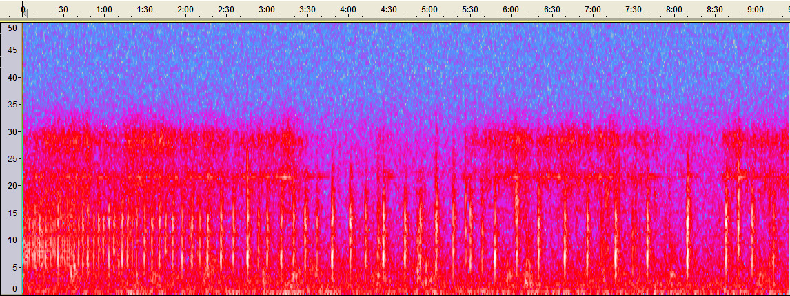
RCS201201811755.zip
Zipped to make it a bit smaller but it is still a 3.3Mb download.
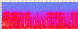
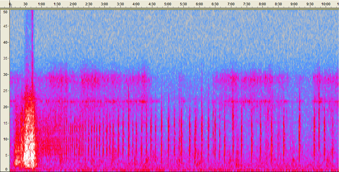
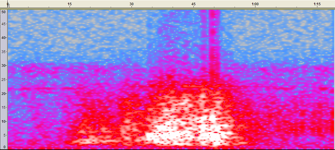
Spectrum of sound file
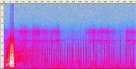
Spectrum of main 'rumble'. Note no very low 1Hz signal. Not seismic signature at all.
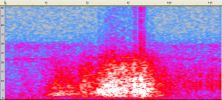
Spectrum of the 'blips'. Quite high frequency (relatively) 5 - 15Hz
PNSN's best guess on this recent activity is that it was an ice avalanche followed by a big chunch chattering down the side.....problem is, this configuration is backwards from what is normally seen. usually, it is the chattering building up to the avalanche.
Well I have to say that is EXACTLY what it sounds like. Big rumble followed by chatter getting slower and slower.
RCS201201811755.zip
Zipped to make it a bit smaller but it is still a 3.3Mb download.
Spectrum of sound file
Spectrum of main 'rumble'. Note no very low 1Hz signal. Not seismic signature at all.
Spectrum of the 'blips'. Quite high frequency (relatively) 5 - 15Hz
reply to post by TrueAmerican
To obtain them, de-trend them and clean them giving you the steps taken to get the results which is correct procedure rather than just showing the cleaned version with no idea what the spread was before the adjustments were made.
Maybe I should have said 'raw plots are no good to us' since we do not have the facilities to properly analyse them.
edit on 20/1/2012 by
PuterMan because: (no reason given)
Magnitude mb 5.6
Region KEPULAUAN SANGIHE, INDONESIA
Date time 2012-01-20 22:50:54.0 UTC
Location 4.78 N ; 125.21 E
Depth 60 km
Distances 147 km S Dadiangas (pop 432,309 ; local time 06:50:54.1 2012-01-21)
116 km S Glan (pop 24,256 ; local time 06:50:54.1 2012-01-21)
75 km SW Sarangani (pop 7,506 ; local time 06:50:54.1 2012-01-21)
EMSC
EDIT: AGAIN downgraded to a 5.4. What is up with those guys today...
edit on 20-1-2012 by Hellas because: (no reason given)
reply to post by katfish
When? Is this documented? Which areas?
This is quite important as the theory of earthquakes being affected by atmospheric pressure seems to be appearing more and more and anything that can assist in documenting this is useful.
.....did some ground shifting? Happens here before big storms
When? Is this documented? Which areas?
This is quite important as the theory of earthquakes being affected by atmospheric pressure seems to be appearing more and more and anything that can assist in documenting this is useful.
.
People in Taupo have reported feeling an earthquake this morning, although it was only a magnitude [color=ECD672 ]2.3 on the Richter Scale.
It happened just before 7.30, and was centred 10 kilometres north of the city, at a depth of just three kilometres
news link
Heres the felt reports from Geonet
MM4 Largely observed 110
Acacia Bay [2], Hilltop [5], Monaco [1], Nukuhau [25], Rangatira Park [2], Richmond Heights [5], Tauhara [3], Tauhara [1], Taupo [63], Waipahihi [2], Wairakei [1]
MM3 Weak 6
Hilltop [1], Kinloch [1], Nukuhau [1], Onehunga [1], Taupo [1], Waipahihi [1]
Total [color=ECD672 ]116
www.geonet.org.nz...
Talk about being sensitive
Still, when you are living inside the cone of a super volcano you'd be on edge too
edit on 20-1-2012 by muzzy because: (no reason
given)
UK starting to make a habit of this now?
2012/01/19 18:12:39.7 53.052 -2.105 3 1.8 STOKE-ON-TRENT, STAFFS
EMSC
Rainbows
Jane
2012/01/19 18:12:39.7 53.052 -2.105 3 1.8 STOKE-ON-TRENT, STAFFS
EMSC
Rainbows
Jane
Magnitude
4.8
Date-Time
Saturday, January 21, 2012 at 03:19:51 UTC
Saturday, January 21, 2012 at 03:19:51 PM at epicenter
Time of Earthquake in other Time Zones
Location
65.089°S, 177.698°E
Depth
10.1 km (6.3 miles)
Region
BALLENY ISLANDS REGION
Distances
275 km (170 miles) NNW of Scott Island, Antarctica
714 km (443 miles) E of Young Island, Balleny Islands
1469 km (912 miles) NNE of McMurdo Station, Antarctica
2653 km (1648 miles) S of WELLINGTON, New Zealand
Location Uncertainty
horizontal +/- 37.8 km (23.5 miles); depth +/- 2.9 km (1.8 miles)
Parameters
NST= 19, Nph= 19, Dmin=>999 km, Rmss=0.54 sec, Gp=133°,
M-type=body wave magnitude (Mb), Version=6
Source
Magnitude: USGS NEIC (WDCS-D)
Location: USGS NEIC (WDCS-D)
Event ID
usc0007phk
earthquake.usgs.gov...
reply to post by berkeleygal
nice S-wave of that one on LISS SNZO at 3:30
Looking at the size of that I'd say the traces I haven't been able to ID on SNZO have all been from down that way, some of them are even smaller (but still the same shape) so possibly less that the Mag 4.5 cut-off point that USGS has.
There are usually a couple a day I can't pin down from the lists.
LISS SNZO Archive
edit on 20-1-2012 by muzzy because: missed an r
2012-01-21 16:13:12.3 03min ago
36.65 N 21.81 E 10 2.4 GREECE
2012-01-21 16:05:13.6
11min ago
38.26 N 22.15 E 10 3.1 GREECE
2012-01-21 15:43:27.4 34min ago
38.74 N 22.70 E 10 2.2 GREECE
2012-01-21 15:38:30.1 39min ago
38.42 N 21.08 E 10 2.0 GREECE
2012-01-21 14:53:31.8 1hr 24min ago
39.11 N 22.04 E 10 3.3 GREECE
EMSC
This is a real dangerous location for so many shakes in just 1,5 hours. This region has produced many fatal quakes in the past. I hope that those are not foreshocks
edit on 21-1-2012 by Hellas because: (no reason given)
earthquake.usgs.gov...
PAGER report
There could be damage with one area in the MMI Vi range. (See pager report)
Magnitude 6.2
Date-Time
Saturday, January 21, 2012 at 18:47:15 UTC
Saturday, January 21, 2012 at 12:47:15 PM at epicenter
Location 14.959°N, 93.107°W
Depth 66.1 km (41.1 miles)
Region OFFSHORE CHIAPAS, MEXICO
Distances
57 km (35 miles) SSW (203°) from Mapastepec, Chiapas, Mexico
72 km (44 miles) WSW (253°) from Huixtla, Chiapas, Mexico
82 km (51 miles) S (172°) from Pijijiapan, Chiapas, Mexico
89 km (55 miles) W (274°) from Tapachula, Chiapas, Mexico
281 km (174 miles) W (278°) from GUATEMALA CITY, Guatemala
Location Uncertainty horizontal +/- 15.8 km (9.8 miles); depth +/- 10.1 km (6.3 miles)
Parameters NST=331, Nph=337, Dmin=179.2 km, Rmss=1.29 sec, Gp= 97°,
M-type=regional moment magnitude (Mw), Version=8
Source
Magnitude: USGS NEIC (WDCS-D)
Location: USGS NEIC (WDCS-D)
Event ID usc0007pnj
PAGER report
There could be damage with one area in the MMI Vi range. (See pager report)
edit on 21/1/2012 by PuterMan because: (no reason given)
reply to post by PuterMan
You beat me to it!
Anyways, a decent jolt, that one. Showed up nicely on a couple of seismos I'm watching on GEE. One is in Memphis, TN, the other in Bauxite, AR (just SW of Little Rock):
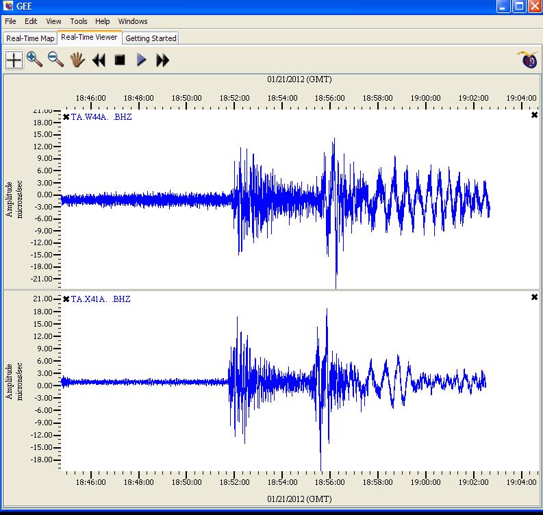
Acknowledgements: source of image is from my GEE display. (GEE is available free here)
You beat me to it!
Anyways, a decent jolt, that one. Showed up nicely on a couple of seismos I'm watching on GEE. One is in Memphis, TN, the other in Bauxite, AR (just SW of Little Rock):
Acknowledgements: source of image is from my GEE display. (GEE is available free here)
source(earthquake.usgs.gov...
TextMagnitude 6.2 Date-Time Saturday, January 21, 2012 at 18:47:15 UTC Saturday, January 21, 2012 at 12:47:15 PM at epicenter Time of Earthquake in other Time Zones Location 14.959°N, 93.107°W Depth 66.1 km (41.1 miles) Region OFFSHORE CHIAPAS, MEXICO Distances 91 km (56 miles) W of Tapachula, Chiapas, Mexico 143 km (88 miles) SSE of Tonala, Chiapas, Mexico 171 km (106 miles) W of Quetzaltenango, Guatemala 811 km (503 miles) SE of MEXICO CITY, D.F., Mexico Location Uncertainty horizontal +/- 15.8 km (9.8 miles); depth +/- 10.1 km (6.3 miles) Parameters NST=331, Nph=337, Dmin=179.2 km, Rmss=1.29 sec, Gp= 97°, M-type=regional moment magnitude (Mw), Version=8
new topics
-
I hate dreaming
Rant: 15 minutes ago -
Is the origin for the Eye of Horus the pineal gland?
Philosophy and Metaphysics: 2 hours ago -
Man sets himself on fire outside Donald Trump trial
Mainstream News: 2 hours ago -
Biden says little kids flip him the bird all the time.
2024 Elections: 2 hours ago -
The Democrats Take Control the House - Look what happened while you were sleeping
US Political Madness: 2 hours ago -
Sheetz facing racial discrimination lawsuit for considering criminal history in hiring
Social Issues and Civil Unrest: 2 hours ago -
In an Historic First, In N Out Burger Permanently Closes a Location
Mainstream News: 4 hours ago -
MH370 Again....
Disaster Conspiracies: 5 hours ago -
Are you ready for the return of Jesus Christ? Have you been cleansed by His blood?
Religion, Faith, And Theology: 7 hours ago -
Chronological time line of open source information
History: 9 hours ago
top topics
-
In an Historic First, In N Out Burger Permanently Closes a Location
Mainstream News: 4 hours ago, 14 flags -
The Democrats Take Control the House - Look what happened while you were sleeping
US Political Madness: 2 hours ago, 9 flags -
Thousands Of Young Ukrainian Men Trying To Flee The Country To Avoid Conscription And The War
Other Current Events: 15 hours ago, 8 flags -
A man of the people
Medical Issues & Conspiracies: 10 hours ago, 8 flags -
Man sets himself on fire outside Donald Trump trial
Mainstream News: 2 hours ago, 7 flags -
Biden says little kids flip him the bird all the time.
2024 Elections: 2 hours ago, 6 flags -
4 plans of US elites to defeat Russia
New World Order: 12 hours ago, 4 flags -
Are you ready for the return of Jesus Christ? Have you been cleansed by His blood?
Religion, Faith, And Theology: 7 hours ago, 3 flags -
Is the origin for the Eye of Horus the pineal gland?
Philosophy and Metaphysics: 2 hours ago, 3 flags -
Sheetz facing racial discrimination lawsuit for considering criminal history in hiring
Social Issues and Civil Unrest: 2 hours ago, 3 flags
active topics
-
Man sets himself on fire outside Donald Trump trial
Mainstream News • 19 • : imitator -
Thousands Of Young Ukrainian Men Trying To Flee The Country To Avoid Conscription And The War
Other Current Events • 28 • : Xtrozero -
12 jurors selected in Trump criminal trial
US Political Madness • 89 • : ImagoDei -
Is the origin for the Eye of Horus the pineal gland?
Philosophy and Metaphysics • 4 • : JoelSnape -
Biden says little kids flip him the bird all the time.
2024 Elections • 9 • : FlyersFan -
Fossils in Greece Suggest Human Ancestors Evolved in Europe, Not Africa
Origins and Creationism • 72 • : Xtrozero -
I hate dreaming
Rant • 0 • : FlyersFan -
MH370 Again....
Disaster Conspiracies • 8 • : Lazy88 -
Do we live in a simulation similar to The Matrix 1999?
ATS Skunk Works • 27 • : purplemer -
911 emergency lines are DOWN across multiple states
Breaking Alternative News • 8 • : nugget1