It looks like you're using an Ad Blocker.
Please white-list or disable AboveTopSecret.com in your ad-blocking tool.
Thank you.
Some features of ATS will be disabled while you continue to use an ad-blocker.

Quake Watch 2012
page: 176share:
We were well prepared for disaster anyway, our Spa Pool sprung a seal on a knob a few days ago so we shut it down and waiting for a replacement seal
from Auckland, so gave it a clean and refilled it with fresh water, no chemicals added yet, so 500+ litres at hand
Plus our usual 60 litres of emergency supply in containers.
I'm off to sleep hopefully, 2 coffees and 4 cigs to calm the nerves
Plus our usual 60 litres of emergency supply in containers.
I'm off to sleep hopefully, 2 coffees and 4 cigs to calm the nerves
reply to post by muzzy
I have changed the map on my El Hierro post (see signature) and it should work OK now. It is now specific to Google Maps.
Interesting stuff it one is interested in the technible bits, otherwise just go to sleep or let the eyes glaze.
I was aware that GM did not use the styles properly but it actually is worse than that. If you have a GM KMZ with more than one level of folder....
folder
inner folder
/inner folder
/folder
....the styles that supply the icon are not seen at all and you get paddles. If you only have one folder the first folder visibility turns everything off and the rest seems haphazard,
On the other hand if you do not use icon styles at all, and basically there is little of them used by Maps, the folder thing works OK.
Problem is if you run a Maps KMZ in Google Earth without styles every single placemark (way-point) is labelled and in a multiple earthquake list scenario that is worse than useless.
I am going to have to change the QVSData program yet again to create Google Maps only files, or Google Earth files. The main difference is that every line has to have a reference to the icon in Google Maps which makes the whole thing larger. On the other hand no label styles are required so a bit is saved there.
edit on 3/7/2012 by PuterMan because: (no reason given)
Puterman, I especially enjoyed the video on your El Hierro page, showing how the epicenters migrated west.
Well done.
Calling John Vidale, hello....... What is (not) going on with the PNSN tremor page?
It hasn't been updated since 29 June. Is the system experiencing difficulties again? I was trying to see if there was any tremor associated with this Mag 2.4 located just offshore Gold Beach.
Well done.
Calling John Vidale, hello....... What is (not) going on with the PNSN tremor page?
It hasn't been updated since 29 June. Is the system experiencing difficulties again? I was trying to see if there was any tremor associated with this Mag 2.4 located just offshore Gold Beach.
edit on 7/3/2012 by Olivine because: (no reason given)
2-3 hrs sleep
Pretty low figures here too;
Global CMT
LDEO measuring S wave
Will hold off adding it to the MWE 7+ map for now, but it can go on the 1840-2012 Mag 6+ and 2012 5+ maps as their data is all Geonet anyway, as a 7.148ML, 6.2Ms, 6.3Mw
Interactive 6+ NZ Historic Quakes Google Map centred on last nights quake
Interesting notes about Google (after that debacle of icons off centre a week ago) and Blogger, which is run by Google.
I wrote that NZ 6+ post in 2011 on Blogspot , before the Pegusus Bay 6.0, so that needed updating as well.
Then I tried to change the address of the post from tauhouanga.blogspot.co.nz/2012/05/1840-2011 to tauhouanga.blogspot.co.nz/2012/05/1840-2012 to keep it up to date. No can do, I'd have to delete that one and write a new one.
Also you can no longer set the date or alter the date the post is posted, which you previously could do, this was handy when doing historic posts to get them is sequence.
* Note to Puterman. I loaded that Mag6+ file that you kindly created for me when the icons were playing up.The icons were in the right place, and from memory the popup tags had the details inside.
When I added last nights quake to the CSV file it loaded fine on Google Earth, so I saved it under the same name. On Google Maps the icons were there, but there was nothing in the popup tags except "Address" and an "x". I renamed the KML file and sent that through Dropbox rewrote the i- frame html etc and all is good now.
Google are really making it hard to like using Blogger!, I think I'll transfer all my Blogger pages over to Wordpress.
I wish someone else would get into mapping, and offer the i-frame creation option, Yahoo do some stuff but when you use Yahoo the map comes up in Google anyway.
I had a go at OpenStreetMap.org a few months ago, where you have to register, it seemed to me that was more for map development than day to day use.
Pretty low figures here too;
Global CMT
201207031036A OFF W. COAST OF N. ISLAND NEW ZEALAND
Date: 2012/ 7/ 3 Centroid Time: 10:36:20.2 GMT
Lat= -40.00 Lon= 173.67
Depth=229.9 Half duration= 3.5
Centroid time minus hypocenter time: 4.2
Moment Tensor: Expo=25 0.282 0.842 -1.120 2.850 -2.110 0.263
Mw = 6.3 mb = 0.0 Ms = 6.2 Scalar Moment = 3.69e+25
Fault plane: strike=32 dip=16 slip=173
Fault plane: strike=128 dip=88 slip=74
LDEO measuring S wave
2012 7 3 10 36 24.0 -40.25 174.25 33.0 6.1 COOK STRAIT, NEW ZEALAND
Will hold off adding it to the MWE 7+ map for now, but it can go on the 1840-2012 Mag 6+ and 2012 5+ maps as their data is all Geonet anyway, as a 7.148ML, 6.2Ms, 6.3Mw
edit on 3-7-2012 by muzzy because: (no reason
given)
Interactive 6+ NZ Historic Quakes Google Map centred on last nights quake
Interesting notes about Google (after that debacle of icons off centre a week ago) and Blogger, which is run by Google.
I wrote that NZ 6+ post in 2011 on Blogspot , before the Pegusus Bay 6.0, so that needed updating as well.
Then I tried to change the address of the post from tauhouanga.blogspot.co.nz/2012/05/1840-2011 to tauhouanga.blogspot.co.nz/2012/05/1840-2012 to keep it up to date. No can do, I'd have to delete that one and write a new one.
Also you can no longer set the date or alter the date the post is posted, which you previously could do, this was handy when doing historic posts to get them is sequence.
* Note to Puterman. I loaded that Mag6+ file that you kindly created for me when the icons were playing up.The icons were in the right place, and from memory the popup tags had the details inside.
When I added last nights quake to the CSV file it loaded fine on Google Earth, so I saved it under the same name. On Google Maps the icons were there, but there was nothing in the popup tags except "Address" and an "x". I renamed the KML file and sent that through Dropbox rewrote the i- frame html etc and all is good now.
Google are really making it hard to like using Blogger!, I think I'll transfer all my Blogger pages over to Wordpress.
I wish someone else would get into mapping, and offer the i-frame creation option, Yahoo do some stuff but when you use Yahoo the map comes up in Google anyway.
I had a go at OpenStreetMap.org a few months ago, where you have to register, it seemed to me that was more for map development than day to day use.
edit on 3-7-2012 by muzzy because: (no reason given)
edit on 3-7-2012 by muzzy because: (no reason given)
reply to post by PuterMan
Yep I see July2 now.
Yep Google Maps seems to only use one size icon, 32x32pixels, so styles in the KML make no difference.
Making smaller icons won't work, they still come out 32x32 and come out blurred. See how your smaller Aqua icons are not as sharp as the Orange ones.
Yep to get the list on the left hand column you have to give each item/marker a label/ name.
Real PITA
reply to post by muzzy
If that was the case all the SNZO seismograms would be trashed but they are not as you demonstrated.
All of the 00 location plots are screwed, BHZ, LHZ and VHZ but the 10 locations are OK.
SNZO.IU.10.VHZ.2012.185
SNZO.IU.10.LHZ.2012.185
SNZO.IU.10.BHZ.2012.185
re above post
Actually they are all the same size 64 x 64


I need to look into scaling in maps further it would seem.
If that was the case all the SNZO seismograms would be trashed but they are not as you demonstrated.
All of the 00 location plots are screwed, BHZ, LHZ and VHZ but the 10 locations are OK.
SNZO.IU.10.VHZ.2012.185
SNZO.IU.10.LHZ.2012.185
SNZO.IU.10.BHZ.2012.185
edit on 3/7/2012 by PuterMan because: Green decoration was required.
re above post
See how your smaller Aqua icons are not as sharp as the Orange ones.
Actually they are all the same size 64 x 64
I need to look into scaling in maps further it would seem.
edit on 3/7/2012 by PuterMan because: (no reason given)
reply to post by PuterMan
I made some smaller orbs inside a 32x32 clear background canvas and thought that would solve the issue, but they still came out the same size on GMaps. In the end I gave up trying, and all my icons are 32x32 now.
How did you get them Aqua ones smaller then? did you write something in the KML to force GMaps to recognise the style?
dl.dropbox.com...
dl.dropbox.com...
Here is an odd little swarm of quakes just north Half Moon Bay, CA. I've never seen one in this location before.
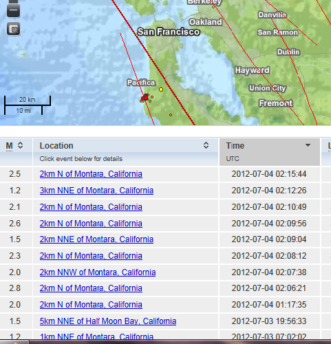
source
It looks to be on a fault parallel to the San Andreas, and about 10 km west.
The depths are averaging near 8.5 km and the magnitudes are small--nothing larger than 2.8.
Just letting off a little stress, I guess.
source
It looks to be on a fault parallel to the San Andreas, and about 10 km west.
The depths are averaging near 8.5 km and the magnitudes are small--nothing larger than 2.8.
Just letting off a little stress, I guess.
reply to post by Olivine
Well THAT's very interesting! I have been busy all afternoon and have not checked USGS since this morning.
Hmmm. B.O.B ready??? youbetcha!
Well THAT's very interesting! I have been busy all afternoon and have not checked USGS since this morning.
Hmmm. B.O.B ready??? youbetcha!
4.8 2012/07/04 00:04:00 -59.126 148.972 10.3 WEST OF MACQUARIE ISLAND
earthquake.usgs.gov...
Sure about that
looks bigger than that here on LISS SNZO
sure enough
2012 7 4 0 4 0.0 -59.00 149.00 33.0 5.5 WEST OF MACQUARIE ISLAND
www.ldeo.columbia.edu...
yeah I know its the S-wave, but still why no Mw reading from USGS? should be 5.27Mw at least by using the Geofon calculation method for USGS.
keeping the numbers down on the moderate sized quakes count too?
edit on 3-7-2012 by muzzy because: (no reason given)
Turkey - June 2012
- 1849 earthquakes on this interactive map
* File that loads the icons is 1.5MB in size, it may take some time to load or you may need to click refresh/ reload current page to see them if they don't load right away, especially if you have not got Broadband.
Chile tomorrow
- 1849 earthquakes on this interactive map
* File that loads the icons is 1.5MB in size, it may take some time to load or you may need to click refresh/ reload current page to see them if they don't load right away, especially if you have not got Broadband.
Chile tomorrow
Totally off topic but I hope the Mods will forgive.
Watch out for the UFOs. Quite why anyone would wish for independence from the Crown I cannot imagine
El hierro had fewer quakes each day over the last three days. Some are cherry picking the bad sections and showing the seismos - for example this for early today
Today 00hrs to 01hrs
Whereas the full day at 0700 UTC has no further activity.
This image will change over the day.
Happy Independence Day
Watch out for the UFOs. Quite why anyone would wish for independence from the Crown I cannot imagine
El hierro had fewer quakes each day over the last three days. Some are cherry picking the bad sections and showing the seismos - for example this for early today
Today 00hrs to 01hrs
Whereas the full day at 0700 UTC has no further activity.
This image will change over the day.
edit on 4/7/2012 by PuterMan because: (no reason given)
Mystery disappearance of Sumatran earthquakes
USGS were being questioned today by detectives from the Earthquake Protection Squad about the curious disappearance of two Magnitude 6 earthquakes. Last seen on or about the 12th April, 2012 it appears that a person or persons unknown have removed these quakes. Despite continuous waterboarding for several hours the database would not yield any information.
usgs 11/04/2012 14:32 6.1 Off W. Coast Of Northern Sumatra
usgs 11/04/2012 14:40 6 Off W. Coast Of Northern Sumatra
Cross checking with other information sources reveals that these two quakes, known by the USGS as 2012zgmw and 2012zgmn have either been removed from other lists or may never have existed.
These two quakes were not in the original listing but were added after the event. Seems it may have been in error. This reduces the year total of Mag 6 to 64.
And another one, and another one, and another one bites the dust
usgs 11/04/2012 14:46 6 Offshore Taitung City. Taiwan
They must have been having a bad quake day on the 11th April!
2012zgm1
And then there were 63!
edit on 4/7/2012 by PuterMan because: (no reason given)
Originally posted by PuterMan
Happy Independence Day
Watch out for the UFOs. Quite why anyone would wish for independence from the Crown I cannot imagine
Funny man! And thank you. Reading your most recent post below, you're on a comedic roll today, PM.
I justed looked on the USGS Errata page, I didn't find your missing Sumatra quakes, but the 'short-lived' offshore northern CA mag 5.9 from the same day (2012/04/11) is listed.
Maybe this latest missing duo will be added to this page shortly?
reply to post by Olivine
Doubt it unless they suddenly find my pages and go "OMG than darn PuterMan has them. Better own up! Drat, thought everyone had forgotten about those!"
Maybe this latest missing duo will be added to this page shortly?
Doubt it unless they suddenly find my pages and go "OMG than darn PuterMan has them. Better own up! Drat, thought everyone had forgotten about those!"
All material from compilation by Science Media Centre (New Zealand)
www.sciencemediacentre.co.nz/2012/06/29/alpine-fault-research-shakes-up-nz-news/
-
www.sciencemag.org/content/336/6089/1690.abstract
8000-year quake record improves understanding of Alpine Fault
June 28, 2012
phys.org/news/2012-06-year-quake-alpine-fault.html
30% chance of 8 quake
By Laura Mills
www.greystar.co.nz/content/30-chance-8-quake
www.sciencemediacentre.co.nz/2012/06/29/alpine-fault-research-shakes-up-nz-news/
-
www.sciencemag.org/content/336/6089/1690.abstract
Science 29 June 2012:
Vol. 336 no. 6089 pp. 1690-1693
DOI: 10.1126/science.1218959
* Report
Major Earthquakes Occur Regularly on an Isolated Plate Boundary Fault
1. Kelvin R. Berryman1,*,
2. Ursula A. Cochran1,
3. Kate J. Clark1,
4. Glenn P. Biasi2,
5. Robert M. Langridge1,
6. Pilar Villamor1
- Author Affiliations
1.
1GNS Science, Post Office Box 30-368, Lower Hutt 5040, New Zealand.
2.
2Seismological Laboratory, University of Nevada-Reno, Reno, NV 89557, USA.
1. ↵*To whom correspondence should be addressed E-mail: [email protected]
Abstract
The scarcity of long geological records of major earthquakes, on different types of faults, makes testing hypotheses of regular versus random or clustered earthquake recurrence behavior difficult. We provide a fault-proximal major earthquake record spanning 8000 years on the strike-slip Alpine Fault in New Zealand. Cyclic stratigraphy at Hokuri Creek suggests that the fault ruptured to the surface 24 times, and event ages yield a 0.33 coefficient of variation in recurrence interval. We associate this near-regular earthquake recurrence with a geometrically simple strike-slip fault, with high slip rate, accommodating a high proportion of plate boundary motion that works in isolation from other faults. We propose that it is valid to apply time-dependent earthquake recurrence models for seismic hazard estimation to similar faults worldwide.
* Received for publication 10 January 2012.
* Accepted for publication 4 May 2012.
8000-year quake record improves understanding of Alpine Fault
June 28, 2012
phys.org/news/2012-06-year-quake-alpine-fault.html
(...)
The investigation found the mean interval between large earthquakes on the fault is 330 years and two thirds of the intervals were between 260 and 400 years. As with many natural systems, there was a spread of intervals with the longest being about 510 years and the shortest about 140 years.
The Alpine Fault extends about 600km along the spine of the South Island between Milford Sound and Marlborough. When it ruptures, it produces an earthquake of about magnitude 8.0.
(...)
Based on this research, scientists have estimated there is a 30% probability of a large earthquake on the Alpine Fault in the next 50 years. This is at the higher end of existing estimates, which were based on only the last four large quakes on the fault. Scientists have more confidence in this new estimate as it is based on a much longer earthquake record.
(...)
For project co-leader Ursula Cochran, also of GNS Science, the long earthquake record they uncovered highlighted the inevitability of a major earthquake occurring on the southern section of the Alpine Fault in the future.
“The last earthquake occurred about 295 years ago, so there is no better time than the present to prepare for the next one,” Dr Cochran said.
At the household level, these measures include emergency kits, anchoring furniture, removal of old-style chimneys, and family communication plans. At the local community level, measures could include planning for the care of the elderly and young if the community is isolated, and identifying skills and equipment helpful in a disaster.
(...)
30% chance of 8 quake
By Laura Mills
www.greystar.co.nz/content/30-chance-8-quake
(...)
Auckland University professor of biostatistics Thomas Lumley said that using the numbers in the paper, “I get 32% chance at 50 years, and 50% chance at about 80 years”.
“The risks are high, but that’s because it seems to be an unusually regular fault.”
Long earthquake records have been obtained from only about four other faults around the world, including the San Andreas Fault, in California. The latest findings underpin an idea over 100 years old — that some faults might rupture regularly, rather than at
random or in clusters.
Other faults that have similar characteristics to the Alpine Fault include sections of the North Anatolian Fault, in Turkey, and the Denali Fault, in Alaska.
Chile - June 2012
- 338 earthquakes on this interactive map
Due to the narrowness of Chile I was able to put 2 maps side by side, so made a 4+ map as well.
EQArchives
Greece and Turkey now have maps showing "all" and "3+" quakes for June and July (Turkey and Greece tabs at top of the page I linked to above)
I've started converting Utsu's historic data to maps for each country as well (click on "Utsu" tab),
thought it would be OK on this blog, rather than interfering with MWE7+, as I am lifting 6+ data.
Just doing China now, 2,353,281 people killed by earthquakes 1767 to 2008
- 338 earthquakes on this interactive map
Due to the narrowness of Chile I was able to put 2 maps side by side, so made a 4+ map as well.
EQArchives
Greece and Turkey now have maps showing "all" and "3+" quakes for June and July (Turkey and Greece tabs at top of the page I linked to above)
I've started converting Utsu's historic data to maps for each country as well (click on "Utsu" tab),
thought it would be OK on this blog, rather than interfering with MWE7+, as I am lifting 6+ data.
edit on 4-7-2012 by muzzy because: missed a ]
Just doing China now, 2,353,281 people killed by earthquakes 1767 to 2008
edit on 4-7-2012 by muzzy because: Aren't rainy days
wonderful
I hope this does not escalate to bigger and not so better things!!
earthquake.usgs.gov...
Oops.... 5.1 Leeward Islands.
earthquake.usgs.gov...
Oops.... 5.1 Leeward Islands.
edit on 4-7-2012 by radpetey because: (no reason given)
edit on 4-7-2012 by radpetey because: (no
reason given)
reply to post by radpetey
earthquake.usgs.gov/earthquakes/dyfi/events/us/b000ayih/us/index.html
Jul 4, 6:18 PM EDT
5.1 quake shakes Anguilla; no damages reported
hosted.ap.org/dynamic/stories/C/CB_ANGUILLA_EARTHQUAKE?SITE=AP
earthquake.usgs.gov/earthquakes/dyfi/events/us/b000ayih/us/index.html
Jul 4, 6:18 PM EDT
5.1 quake shakes Anguilla; no damages reported
hosted.ap.org/dynamic/stories/C/CB_ANGUILLA_EARTHQUAKE?SITE=AP
THE VALLEY, Anguilla (AP) -- An earthquake has shaken the tiny Caribbean island of Anguilla. There are no reports of injuries or damage.
The U.S. Geological Survey reports the quake's preliminary magnitude as 5.1 and says the epicenter was about 6 miles (10 kilometers) east-southeast of Anguilla's capital, The Valley. But it says the quake occurred far below the surface, about 55 miles (88 kilometers) down - a depth that tends to lessen the power of a tremor's shaking.
Police constable Terry Sylvester tells The Associated Press that it was the strongest earthquake he has ever felt but says residents have not reported any damage.
© 2012 The Associated Press
new topics
-
Supreme Court Oral Arguments 4.25.2024 - Are PRESIDENTS IMMUNE From Later Being Prosecuted.
Above Politics: 30 minutes ago -
Krystalnacht on today's most elite Universities?
Social Issues and Civil Unrest: 39 minutes ago -
Chris Christie Wishes Death Upon Trump and Ramaswamy
Politicians & People: 1 hours ago -
University of Texas Instantly Shuts Down Anti Israel Protests
Education and Media: 3 hours ago -
Any one suspicious of fever promotions events, major investor Goldman Sachs card only.
The Gray Area: 5 hours ago -
God's Righteousness is Greater than Our Wrath
Religion, Faith, And Theology: 9 hours ago
top topics
-
VP's Secret Service agent brawls with other agents at Andrews
Mainstream News: 14 hours ago, 11 flags -
Nearly 70% Of Americans Want Talks To End War In Ukraine
Political Issues: 15 hours ago, 5 flags -
Sunak spinning the sickness figures
Other Current Events: 15 hours ago, 5 flags -
Electrical tricks for saving money
Education and Media: 13 hours ago, 4 flags -
Late Night with the Devil - a really good unusual modern horror film.
Movies: 17 hours ago, 3 flags -
Krystalnacht on today's most elite Universities?
Social Issues and Civil Unrest: 39 minutes ago, 3 flags -
Any one suspicious of fever promotions events, major investor Goldman Sachs card only.
The Gray Area: 5 hours ago, 2 flags -
University of Texas Instantly Shuts Down Anti Israel Protests
Education and Media: 3 hours ago, 2 flags -
Supreme Court Oral Arguments 4.25.2024 - Are PRESIDENTS IMMUNE From Later Being Prosecuted.
Above Politics: 30 minutes ago, 1 flags -
Chris Christie Wishes Death Upon Trump and Ramaswamy
Politicians & People: 1 hours ago, 0 flags
active topics
-
University of Texas Instantly Shuts Down Anti Israel Protests
Education and Media • 49 • : Vermilion -
Nearly 70% Of Americans Want Talks To End War In Ukraine
Political Issues • 68 • : FlyersFan -
Candidate TRUMP Now Has Crazy Judge JUAN MERCHAN After Him - The Stormy Daniels Hush-Money Case.
Political Conspiracies • 744 • : Threadbarer -
Truth Social goes public, be careful not to lose your money
Mainstream News • 129 • : matafuchs -
Krystalnacht on today's most elite Universities?
Social Issues and Civil Unrest • 2 • : marg6043 -
Remember These Attacks When President Trump 2.0 Retribution-Justice Commences.
2024 Elections • 56 • : WeMustCare -
British TV Presenter Refuses To Use Guest's Preferred Pronouns
Education and Media • 148 • : Consvoli -
VP's Secret Service agent brawls with other agents at Andrews
Mainstream News • 44 • : ByeByeAmericanPie -
New whistleblower Jason Sands speaks on Twitter Spaces last night.
Aliens and UFOs • 59 • : baablacksheep1 -
1980s Arcade
General Chit Chat • 27 • : alwaysbeenhere2