It looks like you're using an Ad Blocker.
Please white-list or disable AboveTopSecret.com in your ad-blocking tool.
Thank you.
Some features of ATS will be disabled while you continue to use an ad-blocker.

Quake Watch 2012
page: 170share:
reply to post by muzzy
Just in case you come here before looking at you email I have sent you two test versions which I think resolve the problem from a technical standpoint. Just need to get you up and running with it.
Note on your world map the two USA icons seem to be OK and the Chile one is out?
This is because the Visualiser file had a mixture of styles and the USA ones have overriding direct icons that zapped the style mapping. It is the style mapping causing the problem.
Sorry to go on about this,but there isn't much else happening quake wise anyway.
Google says "get into line you creative artistic type sheeples, we won't be having any more orbs, fingers, stars or anything else thats better than what our highly paid technicians have created here at Googleland.
To really piss you off and ruin every map based research or business project you have done for the past 2-5 years that used your own icons/markers we have set the new Google Maps V3 so that all of your locations are wrong.
Use our boring paddles or pins or it won't work
Regards,
The Dick Heads @ Google"
I spent a good part of the day searching (using Google of course ) to find out what was going on with those map icons, seems there is a war going on between Dropbox (image hosting) and Google for the hearts and minds (and cash) of the masses.
There doesn't seem to be a fix at this point. I've posted a complaint on Google Forums, but 24hrs after it still hasn't been "approved" to even show on the Forum.
I've tried repositioning the orb within the image frame (clear background) but that made no difference.
I put the Google compliant paddles and my orbs on the same map below, you can see the issue clearly.
goo.gl...
As I mentioned previously it works fine in Google Earth, their markers and mine are on the same spot, its when the KML Google Earth file is imported into Google Maps that it goes all wonky.
This will mean all the MWE, LDEO, RAS, Greece, Chile, Turkey, Thailand, NZ 5+ and NZ Swarm maps on my blogs are inaccurate.
I'm thinking to use the coloured paddles with the dot in them for confirmed quakes on the NZ Quakes database and coloured ones without the dots for the Geonet Rapid automatic ones. No more markers marked with rv, rl, or a (revised, relocated, addition)
Rant over , time to move on.
Originally posted by snakewrath
reply to post by muzzy
who needs you redoing USGS works.
Not sure what the intended tone was of what you said, but its not USGS that concerns or interests me, they are consistantly unreliable to say the least.
Its NZ thats the most important to me, then what the other Networks are putting out, converted to daily or weekly maps. The networks I have covered do not have these mapping options on their sites.
16,808 people have read my NZ EQ's mapping blog at last count, 9,312 have read the GWE 7+ and 18,693 have read the NZ%+ pages
reply to post by PuterMan
Yeah I posted already, have given up for now.
I'll have a read of your e-mail when I get back from the city later in the day
Yeah I posted already, have given up for now.
I'll have a read of your e-mail when I get back from the city later in the day
Originally posted by muzzy
Originally posted by snakewrath
reply to post by muzzy
who needs you redoing USGS works.
Not sure what the intended tone was of what you said, but its not USGS that concerns or interests me, they are consistantly unreliable to say the least.
Its NZ thats the most important to me, then what the other Networks are putting out, converted to daily or weekly maps. The networks I have covered do not have these mapping options on their sites.
16,808 people have read my NZ EQ's mapping blog at last count, 9,312 have read the GWE 7+ and 18,693 have read the NZ%+ pages
Don't feed the trolls. He is obviously a new troll and is going on quake prediction/monitoring threads and just trying to stir something up. Most likely someone with an agenda or a noob trying to get post count to start their own thread....
reply to post by muzzy
Point is Muzzy my friend the maps now work - I have just sent your the Mag 8+ - using yoour drop box icons so no war, no problems - other than updating the old stuff and I will give you a hand with that.
Point is Muzzy my friend the maps now work - I have just sent your the Mag 8+ - using yoour drop box icons so no war, no problems - other than updating the old stuff and I will give you a hand with that.
reply to post by muzzy
Don't give up hope, we have the technology.......

I'm thinking to use the coloured paddles with the dot in them for confirmed quakes on the NZ Quakes database and coloured ones without the dots for the Geonet Rapid automatic ones. No more markers marked with rv, rl, or a (revised, relocated, addition)
Don't give up hope, we have the technology.......
I do not want to see the tsunami that will occur if the flank of that volcano slides. Anyone close to water anywhere in the Atlantic should know what
they are going to do if it goes.
This is based on nothing more than gut. I have a deep feeling we are in store for a 7.5M+ soon. For some reason 7.8M is sticky. At first I thought
nothing of it and thought it was just time. Due. There were three Tonga bongs and that convinced me. I didn't have a place though. I thought Central
America. No. Then I worried about Muzzy and the Tonga thing and thought New Zealand. For some reason I have tsunami with it. Then Maybe 7.8M is wrong
my second thought 8.1M is closer to the mark. Puterman's alerting us to the migrations under El ... got me looking there.
Overall I thing things have been on the kinda normal side so there's nothing to blame this feeling on. I think I'm only writing this to exorcise my uneasy ponderings. Just thinking aloud and scratching on the cave wall. (sorry. totally off topic- but i'm sneaking it in here as i run through this to edit- cave pictures with multiple heads and limbs are not meant to be mythical/magical creatures. cave-people drew them that way so when seen by light of a flame, they'd flicker and appear animated. those clever cave-people created cartoons ages ago. the first researchers studied the images with lamps. the light was stagnant. the images didn't dance. iguess sometime to see things clearly you need to see them by a different light. sorry, this tangent could not make a round trip- )
I know there's debate about a whether or not a landslide is possible on El Hierro. The news says they're raising the alert level. A major earthquake and slide could cause a tsunami. But I don't think a volcanic series will produce a big quake- so what the hell am I thinking. Oh yes, heat storke. Hot as Hades today.
Now I think Texas is related to Central America ( ya, they're cousins, shut up robin)
www.wired.com...
edit on 27-6-2012 by ericblair4891 because: (no reason given)
reply to post by PuterMan
Yes indeed, everything is running as it should be again. LDEO, NZ, GWE and NZ Auto.
Still not sure why it went off, perhaps it was a just temporary glitch.SHows you shouldn't believe everything you read on the Internet, some of those people on the Google Forums were having real problems, like no icons at all
So the Google vs Dropbox War was just paranoia
I read some more stuff this afternoon about the Firefox8 vs Dropbox issue, apparently fixed now since January 2012
mapicons.nicolasmollet.com...
I've got Firefox 13.0.1
I sent you some example CSV files anyway to help with your program.
On with the show then , I have 6 days of data to catch up with on the other Networks
edit on 28-6-2012 by muzzy because: (no reason
given)
As I've been posting on my Mt. Etna page - the area around Mt. Etna has
been enduring a mass of smaller quakes since last night around midnight local time. A town just south of here just had a 3.1 and it doesn't seem to
be slowing down - though not heating up either. Just a note to add to your great thread.
peace
peace
reply to post by AlexanderM
It will not have any effect other than locally. First off this is not Cumbre Veija, and second even if the flank of that one (CV) collapsed the scaremongering rumours of a 60ft tsunami - or even 100 metre (300 ft) as I have heard - in Florida are basically gross exaggeration. At the VERY most the tsunami wave from a total flank collapse on CV would be 3 metres and it is more likely to be 1 metre - in Florida.
Evaluation Of The Threat Of Mega Tsunami Generation From Postulated Massive Slope Failures Of Island Volcanoes On La Palma, Canary Islands, And On The Island Of Hawaii
10 metres is not insubstantial, but is not a disaster level event.
I do not want to see the tsunami that will occur if the flank of that volcano slides. Anyone close to water anywhere in the Atlantic should know what they are going to do if it goes.
It will not have any effect other than locally. First off this is not Cumbre Veija, and second even if the flank of that one (CV) collapsed the scaremongering rumours of a 60ft tsunami - or even 100 metre (300 ft) as I have heard - in Florida are basically gross exaggeration. At the VERY most the tsunami wave from a total flank collapse on CV would be 3 metres and it is more likely to be 1 metre - in Florida.
Evaluation Of The Threat Of Mega Tsunami Generation From Postulated Massive Slope Failures Of Island Volcanoes On La Palma, Canary Islands, And On The Island Of Hawaii
The upper limit of his modeling study shows that the east coast of the U.S. and the Caribbean would receive waves less than 3 meters high. The European and African coasts would have waves less than 10 meters high. However, full Navier-Stokes modeling of the same La Palma failure, brings the maximum expected tsunami wave amplitude off the U.S. east coast to about one meter.
10 metres is not insubstantial, but is not a disaster level event.
Puterman, your position on this is disputed, just for your information. Not all the experts agree with what you're saying.
The best evidence we have for landslide generated tsunamis is found in Hawaii and Australia, with the wave being generated in Hawaii and hitting Australia. I'll take this evidence over any computer model.
The best evidence we have for landslide generated tsunamis is found in Hawaii and Australia, with the wave being generated in Hawaii and hitting Australia. I'll take this evidence over any computer model.
edit on 28-6-2012 by AlexanderM because: (no reason given)
edit on 28-6-2012 by AlexanderM because: (no reason given)
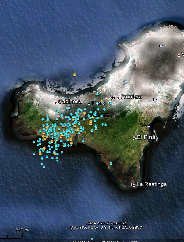
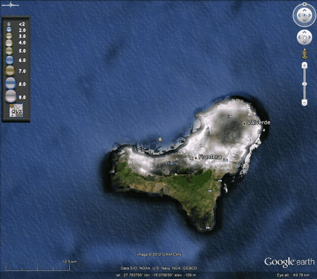
Link to latest activity on El Hierro, looks like things are really moving there.
earthquake-report.com...
earthquake-report.com...
looks like USGS missed one yesterday
5.2 2012/06/27 21:20:58 -15.118 -173.412 19.6 TONGA
4.9 2012/06/27 21:14:03 -15.206 -173.277 15.1 TONGA
5.3 2012/06/27 20:39:18 -15.174 -173.259 23.6 TONGA
earthquake.usgs.gov...
2012 6 27 21 21 4.0 -15.25 -172.75 33.0 5.0 SAMOA ISLANDS REGION
2012 6 27 21 14 8.0 -15.25 -172.75 33.0 5.3 SAMOA ISLANDS REGION
2012 6 27 20 49 4.0 -14.75 -172.75 33.0 5.1 SAMOA ISLANDS
2012 6 27 20 39 20.0 -15.25 -172.75 33.0 5.5 SAMOA ISLANDS REGION
www.ldeo.columbia.edu...
reply to post by AlexanderM
Did you read the article? I am very reasonable and if I am siding with the wrong team I am happy to change. I must say however that just to say my position (actually that of Dr Carayannis) is wrong without offering a shred of evidence to refute my position is not conducive to discussion. Please link to a respected scientific paper that claims there will be 100m tsunamis on the East coast of America and I will be happy to have a read. Incidentally the last figure that I read today coming from the blogosphere was 1/2 mile high tsunami wave for Florida. It just gets better and better!
I am sure that Dr. George Pararas-Carayannis is not wrong, but as I say please link to some material and we will see. Experts do disagree, frequently, so evidence of their dissent would be useful.
Again perhaps you would link to these studies - and don't forget the good Doctor did not say there would not be a tsunami wave. So the evidence that you are taking over the computer model pretty please.
By the way you are aware that the original study was conducted in a closed tank? Not exactly conducive to accurate modelling.
And just with regard to Hawaii and Australia (from the document I linked)
You of course are going to provide the real data of an actual event which makes the computer simulation mentioned above invalid.
Look forward to it.
Final PS: The best evidence for landslide generated tsunamis is actually Alaska. Better go look that one up perhaps.
Forgot to add by the way the study to which you initially referred in connection with a large tsunami was also a computer model.
Here, have a read for yourself.
Puterman, your position on this is disputed, just for your information. Not all the experts agree with what you're saying.
Did you read the article? I am very reasonable and if I am siding with the wrong team I am happy to change. I must say however that just to say my position (actually that of Dr Carayannis) is wrong without offering a shred of evidence to refute my position is not conducive to discussion. Please link to a respected scientific paper that claims there will be 100m tsunamis on the East coast of America and I will be happy to have a read. Incidentally the last figure that I read today coming from the blogosphere was 1/2 mile high tsunami wave for Florida. It just gets better and better!
I am sure that Dr. George Pararas-Carayannis is not wrong, but as I say please link to some material and we will see. Experts do disagree, frequently, so evidence of their dissent would be useful.
The best evidence we have for landslide generated tsunamis is found in Hawaii and Australia, with the wave being generated in Hawaii and hitting Australia. I'll take this evidence over any computer model.
Again perhaps you would link to these studies - and don't forget the good Doctor did not say there would not be a tsunami wave. So the evidence that you are taking over the computer model pretty please.
By the way you are aware that the original study was conducted in a closed tank? Not exactly conducive to accurate modelling.
And just with regard to Hawaii and Australia (from the document I linked)
Computer modeling of such postulated, massive flank failure (Ward, 2001) forecasts that a Pacific-wide, mega-tsunami would be generated. The study concludes that most of the energy of the mega tsunami will be directed toward the southeast, in the direction of Ecuador, but that coastlines as far away as California, Chile, and Australia will be also endangered. Waves as high as 30 m have been forecast for the west coast of North America, and up to 20 m. high for the southwest Pacific.
Unfortunately, media publicity of these estimates has inadvertently created unnecessary public anxiety, by further implying that the threat to coastal communities may be imminent, in both the Atlantic and the Pacific. The subsequent analysis demonstrates that these estimates are incorrect and that the threat of mega tsunami generation from the slope failures of stratovolcanoes has been overstated
You of course are going to provide the real data of an actual event which makes the computer simulation mentioned above invalid.
Look forward to it.
Final PS: The best evidence for landslide generated tsunamis is actually Alaska. Better go look that one up perhaps.
Forgot to add by the way the study to which you initially referred in connection with a large tsunami was also a computer model.
Here, have a read for yourself.
edit on 28/6/2012 by PuterMan because: (no reason given)
Originally posted by muzzy
looks like USGS missed one yesterday
They might have, but I didn't.
Saw it at AFI.IU- like I see a lot of things I don't report anymore. Pretty much anything below 6. I do admire your work, though.
EDIT: the reason USGS did not report is likely that it was a 4.0, not 4.5+
edit on Thu Jun 28th 2012 by TrueAmerican because: (no reason
given)
EDIT 2, nope...lol wrong...it was a 5.1...edit on Thu Jun 28th 2012 by TrueAmerican because: (no reason given)
reply to post by muzzy
Potsdam have 4.7: geofon.gfz-potsdam.de...
This means it may well be below the USGS threshold by the 0.3 for good luck has been taken off.
Don't forget that LDEO is surface wave so you are not comparing like for like.
Italy 2, Germany 1 by the way.
Potsdam have 4.7: geofon.gfz-potsdam.de...
This means it may well be below the USGS threshold by the 0.3 for good luck has been taken off.
Don't forget that LDEO is surface wave so you are not comparing like for like.
Italy 2, Germany 1 by the way.
edit on 28/6/2012 by PuterMan because: (no reason given)
Originally posted by PuterMan
reply to post by AlexanderM
I am of course refering to the work of Young and Bryant, regarding the evidence of the Hawaii landslide and resulting tsunami in Australia 105,000 years ago. Now, this is disputed, but what isn't.
The problem with the computer models that you believe in so certainly, which is ridiculous, is that those models "assume" the slide will behave in a certain manner. And, of course, if that's what you program into the model, that's what you will get out of the model.
With a slide of this size you err on the side of caution, and you don't tell people there will be a 1 meter high tsunami on the east coast of the US because that may mean some will not see the need to seek higher ground. And, if you and your expert are then wrong, and experts are wrong all the time, then many lives are placed in grave danger.
new topics
-
In an Historic First, In N Out Burger Permanently Closes a Location
Mainstream News: 33 minutes ago -
MH370 Again....
Disaster Conspiracies: 1 hours ago -
Are you ready for the return of Jesus Christ? Have you been cleansed by His blood?
Religion, Faith, And Theology: 3 hours ago -
Chronological time line of open source information
History: 4 hours ago -
A man of the people
Diseases and Pandemics: 5 hours ago -
Ramblings on DNA, blood, and Spirit.
Philosophy and Metaphysics: 6 hours ago -
4 plans of US elites to defeat Russia
New World Order: 7 hours ago -
Thousands Of Young Ukrainian Men Trying To Flee The Country To Avoid Conscription And The War
Other Current Events: 11 hours ago
top topics
-
Israeli Missile Strikes in Iran, Explosions in Syria + Iraq
World War Three: 14 hours ago, 17 flags -
Thousands Of Young Ukrainian Men Trying To Flee The Country To Avoid Conscription And The War
Other Current Events: 11 hours ago, 7 flags -
In an Historic First, In N Out Burger Permanently Closes a Location
Mainstream News: 33 minutes ago, 6 flags -
Iran launches Retalliation Strike 4.18.24
World War Three: 14 hours ago, 6 flags -
12 jurors selected in Trump criminal trial
US Political Madness: 13 hours ago, 4 flags -
4 plans of US elites to defeat Russia
New World Order: 7 hours ago, 4 flags -
A man of the people
Diseases and Pandemics: 5 hours ago, 3 flags -
Chronological time line of open source information
History: 4 hours ago, 2 flags -
Are you ready for the return of Jesus Christ? Have you been cleansed by His blood?
Religion, Faith, And Theology: 3 hours ago, 1 flags -
MH370 Again....
Disaster Conspiracies: 1 hours ago, 1 flags
active topics
-
Are you ready for the return of Jesus Christ? Have you been cleansed by His blood?
Religion, Faith, And Theology • 12 • : visitedbythem -
12 jurors selected in Trump criminal trial
US Political Madness • 42 • : Vermilion -
Post A Funny (T&C Friendly) Pic Part IV: The LOL awakens!
General Chit Chat • 7125 • : imitator -
I Guess Cloud Seeding Works
Fragile Earth • 28 • : Degradation33 -
MH370 Again....
Disaster Conspiracies • 1 • : AlexandrosOMegas -
AARO/Dr Kirkpatrick-Caught Lying in UAP report.
Aliens and UFOs • 26 • : baablacksheep1 -
Thousands Of Young Ukrainian Men Trying To Flee The Country To Avoid Conscription And The War
Other Current Events • 21 • : Consvoli -
Not Aliens but a Nazi Occult Inspired and then Science Rendered Design.
Aliens and UFOs • 15 • : anthelion -
-@TH3WH17ERABB17- -Q- ---TIME TO SHOW THE WORLD--- -Part- --44--
Dissecting Disinformation • 540 • : IndieA -
Scarface does Tiny Desk Concert
Music • 8 • : zosimov