It looks like you're using an Ad Blocker.
Please white-list or disable AboveTopSecret.com in your ad-blocking tool.
Thank you.
Some features of ATS will be disabled while you continue to use an ad-blocker.

Quake Watch 2012
page: 166share:
reply to post by zenius
20km from eppi they didn't start here till it started, how long before?? a few seconds half a min?
20km from eppi they didn't start here till it started, how long before?? a few seconds half a min?
reply to post by easybreezy
Only seconds apparently. Must have felt it coming. One friend's dog ran from loung to under bed then it started.
Only seconds apparently. Must have felt it coming. One friend's dog ran from loung to under bed then it started.
It looks like somewhere in SW Oregon just got a decent earthquake
This PB.B031.
Here is a better look-- PB.B033.EHZ
Maybe I'm losing it. I still don't see a listing at PNSN or USGS, but this snapshot of the entire PNW shows something...
ahh, here it is Mag 5.1 offshore Bandon, Oregon
This PB.B031.
Here is a better look-- PB.B033.EHZ
edit on
6/19/2012 by Olivine because: add info
Maybe I'm losing it. I still don't see a listing at PNSN or USGS, but this snapshot of the entire PNW shows something...
ahh, here it is Mag 5.1 offshore Bandon, Oregon
edit on
6/19/2012 by Olivine because: more
2012 June 19 15:56:29 UTC
This event has been reviewed by a seismologist.
Magnitude
6.0 (Preliminary magnitude — update expected within 15 minutes)
Date-Time
Tuesday, June 19, 2012 at 15:56:29 UTC
Tuesday, June 19, 2012 at 06:56:29 AM at epicenter
Location
53.345°N, 171.173°E
Depth
31 km (19.3 miles) set by location program
Region
NEAR ISLANDS, ALEUTIAN ISLANDS, ALASKA
Distances
145 km (90 miles) WNW (293°) from Attu Station, AK
394 km (245 miles) ESE (119°) from Nikol'skoye, Komandorskiye Ostrova, Rus.
834 km (518 miles) E (82°) from Petropavlovsk-Kamchatskiy, Russia
3131 km (1946 miles) NE (41°) from TOKYO, Japan
Location Uncertainty
Error estimate not available
Parameters
NST= 12, Nph= 12, Dmin=208.2 km, Rmss=1.12 sec, Gp=313°,
M-type="moment" magnitude from initial P wave (tsuboi method) (Mi/Mwp), Version=1
Source
West Coast and Alaska Tsunami Warning Center/NOAA/NWS
Event ID
at00m5vga5
USGS INFO
edit on 19-6-2012 by lurksoften because: (no
reason given)
reply to post by lurksoften
Darn that was fast - the alarm only just went off!!
Oh goody! Argument time!
ETA: About that argument. EMSC have now come in at Magnitude mb 6.2
. Now according to the Book Of Magical Incantations by the Great Wizard Muzzy of CamelHot fame that translates to a 6.36 Mw which is a bit less than a 6.36 BMw i
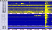
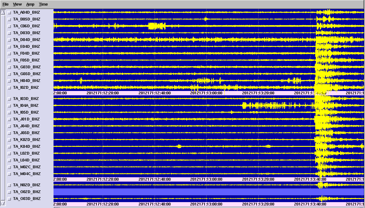
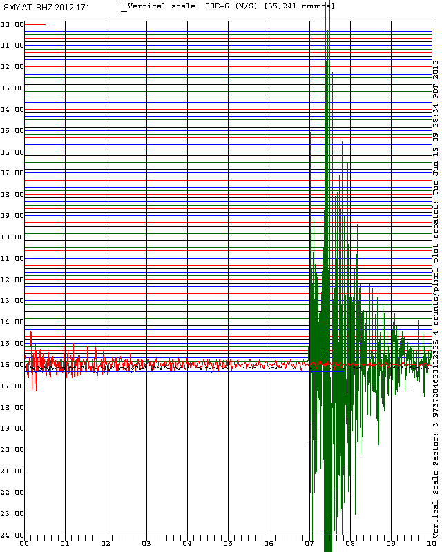
PET.IU.00.BHZ.2012.171 or better one from SMY
USGS Body wave tensor in. Mag 6.0
GFZ Postdam Mag 5.9
GeoAzur Mag 6.0
Darn that was fast - the alarm only just went off!!
Oh goody! Argument time!
Prov,Date/Time UTC,Latitude,Longitude,Magnitude,Depth(Km),Location
emsc,2012-06-19 15:56:31, 53.440, 171.782, 5.8, 2.0, Nr. Isls. Aleutian Isls.
usgs,2012-06-19 15:56:34, 53.391, 171.634, 6.0, 20.9, Nr. Isls.
ETA: About that argument. EMSC have now come in at Magnitude mb 6.2
. Now according to the Book Of Magical Incantations by the Great Wizard Muzzy of CamelHot fame that translates to a 6.36 Mw which is a bit less than a 6.36 BMw i
edit on 19/6/2012 by PuterMan because: (no reason given)
PET.IU.00.BHZ.2012.171 or better one from SMY
USGS Body wave tensor in. Mag 6.0
GFZ Postdam Mag 5.9
GeoAzur Mag 6.0
edit on 19/6/2012 by PuterMan because: (no reason given)
GeoNetRapid- Probably of little interest to most, but some hits on the page over the last few days
I've gone back over the 18thUTC and noted those quakes that were later confirmed on the main database
goo.gl...
The ones that were confirmed have a new "tick" icon
I've used the timing to match them, the Ref No.s are different format anyway.
Will have to reset my main NZ Earthquakes KML popup tags to read seconds by one decimal point, because on the Geonet Rapid there are often 2 entries that are that close (point of a sec)
12/43 confirmed within 24 hrs
reply to post by Olivine
I see USGS has re-reviewed todays earthquake offshore Oregon and decided it was a Mag 5.2 (mb scale).
Professor Ekstrom at LDEO has it at Mag 5.4
It looks to be located on the Blanco Fracture Zone and was probably a strike-slip type event. No worries about the megathrust just yet...
Activity worldwide seems to have picked up a bit.
I see USGS has re-reviewed todays earthquake offshore Oregon and decided it was a Mag 5.2 (mb scale).
Professor Ekstrom at LDEO has it at Mag 5.4
2012 6 19 13 41 4.0 43.50 -127.50 33.0 5.4 OFF COAST OF OREGON
It looks to be located on the Blanco Fracture Zone and was probably a strike-slip type event. No worries about the megathrust just yet...
Activity worldwide seems to have picked up a bit.
NO quakes being reported anywhere around Italy, Turkey, Iraq, Greece region? (on quakes.globalincidentmap.com)
Seems rather unusual, as have never noticed there never being dozens of quakes showing daily for that region.
Maybe a glitch in recordings?
Seems rather unusual, as have never noticed there never being dozens of quakes showing daily for that region.
Maybe a glitch in recordings?
reply to post by SpaceJockey1
Most likely the glitch is in the global incident map website somewhere, as they are still being reported on EMSC. (Lots of them, as usual.)
For example, here's a small chunk of what they reported for June 19:
I find it's better to get the info direct from the primary agencies. That global incident map site is not as reliable.
Mike
Most likely the glitch is in the global incident map website somewhere, as they are still being reported on EMSC. (Lots of them, as usual.)
For example, here's a small chunk of what they reported for June 19:
2012-06-19 23:56:44.05hr 31min ago44.84 N 11.08 E 92.0 NORTHERN ITALY
2012-06-19 23:43:04.05hr 45min ago39.45 N 38.79 E 73.0 EASTERN TURKEY
2012-06-19 23:33:07.85hr 55min ago37.01 N 28.60 E 42.4 WESTERN TURKEY
2012-06-19 23:11:34.06hr 16min ago44.91 N 11.14 E 362.7 NORTHERN ITALY
2012-06-19 23:02:23.06hr 26min ago44.84 N 11.21 E 202.6 NORTHERN ITALY
2012-06-19 22:45:03.26hr 43min ago36.42 N 28.95 E 162.5 DODECANESE ISLANDS, GREECE
2012-06-19 22:16:44.07hr 11min ago44.79 N 11.01 E 102.1 NORTHERN ITALY
2012-06-19 22:06:29.07hr 22min ago44.73 N 11.08 E 232.2 NORTHERN ITALY
2012-06-19 22:05:44.07hr 22min ago41.11 N 6.81 W 153.9 PORTUGAL
2012-06-19 21:56:31.07hr 32min ago44.91 N 11.07 E 32.0 NORTHERN ITALY
2012-06-19 21:53:49.57hr 34min ago36.34 N 29.25 E 102.6 WESTERN TURKEY F
2012-06-19 21:48:30.07hr 40min ago44.93 N 11.04 E 103.2 NORTHERN ITALY
2012-06-19 21:42:13.07hr 46min ago44.89 N 11.15 E 22.7 NORTHERN ITALY
2012-06-19 21:28:52.07hr 59min ago44.82 N 10.93 E 62.0 NORTHERN ITALY
2012-06-19 21:17:09.78hr 11min ago38.64 N 43.08 E 82.7 EASTERN TURKEY
2012-06-19 21:02:28.08hr 26min ago36.36 N 8.17 W 102.5 WEST OF GIBRALTAR
2012-06-19 20:28:38.08hr 59min ago44.91 N 11.07 E 82.3 NORTHERN ITALY
2012-06-19 20:23:37.39hr 04min ago40.12 N 36.04 E 52.8 CENTRAL TURKEY
2012-06-19 20:02:51.09hr 25min ago39.26 N 41.95 E 73.1 EASTERN TURKEY
2012-06-19 19:36:22.89hr 52min ago39.10 N 29.15 E 72.5 WESTERN TURKEY
2012-06-19 19:00:31.010hr 28min ago38.45 N 39.07 E 103.0 EASTERN TURKEY
2012-06-19 18:28:18.111hr 00min ago49.97 N 0.48 E 22.9 FRANCE
2012-06-19 18:24:21.911hr 04min ago44.48 N 17.58 E 22.5 BOSNIA AND HERZEGOVINA 2012-06-19 18:23:00.211hr 05min ago40.77 N 27.52 E 82.5 WESTERN TURKEY
2012-06-19 18:05:01.611hr 23min ago39.03 N 29.15 E 142.6 WESTERN TURKEY
2012-06-19 17:53:25.011hr 35min ago44.85 N 11.25 E 152.0 NORTHERN ITALY
2012-06-19 17:47:06.811hr 41min ago37.21 N 31.71 E 52.5 WESTERN TURKEY
2012-06-19 17:30:06.811hr 58min ago40.54 N 21.67 E 112.1 GREECE
2012-06-19 16:13:43.037.28 N 42.57 E 13.2 TURKEY-SYRIA-IRAQ BORDER REGION
I find it's better to get the info direct from the primary agencies. That global incident map site is not as reliable.
Mike
edit on 20/6/12 by JustMike because: added list of some quakes from EMSC
Yeah could be something wrong with the EMSC feed.
A couple of hours ago I went to the EMSC page I have saved on Speed Dial which is set to 5+ magnitude, but it was showing 4+ on the first page. I flicked the "page 2" tab to find some stuff for the 18th and it went straight to 6th June. Couldn't get it to load anything in between so I gave up and used Geofon instead.
A lot of the EMSC feeds come from Geofon anyway.
One reason I don't use EMSC much, is when you are looking at NOA (Greece) and KOERI (Turkey) on a regular basis and then compare what they have to what EMSC have, hardly anything matches time or magnitude wise.
Try comparing the NOA to KOERI data for the Eastern Aegean Sea side is even worse
reply to post by muzzy
Hi Muzzy,
I wonder if this is a regional problem with the feed? For example, I've had no problems accessing the EMSC pages, but I'm in Europe so I suppose the routing is a bit more direct. (I could be supposing wrongly, of course. Do people geographically closer usually get a more "direct" line of feed?)
Regarding what you said about your EMSC page display, my 5+ magnitude (worldwide) display shows 50 events per page and so page 1 currently goes back as far as some of the quakes from June 7th. As yours is so different -- or was at that time you mentioned -- it strongly suggests feed problems.
In any case I take your point about discrepancies between the various reporting sites. I suppose it ultimately comes down to whom we individually consider the most accurate for a given region.
Best regards,
Mike
edit on 20/6/12 by JustMike because: I added a bit. I do that sometimes.
reply to post by JustMike
Seems to be working OK this morning (NZST)
What you described re the first page.
Not sure what happened there, seems they substituted Mag4+ page for Mag 5+ page, so there were more entries of course, taking it into more than the first page.
Seems to be working OK this morning (NZST)
What you described re the first page.
Not sure what happened there, seems they substituted Mag4+ page for Mag 5+ page, so there were more entries of course, taking it into more than the first page.
~nevermind, read the wrong numbers~
edit on 20-6-2012 by muzzy because: (no reason given)
Date-Time [UTC]: Thursday, 21th June 2012 at
11:11 AM Local Date/Time:
Thursday, June 21, 2012 at 11:11 in the morning at
Coordinate: 66° 51.600, 18° 16.200
Depth: 1 km (0.62 miles)
Hypocentrum: Shallow depth
Class: Minor
Region: Europe
Country: Iceland
Location: 38.23 km (23.76 miles) SE of
Midgardar, Iceland
"Midgard" lol at 11:11 ohh my this cant be good lol
10 minutes ago
and earlier today
Big traces on SNZO
earthquake.usgs.gov...
getting hammered from each end
LDEO have a different opinion on the S of Kermy ones
kind of hard to tell where on the 00 line that 2nd one starts, because the 1st one is still doing its thing, according to the TTCalculator the Sn wave hit SNZO at 00:07:22, not sure what the "n" stands for, quakes from this area never have clean P or S wave results, often I use the PcP wave if it is a smaller one.
Judging by the size of the signals after 00:07:22, I'd say LDEO are right, thats way too big for a lousy 4.8
F-E Region: Macquarie Island Region
Time: 2012-06-22 04:31:18.7 UTC
Magnitude: 5.9
Epicenter: 158.79°E 54.30°S
Depth: 10 km
Status: A - automatic
geofon.gfz-potsdam.de...
and earlier today
5.7 2012/06/22 02:20:09 -32.795 -178.562 23.6 SOUTH OF THE KERMADEC ISLANDS
4.8 2012/06/22 00:03:13 -32.999 -179.833 35.1 SOUTH OF THE KERMADEC ISLANDS
5.2 2012/06/21 23:52:57 -32.889 -178.637 37.4 SOUTH OF THE KERMADEC ISLANDS
earthquake.usgs.gov...
Big traces on SNZO
earthquake.usgs.gov...
getting hammered from each end
edit on 21-6-2012 by muzzy because: (no reason given)
LDEO have a different opinion on the S of Kermy ones
2012 6 22 2 20 8.0 -33.25 -178.25 33.0 5.6 SOUTH OF KERMADEC ISLANDS
2012 6 22 0 3 4.0 -32.75 -178.25 33.0 5.3 SOUTH OF KERMADEC ISLANDS
2012 6 21 23 52 56.0 -32.75 -178.25 33.0 5.4 SOUTH OF KERMADEC ISLANDS
www.ldeo.columbia.edu...
kind of hard to tell where on the 00 line that 2nd one starts, because the 1st one is still doing its thing, according to the TTCalculator the Sn wave hit SNZO at 00:07:22, not sure what the "n" stands for, quakes from this area never have clean P or S wave results, often I use the PcP wave if it is a smaller one.
Judging by the size of the signals after 00:07:22, I'd say LDEO are right, thats way too big for a lousy 4.8
edit on 22-6-2012 by muzzy
because: (no reason given)
reply to post by BobAthome
I get your point but why not Midgard since Iceland is more of less where the name came from?
Sicklypedia
I am more interested in your source however as I don't recognise the layout and terminology.
I get your point but why not Midgard since Iceland is more of less where the name came from?
Midgard (an anglicised form of Old Norse Miðgarðr; Old English Middangeard, Old High German Mittilagart, literally "middle enclosure") is the name for the world (in the sense of oikoumene) inhabited by and known to humans in early Germanic cosmology, and specifically one of the Nine Worlds and in Norse mythology.
Sicklypedia
I am more interested in your source however as I don't recognise the layout and terminology.
reply to post by PuterMan
it was rsoe edis
but here is a different site,
www.emsc-csem.org...
its
Magnitude ML 3.3
Region ICELAND REGION
Date time 2012-06-21 11:11:06.0 UTC
Location 67.07 N ; 18.20 W
Depth 1 km
so its real,, 3.9 orig,, now 3.3 i see,, and gone into history
it was rsoe edis
but here is a different site,
www.emsc-csem.org...
its
Magnitude ML 3.3
Region ICELAND REGION
Date time 2012-06-21 11:11:06.0 UTC
Location 67.07 N ; 18.20 W
Depth 1 km
so its real,, 3.9 orig,, now 3.3 i see,, and gone into history
I don't agree with the magnitudes (too low) but for once USGS may have it right regarding the order
compared with Geofon
if you look on the SNZO graph on the 12:00 line the 2nd one (timewise) is quite obviously smaller than the 1st, even given the 2nd on is out on the Pacific Plate and further away than in the Kerm subduction zone where all the other quakes were.
Busy 12 hours, I crashed my image editing programme 5 times marking up the graph, too many colours
2 still unidentified, Southern Ocean judging by the shape of the wiggles
I used Sn wave arrival times for all the Kermadec ones, to be consistant, that wave corresponds with each trace quite well. No P waves shown on LISS SNZO, too close maybe?
There was a similar swarm back on 13/02/2102, lower magnitudes there, but you can still compare what a 5.0, or 4.8 looks like, thats why I say USGS's mags are too low yesterday
Macquarie at 5.9 looks about right compared with MacIs 5.8 on 09/02/2012
4.8 2012/06/22 12:30:19 -30.363 -175.593 9.6 KERMADEC ISLANDS REGION
4.9 2012/06/22 12:12:50 -33.060 -178.246 14.6 SOUTH OF THE KERMADEC ISLANDS
compared with Geofon
5.2 2012-06-22 12:30:19 30.63°S 175.47°W 10 M Kermadec Islands Region
5.0 2012-06-22 12:12:56 33.16°S 178.64°W 31 M South of Kermadec Islands
if you look on the SNZO graph on the 12:00 line the 2nd one (timewise) is quite obviously smaller than the 1st, even given the 2nd on is out on the Pacific Plate and further away than in the Kerm subduction zone where all the other quakes were.
Busy 12 hours, I crashed my image editing programme 5 times marking up the graph, too many colours
2 still unidentified, Southern Ocean judging by the shape of the wiggles
I used Sn wave arrival times for all the Kermadec ones, to be consistant, that wave corresponds with each trace quite well. No P waves shown on LISS SNZO, too close maybe?
There was a similar swarm back on 13/02/2102, lower magnitudes there, but you can still compare what a 5.0, or 4.8 looks like, thats why I say USGS's mags are too low yesterday
Macquarie at 5.9 looks about right compared with MacIs 5.8 on 09/02/2012
new topics
-
Former NYT Reporter Attacks Scientists For Misleading Him Over COVID Lab-Leak Theory
Education and Media: 1 hours ago -
Why did Phizer team with nanobot maker
Medical Issues & Conspiracies: 1 hours ago -
Pro Hamas protesters at Columbia claim hit with chemical spray
World War Three: 1 hours ago -
Elites disapearing
Political Conspiracies: 3 hours ago -
A Personal Cigar UFO/UAP Video footage I have held onto and will release it here and now.
Aliens and UFOs: 3 hours ago -
Go Woke, Go Broke--Forbes Confirms Disney Has Lost Money On Star Wars
Movies: 5 hours ago -
Freddie Mercury
Paranormal Studies: 6 hours ago -
Nirvana - Immigrant Song
Music: 10 hours ago -
British TV Presenter Refuses To Use Guest's Preferred Pronouns
Education and Media: 11 hours ago
top topics
-
British TV Presenter Refuses To Use Guest's Preferred Pronouns
Education and Media: 11 hours ago, 16 flags -
Go Woke, Go Broke--Forbes Confirms Disney Has Lost Money On Star Wars
Movies: 5 hours ago, 12 flags -
Pro Hamas protesters at Columbia claim hit with chemical spray
World War Three: 1 hours ago, 9 flags -
Trump To Hold Dinner with President of Poland At Trump Tower Tonight
2024 Elections: 14 hours ago, 8 flags -
Tucker Carlson interviews Christian pastor from Bethlehem.
Middle East Issues: 13 hours ago, 7 flags -
Elites disapearing
Political Conspiracies: 3 hours ago, 7 flags -
A family from Kansas with six children moved to the Moscow region
Other Current Events: 17 hours ago, 6 flags -
Freddie Mercury
Paranormal Studies: 6 hours ago, 6 flags -
A Personal Cigar UFO/UAP Video footage I have held onto and will release it here and now.
Aliens and UFOs: 3 hours ago, 5 flags -
Nirvana - Immigrant Song
Music: 10 hours ago, 4 flags
active topics
-
Max Loughan Boy Genius Or Something More?
Science & Technology • 67 • : fluctz -
British TV Presenter Refuses To Use Guest's Preferred Pronouns
Education and Media • 47 • : ImagoDei -
Trump To Hold Dinner with President of Poland At Trump Tower Tonight
2024 Elections • 36 • : ImagoDei -
Elites disapearing
Political Conspiracies • 14 • : AwakeNotWoke -
Freddie Mercury
Paranormal Studies • 1 • : AwakeNotWoke -
Why did Phizer team with nanobot maker
Medical Issues & Conspiracies • 1 • : AwakeNotWoke -
Pro Hamas protesters at Columbia claim hit with chemical spray
World War Three • 6 • : DBCowboy -
Former NYT Reporter Attacks Scientists For Misleading Him Over COVID Lab-Leak Theory
Education and Media • 1 • : Dandandat3 -
Gold and silver prices....woo hoo
History • 75 • : SchrodingersRat -
-@TH3WH17ERABB17- -Q- ---TIME TO SHOW THE WORLD--- -Part- --44--
Dissecting Disinformation • 512 • : cherokeetroy