It looks like you're using an Ad Blocker.
Please white-list or disable AboveTopSecret.com in your ad-blocking tool.
Thank you.
Some features of ATS will be disabled while you continue to use an ad-blocker.

Quake Watch 2012
page: 164share:
reply to post by JohnVidale
No sorry, have to take issue with you on that ( ). If they were to cut it in half I still think that the incision would only travel around the circumference and thus the resulting magnitude would only be in the region of the theoretical 10.5+ as the power needed to actually cut it in half would be impossible.
May I also point out that 10 Mag 9.5 daisy chained would in fact be approximately a Mag 10.2 in terms of energy release @ ~112,201,845,430,189,000 kilojoules of energy( and thus possible if extremely unlikely) and not a mag 10.5 which would be ~32 the output of a 9.5 at ~359,045,905,376,606,000 kilojoules, but 10 times the amplitude or strength if you prefer. 10 x 1000km is only 10,000 km and thus well within the capability of the earth to sustain being 24,901 miles (40,075 km) approximately in circumference.
Now seeing as we are only talking about a disagreement of 0.5 of a magnitude, and you say geologists really don't take any notice of 0.5 of a magnitude. you could say we are talking about the same thing.
Now if the aliens were to attack from two different directions at once..................
Or that space aliens could rip the planet in half at the speed of light - that must be worth an M14 or 15 at least.
No sorry, have to take issue with you on that ( ). If they were to cut it in half I still think that the incision would only travel around the circumference and thus the resulting magnitude would only be in the region of the theoretical 10.5+ as the power needed to actually cut it in half would be impossible.
May I also point out that 10 Mag 9.5 daisy chained would in fact be approximately a Mag 10.2 in terms of energy release @ ~112,201,845,430,189,000 kilojoules of energy( and thus possible if extremely unlikely) and not a mag 10.5 which would be ~32 the output of a 9.5 at ~359,045,905,376,606,000 kilojoules, but 10 times the amplitude or strength if you prefer. 10 x 1000km is only 10,000 km and thus well within the capability of the earth to sustain being 24,901 miles (40,075 km) approximately in circumference.
Now seeing as we are only talking about a disagreement of 0.5 of a magnitude, and you say geologists really don't take any notice of 0.5 of a magnitude. you could say we are talking about the same thing.
Now if the aliens were to attack from two different directions at once..................
edit on 17/6/2012 by PuterMan because: (no reason given)
3 new large 6.0-ish quakes in japan.
ETA: is it noteworthy that at apparently at the same exact time there was a small quake in CA along the same parallel? (more or less)
ETA: is it noteworthy that at apparently at the same exact time there was a small quake in CA along the same parallel? (more or less)
edit on 17-6-2012 by stanguilles7 because: (no reason given)
Potsdam have it as a 6.2 Mw
geofon.gfz-potsdam.de...
Russians not showing it yet.
EMSC have come up to 6.4 Mw as well.
GeoAzur have 6.3 geoazur.oca.eu...
geofon.gfz-potsdam.de...
Russians not showing it yet.
EMSC have come up to 6.4 Mw as well.
GeoAzur have 6.3 geoazur.oca.eu...
edit on 17/6/2012 by PuterMan because: (no reason given)
reply to post by stanguilles7
Sorry but where are the three quakes? I can only see one.
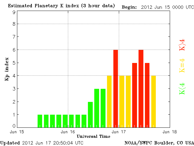
We are also in a solar storm
Sorry but where are the three quakes? I can only see one.
Prov,Date/Time UTC,Latitude,Longitude,Magnitude,Depth(Km),Location
emsc,2012-06-17 18:49:11, 1.264, 126.901, 4.8, 80.0, Molucca Sea
emsc,2012-06-17 18:52:09, 23.697, 121.521, 4.1, 5.0, Taiwan
usgs,2012-06-17 19:20:43, 40.569, 21.629, 4.6, 14.2, Greece
emsc,2012-06-17 19:20:43, 40.525, 21.581, 4.2, 17.0, Greece
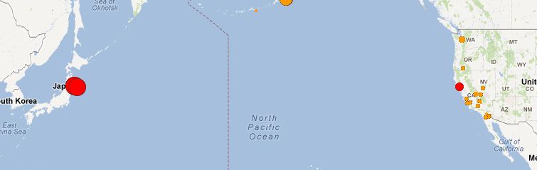
jmo,2012-06-17 20:32:00, 38.900, 142.100, 6.1, 40.0, Miyagi-Ken Oki
usgs,2012-06-17 20:32:20, 38.893, 141.945, 6.4, 31.8, Nr. E. Coast Of Honshu. Japan
emsc,2012-06-17 20:32:23, 38.965, 141.820, 6.4, 60.0, Nr. E. Coast Of Honshu Japan
We are also in a solar storm
edit on 17/6/2012 by PuterMan because: (no reason given)
reply to post by PuterMan
Hard to argue with that logic. However, the daisy chain should account for moment, not energy or amplitude. Moment is simply proportionate to fault area times slip.
Hard to argue with that logic. However, the daisy chain should account for moment, not energy or amplitude. Moment is simply proportionate to fault area times slip.
reply to post by JohnVidale
Yes true, I was considering the energy aspect but you are correct in terms of moment your calculation would be right.
As a matter of interest John is there actually any sort of guide anywhere to fault lengths and rupture areas? I found one once but seem to have lost it again.
Yes true, I was considering the energy aspect but you are correct in terms of moment your calculation would be right.
As a matter of interest John is there actually any sort of guide anywhere to fault lengths and rupture areas? I found one once but seem to have lost it again.
Originally posted by PuterMan
reply to post by stanguilles7
Sorry but where are the three quakes? I can only see one.
I was watching globalincidentmaps, not quakewatch.
They still show three if you zoom in close enough. quakes.globalincidentmap.com...
Perhaps I'm reading it wrong.
We are also in a solar storm
My youngest is teething.
Are we all ready to do the hippy hippy shake? They are ping ponging across the border now.
Hmmm...Hopefully this isn't where the next 7 pops up.
E.T.A.
Magnitude
2.2
Date-Time
Sunday, June 17, 2012 at 06:38:53 UTC
Sunday, June 17, 2012 at 01:38:53 AM at epicenter
Time of Earthquake in other Time Zones
Location
36.482°N, 89.553°W
Depth
9 km (5.6 miles)
Region
SOUTHEASTERN MISSOURI
Distances
6 km (4 miles) SE (128°) from Marston, MO
10 km (6 miles) SSE (157°) from Howardville, MO
12 km (7 miles) S (188°) from New Madrid, MO
44 km (28 miles) S (176°) from Sikeston, MO
156 km (97 miles) NNE (14°) from Memphis, TN
246 km (153 miles) SSE (166°) from St. Louis, MO
Location Uncertainty
horizontal +/- 0.4 km (0.2 miles); depth +/- 0.9 km (0.6 miles)
Parameters
NST= 23, Nph= 41, Dmin=6 km, Rmss=0.06 sec, Gp= 54°,
M-type=duration magnitude (Md), Version=A
Source
Cooperative New Madrid Seismic Network
Event ID
nm061712b
edit on 17-6-2012 by Doodle19815 because: (no reason given)
reply to post by PuterMan
You might try clicking the links on this page to see some slip distributions:
www.seismo.ethz.ch...
You might try clicking the links on this page to see some slip distributions:
www.seismo.ethz.ch...
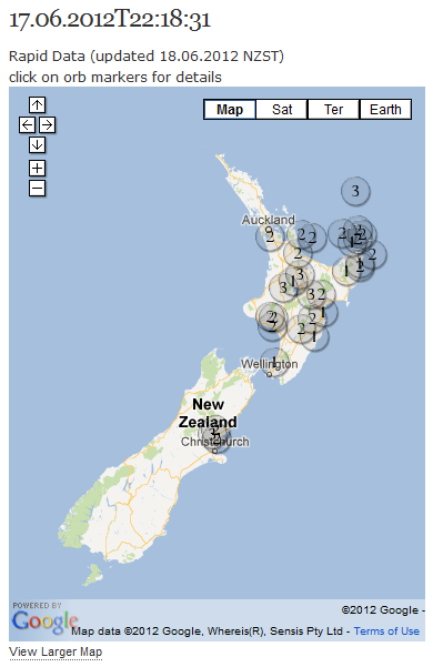
Geonet has been really slow loading data to the database the last 3 days, so to keep myself amused I went ahead and started mapping out the Rapid
data.
When I get time I'll go back over it and see if any of them were for real (they are automated)
I tried using the KML file that you can download, but the icons suck and I couldn't be bothered changing them one by one, so ran the KML file through a GPS convertor program to get it back to Excel CSV file so I could edit it.
automatic new zealand earthquakes
comes with new see through icons but hopeless on satellite and GE maps
sample
I also clicked the special Onswipe iPad Settings option for this blog, not sure what difference it makes though
edit on 18-6-2012 by muzzy because: clicked the wrong reply button, not a reply to anyone, must be getting cabin fever, been raining all
day
reply to post by stanguilles7
Yes I had a feeling it was GIR. Just remember that they are showing several feeds - in this case probably the same as I use JMA, USGS and EMSC so you need to understand and remember that. Not three quakes but one quake from three different sources..
I don't know if they do but you should be able to turn off all feeds except one to see what is happening.
reply to post by JohnVidale
Thanks. Will take a look later.
They still show three if you zoom in close enough
Yes I had a feeling it was GIR. Just remember that they are showing several feeds - in this case probably the same as I use JMA, USGS and EMSC so you need to understand and remember that. Not three quakes but one quake from three different sources..
I don't know if they do but you should be able to turn off all feeds except one to see what is happening.
reply to post by JohnVidale
Thanks. Will take a look later.
reply to post by JohnVidale
Thank you also for that link.
I decided to not get involved in the discussion of how big a quake would be generated if aliens tried to split the planet in half; this was partly because I saw Star Wars and thought it wouldn't be something we'd wind up discussing if they ever do it anyway, but moreso because I wouldn't stand much chance against someone who won a chess tournament in Ms Bartelotti's 4rd-grad [sic] class...
...which in my humble opinion is even more impressive than the BSs in Physics and Geology you picked up at some place called "Yale" or that Caltech (is that an oil company? ) PhD in seismology.
But yeah, I appreciate your sense of humour. In fact, would love to have that little cartoon from your "humor" page on the thread here if permission is not an issue. Can do?
Meanwhile, John, I'm wondering if you might have a word to someone in USGS about their fabulous new version of the Real-time Earthquake Map.
The problem I have is this:
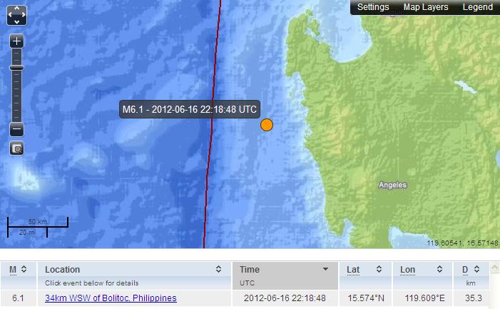
Please scroll to the right of the image. I set my mouse pointer thing as near as possible to the middle of the orange dot for that quake, and in the bottom RH corner of the image we see "119.60541, 15.57148".
Pretty impressive accuracy, that. (Theirs, not mine with the mouse thing.) And below it in the data under the map, there's the actual co-ords for the quake: 15.574N, 119.609E.
Question: why does the map show the coordinates reversed?
Okay, in this case the error is apparent as 119 degrees N or S is impossible, but when we get to lower numbers it can get a tad confusing. But confusing or not, if they're going to display such data on a map then it's better if it's unequivocally correct.
So, if you could let them know (in case they haven't noticed yet), it would be appreciated. I expect they'll listen to you.
Best regards,
Mike
Thank you also for that link.
I decided to not get involved in the discussion of how big a quake would be generated if aliens tried to split the planet in half; this was partly because I saw Star Wars and thought it wouldn't be something we'd wind up discussing if they ever do it anyway, but moreso because I wouldn't stand much chance against someone who won a chess tournament in Ms Bartelotti's 4rd-grad [sic] class...
...which in my humble opinion is even more impressive than the BSs in Physics and Geology you picked up at some place called "Yale" or that Caltech (is that an oil company? ) PhD in seismology.
But yeah, I appreciate your sense of humour. In fact, would love to have that little cartoon from your "humor" page on the thread here if permission is not an issue. Can do?
Meanwhile, John, I'm wondering if you might have a word to someone in USGS about their fabulous new version of the Real-time Earthquake Map.
The problem I have is this:
Please scroll to the right of the image. I set my mouse pointer thing as near as possible to the middle of the orange dot for that quake, and in the bottom RH corner of the image we see "119.60541, 15.57148".
Pretty impressive accuracy, that. (Theirs, not mine with the mouse thing.) And below it in the data under the map, there's the actual co-ords for the quake: 15.574N, 119.609E.
Question: why does the map show the coordinates reversed?
Okay, in this case the error is apparent as 119 degrees N or S is impossible, but when we get to lower numbers it can get a tad confusing. But confusing or not, if they're going to display such data on a map then it's better if it's unequivocally correct.
So, if you could let them know (in case they haven't noticed yet), it would be appreciated. I expect they'll listen to you.
Best regards,
Mike
edit on 18/6/12 by JustMike because: I maded it even eruditer then it wuz.
reply to post by stanguilles7
Hello Stanguilles7,
I didn't recognize you with your new avatar. Nice one, that.
Down to business: as Puterman said, the Global Incidents map has this tendency to show multiple locations for what are actually single events. That can get confusing and in some cases is even misleading, so it might be better to use other sources, like USGS and EMSC for example.
OT for a moment:
Okay, back OT:
I see that in this post from about 36 hours ago, you responded to a comment by another poster about a quake at 33km not being [all] that deep by asking
Now, that's a pretty fair question, as on the surface of it (pun ), 33 km sounds pretty deep. But with quakes, we have to take into account what range of depths are known and so we use relative terms. It's not uncommon to see quakes more than 100 km deep (~60 miles) and for example this one in Argentina on June 14 was at a depth of 532.1 km (330.6 miles)! Now, that qualifies as deep!
I'm sure that even here on this board there are likely some differences of opinion as to how deep is really deep, but most would probably agree that 33km isn't all that deep for a quake. Relatively speaking.
Best regards,
Mike
Hello Stanguilles7,
I didn't recognize you with your new avatar. Nice one, that.
Down to business: as Puterman said, the Global Incidents map has this tendency to show multiple locations for what are actually single events. That can get confusing and in some cases is even misleading, so it might be better to use other sources, like USGS and EMSC for example.
OT for a moment:
You have my sympathies and I'm sure that goes for all us who've had kids. As this is your youngest, though, I guess you've learned most of the tricks to help her/him feel as comfortable as possible.
My youngest is teething.
Okay, back OT:
I see that in this post from about 36 hours ago, you responded to a comment by another poster about a quake at 33km not being [all] that deep by asking
since when is 33km not deep?
Now, that's a pretty fair question, as on the surface of it (pun ), 33 km sounds pretty deep. But with quakes, we have to take into account what range of depths are known and so we use relative terms. It's not uncommon to see quakes more than 100 km deep (~60 miles) and for example this one in Argentina on June 14 was at a depth of 532.1 km (330.6 miles)! Now, that qualifies as deep!
I'm sure that even here on this board there are likely some differences of opinion as to how deep is really deep, but most would probably agree that 33km isn't all that deep for a quake. Relatively speaking.
Best regards,
Mike
edit on 18/6/12 by JustMike because: There was a minor coding error that -- oh, skip it. Nobody reads these things anyway!
Thanks Mike.
I do!
Originally posted by JustMike
edit on 18/6/12 by JustMike because: There was a minor coding error that -- oh, skip it. Nobody reads these things anyway!
I do!
reply to post by JustMike
Your suggestion is good, but they do not listen to us, either. Notice that no regional network exists on their page except as a source for the information that only they provide.
Your suggestion is good, but they do not listen to us, either. Notice that no regional network exists on their page except as a source for the information that only they provide.
reply to post by JustMike
and "grade" was spelled right, not as "grad". Maybe you truncated the end of the line.
Damn iWeb, I have to move that site by the end of the month, as Apple is shutting it down. I invested hours loading all that stuff, and it's fine with me to use whatever you find there, although of course, I'm not guaranteeing than I own all of it.
reply to post by muzzy
So far so good
Not sure what would happen if there were more than 30 quakes within the space of time between when I download the KML file though, probably miss some.
Interesting though, I found 3 more quakes from going through the Regions "Felt" ones, that I missed because of a lapse of attention to downloading the KML file, one near Codfish Island off Stewart Is, probably a dud as they hardly ever get quakes there showing on the main database, however its shown on a "Felt" list for Southland. Not sure how it works, if its on the Rapid Felt list, why isn't it on the Recent Quakes page
edit on 18-6-2012 by muzzy because: (no reason given)
reply to post by JohnVidale
Thanks, John. Sorry about my error. I actually did things the old-fashioned way and typed out that line instead of copying and pasting, hence my typo with "grad" versus the correct "grade". I should have had my glasses on. (Not kidding. I wasn't wearing them at the time.)
My [sic] notation was actually for the "4rd" (as in "4rd-grade class"). I was taught to use "4th" as in 1st, 2nd, 3rd, 4th, 5th (etc etc), but I guess in the US it's different. I hadn't noticed this before so my apologies for that. Still gives the same concept, though.
Anyway, on to the serious stuff. On a website page for a noted seismologist (coincidentally also named John Vidale), there is this little gem that I'd like to share with members here as it demonstrates the gravity of what we are dealing with in terms of quakes and releasing data:
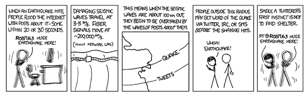
Maybe in future we could have special waveform analysis applications for tweet waves? I mean, sometimes their impact is more devastating on the populace than the actual quakes...
Mike
Thanks, John. Sorry about my error. I actually did things the old-fashioned way and typed out that line instead of copying and pasting, hence my typo with "grad" versus the correct "grade". I should have had my glasses on. (Not kidding. I wasn't wearing them at the time.)
My [sic] notation was actually for the "4rd" (as in "4rd-grade class"). I was taught to use "4th" as in 1st, 2nd, 3rd, 4th, 5th (etc etc), but I guess in the US it's different. I hadn't noticed this before so my apologies for that. Still gives the same concept, though.
Anyway, on to the serious stuff. On a website page for a noted seismologist (coincidentally also named John Vidale), there is this little gem that I'd like to share with members here as it demonstrates the gravity of what we are dealing with in terms of quakes and releasing data:
Maybe in future we could have special waveform analysis applications for tweet waves? I mean, sometimes their impact is more devastating on the populace than the actual quakes...
Mike
edit on 18/6/12 by JustMike because: ˙pɹɐoqʎǝʞ ʎɯ ɥʇıʍ ƃuoɹʍ ƃuıɥʇǝɯos sı ǝɹǝɥʇ
reply to post by JustMike
My mistake then, 4rd is the notable glitch. And Paul Earle at NEIC has tracked earthquakes with tweets, but in fact the tweets now spread faster than the P waves - apparently people watch TV and tweeted about the Virginia earthquake within seconds from across the country.
My mistake then, 4rd is the notable glitch. And Paul Earle at NEIC has tracked earthquakes with tweets, but in fact the tweets now spread faster than the P waves - apparently people watch TV and tweeted about the Virginia earthquake within seconds from across the country.
reply to post by JohnVidale
I was actually not kidding about that 4rd/4th thing. It's only a contraction and it does the job so I thought maybe it was the way things were going. I know the US has been trending towards simplifying the language, after all.
My apologies to our OP and others for topic drift.
On the serious stuff again -- and this time for real -- this matter of tweets travelling faster than P waves is actually highly significant, because in fact, such a social network medium could serve as a sort of early-warning system in some cases. What I mean is that it could be developed further and employed for people's benefit.
Use the public in a positive way. It's working for news reporting, and while it's true that a lot of garbage gets reported, it's also harder for officials to "hide and deny" as easily as they used to and in some cases that's beneficial. I can see benefits in the "tweet wave" phenomenon.
Best regards,
Mike
edit on 18/6/12 by JustMike because: Why does everything have to happen for a reason?
new topics
-
Supreme Court Oral Arguments 4.25.2024 - Are PRESIDENTS IMMUNE From Later Being Prosecuted.
Above Politics: 35 minutes ago -
Krystalnacht on today's most elite Universities?
Social Issues and Civil Unrest: 44 minutes ago -
Chris Christie Wishes Death Upon Trump and Ramaswamy
Politicians & People: 1 hours ago -
University of Texas Instantly Shuts Down Anti Israel Protests
Education and Media: 3 hours ago -
Any one suspicious of fever promotions events, major investor Goldman Sachs card only.
The Gray Area: 5 hours ago -
God's Righteousness is Greater than Our Wrath
Religion, Faith, And Theology: 9 hours ago
top topics
-
VP's Secret Service agent brawls with other agents at Andrews
Mainstream News: 14 hours ago, 11 flags -
Nearly 70% Of Americans Want Talks To End War In Ukraine
Political Issues: 15 hours ago, 5 flags -
Sunak spinning the sickness figures
Other Current Events: 15 hours ago, 5 flags -
Electrical tricks for saving money
Education and Media: 13 hours ago, 4 flags -
Late Night with the Devil - a really good unusual modern horror film.
Movies: 17 hours ago, 3 flags -
Krystalnacht on today's most elite Universities?
Social Issues and Civil Unrest: 44 minutes ago, 3 flags -
University of Texas Instantly Shuts Down Anti Israel Protests
Education and Media: 3 hours ago, 2 flags -
Any one suspicious of fever promotions events, major investor Goldman Sachs card only.
The Gray Area: 5 hours ago, 2 flags -
Supreme Court Oral Arguments 4.25.2024 - Are PRESIDENTS IMMUNE From Later Being Prosecuted.
Above Politics: 35 minutes ago, 2 flags -
Chris Christie Wishes Death Upon Trump and Ramaswamy
Politicians & People: 1 hours ago, 0 flags
active topics
-
University of Texas Instantly Shuts Down Anti Israel Protests
Education and Media • 57 • : Threadbarer -
The Reality of the Laser
Military Projects • 48 • : 5thHead -
Nearly 70% Of Americans Want Talks To End War In Ukraine
Political Issues • 69 • : SchrodingersRat -
Supreme Court Oral Arguments 4.25.2024 - Are PRESIDENTS IMMUNE From Later Being Prosecuted.
Above Politics • 1 • : network dude -
Candidate TRUMP Now Has Crazy Judge JUAN MERCHAN After Him - The Stormy Daniels Hush-Money Case.
Political Conspiracies • 744 • : Threadbarer -
Truth Social goes public, be careful not to lose your money
Mainstream News • 129 • : matafuchs -
Krystalnacht on today's most elite Universities?
Social Issues and Civil Unrest • 2 • : marg6043 -
Remember These Attacks When President Trump 2.0 Retribution-Justice Commences.
2024 Elections • 56 • : WeMustCare -
British TV Presenter Refuses To Use Guest's Preferred Pronouns
Education and Media • 148 • : Consvoli -
VP's Secret Service agent brawls with other agents at Andrews
Mainstream News • 44 • : ByeByeAmericanPie