It looks like you're using an Ad Blocker.
Please white-list or disable AboveTopSecret.com in your ad-blocking tool.
Thank you.
Some features of ATS will be disabled while you continue to use an ad-blocker.

Quake Watch 2012
page: 16share:
Awhile back someone discussed Yellowstone. Overall from the several stations, it is neither showing uplift, nor real subsidence at the moment. It
seems neutral. If there is subsidence, it is very slight.
Yellowstone has been ridiculiously quiet. No, wait, if you look right now, YMR just burped. Other than last month's mild swarm, there's been less than regular background.
Yellowstone has been ridiculiously quiet. No, wait, if you look right now, YMR just burped. Other than last month's mild swarm, there's been less than regular background.
reply to post by ericblair4891
Well lookee here, the USGS has put out an FAQ on the fracking quakes.
earthquake.usgs.gov...
I am fascinated that everyone was denying this until...they could not anymore.
Well lookee here, the USGS has put out an FAQ on the fracking quakes.
earthquake.usgs.gov...
I am fascinated that everyone was denying this until...they could not anymore.
reply to post by katfish
I rarely use those emoticon things. And the ones i see there for me seem not worthy. What I need is a custom one. A long haired metal guy head banging. I have no hair, but I like the energy it takes to snap the brain back against the skull without causing real damage.
If anyone has one, please post.
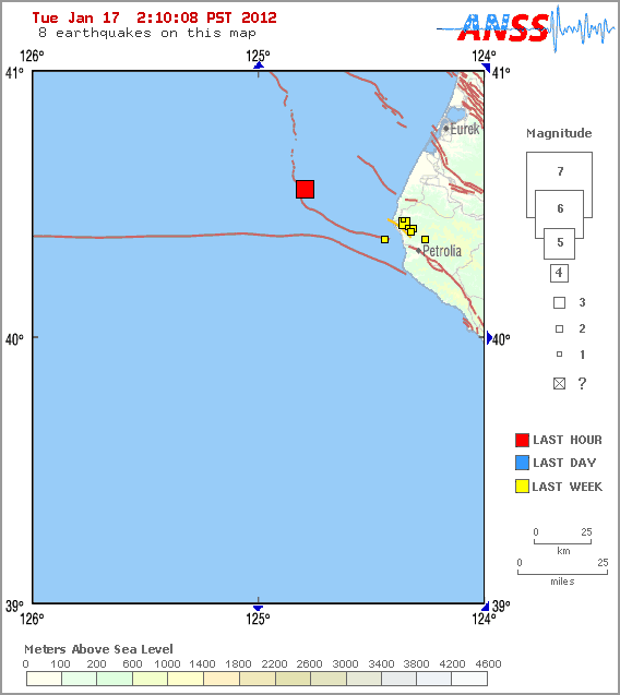
On the seaward edge of the CSZ
Magnitude
4.0
Date-Time
Tuesday, January 17, 2012 at 09:54:58 UTC
Tuesday, January 17, 2012 at 01:54:58 AM at epicenter
Time of Earthquake in other Time Zones
Location
40.556°N, 124.791°W
Depth
2.6 km (1.6 miles)
Region
OFFSHORE NORTHERN CALIFORNIA
Distances
45 km (28 miles) W (267°) from Ferndale, CA
50 km (31 miles) WNW (301°) from Petrolia, CA
53 km (33 miles) WSW (249°) from Humboldt Hill, CA
59 km (37 miles) WSW (244°) from Eureka, CA
361 km (224 miles) NW (309°) from Sacramento, CA
Location Uncertainty
horizontal +/- 1.4 km (0.9 miles); depth +/- 2.3 km (1.4 miles)
Parameters
Nph= 59, Dmin=50 km, Rmss=0.33 sec, Gp=227°,
M-type=local magnitude (ML), Version=4
Source
California Integrated Seismic Net:
USGS Caltech CGS UCB UCSD UNR
Event ID
nc71718846
earthquake.usgs.gov...
eta
www.quakeprediction.com...
he mentions Ferndale at 88% for jan 16th
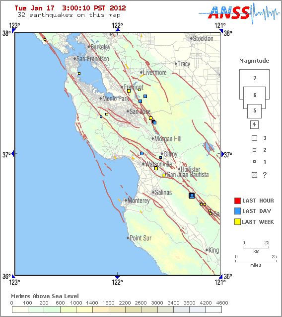
this shows his area of forecast for Watsonville and Santa Cruz
edit on 17-1-2012 by berkeleygal because: (no reason given)
reply to post by katfish
Yep,now it seems that everyone who had been in denial cannot hide any longer.
facking FAQ thread here by yours truly...
Thse mother fracking earh crackers are going to frack us into a bad situation, make no doubt.
Eric, I am a serious metal head and used to have long hair in the 80's and early 90's, there is a lot of energy in that crowd and many of us are very active in trying to make others aware of the damages BIG business has been wreaking on the planet for a long time. I don't have and icon for ya, but I will keep on headbanging!
edit on 17-1-2012 by jadedANDcynical because: typos
edit on 17-1-2012 by jadedANDcynical because:
ugh, more typos
source(earthquake.usgs.gov...
TextMagnitude 5.9 Date-Time Tuesday, January 17, 2012 at 12:55:38 UTC Tuesday, January 17, 2012 at 08:55:38 PM at epicenter Time of Earthquake in other Time Zones Location 11.149°N, 125.857°E Depth 50.3 km (31.3 miles) Region SAMAR, PHILIPPINES Distances 19 km (11 miles) NE of Guiuan, Samar, Philippines 93 km (57 miles) E of Tacloban, Leyte, Philippines 156 km (96 miles) NNE of Surigao, Mindanao, Philippines 652 km (405 miles) SE of MANILA, Philippines Location Uncertainty horizontal +/- 15.2 km (9.4 miles); depth +/- 8.8 km (5.5 miles) Parameters NST=172, Nph=177, Dmin=452 km, Rmss=1.23 sec, Gp= 40°, M-type=regional moment magnitude (Mw), Version=7 Source Magnitude: USGS NEIC (WDCS-D) Location: USGS NEIC (WDCS-D) Event ID usc0007m53
I thought it was only a burb. Nope. There's a small swarm developing on the Madison Plateau overnight. They haven't posted anything yet. At least
one looks around 2.5M.
www.seis.utah.edu...
Pennsylvania has some injection wells.
republicanherald.com...
www.seis.utah.edu...
Pennsylvania has some injection wells.
republicanherald.com...
I know this is just a little guy, but I don't like to see them in Illinois.
Global Quakes
Type: Earthquake 6 hours ago Magnitude: 2.2 DateTime: Tuesday January 17 2012, 11:10:31 UTC Region: Illinois Depth: 0.9 km Source: USGS Feed
Global Quakes
edit on 17-1-2012 by Doodle19815 because: Fix broken link
reply to post by Doodle19815
I did not feel it but at that time there were vicious tornadic storms going through the area. Perhaps pressure changes got the area rocking and rolling.
That particular is very stable-river silt/farmland/lowland. Odd that there was a quake at that place. I plan to drive out there and look around.
I did not feel it but at that time there were vicious tornadic storms going through the area. Perhaps pressure changes got the area rocking and rolling.
That particular is very stable-river silt/farmland/lowland. Odd that there was a quake at that place. I plan to drive out there and look around.
reply to post by katfish
As a person who grew up in the Mattoon/Charelston area anything that happens in IL catches my attention. Especially the quakes, you know with the Madrid and all.
Thanks for the reply, looking forward to your findings.
As a person who grew up in the Mattoon/Charelston area anything that happens in IL catches my attention. Especially the quakes, you know with the Madrid and all.
Thanks for the reply, looking forward to your findings.
Magnitude mb 5.6
Region OFFSHORE COQUIMBO, CHILE
Date time 2012-01-17 23:21:31.0 UTC
Location 31.64 S ; 71.58 W
Depth 10 km
Distances 152 km NW Viña del mar (pop 294,551 ; local time 20:21:31.9 2012-01-17)
39 km W Illapel (pop 22,816 ; local time 20:21:31.9 2012-01-17)
Source parameters not yet reviewed by a seismologist
EMSC
Rainbows
Jane
The Associated Press January 17, 2012, 11:16AM ET
Bulgaria bans Chevron from using 'fracking'
www.businessweek.com/ap/financialnews/D9SAPTR00.htm
Bulgaria bans Chevron from using 'fracking'
www.businessweek.com/ap/financialnews/D9SAPTR00.htm
SOFIA, Bulgaria
Bowing to public pressure, Bulgaria's government says U.S. oil company Chevron cannot explore for shale gas in the country using the extraction technique known as "fracking."
Energy Minister Traicho Traikov said that under Tuesday's decision "Chevron can still have the right to test for oil and gas, but without using the controversial technology of hydraulic fracturing."
He says San Ramon, California-based Chevron had not yet been notified of the decision and negotiations on the contract are pending.
Over the last weeks, thousands of people gathered at protest rallies across Bulgaria to protest against shale gas extraction and the use of fracking, fearing it could have a hazardous impact on the environment and people's health.
(...)
I've just been reading reading about hydroseismicity and have a question for all of our resident seisomo's (as you are far more knowledgeable than
me) - does this theory hold water? (no pun intended!).
For those that do not know, it is the link between water, weather and quakes. The main studies appear to have been on the Indian sub continent and suggest that monsoons over the millenia have eroded far more material than you would normally expect, which has resulted in a faster counter rotation of that plate against its' surrounding neighbours.
There is also a link (allegedly) to the quakes in Louisiana - the huge amounts of water drained and deposited from the water table caused an imbalance in the pressure levels underground, leading to higher stresses on any plates nearby.
I just do not have the technical knowledge to understand if this is viable or not. To a layman it certainly appears possible but there is probably something huge and glaringly obvious i have missed!
If this link could be proved, it would indicate further earthquakes to follow major weather events - possibly significant if we are to believe all the hype about expecting more and stronger storms due to global warming.
source(www.emsc-csem.org...
TextMagnitude Mw 5.9 Region MOLUCCA SEA Date time 2012-01-18 12:50:23.0 UTC Location 0.85 S ; 126.87 E Depth 40 km Distances 190 km S Ternate (pop 101,731 ; local time 21:50:23.3 2012-01-18) 183 km S Tidore (pop 46,149 ; local time 21:50:23.3 2012-01-18)
Magnitude 4.1 - BAJA CALIFORNIA, MEXICO
2012 January 18 13:31:40 UTC
Details
Maps
Scientific & Technical
Earthquake Details
This is a computer-generated message -- this event has not yet been reviewed by a seismologist.
Magnitude
4.1
Date-Time
Wednesday, January 18, 2012 at 13:31:40 UTC
Wednesday, January 18, 2012 at 05:31:40 AM at epicenter
Location
32.345°N, 115.235°W
Depth
0.2 km (~0.1 mile) (poorly constrained)
Region
BAJA CALIFORNIA, MEXICO
Distances
13 km (8 miles) WNW (298°) from Guadalupe Victoria, Baja California, Mexico
40 km (25 miles) SSE (147°) from Mexicali, Baja California, Mexico
44 km (28 miles) SE (146°) from Calexico, CA
169 km (105 miles) E (97°) from Tijuana, Baja California, Mexico
Location Uncertainty
horizontal +/- 2 km (1.2 miles); depth +/- 3.7 km (2.3 miles)
Parameters
Nph= 33, Dmin=50 km, Rmss=0.48 sec, Gp=223°,
M-type=local magnitude (ML), Version=0
Source
California Integrated Seismic Net:
USGSCaltechCGSUCBUCSDUNR
Event ID
ci15098716
Did you feel it? Report shaking and damage at your location. You can also view a map displaying accumulated data from your report and others.
Magnitude ML 4.0
Region ENGLISH CHANNEL
Date time 2012-01-18 18:33:27.0 UTC
Location 49.76 N ; 4.97 W
Depth 10 km
Distances 90 km SW Plymouth (pop 247,297 ; local time 18:33:27.3 2012-01-18)
44 km S Falmouth (pop 22,222 ; local time 18:33:27.3 2012-01-18)
36 km SE Mullion (pop 1,875 ; local time 18:33:27.3 2012-01-18)
EMSC
reply to post by Hellas
Now there's a little turn up!
Has been downgraded now though
Magnitude mb 3.8
Region ENGLISH CHANNEL
Date time 2012-01-18 18:33:27.0 UTC
Location 49.76 N ; 4.97 W
Depth 10 km
Distances 90 km SW Plymouth (pop 247,297 ; local time 18:33:27.3 2012-01-18)
44 km S Falmouth (pop 22,222 ; local time 18:33:27.3 2012-01-18)
36 km SE Mullion (pop 1,875 ; local time 18:33:27.3 2012-01-18)
Source parameters not yet reviewed by a seismologist
Rainbows
Jane
Originally posted by westcoast
Okay guys...need your opinions on this.
I've been watching three stations on Rainier now for about three weeks. Just noticed this odd sig on all of them. I zoomed in a bit on it and I'm stumped. What the heck?
So now this sig just happened just a bit ago up on Rainier. There was some sort of large sig (avalanche?), followed by this 'chatter':
" target='_blank' class='tabOff'/>
PNSN's best guess on this recent activity is that it was an ice avalanche followed by a big chunch chattering down the side.....problem is, this configuration is backwards from what is normally seen. usually, it is the chattering building up to the avalanche.
Anyways, I am just really curious about taking a listen to this. Anyone able/willing to put it together??
Originally posted by angelchemuel
reply to post by Hellas
Now there's a little turn up!
Has been downgraded now though
Magnitude mb 3.8
Region ENGLISH CHANNEL
Date time 2012-01-18 18:33:27.0 UTC
Location 49.76 N ; 4.97 W
Depth 10 km
Distances 90 km SW Plymouth (pop 247,297 ; local time 18:33:27.3 2012-01-18)
44 km S Falmouth (pop 22,222 ; local time 18:33:27.3 2012-01-18)
36 km SE Mullion (pop 1,875 ; local time 18:33:27.3 2012-01-18)
Source parameters not yet reviewed by a seismologist
Rainbows
Jane
This had to be felt though in the area of Plymouth
new topics
-
God's Righteousness is Greater than Our Wrath
Religion, Faith, And Theology: 1 hours ago -
Electrical tricks for saving money
Education and Media: 4 hours ago -
VP's Secret Service agent brawls with other agents at Andrews
Mainstream News: 5 hours ago -
Sunak spinning the sickness figures
Other Current Events: 6 hours ago -
Nearly 70% Of Americans Want Talks To End War In Ukraine
Political Issues: 6 hours ago -
Late Night with the Devil - a really good unusual modern horror film.
Movies: 8 hours ago -
Cats Used as Live Bait to Train Ferocious Pitbulls in Illegal NYC Dogfighting
Social Issues and Civil Unrest: 9 hours ago -
The Good News According to Jesus - Episode 1
Religion, Faith, And Theology: 11 hours ago
top topics
-
Florida man's trip overseas ends in shock over $143,000 T-Mobile phone bill
Social Issues and Civil Unrest: 16 hours ago, 8 flags -
Cats Used as Live Bait to Train Ferocious Pitbulls in Illegal NYC Dogfighting
Social Issues and Civil Unrest: 9 hours ago, 8 flags -
VP's Secret Service agent brawls with other agents at Andrews
Mainstream News: 5 hours ago, 8 flags -
Bobiverse
Fantasy & Science Fiction: 16 hours ago, 3 flags -
HORRIBLE !! Russian Soldier Drinking Own Urine To Survive In Battle
World War Three: 13 hours ago, 3 flags -
Electrical tricks for saving money
Education and Media: 4 hours ago, 3 flags -
Nearly 70% Of Americans Want Talks To End War In Ukraine
Political Issues: 6 hours ago, 3 flags -
Sunak spinning the sickness figures
Other Current Events: 6 hours ago, 3 flags -
Late Night with the Devil - a really good unusual modern horror film.
Movies: 8 hours ago, 2 flags -
The Good News According to Jesus - Episode 1
Religion, Faith, And Theology: 11 hours ago, 1 flags
active topics
-
VP's Secret Service agent brawls with other agents at Andrews
Mainstream News • 36 • : SchrodingersRat -
The Acronym Game .. Pt.3
General Chit Chat • 7744 • : bally001 -
Truth Social goes public, be careful not to lose your money
Mainstream News • 128 • : Astyanax -
New whistleblower Jason Sands speaks on Twitter Spaces last night.
Aliens and UFOs • 53 • : pianopraze -
Sunak spinning the sickness figures
Other Current Events • 5 • : glen200376 -
SETI chief says US has no evidence for alien technology. 'And we never have'
Aliens and UFOs • 44 • : MikeDeGrasseTyson -
HORRIBLE !! Russian Soldier Drinking Own Urine To Survive In Battle
World War Three • 31 • : budzprime69 -
How ageing is" immune deficiency"
Medical Issues & Conspiracies • 33 • : rickymouse -
The Reality of the Laser
Military Projects • 46 • : Zaphod58 -
God's Righteousness is Greater than Our Wrath
Religion, Faith, And Theology • 0 • : randomuser2034