It looks like you're using an Ad Blocker.
Please white-list or disable AboveTopSecret.com in your ad-blocking tool.
Thank you.
Some features of ATS will be disabled while you continue to use an ad-blocker.

Quake Watch 2012
page: 15share:
reply to post by alysha.angel
Were there two earthquakes or just double reporting??
hisz.rsoe.hu...
Were there two earthquakes or just double reporting??
6.7 Mercalli scale: 8 Date-Time [UTC]: 15 January, 2012 at 13:40:18 UTC Local Date/Time: Sunday, January 15, 2012 at 13:40 in the afternoon at epicenter Location: 60° 43.200, 56° 9.000 Depth: 2 km (1.24 miles) Region: South-America Country: Argentina Distances: 866.0 km (538.11 miles) of Bahia Thetis, Source: EMSC Generated Tsunami: Not or no data! Damage: Not or not data!
hisz.rsoe.hu...
I'm curious of how good their gear is regarding quakes down there...
These could be lower or higher in actuality.
...And here are, the receiver is responding to the sender. A quake near the N pole now.
Also there is no tsunami threat based on the area so says the Ptwc.
Bulletin
These could be lower or higher in actuality.
...And here are, the receiver is responding to the sender. A quake near the N pole now.
Magnitude mb 4.8
Region JAN MAYEN ISLAND REGION
Date time 2012-01-15 14:45:57.0 UTC
Location 72.06 N ; 2.32 W
Depth 49 km
Distances 1093 km NW Trondheim (pop 147,139 ; local time 15:45:57.8 2012-01-15)
785 km NW Harstad (pop 19,433 ; local time 15:45:57.8 2012-01-15)
720 km NE Illoqqortoormiut (pop 531 ; local time 13:45:57.8 2012-01-15)
EMSC
Also there is no tsunami threat based on the area so says the Ptwc.
Bulletin
edit on 15/1/12 by murkraz because: (no reason
given)
reply to post by murkraz
6.7 quake, only 2 miles down and no tsunami? That strikes me as odd. Please educate me on how this could be.
6.7 quake, only 2 miles down and no tsunami? That strikes me as odd. Please educate me on how this could be.
There will be movement of water but none that is threatening to anyone in that area or outside of it from the sounds of it. It's under 7, if it was a
high 7 I would be looking at the travel times. I didn't notice that it was at 2km in depth the first time around. They say there's a local tsunami
threat for anything in 100km of the vicinity. Maybe the statement will be revised, I'm unsure of the threat of an earthquake this size with regards to
travel times seeing as it's near Antarctica.
USGS is resting with 6.6 for the first now.
USGS is resting with 6.6 for the first now.
edit on 15/1/12 by murkraz because: (no reason given)
USGS is saying it went like this, two 6.6 earthquakes at the same moment and then a 6.2 to follow. 3 quakes as of a few moments ago.
Update time = Sun Jan 15 16:20:27 UTC 2012
MAP 6.2 2012/01/15 14:21:32 -60.797 -55.999 14.8 SOUTH SHETLAND ISLANDS
MAP 6.6 2012/01/15 13:40:18 -60.765 -55.858 10.0 SOUTH SHETLAND ISLANDS
MAP 6.6 2012/01/15 13:40:17 -60.793 -55.729 1.1 SOUTH SHETLAND ISLANDS
Update: Now we're back to two quakes now. Looks like a USGS error.edit on 15/1/12 by murkraz because: (no reason given)
Originally posted by Jerisa
reply to post by murkraz
6.7 quake, only 2 miles down and no tsunami? That strikes me as odd. Please educate me on how this could be.
Looking at the map, the area is pretty shallow.
They have been reviewed now and it's two events -
6.2 2012/01/15 14:21:32 -60.797 -55.999 14.8km SOUTH SHETLAND ISLANDS
and
6.6 2012/01/15 13:40:18 -60.765 -55.858 10.0km SOUTH SHETLAND ISLANDS
I assume this isn't a subduction zone hence less change of tsunami??
6.2 2012/01/15 14:21:32 -60.797 -55.999 14.8km SOUTH SHETLAND ISLANDS
and
6.6 2012/01/15 13:40:18 -60.765 -55.858 10.0km SOUTH SHETLAND ISLANDS
I assume this isn't a subduction zone hence less change of tsunami??
reply to post by MoorfNZ
Wasn't exactly the spot, but I've been expecting a southern tip of Chile adjustment to the big one there for quite a while, and mentioned this a while back. This might be it, or these could be foreshocks to a bigger one- I was more expecting a quake closer to the direct south tip of Chile, on the west side near the plate junctions.
To Jerisa:
As to why no tsunami, generally it's going to take a 7 or larger, and usually in the upwards of 7.4+ before they are going to worry about any kind of damaging tsunami that is beyond local. 6.6 (and falling after revision) is just not enough.
reply to post by PuterMan
When was that?
I did a ANNS search and got this back
100km radius takes the edge out past the end of the Reykjanes Peninsula, so if it is outside that distance IMO thats too far to blame on hydro injection at Hengill. I stand to be corrected though, you are not often wrong.
Your Reply
Unfortunately you don't get to watch all the Nat Geographic TV shows on Climate Change.
I don't believe CO2 is the "cause" of Climate Change but surely its not helping any.
Just in my back yard we have the Ozone Hole.
I was just trying to make the point that geothermal energy production is probably the safest and cleanest.
If anything the only downside of geothermal injection that has been seen here in NZ is the slightly reduced natural geyser activity. Aquifer pollution and increased earthquake or volcanic activity are non issues.
Hengil? Try mag 6.5 attributed to water injection for steam.
When was that?
I did a ANNS search and got this back
catalog=ANSS
start_time=1970/01/01,00:00:00
end_time=2012/01/15,00:00:00
minimum_magnitude=5.0
maximum_magnitude=10
event_type=E
delta=0 km to 100 km from (64.18,23.33)
No matches to your search criteria
100km radius takes the edge out past the end of the Reykjanes Peninsula, so if it is outside that distance IMO thats too far to blame on hydro injection at Hengill. I stand to be corrected though, you are not often wrong.
...cause climate change and the next ice age.
Your Reply
Sorry not agreed. The coming ice age is being caused by the Sun and has nothing whatsoever to do with 'global climate warming change catastrophic calamity'. That is just sheer unproven BS.
Unfortunately you don't get to watch all the Nat Geographic TV shows on Climate Change.
I don't believe CO2 is the "cause" of Climate Change but surely its not helping any.
Just in my back yard we have the Ozone Hole.
I was just trying to make the point that geothermal energy production is probably the safest and cleanest.
If anything the only downside of geothermal injection that has been seen here in NZ is the slightly reduced natural geyser activity. Aquifer pollution and increased earthquake or volcanic activity are non issues.
edit on 15-1-2012 by muzzy because: (no reason given)
Yes this quadrant has been busy the last 4 days
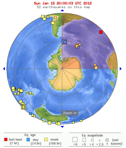
usgs data
5.1, 15/01/2012 19:06, -15.532, -13.283, 16.2, SOUTHERN MID-ATLANTIC RIDGE
5.1, 15/01/2012 18:41, -61.213, -53.528, 15.7, SOUTH SHETLAND ISLANDS
6.2, 15/01/2012 14:21, -60.852, -55.886, 14.2, SOUTH SHETLAND ISLANDS
6.6, 15/01/2012 13:40, -60.765, -55.858, 10, SOUTH SHETLAND ISLANDS
4.9, 15/01/2012 9:24, -60.788, -23.451, 29.5, SOUTH SANDWICH ISLANDS REGION
5.2, 13/01/2012 16:02, -60.591, -27.072, 54.2, SOUTH SANDWICH ISLANDS REGION
5.1, 13/01/2012 15:54, -60.56, -27.276, 67.3, SOUTH SANDWICH ISLANDS REGION
5.3, 12/01/2012 22:08, -52.041, 28.241, 10, SOUTH OF AFRICA
5.5, 12/01/2012 14:11, -52.1, 28.128, 10, SOUTH OF AFRICA
4.9, 12/01/2012 2:52, -53.279, 23.494, 10.4, SOUTH OF AFRICA
4.8, 12/01/2012 2:24, -53.241, 23.628, 10, SOUTH OF AFRICA
4.9, 12/01/2012 2:20, -53.319, 23.402, 10.2, SOUTH OF AFRICA
usgs data
! minute after the South Shetland Islands 6.6
I thought it might be a ghost of the SSI bigun, but looking right now at the NZ Drums you can see it only shows on the upper North Island ones. (at 15hours ago if you look right now)
You cant see the SSI quake on the NZ Drums, they are set differently for close in quakes. Looking at the USGS phases you can see the SSI one arrived from the south end, (MQZ), (RPZ), (WKZ), (ODZ), (WHZ) quite a bit earlier than the North Island ones
5.159ML-13:41:31UTC
REF:3643232
LAT/LONG: -36.57319, 177.21747
UTC: 2012/1/15 13:41:31
NZDT: 2012/1/16 2:41:31
DEPTH: 273km
MAG: 5.159ML
LOCATION: S Ngatoro Basin
Reported as Felt: No
Energy Released: 825.864 tonnes of TNT
I thought it might be a ghost of the SSI bigun, but looking right now at the NZ Drums you can see it only shows on the upper North Island ones. (at 15hours ago if you look right now)
You cant see the SSI quake on the NZ Drums, they are set differently for close in quakes. Looking at the USGS phases you can see the SSI one arrived from the south end, (MQZ), (RPZ), (WKZ), (ODZ), (WHZ) quite a bit earlier than the North Island ones
edit on 16-1-2012 by muzzy because: location location
location
Magnitude 5.5mb
Date-Time
Monday, January 16, 2012 at 03:59:45 UTC
Sunday, January 15, 2012 at 11:59:45 PM at epicenter
Location 60.534°S, 55.967°W
Depth 9.1 km (5.7 miles)
Region SOUTH SHETLAND ISLANDS
Distances 569 km (353 miles) W of Coronation Island, South Orkney Islands
627 km (389 miles) NE of Palmer Station, Antarctica
989 km (614 miles) S of STANLEY, Falkland Islands
2891 km (1796 miles) S of BUENOS AIRES, D.F., Argentina
Location Uncertainty horizontal +/- 23.8 km (14.8 miles); depth +/- 6.5 km (4.0 miles)
Parameters NST= 47, Nph= 48, Dmin=629 km, Rmss=1.88 sec, Gp= 97°,
M-type=body wave magnitude (Mb), Version=6
Source
Magnitude: USGS NEIC (WDCS-D)
Location: USGS NEIC (WDCS-D)
Event ID usc0007liq
earthquake.usgs.gov...
Not converted to Mw
neither was the 6.2, so these are pretty big quakes
FWIW the Russians had
6.5mb, 2012-01-15 13:40:18.0, -60.58, -55.70, 10, South Shetland Islands
6.1mb, 2012-01-15 14:21:31.5, -60.77, -55.87, 10,South Shetland Islands
www.ceme.gsras.ru...
for the earlier ones, not conversion to Ms there either
edit on 15-1-2012 by muzzy because: (no reason given)
edit on
15-1-2012 by muzzy because: (no reason given)
Magnitude
5.5
Date-Time
Monday, January 16, 2012 at 03:59:45 UTC
Sunday, January 15, 2012 at 11:59:45 PM at epicenter
Time of Earthquake in other Time Zones
Location
60.534°S, 55.967°W
Depth
9.1 km (5.7 miles)
Region
SOUTH SHETLAND ISLANDS
Distances
569 km (353 miles) W of Coronation Island, South Orkney Islands
627 km (389 miles) NE of Palmer Station, Antarctica
989 km (614 miles) S of STANLEY, Falkland Islands
2891 km (1796 miles) S of BUENOS AIRES, D.F., Argentina
Location Uncertainty
horizontal +/- 23.8 km (14.8 miles); depth +/- 6.5 km (4.0 miles)
Parameters
NST= 47, Nph= 48, Dmin=629 km, Rmss=1.88 sec, Gp= 97°,
M-type=body wave magnitude (Mb), Version=6
Source
Magnitude: USGS NEIC (WDCS-D)
Location: USGS NEIC (WDCS-D)
Event ID
usc0007liq
earthquake.usgs.gov...
reply to post by berkeleygal
snap
www.abovetopsecret.com...
by 3 minutes
snap
www.abovetopsecret.com...
by 3 minutes
edit on 16-1-2012 by muzzy because: (no reason given)
An update and note.
The first was based on land it shows, the second on water.
USGS
4.6 2012/01/16 06:21:00 35.881 140.428 64.6 NEAR THE EAST COAST OF HONSHU, JAPAN
4.6 2012/01/16 06:29:02 35.668 140.722 53.2 NEAR THE EAST COAST OF HONSHU, JAPAN
54 km (33 miles) S of Mito, Honshu, Japan
65 km (40 miles) ENE of TOKYO, Japan
The first was based on land it shows, the second on water.
USGS
And the UK has another tiddler
DATE 13/01/2012
ORIGIN TIME 20:13:43.6 UTC
LOCATION 49.786 -2.512
DEPTH 5 km
MAGNITUDE 1.7
LOCALITY ENGLISH CHANNEL
BGS
Rainbows
Jane
DATE 13/01/2012
ORIGIN TIME 20:13:43.6 UTC
LOCATION 49.786 -2.512
DEPTH 5 km
MAGNITUDE 1.7
LOCALITY ENGLISH CHANNEL
BGS
Rainbows
Jane
I am Eric Blair. I live in a world more backward, and more absurd, than could ever been imagined in the days after the big war. After a long break
from television, I've recently watched commercials, and have concluded that I must have woke up one day in an alternate reality- one degree to the
right.
I am addicted to thinking about the future. Don't blame me. It's in the genes. Winters are summer. Summer is winter. The invaders are being invaded. Stranger days, no one can imagine.
Me email headlines are making me dizzy. Since I am rushed when checking my mail, I want to scan and move on. But I can't. A reality I imagined is manifesting itself in a constant hum now. People are making the links and asking the questions. Good people. You were slow. But you are at least rejuvinating my faith in us.
Keep on truckin'.
"BRAXTON COUNTY, West Virginia - The West Virginia Department of Environmental Protection says there could be a link between a recent Braxton County earthquake and a brine injection well."
www.wfmj.com...
www.cleveland.com...
www.courierpress.com...
www.recordonline.com.../20120115/NEWS/201150321/-1/SITEMAP
www.workers.org...
www.mysanantonio.com...
www.chicagotribune.com...
www.toledoblade.com...
www.therepublic.com...
www.tulsaworld.com...
I used to like reading about earthquakes. I would wonder about this stress and that stress. (hmm, i'm stressed), and this rock and that roll. Wait. How did I start my study in quakes? oh ya@$E@@
Here's some lighter reading without the passionate politics.
www.trust.org...
www.ouramazingplanet.com...
This one not so light, but informative and thought provoking.
www.nl-aid.org...
Had to add. Finished my emails and checked the big maps. South Dakota 3M. Hmm. I don't have time to investigate. But, I do know South Dakota sure do love fracking for oil and gas.
(i must indulge myself, i am a terrier. jack russell to be more specific. they ar a dog that can be easily mocked. they are only wee dog, with a big nose. they yap and seem manic. but they are only truely understood when you see them at work. they are the most determined and viscious killers of rats in the world. hell, you get more than one together with some others, they can stand up to a bear.)
Had to edit again. I did a quick check on Dakota. But computer I'm on was too slow and I had to stop. Maybe it's nothing to do with fracking- not sure. I'm suspecting irrigation. Hell, it may be natural. Too hard to tell "these" days.
edit on 16-1-2012 by ericblair4891 because: (no reason given)
OOOhh, andhere's another little un in the UK
Just a couple more and it will settle down again
2012/01/16 12:11:50.0 51.652 -3.239 7 1.1 BARGOED,CAERPHILLY 4KM SSW OF BARGOED
BGS
Rainbows
Jane
Just a couple more and it will settle down again
2012/01/16 12:11:50.0 51.652 -3.239 7 1.1 BARGOED,CAERPHILLY 4KM SSW OF BARGOED
BGS
Rainbows
Jane
new topics
-
The Tories may be wiped out after the Election - Serves them Right
Regional Politics: 1 hours ago -
So I saw about 30 UFOs in formation last night.
Aliens and UFOs: 2 hours ago -
Do we live in a simulation similar to The Matrix 1999?
ATS Skunk Works: 3 hours ago -
BREAKING: O’Keefe Media Uncovers who is really running the White House
US Political Madness: 4 hours ago -
Biden--My Uncle Was Eaten By Cannibals
US Political Madness: 5 hours ago -
"We're All Hamas" Heard at Columbia University Protests
Social Issues and Civil Unrest: 5 hours ago -
The good, the Bad and the Ugly!
Diseases and Pandemics: 7 hours ago -
Russian intelligence officer: explosions at defense factories in the USA and Wales may be sabotage
Weaponry: 9 hours ago -
African "Newcomers" Tell NYC They Don't Like the Free Food or Shelter They've Been Given
Social Issues and Civil Unrest: 10 hours ago
top topics
-
BREAKING: O’Keefe Media Uncovers who is really running the White House
US Political Madness: 4 hours ago, 18 flags -
Biden--My Uncle Was Eaten By Cannibals
US Political Madness: 5 hours ago, 15 flags -
African "Newcomers" Tell NYC They Don't Like the Free Food or Shelter They've Been Given
Social Issues and Civil Unrest: 10 hours ago, 12 flags -
Pro Hamas protesters at Columbia claim hit with chemical spray
World War Three: 16 hours ago, 11 flags -
Two Serious Crimes Committed by President JOE BIDEN that are Easy to Impeach Him For.
US Political Madness: 13 hours ago, 7 flags -
911 emergency lines are DOWN across multiple states
Breaking Alternative News: 13 hours ago, 7 flags -
Russia Flooding
Fragile Earth: 12 hours ago, 5 flags -
Former NYT Reporter Attacks Scientists For Misleading Him Over COVID Lab-Leak Theory
Education and Media: 15 hours ago, 5 flags -
So I saw about 30 UFOs in formation last night.
Aliens and UFOs: 2 hours ago, 4 flags -
"We're All Hamas" Heard at Columbia University Protests
Social Issues and Civil Unrest: 5 hours ago, 4 flags
active topics
-
The Tories may be wiped out after the Election - Serves them Right
Regional Politics • 9 • : RussianTroll -
Candidate TRUMP Now Has Crazy Judge JUAN MERCHAN After Him - The Stormy Daniels Hush-Money Case.
Political Conspiracies • 330 • : xuenchen -
The Fight for Election Integrity Continues -- Audits, Criminal Investigations, Legislative Reform
2024 Elections • 4137 • : IndieA -
So I saw about 30 UFOs in formation last night.
Aliens and UFOs • 9 • : andy06shake -
Elites disapearing
Political Conspiracies • 26 • : Freeborn -
It has begun... Iran begins attack on Israel, launches tons of drones towards the country
World War Three • 878 • : WeMustCare -
-@TH3WH17ERABB17- -Q- ---TIME TO SHOW THE WORLD--- -Part- --44--
Dissecting Disinformation • 523 • : Thoughtful3 -
Pro Hamas protesters at Columbia claim hit with chemical spray
World War Three • 15 • : Athetos -
Two Serious Crimes Committed by President JOE BIDEN that are Easy to Impeach Him For.
US Political Madness • 14 • : xuenchen -
Biden--My Uncle Was Eaten By Cannibals
US Political Madness • 29 • : WeMustCare