It looks like you're using an Ad Blocker.
Please white-list or disable AboveTopSecret.com in your ad-blocking tool.
Thank you.
Some features of ATS will be disabled while you continue to use an ad-blocker.

Quake Watch 2012
page: 147share:
magnitude 5.2 centred 20 kms east of christchurch at depth of 12 kilometres.
Originally posted by sled735
I was wondering if someone here can help me find out if there was any tremors going on in East Central MS (USA) on 5/18/12 around 2:30 a.m.?
Someone heard something like a gun battle going on for a long period of time, but can't find a reasonable explanation as to what it was. No reports of such a thing to police. 911 got many calls, but couldn't say what was happening, etc. He also said there was a lot of static in the air because the hair on his arms stood up when he went outside to see what was going on.
I have no idea how to look at earthquake maps. I thought maybe it could be the earth popping making the noise.
His investigation into what it was is ongoing, but so far, it remains a mystery.
Thank you for any assistance you can provide.
not according to this... last one was in 08.
earthquake.usgs.gov...
hope that helps.
Originally posted by BobAthome
reply to post by azureskys
its the same depth,,i dont know baffled,,,
because the centre is viscose,,ok i forgot im a dummy,,
no not hollow,,viscouse,,not solid,,gooey ,,
ok that would work,,
live coverage here in australia via sky news. no damage and no injuries reported. 41 earthquakes above 5 since the initial quake. mainly just
talking about how people are just sick of it now. people have had enough.
reply to post by sled735
Here's an EQ map of the SE USA, and going back to Nov 2011 no EQ in MS.
CERI map out of Memphis
But....what you described fits perfectly with what someone else described in this ATS post at the same time frame(5/18) and same area - East Central MS no less.....ya'll neighbors? Hope this helps.
Here's an EQ map of the SE USA, and going back to Nov 2011 no EQ in MS.
CERI map out of Memphis
But....what you described fits perfectly with what someone else described in this ATS post at the same time frame(5/18) and same area - East Central MS no less.....ya'll neighbors? Hope this helps.
edit on 24-5-2012 by SCGrits because: clarification
Originally posted by SCGrits
reply to post by sled735
Here's an EQ map of the SE USA, and going back to Nov 2011 no EQ in MS.
CERI map out of Memphis
But....what you described fits perfectly with what someone else described in this ATS post at the same time frame(5/18) and same area - East Central MS no less.....ya'll neighbors? Hope this helps.
edit on 24-5-2012 by SCGrits because: clarification
No, just trying trying to help him solve the mystery! I'm a good person that way... Thanks for your help!
Boy it is sure quite out there..... no 7.0s in a long time.... Don't they know this is 2012...
2nd line
2nd line
edit on 24-5-2012 by Xtrozero because: (no reason given)
reply to post by SCGrits
And now it's four....5.0 10km deep... same area.Norwegian Sea....starting to look like Japan all piled up on one another.
And now it's four....5.0 10km deep... same area.Norwegian Sea....starting to look like Japan all piled up on one another.
reply to post by ericblair4891
LDEO have 6.6Mw for the surface wave tensor.
What is not normal? Maybe that it is a bit larger than the usual?
USGS Circular Search: 50km radius
And that is on a small radius. Basically this is on the big crack that runs up past Ireland, through Iceland and on up past Jan Mayen, past the North Pole and then on down through Russia to Japan. Movement on the plate boundary is quite normal.
I don't know what's bugging me about this Norway quake. I know it's not the usual place so that's why I am surprised it's showing up so strong in North America. I would say it's larger than 6.2M. But, this may be becuase of it's location.
LDEO have 6.6Mw for the surface wave tensor.
What is not normal? Maybe that it is a bit larger than the usual?
CAT YEAR MO DA ORIG TIME LAT LONG DEP MAGNITUDE IEM DTSVNWG DIST
NFO km
TF
PDE 1974 08 08 012515.80 73.20 6.19 33 5.2 MsGS ... ....... 27
PDE 1983 01 15 064358.08 73.17 5.72 10 5.3 mbGS ... ....... 17
PDE 1984 06 07 091922.48 73.19 6.42 10 5.0 MsGS ... ....... 32
PDE 1999 04 13 020922.27 73.21 6.65 10 5.1 MwHRV ..M ....... 39
PDE 1999 06 07 161033.63 73.02 5.19 10 5.5 MwHRV ..M ....... 15
PDE 1999 06 07 163546.70 73.08 5.45 10 5.5 MwHRV ..M ....... 9
PDE 2003 08 30 010442.34 73.27 6.42 10 5.4 MwHRV ..M ....... 38
PDE 2007 02 25 215313.56 73.20 6.78 10 5.4 MwGCMT ..M ....... 42
USGS Circular Search: 50km radius
And that is on a small radius. Basically this is on the big crack that runs up past Ireland, through Iceland and on up past Jan Mayen, past the North Pole and then on down through Russia to Japan. Movement on the plate boundary is quite normal.
edit on 25/5/2012 by PuterMan because: give me T, give me an A, give,me a G what have we got -TAG (that needed fixing)
reply to post by PuterMan
It's normal. I said in an earlier post I was confused because I forgot that the epicenter is on the North American plate. I was just surprised it showed up so prominately on N.A. siesmos. It even showed up on Popo in Mexico. And I hadn't seen too many distant quakes show up there. On Yellowstone's webicorders it almost looked like a local quake if you weren't looking closely.
Oh, and you were have right about me ignoring earthquakes in the east of Wyoming. I don't compute them. But I do not ignore them. In fact, they make me crazy. I see them and I feel like I have termites in my house. All that gnawing and chewing all the time. So what right. So what they are mining and blasting like crazy in Eastern Wyoming. There's not many people living there, so there aren't too many complaints right? And now there fracking in Eastern Wyoming. Maybe a little geo-thermal plant here and there in Idaho. shhh.
So, to stay sane I am in a forced sense of denial when it comes to Eastern Wyoming. Because Eastern Wyoming is an isolated case. It's not like Eastern Wyoming is hooked up or connected to anything else. Like Western Wyoming or something. There's nothing in Western Wyoming we need to worry about. Right?
'cept Yogi bear stealing your pininic basket..."
We need not worry about the south western corner of Wyoming either. Cause it doesn't exist. I refuse to accept the existence of a place that looks like some apocolyptic landscape south of the first national park. It doesn't exist.
Neither does fracking sand. In Minnesota, they are mining fracking sand. It spilled into a river. I closed my eyes. and filed it away under the title, please forget. forced denial, then create a deluded state, so you can prevent a cerebral aneurysm.
If i didn't keeping forget they spilled oil in the Yellowstone River, I would never be okay....
Here's popo's siesmo
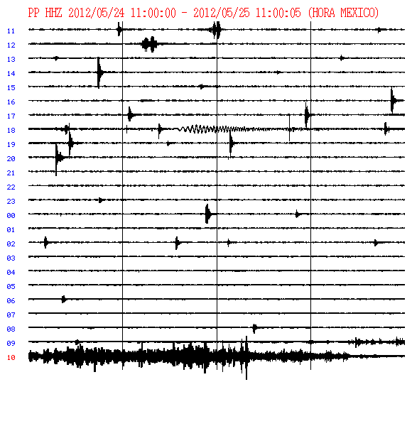
And thank you Puterman for the thumbnail toenail
It's normal. I said in an earlier post I was confused because I forgot that the epicenter is on the North American plate. I was just surprised it showed up so prominately on N.A. siesmos. It even showed up on Popo in Mexico. And I hadn't seen too many distant quakes show up there. On Yellowstone's webicorders it almost looked like a local quake if you weren't looking closely.
Oh, and you were have right about me ignoring earthquakes in the east of Wyoming. I don't compute them. But I do not ignore them. In fact, they make me crazy. I see them and I feel like I have termites in my house. All that gnawing and chewing all the time. So what right. So what they are mining and blasting like crazy in Eastern Wyoming. There's not many people living there, so there aren't too many complaints right? And now there fracking in Eastern Wyoming. Maybe a little geo-thermal plant here and there in Idaho. shhh.
So, to stay sane I am in a forced sense of denial when it comes to Eastern Wyoming. Because Eastern Wyoming is an isolated case. It's not like Eastern Wyoming is hooked up or connected to anything else. Like Western Wyoming or something. There's nothing in Western Wyoming we need to worry about. Right?
'cept Yogi bear stealing your pininic basket..."
We need not worry about the south western corner of Wyoming either. Cause it doesn't exist. I refuse to accept the existence of a place that looks like some apocolyptic landscape south of the first national park. It doesn't exist.
Neither does fracking sand. In Minnesota, they are mining fracking sand. It spilled into a river. I closed my eyes. and filed it away under the title, please forget. forced denial, then create a deluded state, so you can prevent a cerebral aneurysm.
If i didn't keeping forget they spilled oil in the Yellowstone River, I would never be okay....
Here's popo's siesmo
And thank you Puterman for the thumbnail toenail
edit on 25-5-2012 by ericblair4891 because: (no reason given)
Pegusus Bay, NZ 5.5 yesterday
Geonet (Rapid) had 15 goes at this one before listing something competely different in the NZMagma database ~ 5.49
Moved 8.34km NW too
Geofon was the closest at 5.4
Rapid has a long long way to go yet, I reckon quite a few locals could have pinned a 5.4/5.5 on that one within seconds, based on experience.
As a taxpayer I think its a dud, let it go, spend the money somewhere else in GNS, what use is it if it is never right?
Geonet (Rapid) had 15 goes at this one before listing something competely different in the NZMagma database ~ 5.49
ID, TIME, LAT, LONG, DEPTH, MAG, STATUS
2012p392201 2012-05-25 02:44:49.523, -43.52, 172.89, 12, 5.2 (reviewed, 8:46 minutes after) (link)
3711648, 2012-05-25 02:44:50, -43.47284, 172.810151, 5.49 (preliminary, 14hrs later)
Moved 8.34km NW too
Geofon was the closest at 5.4
Rapid has a long long way to go yet, I reckon quite a few locals could have pinned a 5.4/5.5 on that one within seconds, based on experience.
As a taxpayer I think its a dud, let it go, spend the money somewhere else in GNS, what use is it if it is never right?
A special 'treat' for the aficionados of lunar efficaciousness! A chart of all mag 6+ earthquakes for 2012 so far with days after Lunar Perigee, Lunar
Apogee, New Moon and Full Moon. I chopped the rst of the year off for the time being, but I shall be adding to this as we go along. The full year is
about 9000 pixels wide but it has to be this big or everything gets lost.
ETA

ETA
edit on 25/5/2012 by PuterMan because: (no reason given)
More on the subject of Moon, Sun and Ionosphere. I have uploaded most of my Ionospheric TEC map images to YouTube as they are taking up a huge amount
of space (There are or were over 16,000 of them) and no one else can look at them or give an opinion if they are stuck on my PC.
The first one is the end of March this year, and there is one for each week through to the end of the third week of May. The 4th week will be uploaded after the 31st.
Here is the last week as this may be showing some residuals around the Bahamas area.
Enjoy!! (And let me know if you spot anything because basically I don't think it shows any impending earthquakes)
I'm having a bit of a re organisation at Muzzyblogland.
Started NZ mag 5+ this year on Wordpress and have only had 60 hits. The BlogSpot one I have that ran 1930-2011 data has had 17,571 page views, so I think its obvious what to do.
I've shifted the NZ 6+ map and graphs and 2012 over back to Blogspot.
Meanwhile the Wordpress one is being converted to hold the various World regional maps I have scattered about, all in one place.
The maps I'm doing are for Networks that don't have their own interactive maps, so don't expect to see USGS or EMSC, Mexico or Australia there.
Just added Thailand
The events shown on the interactive map below are based on data from TMD since Jan 1 2012
eqarchives.wordpress.com...
screenshot
I might do the Russians, they do a good daily list, but just do individual maps of each event
also Geofon and ................
edit: I added the Plate Boundries to the interactive map since taking the screenshot
Started NZ mag 5+ this year on Wordpress and have only had 60 hits. The BlogSpot one I have that ran 1930-2011 data has had 17,571 page views, so I think its obvious what to do.
I've shifted the NZ 6+ map and graphs and 2012 over back to Blogspot.
Meanwhile the Wordpress one is being converted to hold the various World regional maps I have scattered about, all in one place.
The maps I'm doing are for Networks that don't have their own interactive maps, so don't expect to see USGS or EMSC, Mexico or Australia there.
Just added Thailand
Seismological Bureau, Thai Meteorological Department established an Automatic Earthquake Monitoring System to serve all the needs of raw ground motion data, sea level changes, displacement and analyzed seismic data for the public interest and multi users. The system consists of 40 seismic stations, 26 accelerograph stations, 9 tidal gauge stations , 4 GPS stations.
The events shown on the interactive map below are based on data from TMD since Jan 1 2012
eqarchives.wordpress.com...
screenshot
I might do the Russians, they do a good daily list, but just do individual maps of each event
also Geofon and ................
edit: I added the Plate Boundries to the interactive map since taking the screenshot
edit on 26-5-2012 by muzzy because: (no reason
given)
Prov,Date/Time UTC,Latitude,Longitude,Magnitude,Depth(Km),Location
jmo,2012-05-26 21:49:00, 27.200, 141.100, 6.1, 490.0, Chichijima Kinkai
emsc,2012-05-26 21:48:09, 26.851, 140.190, 5.5, 472.0, Bonin Isls. Japan Region
Something not right here Japanese met office showing 6.1 Ml and emsc showing 5.5 Mw and 51 seconds earlier and 98 km distant from the JMA quake.
ETA: I think that JMA may be out looking at the line of recent very deep subduction quakes. Bit of deep slab pull going on?
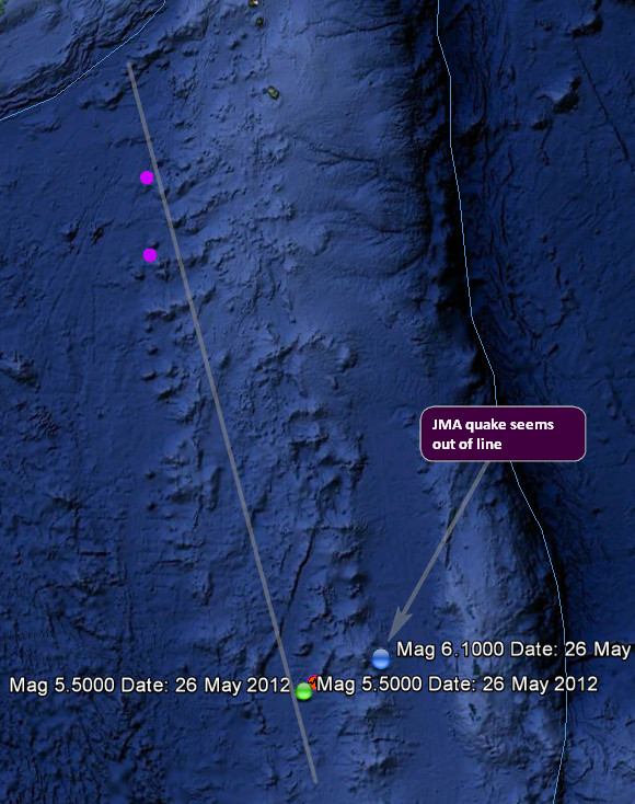
Geofon 5.9 Mw which on the conversion chart is very nearly a Mag 6 on the ML scale so much closer to the JMA estimate than USGS or EMSC which mirror each other @ 5.5 Mw. Something not right here but the problem is it is so deep it really does not show up on LISS at all.
HA, I was just about to post tis next part and checked the list again. USGS have put it up to Mag 6.0
Magnitude 6.0 - Bonin Islands. Japan Region
Location in Google Maps
- Date-Time: Saturday, May 26, 2012 @ 21:48:09 UTC
- Earthquake location: 26.876°N, 140.215°E,
- Earthquake depth: 472.6 km
- Distances:
200km (124mi) W of Chichi-shima, Japan
862km (535mi) SSE of Shingu, Japan
872km (541mi) S of Shimoda, Japan
877km (544mi) SSE of Oyama, Japan
978km (607mi) S of Tokyo, Japan
- Event ID: usb000a07p
Derived from Event Data Source: USGS
Powered by QVSData
edit on 26/5/2012 by PuterMan because: (no reason given)
TMD have 5.9 www.seismology.tmd.go.th...
They use Geofon anyway for their Global source.
edit: been downgraded to 5.5 during the time it took me to copy and paste the address
They use Geofon anyway for their Global source.
edit: been downgraded to 5.5 during the time it took me to copy and paste the address
edit on 26-5-2012 by muzzy because: (no reason
given)
reply to post by muzzy
OK Geofon have downgraded it to 5.5 Mw as well. This is still screwy. USGS had it at 5.5 and put it up, Geofon had it at 5.9 and put it down!
We have a centroid tensor at 6.0 Mw: earthquake.usgs.gov...
And a body wave tensor at 6.0 Mw: earthquake.usgs.gov...
And SCARDEC at 6.0 Mw: www.geoazur.net...
Sorry Geofon, you should not copy EMSC. You are outvoted!!!!
new topics
-
This is our Story
General Entertainment: 1 hours ago -
President BIDEN Vows to Make Americans Pay More Federal Taxes in 2025 - Political Suicide.
2024 Elections: 4 hours ago -
Ode to Artemis
General Chit Chat: 4 hours ago -
Ditching physical money
History: 8 hours ago -
One Flame Throwing Robot Dog for Christmas Please!
Weaponry: 8 hours ago -
Don't take advantage of people just because it seems easy it will backfire
Rant: 8 hours ago -
VirginOfGrand says hello
Introductions: 9 hours ago -
Should Biden Replace Harris With AOC On the 2024 Democrat Ticket?
2024 Elections: 10 hours ago
top topics
-
University student disciplined after saying veganism is wrong and gender fluidity is stupid
Education and Media: 12 hours ago, 12 flags -
Police clash with St George’s Day protesters at central London rally
Social Issues and Civil Unrest: 15 hours ago, 9 flags -
President BIDEN Vows to Make Americans Pay More Federal Taxes in 2025 - Political Suicide.
2024 Elections: 4 hours ago, 8 flags -
TLDR post about ATS and why I love it and hope we all stay together somewhere
General Chit Chat: 16 hours ago, 7 flags -
Should Biden Replace Harris With AOC On the 2024 Democrat Ticket?
2024 Elections: 10 hours ago, 6 flags -
Don't take advantage of people just because it seems easy it will backfire
Rant: 8 hours ago, 4 flags -
One Flame Throwing Robot Dog for Christmas Please!
Weaponry: 8 hours ago, 4 flags -
God lived as a Devil Dog.
Short Stories: 14 hours ago, 3 flags -
Ditching physical money
History: 8 hours ago, 3 flags -
VirginOfGrand says hello
Introductions: 9 hours ago, 2 flags
active topics
-
University student disciplined after saying veganism is wrong and gender fluidity is stupid
Education and Media • 25 • : Consvoli -
British TV Presenter Refuses To Use Guest's Preferred Pronouns
Education and Media • 128 • : Consvoli -
Terrifying Encounters With The Black Eyed Kids
Paranormal Studies • 70 • : burritocat -
Tucker Carlson UFOs are piloted by spiritual entities with bases under the ocean and the ground
Aliens and UFOs • 42 • : Jukiodone -
The Fight for Election Integrity Continues -- Audits, Criminal Investigations, Legislative Reform
2024 Elections • 4143 • : Station27 -
-@TH3WH17ERABB17- -Q- ---TIME TO SHOW THE WORLD--- -Part- --44--
Dissecting Disinformation • 636 • : F2d5thCavv2 -
Russia Ukraine Update Thread - part 3
World War Three • 5719 • : F2d5thCavv2 -
Who guards the guards
US Political Madness • 5 • : 19Bones79 -
One Flame Throwing Robot Dog for Christmas Please!
Weaponry • 6 • : BeTheGoddess2 -
Police clash with St George’s Day protesters at central London rally
Social Issues and Civil Unrest • 37 • : SprocketUK