It looks like you're using an Ad Blocker.
Please white-list or disable AboveTopSecret.com in your ad-blocking tool.
Thank you.
Some features of ATS will be disabled while you continue to use an ad-blocker.

Quake Watch 2012
page: 145share:
reply to post by PuterMan
LOL.. the world isnt flat?
great explanation on the maps I was actually thinking yesterday about our flat maps and how they must confuse people.
this page is a perfect example of why youre the MAN the puterMAN. I learn alot from you thanks again.
well not this page lol pg 144
LOL.. the world isnt flat?
great explanation on the maps I was actually thinking yesterday about our flat maps and how they must confuse people.
this page is a perfect example of why youre the MAN the puterMAN. I learn alot from you thanks again.
well not this page lol pg 144
edit on 5/22/2012 by -W1LL because: 144
LDEO might be off on a few magnitudes (eg N.Italy 6.4) but they are good at finding mid oceanic quakes that the others miss. I have confirmed them all
using the LISS SNZO graphs and the USGS Travel Time Computer
heres a couple more
heres a couple more
2012 5 21 20 7 20.0 -9.25 -108.75 33.0 5.2 CENTRAL EAST PACIFIC RISE
2012 5 22 15 14 24.0 -37.25 78.25 33.0 4.8 MID-INDIAN RIDGE
edit on 22-5-2012 by muzzy because: (no reason given)
Here's a quake that happened on Saturday. It was just posted. It hasn't been reviewed yet.
earthquake.usgs.gov...
It's just creepy is all because it's so close to Sleeply Hollow. Ooooohhh. 12 miles. Near a bridge. Ooooohhh.
The epicenter has oil fields everywhere around it.ooo The epicenter is the same general area as that giant mine blast. I ignore the east of Wyoming because of all the blasts. I saw the signature but it looks like mining. But, it is not 3.8 M I think. I tried to find a trace of it in South Dakotah but couldn't. So....
Your guess is as good as anything.
It's the blue squiggle at the top right, top right- slide right.
Wyoming is going to catch fire one day. And wot stop burnin'.
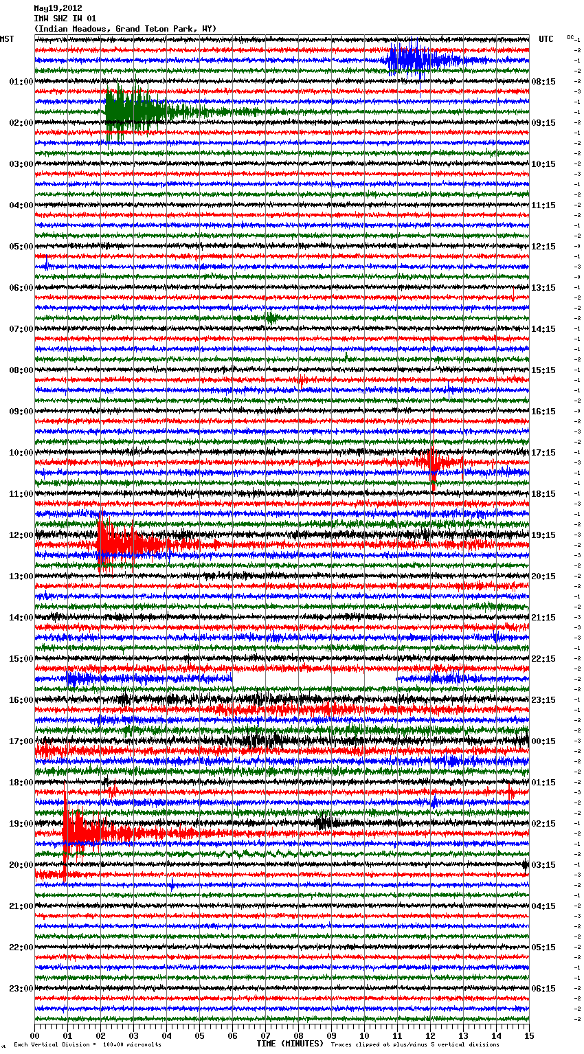
I posted it because something ain't right. I think it's nothing really. it's a computer. oh well. back to sleep
earthquake.usgs.gov...
It's just creepy is all because it's so close to Sleeply Hollow. Ooooohhh. 12 miles. Near a bridge. Ooooohhh.
The epicenter has oil fields everywhere around it.ooo The epicenter is the same general area as that giant mine blast. I ignore the east of Wyoming because of all the blasts. I saw the signature but it looks like mining. But, it is not 3.8 M I think. I tried to find a trace of it in South Dakotah but couldn't. So....
Your guess is as good as anything.
It's the blue squiggle at the top right, top right- slide right.
Wyoming is going to catch fire one day. And wot stop burnin'.
I posted it because something ain't right. I think it's nothing really. it's a computer. oh well. back to sleep
edit on 22-5-2012 by
ericblair4891 because: (no reason given)
edit on 22-5-2012 by ericblair4891 because: (no reason given)
Originally posted by ericblair4891
Here's a quake that happened on Saturday. It was just posted. It hasn't been reviewed yet.
earthquake.usgs.gov...
It's just creepy is all because it's so close to Sleeply Hollow. Ooooohhh. 12 miles. Near a bridge. Ooooohhh.
The epicenter has oil fields everywhere around it.ooo The epicenter is the same general area as that giant mine blast. I ignore the east of Wyoming because of all the blasts. I saw the signature but it looks like mining. But, it is not 3.8 M I think. I tried to find a trace of it in South Dakotah but couldn't. So....
Your guess is as good as anything.
It's the blue squiggle at the top right, top right- slide right.
Wyoming is going to catch fire one day. And wot stop burnin'.
I posted it because something ain't right. I think it's nothing really. it's a computer. oh well. back to sleepedit on 22-5-2012 by ericblair4891 because: (no reason given)edit on 22-5-2012 by ericblair4891 because: (no reason given)
Damn! Someone is always beating me to it! I just noticed this as well. THis is a perfect example of why I do not understand how USGS works. This is an old quake that was just posted. Why would they post this after the fact when quakes are usually picked up, reviewed, and edited afterwards if needed? This is what happened when the Wisconsin booms (among others) were going on. There were booms, shaking, then the USGS comes in and post-dates the info on the site, showing there was a quake. Is it possible that there was a boom or some such thing there and this was posted afterwards to show it was a quake? I just don't trust these after-the-fact postings that happen days later. This was not on the site all day today, let alone over the weekend, now this.
reply to post by mountaingirl1111
In a way Eric's words say it "I ignore the east of Wyoming because of all the blasts." Obviously in an area prone to mine blasts they need time to sort out the wheat from the chaff, or the quakes from the blasts. Also, and I am not particularly defending the USGS or UUSS network here, at the end of the day they have to do what they feel is best for them and we are a secondary consideration.
Source (Emphasis by me)
There has to be a balance between throwing everything out there and adjusting or removing it and checking and posting it. After all if they chucked everything out onto the list and then removed half of it they would be accused of chicanery as well so for them it is a 'lose lose' situation. What ever they do it will be wrong.
We all jump on USGS and I am just as good at it as anyone else, but one also has to remember that sometimes the problems do not lie with "USGS" but with the network that supplies the information (as I have indicated above). It is not one homogeneous organisation as can be attested by the fact that we have the director of the PNSN, John Vidale, posting here - note the PNSN stands for Pacific Northwest Seismic Network. The network letter for this is UW which stands for University of Washington. Here is a part of the Wikipedia entry:
Source
That is just one small example of the 'fracturing' that is present in the 'USGS' organisation whereas we see if as one huge 'company'. It is not.
You could sort of think of it like a franchise. Lots of smaller businesses (networks) doing their own thing and reporting back to 'Head Office' who are the franchise owners rather than the owners.
Not making excuses for them, just trying to explain why sometimes we get frustrated by the lack of timely information.
ETA
It will always be on the seismos, just not in the lists as many have noticed on several occassions.
@Eric - try this

There were booms, shaking, then the USGS comes in and post-dates the info on the site, showing there was a quake. Is it possible that there was a boom or some such thing there and this was posted afterwards to show it was a quake?
In a way Eric's words say it "I ignore the east of Wyoming because of all the blasts." Obviously in an area prone to mine blasts they need time to sort out the wheat from the chaff, or the quakes from the blasts. Also, and I am not particularly defending the USGS or UUSS network here, at the end of the day they have to do what they feel is best for them and we are a secondary consideration.
The first and foremost mission of UUSS is academic research. At the same time - because of its special facilities and expertise - UUSS carries a major burden to meet the needs and expectations of a host of users in Utah and the Intermountain region for earthquake information.
Source (Emphasis by me)
There has to be a balance between throwing everything out there and adjusting or removing it and checking and posting it. After all if they chucked everything out onto the list and then removed half of it they would be accused of chicanery as well so for them it is a 'lose lose' situation. What ever they do it will be wrong.
We all jump on USGS and I am just as good at it as anyone else, but one also has to remember that sometimes the problems do not lie with "USGS" but with the network that supplies the information (as I have indicated above). It is not one homogeneous organisation as can be attested by the fact that we have the director of the PNSN, John Vidale, posting here - note the PNSN stands for Pacific Northwest Seismic Network. The network letter for this is UW which stands for University of Washington. Here is a part of the Wikipedia entry:
The Network operates from the Earth and Space Sciences Department at the University of Washington in Seattle, and its data archiving is abetted by the Data Management Center of IRIS Consortium in Seattle. It is the second largest of the regional seismic networks in the ANSS (Advanced National Seismic System) and with more data than the networks in Alaska, Utah, Nevada, Hawai'i and the New Madrid area.
The network is funded primarily by the US Geological Survey which stations its own staff on the campus although the network is ostensibly managed by UW staff. Additionally the Department of Energy and the State of Washington provide funding.
Source
That is just one small example of the 'fracturing' that is present in the 'USGS' organisation whereas we see if as one huge 'company'. It is not.
You could sort of think of it like a franchise. Lots of smaller businesses (networks) doing their own thing and reporting back to 'Head Office' who are the franchise owners rather than the owners.
Not making excuses for them, just trying to explain why sometimes we get frustrated by the lack of timely information.
ETA
This is an old quake that was just posted.
It will always be on the seismos, just not in the lists as many have noticed on several occassions.
@Eric - try this
edit on 23/5/2012 by PuterMan because: give me T, give me an A, give,me a G what have we got -TAG (that needed fixing)
4.7 Quake in Southern Alaska
earthquake.usgs.gov...
Wednesday, May 23, 2012 at 09:35:29 UTC
Wednesday, May 23, 2012 at 01:35:29 AM at epicenter
Location 59.041°N, 152.901°W
Depth 68.6 km (42.6 miles)
Region SOUTHERN ALASKA
earthquake.usgs.gov...
Wednesday, May 23, 2012 at 09:35:29 UTC
Wednesday, May 23, 2012 at 01:35:29 AM at epicenter
Location 59.041°N, 152.901°W
Depth 68.6 km (42.6 miles)
Region SOUTHERN ALASKA
Japan Mag 6
www.jma.go.jp...
USGS have 6.1 but it has not come through on the lists yet.
earthquake.usgs.gov...
Just came in:
Location in Google Maps
Derived from Event Data Source: USGS
Powered by QVSData
www.jma.go.jp...
Prov,Date/Time UTC,Latitude,Longitude,Magnitude,Depth(Km),Location
jmo,2012-05-23 15:02:00, 41.300, 142.100, 6.0, 50.0, Aomori-Ken Toho-Oki
USGS have 6.1 but it has not come through on the lists yet.
earthquake.usgs.gov...
Just came in:
Magnitude 6.1 - Hokkaido. Japan Region
Location in Google Maps
- Date-Time: Wednesday, May 23, 2012 @ 15:02:25 UTC
- Earthquake location: 41.378°N, 142.073°E,
- Earthquake depth: 40.7 km
- Distances:
72km (44mi) E of Mutsu, Japan
97km (60mi) NE of Misawa, Japan
108km (67mi) NNE of Hachinohe, Japan
108km (67mi) SSW of Shizunai, Japan
664km (412mi) NNE of Tokyo, Japan
- Event ID: usb0009wev
Derived from Event Data Source: USGS
Powered by QVSData
edit on 23/5/2012 by PuterMan because: (no reason given)
Originally posted by lurksoften
reply to post by PuterMan
farther north than the rest of the swarm we had earlier.
I noticed this too. Any chance the swarm and this 6 could be related?
If so wouldn't that put the area more North out of the 9.0 area? Hm.
hopefully this was not a trigger.... but I think there will be more going on the next days
A magnitude 7 or 7.5 earthquake would likely fracture that pool, and disaster would ensue, says Arnie Gundersen, a nuclear engineer with Fairewinds Energy Education who has visited the site.
The 1,535 spent fuel rods would become exposed to the air and would likely catch fire, with the most-recently added fuel rods igniting first.
The incredible heat generated from that blaze, Gundersen said, could then ignite the older fuel in the cooling pool, causing a massive oxygen-eating radiological fire that could not be extinguished with water.
"So the fear is the newest fuel could begin to burn and then we'd have a conflagration of the whole pool because it would become hotter and hotter. The health consequences of that are beyond where science has ever gone before," Gundersen told CTVNews.ca in an interview from his home in Vermont.
Worst-case scenario
There are a couple of possible outcomes, Gundersen said.
Highly radioactive cesium and strontium isotopes would likely go airborne and "volatilize" -- turning into a vapour that could move with the wind, potentially travelling thousands of kilometres from the source.
The size of those particles would determine whether they remained in Japan, or made their way to the rest of Asia and other continents.
"And here's where there's no science because no one's ever dared to attempt the experiment," Gundersen said. "If it flies far enough it goes around the world, if the particles stay a little bigger, they settle in Japan. Either is awful."
Essentially, he said, Japan is sitting on a ticking time bomb.
Read more: www.ctv.ca...
Article
The best we can do is hope and plead with Gaia that no 7s strike in the vicinity.
Originally posted by PuterMan
Then I note that LDEO has this as mag 6.4 Mw
2012 5 20 2 3 52.0 44.75 11.25 33.0 6.4 NORTHERN ITALY
Is it any wonder people are confused about magnitudes!
I am having doubts about LDEO. Remember that they were completely against the swim with the Indonesian quakes 8.6 and 8.2 which they had as 8.0 and 7.8 respectively.
and
Originally posted by JohnVidale
reply to post by PuterMan
The M6.4 at LDEO is from their surface-wave matched filter detector. I'm not sure how it related to their CMT solutions, which generally appear slower.
I just checked, and their CMT has shown up as M6.1
201205200203A NORTHERN ITALY
Date: 2012/ 5/20 Centroid Time: 2: 3:58.5 GMT
Lat= 44.93 Lon= 11.33
Depth= 12.0 Half duration= 2.7
Centroid time minus hypocenter time: 6.2
Moment Tensor: Expo=25 1.450 -1.360 -0.092 -0.467 0.556 0.484
Mw = 6.1 mb = 0.0 Ms = 6.0 Scalar Moment = 1.66e+25
Fault plane: strike=96 dip=35 slip=68
Fault plane: strike=302 dip=58 slip=105
www.globalcmt.org...
Now they have it as a 6.3 and moved it
www.ldeo.columbia.edu...
2012 5 20 2 4 0.0 45.00 11.00 33.0 6.3 NORTHERN ITALY
edit on 23-5-2012 by muzzy because: (no reason given)
And another opinion, from the Aussies
Northern Italy.
Magnitude: 6.0 (Mwp)
Depth: 5 km
Tsunamigenic: No
Date and Time
UTC: 20 May 2012 @ 02:03:52
Sydney Time: 20 May 2012 @ 12:03:52 (AEST)
Location: Casoni Sopra
Coordinates: 44.800, 11.192
Solution status
Last updated: 21 May 2012 @ 13:27:40 (AEST)
Solution finalised: Yes
Source: USGS
www.ga.gov.au...
they used USGS as the source but got a different answer
edit on 23-5-2012 by muzzy because: (no reason given)
4.854ML, 2012/5/23 00:25:54, -37.7909, 175.93826, 308km, Kaimai Ranges, North Island
not felt, too deep
reply to post by muzzy
I have to say that I don't like the 2 decimal point lat.lon on either of those. Highly inaccurate.
They should take a leaf out of GeoNet's book.
I have to say that I don't like the 2 decimal point lat.lon on either of those. Highly inaccurate.
They should take a leaf out of GeoNet's book.
Hey all!
Wanted to share something with all the kiwi's in here.
phys.org...
Wanted to share something with all the kiwi's in here.
Researchers have discovered New Zealand's earthquake-prone landscape is even more unstable than previously thought, recording deep tremors lasting up to 30 minutes on its biggest fault line.
Scientists measured the so-called "creeping earthquakes" when they investigated a puzzling lack of major seismic jolts along a section of the Alpine Fault, which runs the length of the South Island. The quakes, which caused no surface damage, occurred 20-45 kilometres (12-28 miles) beneath the Earth's crust and continued for as long as half an hour, much longer than ordinary earthquakes.
phys.org...
MAP 5.6 05/23 23:19:18 -50.399 139.469 10.0 WESTERN
INDIAN-ANTARCTIC RIDGE
MAP 5.9 05/23 22:59:52 -50.474 139.458 10.0 WESTERN INDIAN-ANTARCTIC RIDGE
MAP 5.9 05/23 22:59:52 -50.474 139.458 10.0 WESTERN INDIAN-ANTARCTIC RIDGE
Originally posted by murkraz
MAP 5.6 05/23 23:19:18 -50.399 139.469 10.0 WESTERN INDIAN-ANTARCTIC RIDGE
MAP 5.9 05/23 22:59:52 -50.474 139.458 10.0 WESTERN INDIAN-ANTARCTIC RIDGE
Was just about to post this.
Walked into the room to see my seismometer had picked up something, maybe two things... and sure enough...
reply to post by alfa1
I am thinking that these are both Mag 6
earthquake.usgs.gov...
Bear in mind that 5.6 is mb and the 5.9 is Mw
SCARDEC have 6.0 Mw
I am thinking that these are both Mag 6
earthquake.usgs.gov...
Bear in mind that 5.6 is mb and the 5.9 is Mw
SCARDEC have 6.0 Mw
edit on 23/5/2012 by PuterMan because: (no reason given)
Magnitude: 5.9
Mercalli scale: 6
Date-Time [UTC]: Wednesday, 23th May 2012 at 10:59 PM
Local Date/Time: Wednesday, May 23, 2012 at 07:59 in the moorning at epicenter
Coordinate: 50° 28.464, 139° 27.486
Depth: 10.00 km (6.21 miles)
Hypocentrum: Shallow depth
Class: Moderate
Region: Australia
Country: Australia
Location: 678.9 km (421.85 miles) S of Pelverata, State of Tasmania, Australia
Source: USGS
is this the quake you are talking about ??? caught my attention when it said the location was tasmania. when you look on the rsoe map it appears to be right on the fault line.
reply to post by PuterMan
I don't see 3 decimal points difference on SNZO between those, maybe 1.
LDEO probably right this time with the magnitude, maybe wrong having the exact same co-ordinates though
makes it difficult to plot the icons on the map, I'll have to put both in the same popup tag until the do a revision (or not)
oops didn't spot the mb/Mw difference you mentioned on USGS
LDEO both in Mw
I don't see 3 decimal points difference on SNZO between those, maybe 1.
LDEO probably right this time with the magnitude, maybe wrong having the exact same co-ordinates though
2012 5 23 23 19 20.0 -50.50 139.50 33.0 5.9 WESTERN INDIAN-ANTARCTIC RIDGE
2012 5 23 22 59 52.0 -50.50 139.50 33.0 6.0 WESTERN INDIAN-ANTARCTIC RIDGE
makes it difficult to plot the icons on the map, I'll have to put both in the same popup tag until the do a revision (or not)
edit on 24-5-2012 by muzzy because: (no reason given)
oops didn't spot the mb/Mw difference you mentioned on USGS
LDEO both in Mw
edit on 24-5-2012 by muzzy because: (no reason given)
new topics
-
God's Righteousness is Greater than Our Wrath
Religion, Faith, And Theology: 1 hours ago -
Electrical tricks for saving money
Education and Media: 4 hours ago -
VP's Secret Service agent brawls with other agents at Andrews
Mainstream News: 5 hours ago -
Sunak spinning the sickness figures
Other Current Events: 6 hours ago -
Nearly 70% Of Americans Want Talks To End War In Ukraine
Political Issues: 6 hours ago -
Late Night with the Devil - a really good unusual modern horror film.
Movies: 8 hours ago -
Cats Used as Live Bait to Train Ferocious Pitbulls in Illegal NYC Dogfighting
Social Issues and Civil Unrest: 10 hours ago -
The Good News According to Jesus - Episode 1
Religion, Faith, And Theology: 11 hours ago
top topics
-
Florida man's trip overseas ends in shock over $143,000 T-Mobile phone bill
Social Issues and Civil Unrest: 16 hours ago, 8 flags -
Cats Used as Live Bait to Train Ferocious Pitbulls in Illegal NYC Dogfighting
Social Issues and Civil Unrest: 10 hours ago, 8 flags -
VP's Secret Service agent brawls with other agents at Andrews
Mainstream News: 5 hours ago, 8 flags -
Bobiverse
Fantasy & Science Fiction: 16 hours ago, 3 flags -
HORRIBLE !! Russian Soldier Drinking Own Urine To Survive In Battle
World War Three: 14 hours ago, 3 flags -
Electrical tricks for saving money
Education and Media: 4 hours ago, 3 flags -
Nearly 70% Of Americans Want Talks To End War In Ukraine
Political Issues: 6 hours ago, 3 flags -
Sunak spinning the sickness figures
Other Current Events: 6 hours ago, 3 flags -
Late Night with the Devil - a really good unusual modern horror film.
Movies: 8 hours ago, 2 flags -
The Good News According to Jesus - Episode 1
Religion, Faith, And Theology: 11 hours ago, 1 flags
active topics
-
Electrical tricks for saving money
Education and Media • 4 • : Lumenari -
Cats Used as Live Bait to Train Ferocious Pitbulls in Illegal NYC Dogfighting
Social Issues and Civil Unrest • 19 • : WeMustCare -
VP's Secret Service agent brawls with other agents at Andrews
Mainstream News • 38 • : SchrodingersRat -
New whistleblower Jason Sands speaks on Twitter Spaces last night.
Aliens and UFOs • 54 • : Ophiuchus1 -
DONALD J. TRUMP - 2024 Candidate for President - His Communications to Americans and the World.
2024 Elections • 514 • : WeMustCare -
The Acronym Game .. Pt.3
General Chit Chat • 7744 • : bally001 -
Truth Social goes public, be careful not to lose your money
Mainstream News • 128 • : Astyanax -
Sunak spinning the sickness figures
Other Current Events • 5 • : glen200376 -
SETI chief says US has no evidence for alien technology. 'And we never have'
Aliens and UFOs • 44 • : MikeDeGrasseTyson -
HORRIBLE !! Russian Soldier Drinking Own Urine To Survive In Battle
World War Three • 31 • : budzprime69