It looks like you're using an Ad Blocker.
Please white-list or disable AboveTopSecret.com in your ad-blocking tool.
Thank you.
Some features of ATS will be disabled while you continue to use an ad-blocker.

Advanced Warning of Double Major Storms For UK Next Week - In Depth Analysis (Be Prepared)
page: 5share:
Those Isobars are tight! I don't know what you guys do for storm protection in the UK, but I live on the East Coast in Florida. We deal with
hurricanes and have corrugated steel we can bolt over windows or lots of people use plywood. The reason for most roof losses during a hurricane (And a
level 3 is a serious storm even here), is the wind gets in under the roof. This is often because windows blow out and then the structure is in danger.
So, keeping the windows covered will help prevent a roof loss.
Now, obviously you guys in the UK are going to have to make judgements as the storm in getting closer as to what actions are required. I know here in Florida when a storm bears down, the plywood, plastic, tarps, water, generators, are the first to fly off the shelves. A week without power and that generator will be sounding good if only to keep the frige cold and get weather updates. So, consider your situation and the soundness of the structure you and your loved ones will ride out the storms in. Then decide what is best for you. I have no clue as to how your homes are built or prepared for storms. Depending on what part of the country here in the US you are in there are different preparedness and construction standards.
I am only posting this for some things to think about. Hopefully, the storms will be reduced in intensity by the time it hits your area, but according to the local weather man here, who by the way was pretty accurate last time, you will be experiencing a severe storm.
If you get an Ice Storm on the backside, you can expect power lines to be down for awhile. Good luck to all you who are going to be experience mother nature's wrath.
Why can't anyone post a thread on this site anymore without someone jumping in and calling "Fearmonger".
The OP has posted an informative thread on storms that will hit the UK. He is bringing us good information and telling us to be prepared, he is not fear mongering.
Quit it with the: "This is nothing, if you lived in so and so areas or countries, you would really know what a storm was like".
This isn't a contest!!
[/End Rant]
Thank you OP for the information and updates S+F
edit on 10-12-2011 by skitzspiricy because: (no reason given)
Thanks for the updates and analysis
North-West here, Liverpool to be specific. Will be checking here regularly for updates, with members all over the UK our collective input should give people good valuable info.
Hopefully its not as bad as the models are predicting
North-West here, Liverpool to be specific. Will be checking here regularly for updates, with members all over the UK our collective input should give people good valuable info.
Hopefully its not as bad as the models are predicting
Brief Update
One of the latest model runs has the central pressure at a STAGGERING 920mb. This is unprecidented and never before recorded in the UK. IF this came off, this would be the worst storm ever recorded in UK history. This storm with a central pressure of 920mb would provide sustained winds of over 90mph. This would devastate large portions of the UK.
The Night of the Big Wind in Irish Foklore was estimated to have a central pressure of 918mb's, so for compariative reasons, it may be worth while reading up on the Wiki entry.
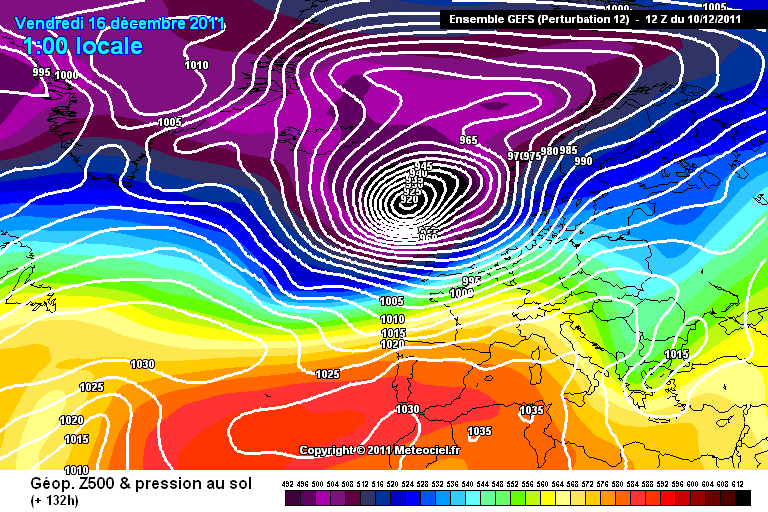
Now although this central pressure is unlikely, it could occur, especially given that models are prediciting it. As a side note, no one has EVER seen a model run this low over the UK before. That fact in itself is worth a mention!
Now you can at least say you have seen "The Model Run That Showed A Pressure Of 920mb's Over The UK"...
That is one scary ass*d image, especially for those in the know with model reading!
And just to clarify, if this pressure actually occurred, this would be the equal 17th deepest storm system ever recorded on earth. There is not a lot of people who can say they have experienced worse. Only those in hurricane prones areas. Link
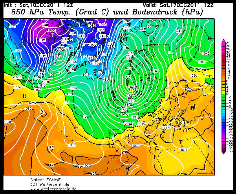
Thought i'd throw this chart in aswell. Once the LP swings east, you can see the isobars lining up to a more N/NE direction. This means that there is an increased possibility of a fair few snow showers rattling the East of the UK in the storms wake. Just another ingredient to add to the mix...
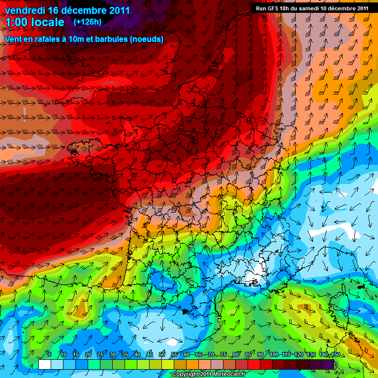
As you can see here, wind gusts are literally off the chart...the key goes up to 150kph (90mph) which is dented by the purple seen over NW England. As you can see there is a deep Black area that is beyond 150kph that isn't measurable...
One of the latest model runs has the central pressure at a STAGGERING 920mb. This is unprecidented and never before recorded in the UK. IF this came off, this would be the worst storm ever recorded in UK history. This storm with a central pressure of 920mb would provide sustained winds of over 90mph. This would devastate large portions of the UK.
The Night of the Big Wind in Irish Foklore was estimated to have a central pressure of 918mb's, so for compariative reasons, it may be worth while reading up on the Wiki entry.
Now although this central pressure is unlikely, it could occur, especially given that models are prediciting it. As a side note, no one has EVER seen a model run this low over the UK before. That fact in itself is worth a mention!
Now you can at least say you have seen "The Model Run That Showed A Pressure Of 920mb's Over The UK"...
That is one scary ass*d image, especially for those in the know with model reading!
And just to clarify, if this pressure actually occurred, this would be the equal 17th deepest storm system ever recorded on earth. There is not a lot of people who can say they have experienced worse. Only those in hurricane prones areas. Link
edit on 10/12/11 by jrmcleod because: (no reason
given)
Thought i'd throw this chart in aswell. Once the LP swings east, you can see the isobars lining up to a more N/NE direction. This means that there is an increased possibility of a fair few snow showers rattling the East of the UK in the storms wake. Just another ingredient to add to the mix...
edit on 10/12/11 by jrmcleod because: (no reason given)
edit on 10/12/11 by jrmcleod because: (no
reason given)
As you can see here, wind gusts are literally off the chart...the key goes up to 150kph (90mph) which is dented by the purple seen over NW England. As you can see there is a deep Black area that is beyond 150kph that isn't measurable...
edit on 10/12/11 by jrmcleod because: (no reason
given)
reply to post by jrmcleod
How good is the source of this material? I've not heard of them and the Met Office surface pressure charts don't go beyond Tuesday.
How good is the source of this material? I've not heard of them and the Met Office surface pressure charts don't go beyond Tuesday.
Originally posted by phoenix103
reply to post by jrmcleod
How good is the source of this material? I've not heard of them and the Met Office surface pressure charts don't go beyond Tuesday.
These are the charts the MetO use. They are used globally by all the major weather companies. They are produced by a number of different super computers in Europe, North America and Asia. Apart from using "old wives tales" to predict the weather, there is nothing better!
The MetO charts will be updated tomorrow morning.
A yellow alert has been issued from the met office for Wednesday and Thursday for high winds.
www.metoffice.gov.uk...
Maybe they know something but are keeping it calm for now?
www.metoffice.gov.uk...
Maybe they know something but are keeping it calm for now?
reply to post by jrmcleod
JRM
Please could you let me know if the West Midlands is in line to be hit? I want to prepare myself, my family and girlfriend just in case.
JRM
Please could you let me know if the West Midlands is in line to be hit? I want to prepare myself, my family and girlfriend just in case.
This is pretty damn scary. How would eastern England be affected? More precisely East Anglia.
edit on 10/12/2011 by diamount because: (no
reason given)
Originally posted by godofme
reply to post by jrmcleod
JRM
Please could you let me know if the West Midlands is in line to be hit? I want to prepare myself, my family and girlfriend just in case.
Yes they are. let me restate this...
There is NO WHERE in the UK that will escape these storms. How severe your area is hit will change over the coming days but as it stands right here and now, the North of England and the Midlands could be hit the hardest on Friday.
This will change over the next few days but whether or not the models get it bang on is another matter...all we can do is wait until the beginning of the week when the timeframe for error is reduced!
Originally posted by jrmcleod
Just on a point worth mentioning. If any of you live in Cenral London or within a stones throw of the Thames, please be aware that the Thames Barrier will most likely be activated if Fridays storm verifys. As with the Novemebr 9th 1997 incodent, people may be evacuated as a precaution so be prepared to move if needed!
London may experience something similar or worse than Glasgow with a phenomena known as tidal blocking. This is a situation where the water cant flow out of the river because of the high tide. There is the possibility of Tidal Blocking in London that could in effect, "back-up" the Thames.
As I mentioned in your previous thread JR I'm in Essex about 50 miles east of london I can see the Thames if I walk 5 round the corner. If or when the storm hits I'll let you know how it is down here. So is there going to be snow in this storm or just high winds ... You promised me snow JR lol. Good thread(s) though mate I'll be watching the weather closely
So surprised that met office hasn't said anything
reply to post by jrmcleod
Hi yeah, they're GFS runs if memory serves? What i mean is, is the organisation which has produced the ones cited in your posts known to have a good track record, particularly this far out?
Meant to add, i'm extremely grateful for your posts on here on this subject. I'm a member of Netweather but don't check the forums until something comes onto the radar (so to speak) and i'm no expert on the details.
I'm supposed to be travelling on Friday night but if this comes of its an absolute non starter and rather concerning in a general sense!
Originally posted by godofme
reply to post by jrmcleod
JRM
Please could you let me know if the West Midlands is in line to be hit? I want to prepare myself, my family and girlfriend just in case.
Please don't overly worry at this stage , but it won't hurt to be prepared .
Keep checking back here and also check for updates at the links provided by the OP .
Terry
Originally posted by ThePeaceMaker
So surprised that met office hasn't said anything
They did, its going to be another record hot December because of GW
edit on 10-12-2011 by StarTraveller because: (no reason
given)
Originally posted by phoenix103
reply to post by jrmcleod
Hi yeah, they're GFS runs if memory serves? What i mean is, is the organisation which has produced the ones cited in your posts known to have a good track record, particularly this far out?
Meant to add, i'm extremely grateful for your posts on here on this subject. I'm a member of Netweather but don't check the forums until something comes onto the radar (so to speak) and i'm no expert on the details.
I'm supposed to be travelling on Friday night but if this comes of its an absolute non starter and rather concerning in a general sense!
If your a member of Netweather i'd recommend you go on their and read up on what they are dicussing. As you'll know there are some very "in the know" people there that are more clued up than me. None of the models are wholly accurate, GFS and the UKMO are pretty good but when all models suggest the same thing you know its going to happen, which is whats hapening just now. All that stands to be measured is the intensity which will be refined nearer the time!
reply to post by jrmcleod
That is severe for the North Atlantic. You were mentioning the low countries before. I hope their flood abatement systems are ready for a workout. Many people don't realize what 'sustained 90mph' winds are like in a storm. The continuous blowing for hours can wear down a structure and cause failure where gusts may not. I am kind of wondering if the models will go any lower. Do you call these by anything besides a super storm, like a hurricane. It would meet the Saffir-Simpson scale for wind speeds and lows in the Northern Hemisphere rotate in the same cyclonic direction.
Saffir-Simpson Hurricane Scale
Originally posted by ThePeaceMaker
Originally posted by jrmcleod
Just on a point worth mentioning. If any of you live in Cenral London or within a stones throw of the Thames, please be aware that the Thames Barrier will most likely be activated if Fridays storm verifys. As with the Novemebr 9th 1997 incodent, people may be evacuated as a precaution so be prepared to move if needed!
London may experience something similar or worse than Glasgow with a phenomena known as tidal blocking. This is a situation where the water cant flow out of the river because of the high tide. There is the possibility of Tidal Blocking in London that could in effect, "back-up" the Thames.
As I mentioned in your previous thread JR I'm in Essex about 50 miles east of london I can see the Thames if I walk 5 round the corner. If or when the storm hits I'll let you know how it is down here. So is there going to be snow in this storm or just high winds ... You promised me snow JR lol. Good thread(s) though mate I'll be watching the weather closely
So surprised that met office hasn't said anything
I wouldnt be surprised if there was snow once the LP had moved into the North Sea, especially for the east. You need to remember that winds travel anti-clockwise in a LP, see Brief Update above regarding snow!!!
reply to post by jrmcleod
Well thank you for a well intended post. I live in London, near one of the many docks and experience high winds even on a calm summer's day due to the channelling effect caused by the many new-build flats.
There has been some chronic wind recently but today has been relatively calm. I will report back on the 16th ... that is if the wind doesn't knock my flat straight off the tenth floor!!!
edit on 10-12-2011 by george_gaz because: typo
Originally posted by spirit_horse
reply to post by jrmcleod
That is severe for the North Atlantic. You were mentioning the low countries before. I hope their flood abatement systems are ready for a workout. Many people don't realize what 'sustained 90mph' winds are like in a storm. The continuous blowing for hours can wear down a structure and cause failure where gusts may not. I am kind of wondering if the models will go any lower. Do you call these by anything besides a super storm, like a hurricane. It would meet the Saffir-Simpson scale for wind speeds and lows in the Northern Hemisphere rotate in the same cyclonic direction.
Saffir-Simpson Hurricane Scale
The MetO will refuse to call this a Hurricane because it didnt form over waters where the temperature of the sea was 26oC or above. This is a mid-latitude extratropical cyclone. Albeit a very deep one.
Will the models go lower? I sure as hell hope not...personally i dont think it will be 920mb's, i'd hazard a guess at about 940-960mb's, which is still very deep and dangerous.
new topics
-
Thousands Of Young Ukrainian Men Trying To Flee The Country To Avoid Conscription And The War
Other Current Events: 1 hours ago -
12 jurors selected in Trump criminal trial
US Political Madness: 4 hours ago -
Iran launches Retalliation Strike 4.18.24
World War Three: 4 hours ago -
Israeli Missile Strikes in Iran, Explosions in Syria + Iraq
World War Three: 5 hours ago -
George Knapp AMA on DI
Area 51 and other Facilities: 10 hours ago -
Not Aliens but a Nazi Occult Inspired and then Science Rendered Design.
Aliens and UFOs: 10 hours ago
top topics
-
BREAKING: O’Keefe Media Uncovers who is really running the White House
US Political Madness: 17 hours ago, 26 flags -
George Knapp AMA on DI
Area 51 and other Facilities: 10 hours ago, 25 flags -
Israeli Missile Strikes in Iran, Explosions in Syria + Iraq
World War Three: 5 hours ago, 13 flags -
Louisiana Lawmakers Seek to Limit Public Access to Government Records
Political Issues: 13 hours ago, 7 flags -
Iran launches Retalliation Strike 4.18.24
World War Three: 4 hours ago, 6 flags -
So I saw about 30 UFOs in formation last night.
Aliens and UFOs: 16 hours ago, 6 flags -
Not Aliens but a Nazi Occult Inspired and then Science Rendered Design.
Aliens and UFOs: 10 hours ago, 5 flags -
Do we live in a simulation similar to The Matrix 1999?
ATS Skunk Works: 17 hours ago, 4 flags -
The Tories may be wiped out after the Election - Serves them Right
Regional Politics: 14 hours ago, 3 flags -
12 jurors selected in Trump criminal trial
US Political Madness: 4 hours ago, 3 flags
active topics
-
Iran launches Retalliation Strike 4.18.24
World War Three • 15 • : semperfortis -
Russia Ukraine Update Thread - part 3
World War Three • 5696 • : Kenzo -
President BIDEN Warned IRAN Not to Attack ISRAEL - Iran Responded with a Military Attack on Israel.
World War Three • 43 • : WeMustCare -
Israeli Missile Strikes in Iran, Explosions in Syria + Iraq
World War Three • 52 • : WeMustCare -
Mandela Effect - It Happened to Me!
The Gray Area • 107 • : inflaymes69 -
Terrifying Encounters With The Black Eyed Kids
Paranormal Studies • 45 • : daskakik -
Not Aliens but a Nazi Occult Inspired and then Science Rendered Design.
Aliens and UFOs • 12 • : BeyondKnowledge3 -
Elites disapearing
Political Conspiracies • 31 • : Degradation33 -
MULTIPLE SKYMASTER MESSAGES GOING OUT
World War Three • 47 • : SchrodingersRat -
12 jurors selected in Trump criminal trial
US Political Madness • 21 • : VictorVonDoom